Dispatch Weather Midterm
 Call Kai
 Learn
Learn Practice Test
 Spaced Repetition
 Match
Match Flashcards
 Knowt Play
1/227

There's no tags or description
Looks like no tags are added yet.
Name | Mastery | Learn | Test | Matching | Spaced | Call with Kai | Chat |
|---|
No analytics yet
Send a link to your students to track their progress
228 Terms
Where is the usual location of a thermal low
Over the surface of a dry, sunny region.
Over the artic region.
Over the eye of a hurricane.
Over the surface of a dry, sunny region
Which weather phenomenon signals the beginning of the mature stage of a thunderstorm?
The start of rain at the surface
The appearance of an anvil top
Growth rate of the cloud is at its maximum
the start of rain at the surface
What is a feature of supercooled water?
The temperature of the water drop remains at 0°C until it impacts a part of the airframe, then clear ice accumulates
The unstable water drop freezes upon striking an exposed object
The water drop sublimates to an ice particle upon impact
the unstable water drop freezes upon striking an exposed object
which weather condition is an example of a nonfrontal instability band?
Squall line
Frontogenesis
Advective fog
squall line
the rate of decrease in wind speed from the jet stream core is considerably greater on the
acute angle side
polar side
equatorial side
polar side
which of the following will decrease the holding time during anti-icing using a two-step process?
Increase the viscosity of Type 1 fluid
Apply heated Type 2 fluid
Decrease the water content
apply heated type 2 fluid
anti-icing fluid should provide freezing point protection to
a freezing point no greater than 20°F below the ambient or aeroplane surface temperature
- 20°F ambient temperature
+32°F outside temperature or below
a freezing point no greater than 20 degrees below the ambient or aeroplane surface temperature
for a flight to an airport in the vicinity of the coast, land surface cooling means you can expect to encounter
land breezes
a chinook wind
sea breezes
land breezes
when does minimum temperature normally occur during a 24 hour period?
After sunrise
At midnight
About 1 hour before sunrise
after sunrise
which event usually occurs after an aircraft passes through a front into the colder air?
Wind direction shifts to the left
Atmospheric pressure increases
Temperature/dewpoint spread decreases
atmospheric pressure increases
In the International Terminal Aerodrome Forecast (TAF), a variable wind direction is noted by "VRB" where the three digit direction usually appears. A calm wind appears in the TAF as
00003KT
00000KT
VRB00KT
00000KT
Maximum downdrafts in a microburst encounter may be as strong as
6,000 ft/min
8,000 ft/min
7,000 ft/min
6,000 ft/min
Where are jetstreams normally located?
In a single continuous band, encircling the Earth, where there is a break between the equatorial and polar tropopause
In a break in the tropopause where intensified temperature gradients are located
In areas of strong low pressure systems in the stratosphere
In a break in the tropopause where intensified temperature gradients are located
what is the minimum glycol content of type 1 deicing/anti-icing fluid?
30 percent
80 percent
50 percent
80 percent
In this METAR excerpt, "SLP993 SNINCR 1/10" means
0.1" of snow on the runway land zone during the last hour
1" of snow in the last 10 hours
1" and a total of 10" of snow is on the ground with 1" in the last hour
1" and a total of 10" of snow is on the ground with 1" in the last hour
Which area or areas of the Northern Hemisphere experience a generally east to west movement of weather systems?
Artic only
Artic and subtropical
Subtropical only
Artic and Subtropical
When does the National Weather Service release an Aviation Notification Watch Message (SAW)?
At 0000 (UTC)
Unscheduled and issued as required
At 0000 and 1200 (UTC)
Unscheduled and issued as required
What type turbulence should be reported when it causes slight, rapid,and somewhat rhythmic bumpiness without appreciable changes in attitude or altitude less than one-third of the time?
Occasional light chop
Moderate chop
Moderate turbulence
Occasional light chop
Which type precipitation is an indication that supercooled water is present?
Freezing rain
Ice pellets
Wet snow
Freezing rain
What hazard should you expect for a morning departure from KPDX, based on this METAR?KPDX 271154Z 00000KT 9SM CLR -10/-10 A2979.
Frost on the aircraft
Sea breeze
Wind shear
Frost on the aircraft
When saturated air moves downhill, its temperature increases
at a faster rate than dry air because of the release of latent heat
at a slower rate than dry air because condensation releases heat
at a slower rate than dry air because vapourisation uses heat
at a slower rate than dry air because vapourisation uses heat
An aircraft that encounters a headwind of 40 knots, within a microburst, may expect a total shear across the microburst of
90 knots
80 knots
40 knots
80 knots
A clear area in a line of thunderstorm echoes on a radar scope indicates
an area where precipitation drops are not detected
the absence of clouds in the area
an area of no convective turbulence
An area where precipitation drops are not detected
A calm wind that is forecast, in the International Terminal Aerodrome Forecast (TAF) is encoded as
00000KT
00003KT
VRB00KT
00000KT
Which wind-shear condition results in an increase in airspeed?
Decreasing tailwind and increasing headwind
Increasing tailwind and headwind
Increasing tailwind and decreasing headwind
Decreasing tailwind and increasing headwind
What action is recommended when encountering turbulence due to a wind shift associated with a sharp pressure trough?
Increase speed to get out of the trough as soon as possible
Climb or descend to a smoother level
Establish a straight course across the storm area
Establish a straight course across the storm area
Jetstreams are strongest during which season in the Northern Hemisphere?
Winter
Spring
Summer
Winter
Maximum downdrafts in a microburst encounter may be as strong as
6,000 ft/min
8,000 ft/min
7,000 ft/min
6,000 ft/min
What is indicated about an air mass if the temperature remains unchanged or decreases slightly as altitude is increased?
The air is unstable
A temperature inversion exists
The air is stable
The air is stable
What is the primary cause of all changes in the Earth's weather?
Variations of solar energy at the earth's surface.
Movement of air masses from moist areas to dry areas
Changes in air pressure over the Earth's surface.
Vibrations of solar energy at the earth's surface
What's an important characteristic of wind shear?
It is primarily associated with the lateral vortices generated by thunderstorms
It usually exists only in the vicinity of thunderstorms, but may be found near a strong temperature inversion
It may be associated with either a wind shift or a windspeed gradient at any level in the atmosphere
It may be associated with either a wind shift or a windspeed gradient at any level in the atmosphere
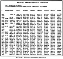
(Refer to Figure 149.) What approximate wind direction, speed, and temperature (relative to ISA) expected for for a a flight over TUS at FL270?
350° true; 5 knots; ISA +5°C
010° true; 5 knots; ISA +13°C
347° magnetic; 5 knots; ISA -10°C
010° true; 5 knots; ISA +13°C

(Refer to Figure 144.) If involved in a microburst encounter, in which aircraft positions will the most severe downdraft occur?
4 & 5
2 & 3
3 & 4
3&4

The symbol ($) at the end of the following METARindicates thatMETAR KFSM 131756Z AUTO 00000KT M1/4SM R25/0600V1000FT -RA FG VV004 06/05 A2989 RMK AO2 $
he latest information is broadcast on the voice portion of a local navaid at KFSM
the latest information is transmitted over a discrete VHF frequency at KFSM
maintenance is needed on the system
Maintenance is needed on the system
What is a feature of a stationary front?
Surface winds tend to flow parallel to the frontal zone
The warm front surface moves about half the speed of the cold front surfaces
Weather conditions are a combination of strong cold front and strong warm front weather
Surface winds tend to flow parallel to the frontal zone
Which INITIAL cockpit indications should a pilot ALL be aware of when a headwind shears to a calm wind?
Indicated airspeed decreases, aircraft pitches down, and altitude decreases
Indicated airspeed decreases, aircraft pitches up, and altitude decreases
Indicated airspeed increases, aircraft pitches down, and altitude increases
Indicated airspeed decreases, aircraft pitches down, and altitude decreases
In which meteorological conditions can frontal waves and low pressure areas form?
Cold front occlusions
Warm fronts or occluded fronts
Slow-moving cold fronts or stationary fronts
Slow-moving cold fronts or stationary fronts
Temperature and radiation variations over land with a clear sky typically lead to
minimum temperature occurring after sunrise
incoming terrestrial radiation peaking at noon
temperature reaching a maximum closer to noon than to sunset
Incoming terrestrial radiation peaking at noon
The adverse effects of ice, snow, or frost on aircraft performance and flight characteristics include decreased lift and
an increased stall speed
a decreased stall speed
increased thrust
An increased stall speed
(Refer to Figure 149.) What approximate wind direction, speed, and temperature (relative to ISA) are expected for a flight over OKC at FL370?
260° true; 27 knots; ISA +6°C
265° true; 27 knots; ISA +1°C
260° magnetic; 27 knots; ISA +10°C
260° true; 27 knots; ISA +6°C

Volcanic Ash Advisory charts are updated every
4 hours
12 hours
6 hours
6 hours
Low pressure areas are areas of
ascending air
descending air
stagnant air
ascending air
What is the lowest cloud in the stationary group associated with a mountain wave?
Rotor cloud
Standing lenticular
Low stratus
rotor cloud
How can the stability of the atmosphere be determined?
Atmospheric pressure at various levels
Ambient temperature lapse rate
Surface temperature/dewpoint spread
Ambient temperature lapse rate
If squalls are reported at the destination airport, what wind conditions exist?
Sudden increases in windspeed of at least 15 knots, to a sustained wind speed of 20 knots, lasting for at least 1 minute
A sudden increase in wind speed of at least 16 knots, the speed rising to 22 knots or more for 1 minute or longer
Rapid variation in wind direction of at least 20° and changes in speed of at least 10 knots between peaks and lulls
A sudden increase in wind speed of at least 16 knots, the speed rising to 22 knots or more for 1 minute or longer
Cumulus clouds often indicate
possible turbulence
a temperature inversion
a dry adiabatic lapse rate
possible turbulence
What type turbulence should be reported when it causes changes in altitude and/or attitude more than two-thirds of the time, with the aircraft remaining in positive control at all times?
Continuous severe chop
Continuous moderate turbulence
Intermittent moderate turbulence
Continuous moderate turbulence
How are haze layers cleared or dispersed?
By evaporation similar to the clearing of fog
By convective mixing in cool night air
By wind or the movement of air
By wind or the movement of air
When high level moisture is available, cirrus clouds form on the
acute angle side of the jet stream
equatorial side of the jet stream
polar side of the jet stream
equatorial side of the jet stream
Which action is recommended regarding an altitude change to get out of jetstream turbulence?
Descend if ambient temperature is rising
Maintain altitude if ambient temperature is not changing
Descend if ambient temperature is falling
Descend if ambient temperature is failing
Convective clouds which penetrate a stratus layer can produce which threat to instrument flight?
Embedded thunderstorms
Freezing rain
Clear air turbulence
Embedded thunderstorms
Which action is recommended if jetstream turbulence is encountered with a direct headwind or tailwind?
Change altitude or course to avoid a possible elongated turbulent area
Increase airspeed to get out of the area quickly
Change course to fly on the polar side of the jetstream
Change altitude or course to avoid a possible elongated turbulent area
What temperature condition is indicated if precipitation in the form of wet snow occurs during flight?
The temperature is above freezing at higher altitudes
The temperature is above freezing at flight altitude
There is an inversion with colder air below
The temperature is above freezing at flight altitude
METAR KHRO 131753Z 09007KT 7SM FEW020
BKN040 30/27 A3001
SPECI KHRO 131815Z 13017G26KT 3SM +TSRA SCT020 BKN045TCU 29/24 A2983
RMK RAB12 WS TKO LDG RW14R FRQ LTGICCG VC
What change has taken place between 1753 and 1815 UTC at Harrison (KHRO)?
The ceiling lowered and cumulonimbus clouds developed
Visibility reduced to IFR conditions
Thundershowers began at 12 minutes past the hour
Thunderstorms began at 12 minutes past the hour
Steep frontal surfaces are usually associated with
fast moving cold front
fast moving warm front
dry lines
fast moving cold front
(Refer to Figure 149.) What will be the wind and temperature trend for an STL MEM MSY flight at FL330?
Wind shift from west to north
Windspeed decrease
Temperature increase 5°C
Windspeed decrease

What characterises a ground-based inversion?
Poor visibility
Cold temperatures
Convection currents at the surface
Poor visibility
The practice developed and accepted by the North American air carrier industry using traditional North American fluids is to ensure that the freeze point of the remaining film is below ambient temperature by at least
20°F
20°C
10°F
20°F
The threshold wind speed in the jet stream for clear air turbulence is generally considered to be
100 kts
110 kts
120 kts
110 kts
If icing is suspected on an airplane equipped with deicing equipment, the pilot should
first confirm ice with the ice light prior to deploying the pneumatic boots
operate the pneumatic deicing system several times to clear the ice
operate the pneumatic deicing system once to allow time for the ice removal
operate the pneumatic deicing system several times to clear the ice
Which are the only cloud types forecast in the Terminal Aerodrome Forecast?
Cumulonimbus
Altocumulus
Stratocumulus
Cumulonimbus
Constant Pressure Analysis Charts contain contours, isotherms and some contain isotachs. The contours depict
ridges, lows, troughs and highs aloft
highs, lows, troughs, and ridges on the surface
highs, lows, troughs, and ridges corrected to MSL
ridges, lows, troughs and highs aloft
During the life cycle of a thunderstorm, which stage is characterised predominately by downdrafts?
Mature
Cumulus
Dissipating
Dissipating
What sources reflect the most accurate information on current and forecast icing conditions?
AIRMET Zulus
Low-Level Sig Weather Prog Chart, RADATs, and the Area Forecast
PIREPs, Area Forecast, and the Freezing Level Chart
AIRMET Zulus
If the winds aloft are blowing parallel to the front,
the front can be expected to move with the upper winds
the front moves slowly if at all
the winds aloft can be expected to turn at the frontal boundary
The front moves slowly if at all
(Refer to Figure 144.) How will the aircraft in position 4 be affected by a microburst encounter?
Performance increasing with a tailwind and updraft
Performance decreasing with a tailwind and downdraft
Performance decreasing with a headwind and downdraft
Performance decreasing with a tailwind and downdraft

What is the feature of air movement in a high pressure area?
Descending to the surface and then outward.
Moving outward from the high at high altitudes and into the high at the surface.
Ascending from the surface high to lower pressure at higher altitudes.
Descending to the surface and then outward
The purpose of diluting ethylene glycol deicing fluid with water in non-precipitation conditions is to
increase the minimum freezing point (onset of crystallisation)
raise the eutectic point
decrease the freeze point
Decrease the freeze point
Which initial cockpit indications should a pilot be aware of when a constant headwind shears to a calm wind?
Altitude pitch, and indicated airspeed decrease
Altitude increases; pitch and indicated airspeed decrease
Altitude, pitch, and indicated airspeed increase
Altitude pitch, and indicated airspeed decrease
(Refer to Figure 145.) What was the local Central Standard Time of the Aviation Routine Weather Report at Austin (KAUS)?
5:53 p.m.
10:53 p.m.
11:53 a.m.
11:53 am

Where can the maximum hazard zone caused by wind shear associated with a thunderstorm be found?
On all sides and directly under the thunderstorm cell
Ahead of the roll cloud or gust front and directly under the anvil cloud
In front of the thunderstorm cell (anvil side) and on the southwest side of the cell
On all sides and directly under the thunderstorm cell
Where do the maximum winds associated with the jetstream usually occur?
Below the jet core where a long straight stretch of the jetstream is located
In the vicinity of breaks in the tropopause on the polar side of the jet core
On the equatorial side of the jetstream where moisture has formed cirriform clouds
In the vicinity of breaks in the tropopause on the polar side of the jet core
Data that may be added (manual weather augmentation) to the Automated Weather Observing System (AWOS) report is limited to
density Altitude, NOTAMs, and reported slant range visibility
the precipitation accumulation report, an automated variable visibility and wind direction remark
thunderstorms (intensity and direction). precipitation (type and intensity), and obstructions to visibility (dependent on the visibility being 3 miles or less)
thunderstorms (intensity and direction). precipitation (type and intensity), and obstructions to visibility (dependent on the visibility being 3 miles or less)
Turbulence encountered above 15,000 feet AGL, not associated with cloud formations, should be reported as
high altitude turbulence
convective turbulence
clear air turbulence
clear air turbulence
Freezing rain encountered during climb is normally evidence that
a climb can be made to a higher altitude without encountering more than light icing
ice pellets at higher altitudes have changed to rain in the warmer air below
a layer of warmer air exists above
A layer of warmer air exists above
What condition is indicated when ice pellets are encountered during flight?
Thunderstorms at higher levels
Freezing rain at higher levels
Snow at higher levels
Freezing rain at higher levels
The prevailing visibility in the following METAR isMETAR KFSM 131756Z AUTO 00000KT M1/4SM R25/0600V1000FT -RA FG VV004 06/05 A2989 RMK AO2 $
a mean (average) of 1/4 statute mile
measured 1/4 statute mile
less than 1/4 statute mile
less than 1/4 statute mile
Which of the following weather conditions are conducive to inflight icing?
Visible rain with temperatures below 0°C
Visible rain with temperatures below 10°C
Visible moisture with temperatures below 5°C
Visible rain with temperatures below 0°C
Which type jetstream can be expected to cause the greater turbulence?
A straight jetstream associated with with a high pressure ridge
A curving jetstream associated with a deep low pressure trough
A jetstream associated with a wide isotherm spacing
A curving jetstream associated with a deep low pressure trough
What wind direction and speed aloft are forecast by this WINDS AND TEMPERATURE ALOFT FORECAST (FD) for FL390 - "731960"?
230 at 119 knots
073° at 196 knots
131° at 96 knots
230 at 119 knots
What is the recommended technique to counter the loss of airspeed and resultant lift from wind shear?
Lower the pitch attitude and regain lost airspeed
Avoid overstressing the aircraft, "pitch to airspeed," and apply maximum power
Maintain, or increase, pitch attitude and accept the lower-than-normal airspeed indications
Maintain, or increase, pitch attitude and accept the lower-than-normal airspeed indications
Which type of weather can only be directly observed during flight and then reported in PIREP
Jetstream-type winds and icing
Turbulence and structural icing
Level of the tropopause and turbulence
Turbulence and structural icing
(Refer to Figure 144.) On final approach to the airport, aeroplane in position #5 would experience
decreased ground speed
downdraft
poor performance
Poor performance
(Refer to Figure 149A, Area 10.) What is the forecasted wind direction, speed, and temperature over ELY at 30,000 feet?
330°, 35 knots, 33 °C
040°, 35 knots, -33 °C
220°, 35 knots, -33 °C
220°, 35 knots, -33 °C
What is a difference between an air mass thunderstorm and a steady-state thunderstorm?
Air mass thunderstorm downdrafts and precipitation retard and reverse the updrafts
Air mass thunderstorm produce precipitation which falls outside of the updraft
Steady-state thunderstorms are associated with local surface heating
Air mass thunderstorm downdrafts and precipitation retard and reverse the updrafts
Precipitation induced fog
results from relatively cooler rain or drizzle falling through warmer air
is usually of short duration
results from relatively warm rain or drizzle falling through cooler air
results from relatively warm rain or drizzle falling through cooler air
(Refer to Figure 146.) What was the celling at Walnut Ridge (KARG)?
1,000 feet AGL
2,400 feet AGL
1,000 feet MSL
1,000 ft AGL
Which is definition of "severe wind shear?"
Any rapid change in wind direction or velocity which causes airspeed changes greater than 15 knots or vertical speed changes greater than 500 ft/min
Any change of airspeed greater than 20 knots which is sustained for more than 20 seconds or vertical speed changes in excess of 100 ft/min
Any rapid change of horizontal wind shear in excess of 25 knots; vertical shear excepted
Any rapid change in wind direction or velocity which causes airspeed changes greater than 15 knots or vertical speed changes greater than 500 ft/min
(Refer to Figure 149.) What will be the wind and temperature trend for an SAT ELP TUS light at 16,000 feet?
Wind direction shift from southwest to east
Windspeed decrease
Temperature decrease slightly
Wind direction shift from southwest to east
SPECI KGLS 131802Z 10012G21KT 060V140 2SM +SHRA SCT005 BKN035 OVC050CB 24/23 A2980 RMK RAB1757 WS TKO RWO9L WSHFT 58 FROPA.
This SPECI report at Galveston (KGLS) indicates which condition?
Precipitation started at 1757
Wind steady at 100 magnetic at 12 knots, gusts to 21
5,000 feet overcast with towering cumulus
Precipitation started at 1757
(Refer to Figure 145.) What type of report is listed for Lubbock (KLBB) at 1818Z?
A special report concerning very low statior pressure
A Special METAR weather observation concerning significant weather changes
An Aviation selected special weather report
An Aviation selected special weather report

When will frost most likely form on aircraft surfaces?
On clear nights with stable air and light winds
On clear nights with convective action and a small temperature/dewpoint spread
On overcast nights with freezing drizzle precipitation
On clear nights with stable air and light winds
METAR KFSO 030900Z VRB02KT 7SM MIFG SKC 15/14 A3012 RMK SLP993 6///// T01500139 56012In the above METAR, the "SLP993 6/////" indicates
sea-level pressure 993.6 hectopascals and that four-tenths of an inch of precipitation has fallen in the last 6 hours
sea-level pressure 993.6 hectopascals that has dropped .4 hectopascals in the last 6 hours
sea-level pressure 993.6 hectopascals and that an indeterminable amount of precipitation has occurred over the last 3 hours
sea-level pressure 993.6 hectopascals and that an indeterminable amount of precipitation has occurred over the last 3 hours
During an IFR cross-country flight you picked up rime icing which you estimate is 1/2" thick on the leading edge of the wings. You are now below the clouds at 2000 feet AGL and are approaching your destinationairport under VFR. Visibility under the clouds is more than 10 miles, winds at the destination airport are 8 knots right down the runway, and the surface temperature is 3 degrees Celsius. You decide to:
fly your approach slower than normal to lessen the "wind chill" effect and break up the ice
approach and land at your normal speed since the ice is not thick enough to have any noticeable effect
use a faster than normal approach and landing speed
use a faster than normal approach and landing speed
Where is a common location for an inversion?
At the base of cumulus clouds
In the stratosphere
At the tropopause
In the stratosphere
What is the minimum glycol content of Type 2 deicing/anti-icing fluid?
50 percent
80 percent
30 percent
50%
Summer thunderstorms in the artic region will generally move
northeast to southwest in polar easterlies
southwest to northeast with the jetstream flow
directly north to south with the low-level polar airflow
northeast to southwest in polar easterlies
A jetstream is a narrow, shallow, meandering river of maximum winds extending around the globe in a wavelike pattern with speeds of
71 kts or greater
50 kts or greater
100 kts or greater
50kts or greater
(Refer to Figure 145.) What condition is reported at Dallas (KDAL)?
Temperature/dewpoint spread is 8°F
Altimeter setting is 30.07
The tops of the overcast is 10,000 feet
Altimeter setting is 30.07

Which procedure increases holding time when deicing/anti-icing an airplane using a two-step process?
Cold Type 2 fluid followed by hot Type 2 fluid
Heated Type 1 fluid followed by cold Type 2 fluid
Heated Type 1 or 2 fluid followed by cold Type 1 fluid
Heated Type 1 fluid followed by cold Type 2 fluid