Paper 2 Section A - The Uk's evolving physical landscape
1/73
There's no tags or description
Looks like no tags are added yet.
Name | Mastery | Learn | Test | Matching | Spaced | Call with Kai |
|---|
No analytics yet
Send a link to your students to track their progress
74 Terms
Name the three different types of rock:
State how they are formed
Their characteristics
Where they are found in the UK
Examples for each
Igneous rocks
When lava cools and solidifies on the surface
The molten rock crystallises as it cools producing sparkly quartz within the rock; very hard and resistant; interlocking crystalline structure makes it impermeable
Predominantly found in the upland areas of Scotland, North Wales and Northern Ireland
Examples: Granite, basalt
Sedimentary rocks
When weathering breaks existing rocks into particles (sediment) which are transported and deposited in layers; over time compress under pressure to form rock.
Made of distinct layers (as sediment is deposited in stages), usually softer and less resistant, sometimes contain fossils, often permeable due to gaps between sediment and many joints
Lowland areas of South England and South Wales
Examples: Chalk, carboniferous limestone, sandstone, clay
Metamorphic rocks
Formed when existing rocks undergo intense heat and pressure
Very hard and resistant and usually impermeable (as the minerals have been compressed very tightly together), banded (as different minerals align into different bands/layers)
Upland areas of North Scotland, Northern Ireland, North Wales
Examples: Schist, slate, marble
Describe the role of geology, past tectonic and glacial processes in the development of upland and lowland landscapes
Geology:
Igneous and metamorphic rocks are harder and more resistant to erosion, so tend to form upland landscapes
Sedimentary rocks are usually softer and less resistant to erosion, so tend to form lowland land scapes
Past tectonic processes:
Active volcanoes: millions of years ago, the UK used to be closer to a plate boundary; active volcanoes on the plate boundary forced magma through the Earth’s crust, which cooled to form igneous rocks (forming upland landscapes)
Plate collisions: caused rocks to be folded and uplifted, forming upland mountain ranges.
Plate collisions: the intense heat and pressure caused by plate collisions formed metamorphic rocks (forming upland landscapes)
Plate movements: millions of years ago, past plate movements meant that Britain was in the tropics, and higher sea levels meant that it was partly under water.
Carboniferous limestone formed in the warm shallow seas when marine creatures died, forming uplands in South West England and Wales
Past glacial processes:
During glacial periods, large glaciers moved, eroding the landscape and carving out u-shaped valleys
When glaciers melted, they deposited lots of material. Large parts of Eastern England are still covered in till that was deposited
HANGING VALLEYS
OUTWASH PLAINS
MISFIT STREAMS
Describe the physical processes that have shaped the UK’s physical landscape
Erosion; wearing and transportation of rock away
Weathering: breakdown of rock into smaller pieces (mechanical, chemical, biological)
Post-glacial river processes: after glaciers melted, rivers had greater discharge and therefore greater power to erode the landscape
Slope processes (including mass movements)
Physical processes are affected by the climate (decreased/ increased)
Describe the different types of weathering
Mechanical: breakdown of rocks through physical force without changing their chemical composition
Eg. salt weathering (as salt expands when water evaporates, widening cracks)
Chemical: breakdown of rocks by changing its chemical composition
Eg. carbonation weathering as carbon dioxide dissolved in rain and oceans forms weak carbonic acids
Biological: breakdown of rocks by living things
Eg. plant roots growing into rocks and pushing them apart
Describe the different types of mass movement
Mass movement is the shifting of rocks and loose materials down a slope; it occurs when the force of gravity acting on the slope is greater than the force supporting it
Slides: material shifts in a straight line
Slumps: material shifts with a rotation
Rockfalls: material breaks up and falls down a slope
Describe the different types of erosion
Hydraulic action: waves crash against rocks and compress the air in the cracks, putting pressure on the rocks. This repeated compression widens the cracks and makes bits of rocks break off
Abrasion: sediment in the water scrapes and rubs against the rock removing small pieces
Attrition: sediment in the water smash into each other and break into smaller fragments
Solution: acidic water dissolves the rock, causing it to wear away
Describe how humans have caused distinctive landscapes to form
Agriculture
People have cleared the land of forest to make space for cattle/ sheep farming
Hedgerows and walls have been built to mark out fields
Drainage ditches have been dug to make land dry enough for farming
Forestry:
Trees have been planted in straight lines for timber
When trees are felled, the landscape is left bare
Some trees are being replanted to attempt to return the landscape to a more natural state
Settlement:
Land was concreted over for roads and buildings
Some rivers were diverted or straightened
Some rivers had embankments built to prevent flooding
Explain the two different types of coastline and name the different landforms formed on each
Concordant: rock strata is parallel to the coastline
High cliffs, coves
Disconcordant: rock strata is perpendicular to the coastline
Headlands and bays
What are joints and faults?
Joints - small, vertical cracks in rocks
Faults - larger cracks
Explain why some coastlines erode more quickly than others
Geology
Coastlines with soft, less resistant rock will erode more quickly
Human activities/ value of land
(How human activities have effects on the coastline (eg. development, agriculture, industry, coastal management)
Waves
The type of wave (constructive/ destructive) and the wave’s fetch and energy will affect the rate of coastal erosion
Explain how coves are formed
Coves are an erosional landform:
They form on concordant coastlines
Erosion (name of erosion) weakens the rock, forming joints and cracks
Over time the hard, resistant rock erodes to expose the soft, less resistant rock behind
The less resistant rock erodes much faster than the more resistant rock, so the cove widens more in the soft rock band
Erosion continues to widen the cove, but cannot extend further inland due to the band of rock behind the soft rock, which forms steep cliffs
Explain how wave-cut platforms are formed
Wave cut platforms are an erosional landform:
Waves cause most erosion at the foot of a cliff
This forms a wave-cut notch, which is enlarged as erosion continues
The rock above the notch becomes unstable and eventually collapses
The collapsed material is washed away and a new wave-cut notched starts to form
The repeated collapsing results in the cliff retreating
A wave-cut platform is the platform left behind as the cliff retreats
Explain how bays and headlands are formed
Headlands and bays are erosional landforms:
They form along disconcordant coastlines
Soft rocks or rocks with lots of joints are less resistant to erosion compared to hard rocks with a solid structure
The less resistant rock is eroded away quickly forming a bay
The resistant rock is eroded more slowly and is left jutting out, forming a headland
Explain how caves through stumps are formed
Caves through stumps are erosional landforms:
They form on disconcordant coastlines on headlands
Cave, arch, stack, stump
Waves crash into the base of the headlands enlarging cracks through hydraulic action and abrasion
Repeated erosion and enlargement of cracks cause a cave to form
Continued erosion deepens the cave until it breaks through the headland forming an arch
Erosion continues to wear away the rock supporting the arch until it eventually collapses
This forms a stack
As erosion continues to attack the base of the stack, eventually it will collapse into a stump
Describe the impact of the UK’s climate on coastal erosion and retreat
Climate: the long term patterns of weather conditions in a specific area
Different seasons bring different weathers:
In Summer, warm temperatures increase the rate of salt weathering
In Winter, low temperatures cause freeze-thaw weathering
Strong winds from storms create high energy, destructive waves which increase erosion
Intense rainfall can cause cliffs to become saturated, causing mass movement
Prevailing wind: mostly south westerlies which bring storms from the Atlantic Ocean; the UK’s south coast is exposed to these winds
Describe the different types of waves
Constructive waves are depositional (they deposit more material than they erode), so build up beach material
Strong swash
Weak backwash
Low wave height
High wavelength
Low wave frequency
Destructive waves are erosional (they arode more material than they deposit), so they remove beach material from the coast
Weak swash
Strong backwash
High wave height
Low wavelength
High wave frequency
What is a wave’s fetch?
The distance of the sea over which the wave has travelled
Describe the process of longshore drift
Longshore drift is the process by which material is transported along coasts
Waves follow the direction of the prevailing wind
They usually hit the coastline at an oblique angle (in the direction of the prevailing wind)
The swash carries material up the beach in the same direction as the waves
The backwash carries material back down the beach at right angles due to gravity
Over time this causes material to zig zag along the coastline
Describe how beaches are formed
A beach is a depositional landform; beaches are large deposits of shingle and sand
Deposition occurs when water carrying sediment slows down/ loses energy so that it isn’t moving fast enough to continue to carry the sediment, thus dropping it
Constructive waves have a strong swash, so carry large amounts of material onto the coast
However, they have a weak backwash so cannot carry the material back, thus depositing material such as sand and shingle along the coast to form beaches
Explain how a spit is formed
Spits are depositional landforms; they are long narrow strips of beach material
Sediment moved along a coastline by longshore drift (1) in direction of prevailing wind (1). The coastline changes direction (1) but the deposition of sediment continues (1)
Spits form at sharp bends in the coastline
Longshore drift transports sand and shingle past the bend and deposits it into the sea as it loses energy (usually due to going into a sheltered area behind the bend in the coastline)
If the prevailing wind changes direction, strong winds and waves can curve the end of the spit, forming a recurved end
The sheltered area behind the spit is protected from waves, therefore lots of material can accumulate behind this area, which means that plants can grow there
Over time the sheltered area can become a mud flat or salt marsh
Explain how a bar is formed
Bars are depositional landforms; bars are spits that have grown across the mouth of a bay
A bar is formed when a spit joints two headlands together
The bar cuts off the bay between the headlands from the sea
This means that a lagoon can form behind the bar
How to identify coastal landforms on maps (Caves-stumps, cliffs, wave cut platforms, spits)
Caves, arches, stacks, stumps
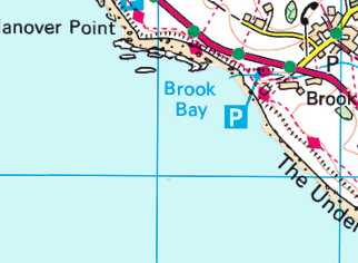
Cliffs

Wave cut platforms

(Shown as bumpy edges along the coast)
Spits
Explain how human activities have effects on the coastline
Development, agriculture, industry, coastal management
Development:
Coastal areas are popular to live in, so often have lots of development infrastructure (eg. hotels, shops, homes, roads, power lines etc.)
Positive effects:
May mean more coastal protection as land has a greater value
Negative effects:
Building on cliffs adds weight to them, making them unstable and causing mass movement
Impermeable surfaces may alter natural drainage system (water goes to cliffs, saturated, mass movement)
Infrastructure may alter natural sediment movement (interrupt longshore drift) along the coast (starving further parts)
Agriculture:
Clearing vegetation (eg. for grazing land)
Vegetation helps to bind soil together to stabilise cliffs with their roots. Removing this can make cliffs unstable and cause mass movement
Can expose underlying rock beneath the vegetation, making it vulnerable to weathering by wind and rain
Land (eg. marshland) is sometimes reclaimed and drained for agricultural use.
Reduces natural flood barrier that marshland provides
Industry:
Coastal quarries (mine/ excavation sites) expose large areas of rock, making them more vulnerable to weathering and erosion
Gravel has been extracted from beaches for use in construction industries; this leads to increased erosion as there is less material to protect the cliffs
Industrial growth at ports has led to increased pressure to build on marshland - building on them removes the land's natural flood barrier, leaving it more vulnerable to erosion
Coastal management:
Some management strategies (eg. groynes) can alter sediment movement, restricting it from reaching further down the coast. This can make the beach narrower, increasing erosion
Coastal defences can reduce erosion, which prevents the landscape from changing (eg. retreating)
Describe the significance of the coastal case study location
Named location: Christchurch bay
Located on England’s WEST coast,
Vulnerable to powerful, long-fetch, destructive waves from the Atlantic
Lots of residential areas and developments around the bay (HEAVY MANUFACTURING)
Weak, less resistant geology (weak clays and sandstones)
The coastal landscape surrounding Christchurch bay has experienced landslides and cliff collapses due to extensive erosion and instability on the coastline.
Describe the physical processes along a named coastal landscape
Named coastal landscape: Christchurch bay
Experiences South westerlies which bring full-force destructive waves from the Atlantic; these waves have a long fetch so are very powerful
These waves quickly erode the cliff bases (through hydraulic action and abrasion), making them unstable and vulnerable to collapse
The cliffs are made of sandstones and clays; these rock types are easily eroded and weathered as they are very soft
Its sandstone geology is highly permeable, meaning that water infiltrates the cliffs easily and saturates the cliffs during wet periods. This adds weight, increases instability and causes mass movement and cliff collapse
Describe the human processes along a named coastal landscape
Named coastal landscape: Christchurch bay
Decades of erosion has caused the coastline to retreat by tens of metres, meaning that now many buildings are very close to the cliffs.
This extra weight on the cliff edge can cause cliffs to become too unstable and collapse (several houses and a cafe have already been lost)
Poor planning has led to terminal groyne syndrome; starved the beach of sediment further east, causing rapid erosion
Residential and industrial developments have led to impermeable surfaces further inland and altered the natural drainage system of the coastal area; more water is drained directly into cliffs, causing them to become saturated, leading to mass movement
Explain why there are increasing risks for coastal flooding
Climate change is causing an increased frequency of storms and rising sea levels
Storm frequency
Storms bring high winds that give the sea more erosional power, removing natural defenses
The sea will have more energy to transport material over longer distances; this could lead to some areas being starved of material, leaving those areas vulnerable to erosion and flooding
Storm surges could become more frequent, leading to more frequent flooding
Rising sea levels: as seas warm up, it leads to thermal expansion, so the volume of water in the ocean becomes greater.
This can cause higher tides, meaning that coastal areas flood more frequently
Higher tides can remove larger amounts of material from beaches, leading to increased erosion of cliffs as there’s less material to protect them from the sea
Give the threats of increased risk of coastal flooding to people
Low-lying areas could become flood, causing them to become impossible to inhabit, forcing people to migrate elsewhere, causing overpopulation and strain on houses elsewhere
Coastal industries may be shut down because of damage to equipment and buildings (eg. fishing boats destroyed)
Risk of damage to infrastructure (roads and rails)
Flooding and erosion can prevent tourists from visiting; fewer tourists mean that the businesses that rely on tourism may be forced to close, leading to a loss of livelihoods
Give threats of increased risk of flooding to the enviroment
Flooding can cause damage to ecosystems as seawater have a high salt content; increased salt levels can damage or kill organisms
The force of floodwater can uproot trees or plants
Can threaten conservation areas (eg. if bars are eroded, protected lagoons will be destroyed)
Define hard and soft engineering
Hard engineering: the use of artificial, man-made structures built to control natural processes (eg. to control the flow of the sea and reduce flooding and erosion)
Soft engineering: involves the use of the natural environment, using knowledge of the environment to set up schemes to control natural processes (eg. to reduce the effects of flooding and erosion)
Name the hard engineering coastal defences
Sea wall
Groynes
Rock armour
Gabions
Slope stabilisation (with concrete nails)
Give the benefits and costs for hard engineering coastal defences
Sea wall, groynes, rock armour, gabions, slope stabilisation
Sea wall: A wall made out of a hard material like concrete that reflects waves back to sea
Benefits:
Prevents erosion of the coast
Acts as a barrier to prevent flooding
Can provide a walkway on top, providing tourism benefits
Costs:
Visually unappealing
Expensive to construct and maintain
Creates a strong backwash, eroding under the wall
Groynes: Wooden or stone fences built at right angles to the coast that trap material transported by longshore drift
Benefits:
Allows the beach to build up, creating wider beaches which slow the waves, giving greater protection against flooding and erosion
Cheap defence
Costs:
Deprives areas further down of sediment, making them narrower and increasing erosion
Visually unappealing
Rock armour: A barrier of large rocks placed before a cliff or sea wall to absorb wave energy and reduce backwash
Benefits:
Cheaper than sea walls
Quick and easy to construct
Does not impede longshore drift
Costs:
May affect access to the beach
Looks unattractive
Rock has to be quarried, which causes environmental damage
Gabions: Wire mesh cages filled with pebbles or rocks, absorbing wave energy
Benefits:
Does not impede access to the beach
Cheap
Easy to construct
Do not impede longshore drift
Blend in better than most hard engineering (eg. when covered by sand, vegetation)
Costs:
Access to the beach is difficult
When damaged can be dangerous
Can be unsightly
Slope stabilisation: slopes are reinforced by inserting concrete nails into the ground and covering the slope with metal netting
Benefits:
Relatively cheap
Minimal impact on the environment, enabling wildlife to live there
Prevents mass movement by increasing the strength of the slope
Costs:
Very time consuming to build
Can be damaged in a storm
Name the soft engineering coastal defences:
Beach replenishment
Slope stabilisation (with marram grass)
Strategic realignment
Give the benefits and costs for soft engineering coastal defences
Beach replenishment, slope stabilisation, strategic realignment
Beach replenishment: sand and shingle from elsewhere are added to the beach
Benefits:
Maintains the beach, which acts as a major tourist attraction
Blends in with the rest of the beach, so isn’t unattractive
Gives greater protection against flooding and erosion
Costs:
Large quantities of sand are needed repeatedly to maintain the beach
Can kill organisms if taken sand taken from the seabed
Very expensive
Slope stabilisation: marram grass is planted on sand dunes; its long roots bind and hold dunes together
Benefits:
Relatively cheap
Minimal impact on the environment, enabling wildlife to live there
Prevents mass movement by increasing the strength of the slope
Costs:
Can be damaged by storm waves
Areas may have to be zoned off from the public so that the newly planted grass is not trampled on, which may be unpopular
Strategic realignment: removing an existing defence and allowing the land behind it to flood or erode naturally
Benefits:
Over time the land will become marshland, creating new habitats
Good for environment
New natural landforms (eg. salt marshes) act as natural defences
No maintenance costs
Looks natural (good for tourism)
Costs:
People may disagree over which land should be allowed to flood
Loss of land
High initial costs to breakdown and remove previous infrastructures
Give the more sustainable approaches to coastal defences
Strategic realignment: removing an existing defence and allowing the land behind to flood, creating new habitats which can act as natural defences that adapt naturally to sea level rise for the land behind the flooded area
Do nothing approach: no new coastal defences are built and erosion and flooding are dealt with as they occur; it doesn’t cost anything, but infrastructure may be lost and people may be forced to migrate away if the coast continues to retreat
Usually because the cost of new management is greater than the value of the land that it is protecting
What is ICZM?
Integrated coastal zone management; is a sustainable and holistic strategy used to manage whole coastal systems (as it recognises that different parts of the coastline affect other parts).
It balances:
Human activity
Economic development
Environmental protection
Is coastal management planning that:
aims to protect the coast as a whole
long term (can be adapted to future needs and changes)
while balancing and taking everyone’s interests into account (all stakeholders)
This makes it easier to find solutions that people can agree on.
Describe the upper course of the river
Name the features it has
The river starts as many tributaries usually in mountainous or upland areas; rivers have the lowest energy due to limited discharge.
Vertical erosion dominates, deepening the river valley.
The channel has:
steep gradient
small discharge
shallow depth
narrow channel with steep sides
quite fast velocity
large, angular load
large bedload
steep, v-shaped valleys
rough channel bed
large amounts of friction
vertical erosion
Transportation mainly occurs via traction and saltation due to the large size of sediment
Features: Waterfalls, interlocking spurs, steep v-shaped valleys
Describe the middle course of the river
Name the features it has
The river gains more energy as discharge increases with added tributaries; lateral erosion becomes dominant, widening the channel.
The channel has:
Less steep gradient
Large discharge
Wider, deeper channel
Greater velocity
Smaller, smoother load due to friction
Smoother channel bed
Lower levels of friction
Gentle, sloping valley sides
Lateral erosion
Features: meanders, floodplains
Describe the lower course of the river
Name the features it has
The river has its greatest discharge, making it powerful and have lots of energy; the gradient is very gentle, and deposition becomes the dominant process.
The channel has:
gentle gradient
very large discharge
very deep
very wide, almost flat valley
carries fine, suspended sediment and alluvium
flat riverbed, gentle sliding sides
very fast velocity
very smooth channel bed
minimal friction
mainly deposition
Features: floodplains, levees, deltas, broad flat valleys
State the dominant process in the upper course, middle course and lower course
Upper course: vertical erosion
Middle course: mixture of deposition and lateral erosion
Lower course: deposition
As it slows down and loses energy because the land becomes very flat
Describe how vertical and lateral erosion occur
Vertical erosion: rough, angular particles are scraped along the riverbed, causing intense downward erosion due to steep gradient
Lateral erosion: when the river flows at a lower gradient, the load collides into the sides of the river, eroding it sideways
What course of the river is the velocity of the water quickest in, why?
Lower course
The more friction that occurs with the water and the riverbed, the more the water is slowed down; in the middle and lower courses of the body of water receives less relative friction due to the greater volume of the water; this therefore makes the channels wider and deeper as the water has greater erosional power
Describe how a named river’s landscape changes between its upper course, middle course and lower course
Named river: River Tees
Source from the Pennines mountains, flows eastwards.
Upper course:
Narrow and shallow channel
Uneven river bed; high friction slows the water flow
Large, angular boulders
Vertical erosion has shaped a steep river gradient and high valley sides; waterfalls and interlocking spurs
Middle course:
Valley widens and river sides become more gently sloped
Lateral erosion replaces vertical erosion, creating meanders
Many tributaries join (eg. River Lune, River Greta) leading to a notable increase in water volume
Lower course:
Gentle gradient
Deposition is the main process; forms oxbow lakes and levees
The Tees mouth forms a large estuary
How to calculate river discharge and what is it measured in
River discharge is the volume of water that flows in a river per second
discharge = cross sectional area x velocity
m³/s or cumecs
Explain the water transportation processes
Traction: large particles like boulders are pushed along the riverbed by the force of the water
Saltation: Pebble-sized particles are bounced along the riverbed by the force of the water
Suspension: small particles like silt and clay are light enough to float so are carried along by the water
Solution: soluble materials are dissolved in the water and are carried along
Describe how waterfalls and gorges are formed
Waterfalls and gorges are erosional landforms
Waterfalls from when a river flows over a band of hard rock that overlies a band of soft rock
The soft rock is eroded more quickly than the hard rock, creating a step in the river
As water goes over the step it erodes more and more of the softer rock
A steep drop is created (the waterfall)
The hard rock is eventually undercut and left suspended in the air until it becomes unsupported and collapses
The collapsed rocks are swirled around at the foot of the waterfall where they continue to erode the softer rock by abrasion, creating a deep plunge pool
Erosion continues to undercut the hard rock, creating another overhand again further upstream
This continual process of overhang collapsing causes the waterfall to retreat upstream over time; as the waterfall retreats it leaves behind a gorge
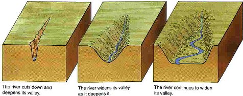
Describe how v-shaped valleys are formed
Vertical erosion occurs in the upper course of the river
Due to force of gravity scraping load along riverbed
This cuts down riverbed and deepens the channel
Weathering weakens the valley sides
Mass movement leads to material from the weakened valley sides collapsing into the river forming a steep v-shaped valley
River transports this material away, leaving behind steep valley sides
Describe how interlocking spurs are formed
Interlocking spurs are an erosional landform
In the upper course of a river, most of the erosion is vertical
This creates steep-sided v-shaped valleys
When the river encounters hard rock (in the spurs), it is not powerful enough to erode it, so are forced to wind around it
So high hillsides project into the valley from alternating sides as the river winds around them
Describe how meanders are formed
Meanders are formed by both erosion and deposition; they are bends in the river usually found in the middle course
Rivers have a helicoidal flow, meaning that the water travels fastest on the outside of the bend and travels slower on the inside of the bend
This means that more erosion occurs on the outside of the river bend, forming river cliffs
More deposition occurs on the inside of the river bend, forming slip-off slopes
Over time this creates bends in the river
Describe how ox-bow lakes are formed
Ox-bow lakes are formed from meanders
As erosion continues on the outer bend, the outer bends of a meander become closer
This leads to the formation of a meander neck
Eventually the river breaks through the neck (usually during a flood as there will be greater river discharge and thus more erosional power) and the river flows along the shortest course
The flow of water at entry and exit of the meander will be slower, leading to deposition
This deposition eventually separates the meander from the main river, creating the separate ox-bow lake
Describe how floodplains are formed
Flood plains are depositional landforms; they are flat areas of land that flood
As river flows, it erodes outer banks, widening the river valley
When a river floods, the water overflows onto the surrounding land
The water loses velocity, causing it to deposit some of its load
The deposition of sediment like silts make the floodplain fertile
Layers of sediment build up the river plain after each flood, increasing its height and creating a flat, fertile floodplain
Describe how levees are formed
Levees are depositional landforms; they are natural embankments
When a river floods, the water overflows onto the surrounding land
As the water loses its velocity, it deposits some of its load
The heaviest material is deposited closest to the river channel as it gets dropped first when the river slows down
Over time the deposited material builds up, creating levees along the edges of the channel
Describe how deltas are formed
Deltas are depositional landforms; they are plains made up of material deposited by a river at its mouth
When a river meets the sea or a lake, they are forced to slow down
due to increased friction and resistance from the standing water
This means that the water is forced to deposit the material that it’s carrying
If the material is not washed away (eg. by the sea), the layers of sediment build up
Deposits material faster than it can carry it away
This causes the main channel to become blocked, causing the river to split into many smaller channels (dstributaries)
Eventually the material builds up so much that low-lying areas of land (deltas) are formed
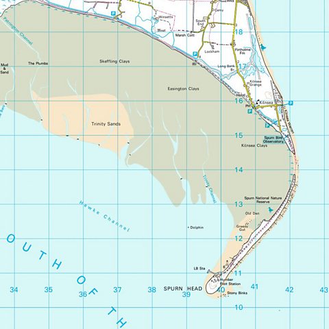
How to identify the direction that rivers flow from a map?
Rivers flow from high gradient to low gradient; using contour lines (the closer together the contour lines, the higher the gradient) and height values it can show the height of land and thus the direction of the river
How to give evidence that a river is in its upper/lower course on a map?
Upper course:
Nearby land is high
Waterfalls are marked on maps
River crosses lots of contour lines in a short distance (shows it has a steep gradient)
The river is narrow (thin blue line)
Counter lines are very close together, meaning that the valley floor is narrow
Lower course:
Nearby land is low
River doesn’t cross any counter lines, very gentle gradient
River meanders, ox bow lakes
River is wide (thick blue line)
Explain how physical factors impact river landscapes and sediment load
Climate, geology, slope processes
Climate:
Rivers in wetter climates have higher discharge as there is more water entering the river channel;
high discharge increases rate of erosion, adding more material to the river’s load
also shapes the landscape, forming v-shaped valleys in the upper course (vertical erosion) and wide, flat flood plains in the lower course (lateral erosion)
transportation increases as the river will have more energy to carry material
Stormy/ rainy climates increase weathering, which increase the river’s sediment load
Geology:
Rivers flowing through hard rock have a slower rate of erosion because hard rocks are more resistant; this means that the river will have a lower sediment load
Areas with softer rocks will experience more erosion, adding more material to the river’s sediment load
Waterfalls form when there’s a layer of soft rock over hard rock
Interlocking spurs form when softer rock is eroded first, leaving areas of harder rock sticking out
Slope processes
Mass movement can add large amounts of material to the river’s load
Steep slopes increase the movement of material down the slopes
Steep slopes encourage rapid surface runoff, leading to increased erosion and a higher sediment load
Gentle slopes slow down water flow, encouraging rivers to deposit their load
What do storm hydrographs show?
The changes in river discharge around the time of a storm
Explain the four features of a storm hydrograph
Peak discharge; highest discharge in the period of time
Lag time; the delay between peak rainfall and peak discharge
Rising limb; the increase in river discharge as rainwater flows into the river
Falling limb; the decrease in river discharge as the river returns to its normal level
Name and explain how physical factors can impact storm hydrographs (5)
Geology; water cannot infiltrate impermeable rocks, so this increases surface runoff which decreases lag time
Soil type; impermeable soils cannot absorbs as much water as permeable soils, so this increases surface runoff which decreases lag time
Slope; the steeper the slope the less infiltration (as the angle of the land forces the water to move faster, giving it less time to absorb) which increases surface runoff
Drainage basin type; circular drainage basins have shorter lag times as all points are roughly equidistant to the river, so water reaches the main river channel at the same time. Whereas, in a narrower basin, water from the far end of the basin takes a long time to reach the main channel
Antecedent conditions; previously wet or very cold conditions can increase surface runoff as the water cannot infiltrate saturated or frozen soil
What is a drainage basin?
The entire area of land where all precipitation collects and drains into
How do human activities change river landscapes which alter storm hydrographs
Humans can change land use by: urbanisation, deforestation
Urbanisation
Water cannot infiltrate through impermeable surfaces (eg. concrete, tarmac), so there is greater surface runoff
Gutters and drains quickly take runoff to rivers, which rapidly increases discharge, increasing peak discharge
Deforestation
Trees take up water from the ground and store it which reduces surface runoff; therefore cutting down trees increases surface runoff which causes more water to enter the river channel
Climate change
Led to more extreme and frequent weather events, meaning that antecedent conditions are usually saturated, so land cannot absorb as much rainfall leading to more surface runoff
Explain how physical factors and human activities have caused river flooding on a named river
Named river: River Tees
The River Tees is prone to flash flooding
Physical factors:
Surrounded by impermeable rocks (eg. shale), so water cannot infiltrate
Surrounded by high slopes in the upper course as it flows through a steep, V-shaped valley in the North Pennines
Source is in Pennines, high altitude so experiences frequent, heavy rainfall - antecedent conditions are usually also saturated
Human factors:
In the lower course, Tees Barrage built to control river flow to prevent flooding
Lower Tees estuary is very industrialised (river supports large scale production and chemical works), lots of impermeable concreted land, increasing surface runoff.
Also very urbanised with a large population (nearby large towns like Darlington and Middlesborough)
Sheep and cattle grazing in uplands, cause lots of deforestation — reducing interception and thus increasing surface runoff
Explain the reasons that the risk of flooding is increasing in the UK
Increased frequency of storms
More periods of wet weather mean that the ground is saturated; poor antecedent conditions make it more likely to flood
Increasing significance of intensive rainfall events can cause significant runoff, exceeding the capacity of the river’s drainage basin and causing the river to flood more extremely
Land use change
Urbanisation causes an increase in impermeable concrete surfaces, which cause rapid surface runoff
Deforestation, removing vegetation mean that water that would’ve been absorbed/ stored by plants now flow quickly downstream, increasing surface runoff
Lots of development on flood plains, as there is an increase in people living near there it means that there is an increasing flood risk to more people
Explain the threats of river flooding to people
People can be killed or injured by floodwater
Roads, bridges, train lines can be damaged or destroyed
Floodwater can become contaminated with sewage, leading to a lack of clean drinking water
Homes can be damaged or destroyed, causing people to become homeless
Businesses can be forced to shut down because of flood damage and disrupted power supplies, leading to a loss of livelihoods
Explain the threats of river flooding to the environment
Floodwater can become contaminated with sewage, damaging wildlife habitats
Floodwater can become contaminated with rubbish and litter, polluting rivers and wildlife habitats
The force of floodwater can uproot trees and plants, damaging the plants and the surrounding ecosystem
River banks can become eroded, causing an increased risk of future river flooding and leading to huge changes to the river landscape, which can damage habitats
Name the hard engineering techniques for river management
Flood walls
Embankments
Flood barriers
Dams and reservoirs
River straightening and dredging
Give the benefits and costs for hard engineering for river management
Flood walls, embankments, flood barriers, dams and reservoirs, river straightening and dredging
Flood walls
Benefits:
Increase the height of river banks, allowing the river channel to hold more water
Long lasting and durable
Costs:
Very expensive
Unsightly
Block the view of and access to the river
Increased flood risk downstream
Embankments
Benefits:
Stop the river from flowing into built-up areas when the river floods, protecting buildings and infrastructure — by increasing river capacity
Can be made from Earth or other natural materials, making them less unsightly
Costs:
Expensive
Increased flood risk downstream
Required maintenance
Flood barriers
Benefits:
Prevent the river from flooding
Permanent flood barriers can open and close, allowing the river to flow naturally when it is not flooding
Can be de-mountable, so only used when needed, not disrupting visually/ the environment at all times
Costs:
Permanent flood barriers are very expensive
Permanent flood barriers need constant maintenance
De-mountable flood barriers may not be put up in time
Dams and reservoirs
Benefits:
Provides reliable water supply
Hydroelectric power
Water can be held back during rainfall, preventing river flooding downstream
Can be used for recreation and tourism
Costs:
Very expensive to build and maintain
Environmental damage
Flooding land to form reservoirs destroys habitats and ecosystems
Reservoirs may displace people
May be visually unappealing
River straightening and dredging (making it deeper)
Benefits:
Reduces flood risk locally as there is faster water removal from an area
Improved navigation for boats
Costs:
Increased flood risks downstream
Increased erosion (as moves faster with more energy)
Environmental damage (eg. meander habitats are destroyed)
Artificial and unnatural look
Name the soft engineering techniques for river management
Flood plain retention
River restoration
Afforestation
Give the costs and benefits of soft engineering for river management
Flood plain retention
Allows floodplains to naturally flood, restricting building developments in these areas to reduce flood risks downstream
Benefits:
Helps slow the floodwaters down and maintain the flood plain’s ability to store water
No money has to be spent on building flood defences
Allows natural ecosystem to remain natural and thrive
Costs:
Restricts development on that area
Cannot be used in urban areas
River restoration:
Returns altered rivers to their natural state
Benefits:
Restores natural habitats, allowing the ecosystem to thrive and encouraging biodiversity
Very little maintenance required
Improves water quality
Reduces flood risk (by allowing flood plains to restore and work to absorb water naturally)
Improves natural visual aesthetics
Costs:
High initial costs
May lead to a loss of land (for urban/ industrial use), which can lead to land conflicts
Can increase flood risk if nothing is done to prevent major flooding
Afforestation
Benefits:
Reduces surface runoff by increasing interception and infiltration, lowering flood risk
Environmental benefits
Costs:
Takes a long time to be effective and trees take a long time to grow
Land use conflict
Limited impact in extreme floods as soil can become saturated
Explain one reason why sedimentary rocks are usually eroded faster than igneous rocks.
More bedding planes/joints (1) so more access for water etc. (1)
Chemically less resistant to solution (1) for example chalk and limestone s (1)
Suggest one reason why only a small percentage of the Scottish coastline is being protected.
Much of the coastline is made up of hard, resistant rocks (1) so erosion rates are very low without protection (1)
Much of the coastline is very lightly populated (1) making protection expensive and pointless (1)
There is a great deal of coastline to protect (1) so only a small proportion is likely to need and/or warrant protection
Explain how coastal erosion processes create cliffs.
Waves erode the coastline with hydraulic energy and abrasion (1)
exploiting weaknesses in the structure of the rocks (1)
leading to the undercutting of the cliff (wave cut notch)(1)
leading to rockfall and/or slumping due to gravity (1)
development of cliffs and their retreat over time (1)
these processes can be exacerbated by weathering (1)
If asked about the shape of the river valley, what should you refer to?
Gradient
Shape
of the land either side of the river channel
Name the four types of coastal management policies
Hold the line
Advance the line
Do nothing approach
Includes leaving current management
Strategic realignment