Earth Science Test #4
1/201
There's no tags or description
Looks like no tags are added yet.
Name | Mastery | Learn | Test | Matching | Spaced | Call with Kai |
|---|
No analytics yet
Send a link to your students to track their progress
202 Terms
Stream
water flowing downhill due to gravity confined to a channel
(rivers, streams, creek, etc. = streams)
Hydrologic Cycle
illustrates the circulation of Earth’s water supply
Precipitation
material falling to the ground because of gravity
(rain, sleet, snow, etc.)
Infiltration
seeping into the ground
Evaporation
process of a liquid turning into a gas
Transpiration
water moving through plants
(also called evapotranspiration when it evaporates from the leaves)
Runoff
water moving across the surface
Condensation
gas turning into a liquid
Meandering Stream
meanders through the landscape; soft material
Braided stream
multiple sections confined to one channel; glacial or mountain areas
Tributary
smaller stream that flows into a larger stream
What are the parts of a stream?
stream bed - the bottom of the stream
channel - where the water is
banks - the edges of a stream
head - start of stream
mouth - end of stream
Drainage basin
land area that contributes water to a river system
Drainage divide
separates drainage basins (a high spot that divides drainage basins)
ex: Continental divide - divide in the U.S. and Rocky Mountains
Gradient
also called slope
Discharge
volume of water flowing in the stream
(generally expressed as cubic feet per second or cubic meters per second)
Dissolved load
ions dissolved in the stream; not solid
Suspended load
solid particles floating in the stream
Stream load
transported material is called this
Bed load
solid material in contact with the stream bed
Traction
sediment that rolls along the stream bed
(ALWAYS in contact with the stream bed)
Saltation
sediment that skips along the stream bed
(SOMETIMES in contact with the bed & sometimes not)
Competence
maximum particle size
Capacity
maximum load
Deposition
sediment that is not being moved
Delta
sediment deposited when a stream flows into another body of water
in a fan shape
generally sand
Alluvial fan
sediment deposited when a stream flows on to a flat surface
(not in water ex: flows down a mountain to a valley in a dry climate)
in a fan shape
Natural levee
sediment deposited as a stream overflows its channel
form parallel to the stream channel
Base level
lowest point a stream can erode to
Floodplain
area adjacent to the stream that typically floods
Meander
curves in the stream
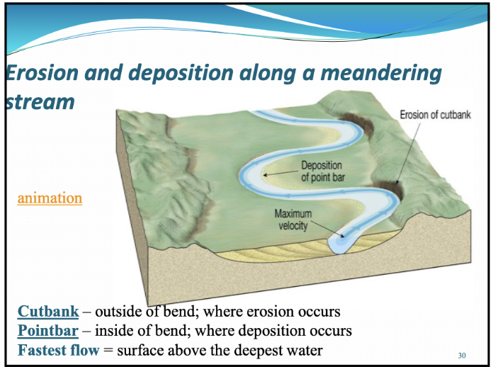
Cutbank
outside of bend
where erosion occurs
Pointbar
inside of bend
where deposition occurs
Oxbow lake
cutoff meanders filled with water
Meander scar
cutoff meander not filled with water
Flood
when a stream overflows its banks
Hydrograph
it shows stage measuremnets for the gauging station
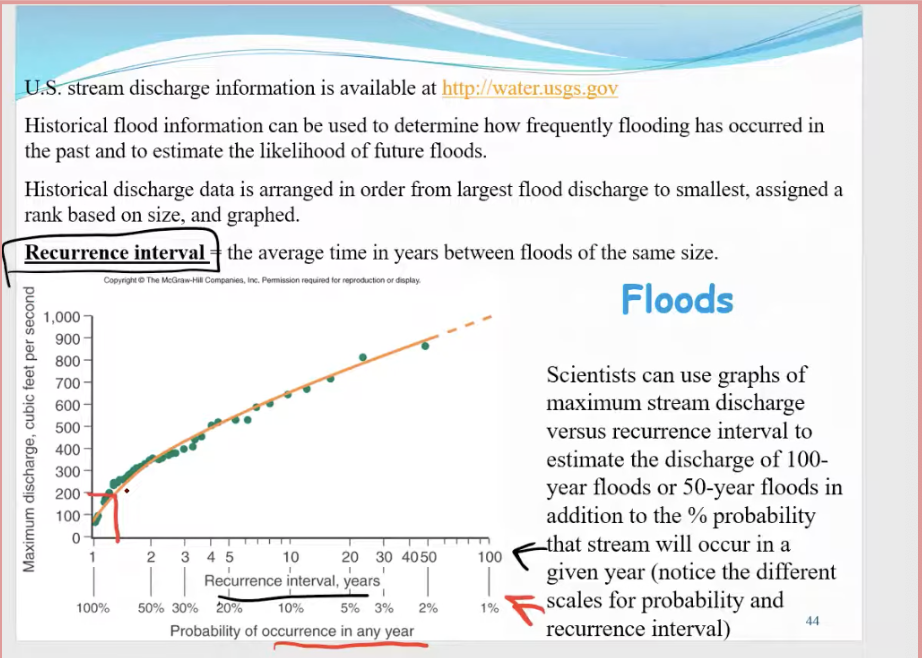
Recurrence interval
the average time in years between floods of the same size
Groundwater
water beneath the surface
(largest liquid freshwater reservoir for humans)
Sinkholes
surface depressions that are formed by dissolving bedrock and cavern collapse
Caverns
caves formed by dissolving rock beneath Earth’s surface; formed in the zone of saturation
Zone of aeration
pore spaces in the soil material are filled mainly with air but can have some water, especiallly after a rain event
Unsaturated zone
another word for zone of aeration
Zone of saturation
all pore spaces in the material are filled with water
(water within the pores is groundwater)
Water table
the upper limit of the zone of saturation
Porosity
percentage of pore spaces
Pore space
spaces between particles, like the space between individual sand grains
Permeability
ability to transmit water through connected pore spaces
the interconnectedness of pore spaces
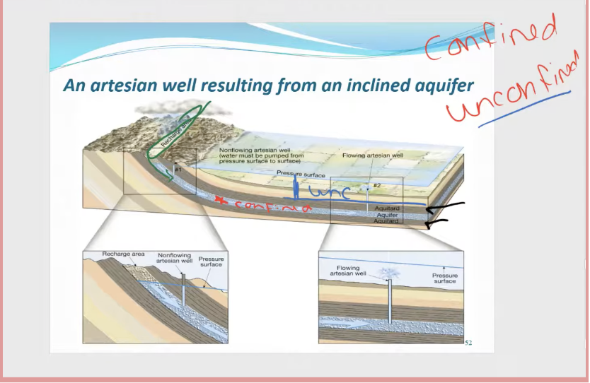
Aquifer
permeable layer
high porosity and high permeability
Ex: sandstone, conglomerate, limestone, highly fractured igneous or metamorphic rock)
Aquitard
impermeable layer
low permeability and porosity
Ex: shale, unfractured igneous or metamorphic rocks
Confined aquifer
confined between two aquitards
very limited area at surface to be refilled by rain events
most water in these were put here during the last glacial period
Recharge zone
area at the surface where water infiltrates the aquifer by rain events
Unconfined aquifer
open to the surface that can be refilled by rain events
Artesian well
water in the well rises higher than the initial groundwater level (under pressure)
Perched aquifer
suspended above the water table
also known as a false water table (because water will “run out” for wells drilled here)
Hot springs
heated by cooling of igneous rocks or magma beneath the surface
Geysers
intermittent hot springs
Ex: Old Faithful in Yellowstone National Park
Saltwater intrusion
when salt water gets into a groundwater source
a well near the ocean can cause unwanted saltwater to come up into the well since freshwater is less dense than saltwater
Groundwater overdraft
This has caused a drop in the water table of up to 70 meters
(The Ogallala Aquifer case study)
Drawdown
lowering of the water table (like sucking water up a straw)
Cone of depression
the larger the well, the larger this is.
Land Subsidence
caused by its withdrawal
(land compacts when it no longer has water &.will no longer hold as much water as it did before)
Karst Topography
terrain formed by dissolving rock at, or near, Earth’s surface
(sinkholes, caves, or caverns, etc.)
Point source pollution
can tie back to a specific place
Ex: a chemical factory leak, an oil spill from a tanker, etc.
Nonpoint source pollution
cannot tie back to a specific place
Ex: nutrients from farmland, oils from parking lots, etc.
What is the hydrologic cycle?
The total amount of water is the same, it is just recycled throughout the world.
How is water proportioned on earth? (e.g. how much freshwater vs saltwater; how much. is in glaciers, groundwater, etc.)
Freshwater is a tiny percent of water on the planet
Oceans make up 97.2% of the hydrosphere
Glaciers are 2.15%, and that is freshwater
Groundwater is 0.62%, which is the greatest quantity of liquid water
What factors affect a stream?
gradient, or slope
channel characteristics -shape, size, and roughness
discharge
How do streams erode?
sediment rushing downstream, driven by high-speed waters volume, and slope cause the stream to deepen and widen overtime
In what directions do streams erode?
Streams can erode laterally, vertically, and toward the headwaters
What is the relationship between stream velocity and particle size?
Bigger particles slow down the stream as opposed to streams with less particles
How does a river change downstream?
It becomes wider, deeper, and faster as it gains water from tributaries
Where is the fastest flow in a stream?
Surface above the deepest water
Be able to label the parts of a meandering stream:
Meanders – curves in the stream
• Cutoff meanders – no longer attached to the stream
• Oxbow lakes – cutoff meanders filled with water
• Meander scar – cutoff meander not filled with water
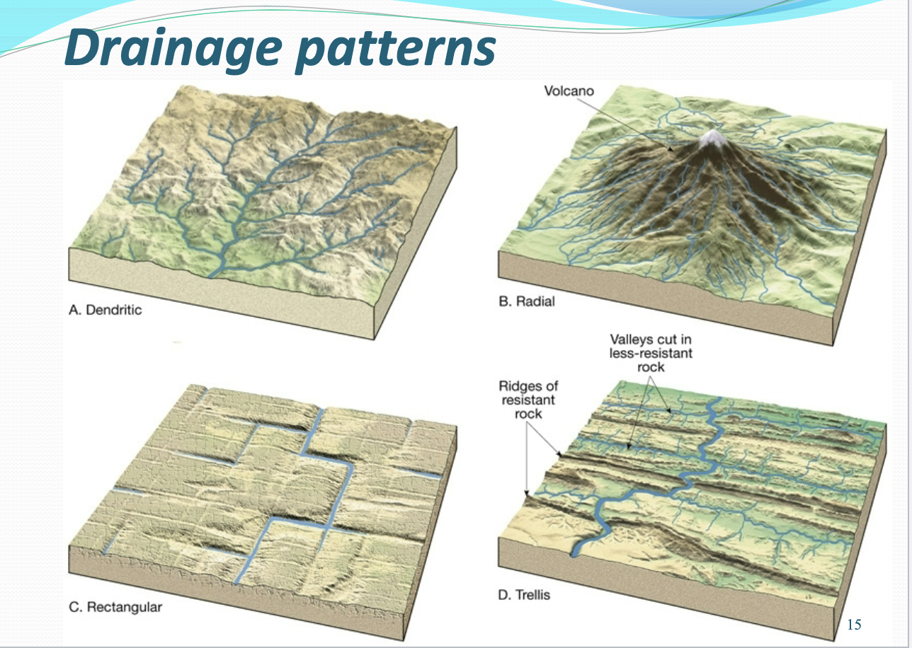
Describe the different types of drainage patterns:
Dendritic - many tributaries connecting to a mainstream channel; resembles a tree; typical of flatter areas with softer material (easily eroded in any direction)
Radial - streams originate from one central location; typical of mountain or volcano tops
Rectangular - streams that meet at near right angles; typical of highly fractured rock areas
Trellis - tributaries that form parallel to one another; typical of areas confined by mountain ranges or ridges (streams are in the valleys)
What are some ways we can control floods?
artificial levees
Flood-control dams
Channelization
Sound floodplain management (constructed wetlands, for example)
Be able to determine the recurrence interval and probability from a graph:
Explain the conditions that make material a good aquifer:
Needs to be a permeable layer, high porosity and high permeability
What material/rocks make good aquifers?
Sandstone, conglomerate, limestone, highly fractured igneous or metamorphic rock.
What material/rocks make good aquitards?
Shale, unfractured igneous or metamorphic rock
Be able to label an unconfined aquifer, aquitard confined aquifer artesian well, and a recharge zone on an image:
Why is subsidence a huge concern?
Because once you draw water out of land, it will no longer hold as much as it did before. This causes flooding, sinkholes, and damage to infrastructure.
How have humans altered groundwater?
They have caused land to subsidise contaminated groundwater through agricultural and industrial activities, and treated it as a renewable resource even though it is not a renewable resource.
What is the Ogallala Aquifer?
It is one of the largest underground freshwater resources in the world!
What are the major concerns for the Ogallala Aquifer?
unsustainable depletion due to excessive agricultural pumping, which far exceeds the natural recharge rate
Why is the Ogallala Aquifer significant?
It provides water for 82% of the 2.3 million people in the High Plains area and irrigates over 30% of U.S. crops and livestock, transforming the region into an agricultural powerhouse.
How do caves form?
They form by dissolving rock beneath Earth’s surface, and are formed in the zone of saturation.
What features are found within caverns?
A: stalactites (hanging from the ceiling) and stalagmites (growing upward from the ground) - both of these formations are composed of dripstone
Chapter 9 Scripture
Ecclesiastes 1:7 - “All streams flow into the sea, yet the sea is never full. To the place the streams come from, there they return again.
Glacier
a thick mass of ice that forms over land from the compaction and recrystallization of snow and shows evidence of past or present flow.
Crevasse
form in brittle ice - very large fractures in the ice
Zone of accumulation
the area where a glacier forms
(material is being added to the glacier)
Zone of ablation
the area where there is a net loss due to melting
(also called the zone of wastage)
Plucking
lifting of rock blocks out of the ground
Rock Flour
(pulverized rock)
makes glacial lakes look opaque or cloudy
Striations
(grooves in the bedrock)
basically like scratch marks that indicate the direction of ice flow.
It is impossible for a piece of rock in the ice to leave a scratch perpendicular to, or any direction other than, the direction of ice flow.
Till
material that is deposited directly by ice
poorly sorted,
loose sediment
Stratified drift
sediment deposited by the meltwater of a glacier
Fjord
a glacial trough now filled with water
forms when a glacier flows into a large lake or ocean
Horn
high point where cirques and arêtes meet