ess w8 l2 pt 1 - past landscape responses
1/33
Earn XP
Description and Tags
terrestrial sphere
Name | Mastery | Learn | Test | Matching | Spaced | Call with Kai |
|---|
No analytics yet
Send a link to your students to track their progress
34 Terms
Climate cycles – past:
Climate controls landscape evolution through:
Land surface temperature and rainfall affects processes and rates
Sea level affects energy and form of rivers, deltas and shelves
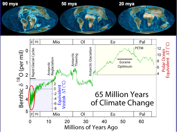
Changes in sea level over time
Shows how theres been a significant change in warmth of earth – wsrmest time = ecocene optimum
Up to 12* warmer than today
End of extended interglacial
Focusing on the red for this lecture
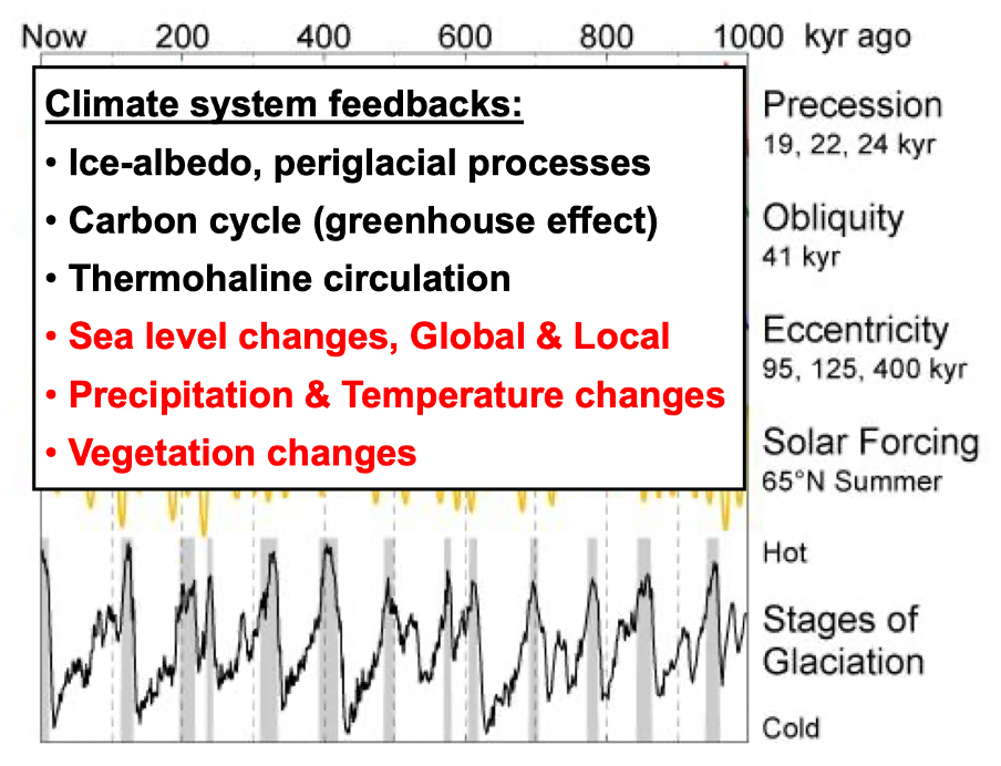
Sums up different drivers than run the glacial cycles
Has been lots of change sparticularly last million years – how landscpa responsds is driven by the red processes
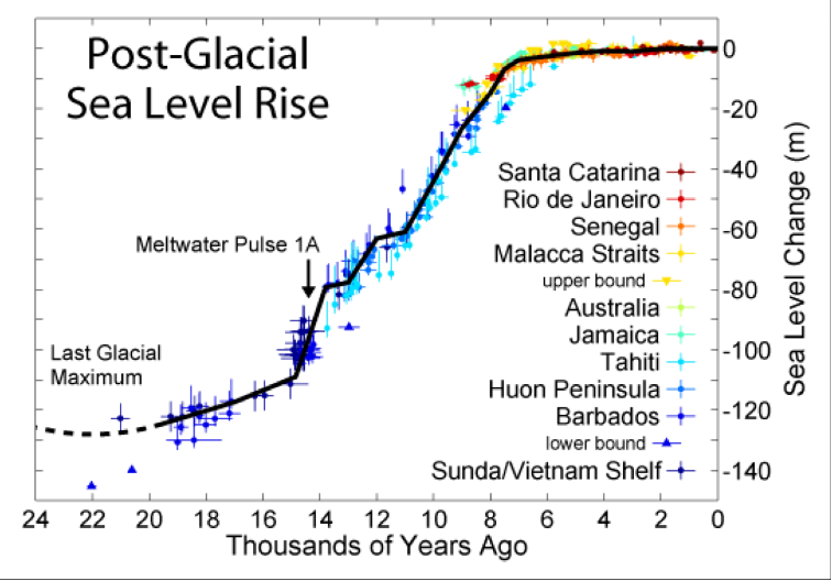
125m rise of sea level
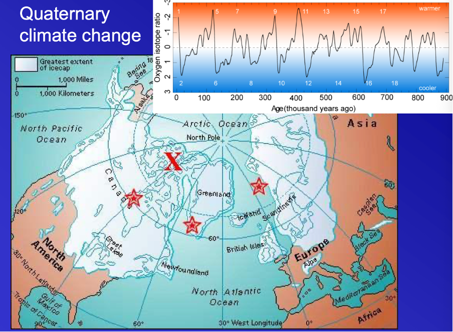
Quaternary climate change:
Shows extent of the ice sheet
Especially north America/ then northern england
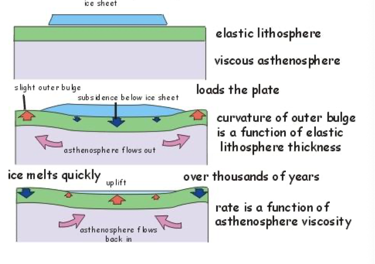
Model for post glacial rebound:
The glacial sheets reuslte din crust being pushed downwards due to its weight
When weight removes – the material flows backwards
Process takes tens of thousands of years as moves slowly
Effects most dramatic in poles but significant fluxing elsewhere – particularl biggest rivers. Changing of a few metres makes a bog difference as theyr eon a low gradient
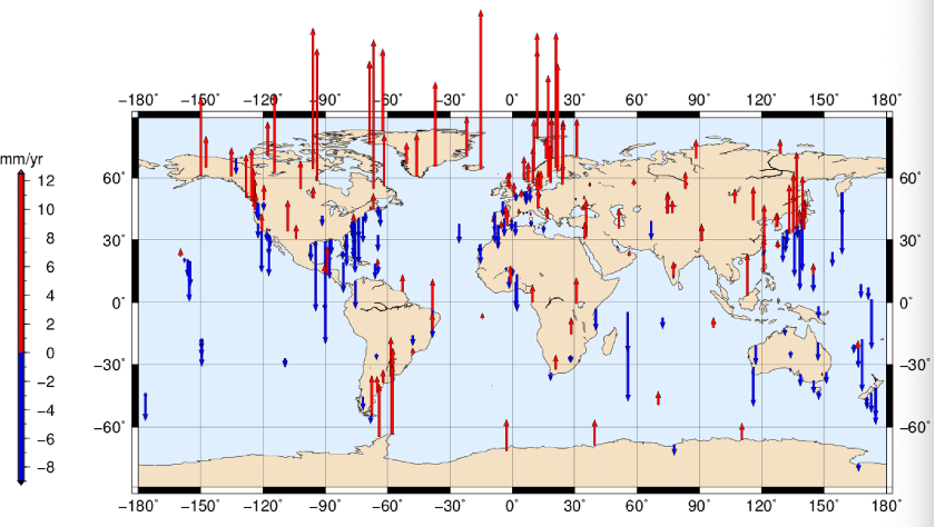
Global glacial-isostatic adjustment: some regions rise, others fall:
Global map of vertical movement from provided by GPS surveys (avoiding areas of active tectonic deformation)
Tallest bars approx. 1cm/ year
Blue arrows – many places where things are sinking due to: ice melted – where did water go (12m equivalent went into the oceans – adds lots of weight. Pushes down oceanic crust and the masisve weight makes lower lqatitudes an dequitoiral sink duw to additional ocean mass around). And as asthenosphere migrated to where weight moved – come from ages where there wasn’t a change – results in sinking
All this adjusting impacts the fluvial processes
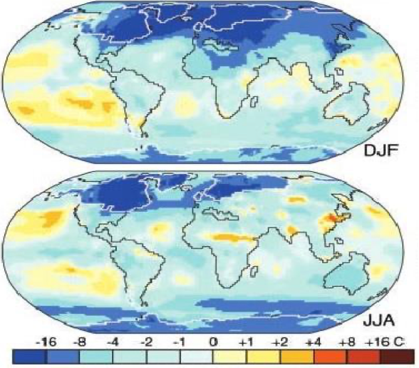
Temperature changes: last glacial maximum vs now:
Also difference of December- feb to June-august
There were regions of tropics that were warmer compare dto today – come areas got a bit colder
Greatest impact in poles
Local changes important to pattern in rainfall
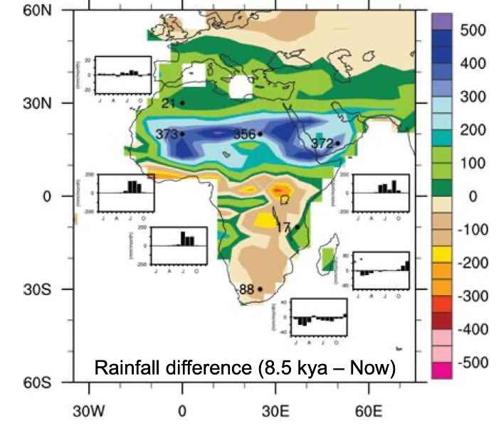
Africa – early Holocene compared to today
Based on sediment cores around Africa
How wet it was based on sediment deposits
Shows larger chunks of sahara desert/ saha – were much wetter than now
These wetter environment weres recorded in art
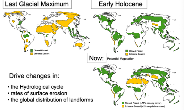
Global vegetation change:
During last glacial max – much less vegetation – impacts the changes
Landscape evolution:
Shorter term deviations from longer term progressive landscape lowering
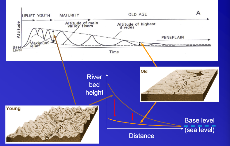
WM Davis ‘cycle of erosion’:
Shows steady change in the model but more usual to have interruptions in the process
Terraces – periods hwere the rivers were degrading – with step ups – shows past floodplains
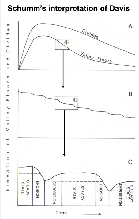
If take the davis view of a steady way – if zoom in can see its not a smooth line – there will be hiccups – come down quickly/ slow down etc.
See there’s depositions events – steady states – erosional event (whole system erodes down a but more ) – there are cycles in the process
River terraces:
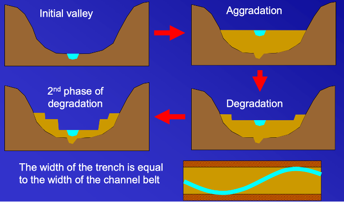
River terraces are formed by alternating periods of erosion and deposition (cut and fill)
Initial valley then increase in sediment beyond what it can carry - so deposition
2nd phase – cut donw futher and more degraded
Multiple incision events
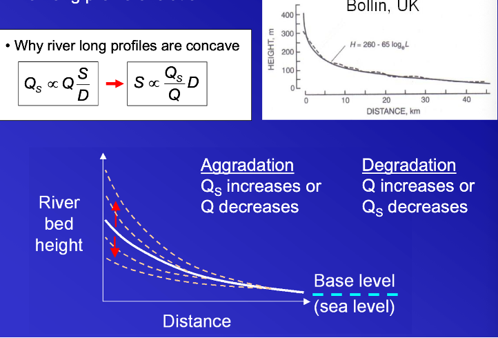
River long profile evolution:
Occurs due to lane equation
Concave shape as sediment discharge declines more rapidly than water discharge
Ultimately the processes lead to periods of aggradation and degradation
Two conditions of the ystsme lead to river channel either coming up (seidmnet increase. Degradation inverse – brings everyting donw but aggradation makes it steeper
The process construct a lot of landscape features
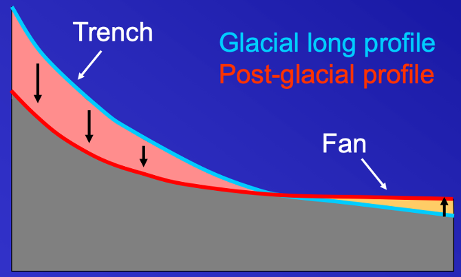
Glacial cycles and long profile change:
During glacial periods upland glaciers scour the landscape and supply abundant coarse material to pr-glacial braided rivers
This sediment enters storage within braidplain deposits – and this is then remobilised during interglacials
During interglacials – warmer – starts to have incisions and terraces
New Zealand – lower sea levels but very long continental shelf – as have lots of space
Remobilisation involves the cutting of a trench – sediment cut from the trench is deposited downstream as a fan

Fluvial knickpoints (waterfalls or rapids):
Very sharp section of the profile
Dramatic examples = waterfall
Knickpoints repsrsent how channel longprofiles change
Doesn’t change immediately
Migration of steep portion migrating upstream
Actions occurs on the steep part. – erosion occuirng.
How the processes adjust themselves over time
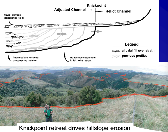
Started 20,000 years ago
Erosional profile making its way up to main channel and the tributaries to the fltter area
This erosion is driven by increased local erosion potential
Positive feedback mechanism
Environmental archives:
Do landscapes and sediment deposits provide a reliable archive of environmental change?
Floodplains as of archives of environmental change:
Sediment deposits provide a record of past environmental conditions
To make use of such deposits we must understand the relationships between environmental change and landscape response
Particularly with types of dating e.g. radiocarbon
Work out how old portions of the floodplain are
Understand how changing landscape reflects conditions fo how it formed
How should we interpret landforms in order to reconstruct past environmental change:
Is this evidence for changing water and sediment supply?
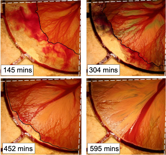
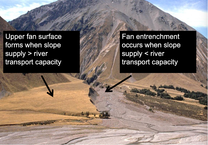
Laboratory study of fan evolution:
Supply a consistent known amount of sediment
Dyed water red – more red= deeper water
Work out depoth of flow across the fan
As fan surface progresses over time – infilled the space
Sediment deposited in the little channels concentrating the flow into one deep channel
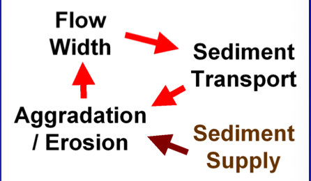
Process-form feedbacks on evolving fans:
Move down fan from top to bottom – sometime there’s water everywhere (maximum width) but there’s a slight decrease in width of surface that wet as move down the fan
Flow is increasingly concentrated in to 20% or less of area
Flow width depends on whether or not flow deposits. Sediment and expands the fan
Implications for landscape interpretation?
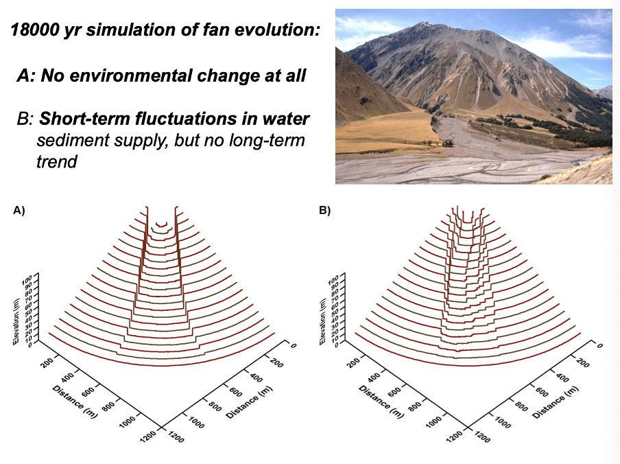
Incisions process driven by fan taking up all availbel deposition spaces. If have fluctuations will get terrace features and an incised fan too
Causes of fan entrenchment:
Paraglacial decline in sediment supply
Product of difference between slope and river sediment transport regimes
Process-form feedbacks
Autogenic behaviour from internal form
Equifinality:
When different processes or environmental conditions can produce the same landform
Summary:
Climate cycles affects ice volume, sea level, and isostatic response, along with local precipitation and vegetation
Glacial cycles and associated eustatic and isostatic responses have impacts on sea level, coastline position and coastal landforms
Past changes in climate and vegetation drove changes in hydrological processes, erosion and sediment delivery to rivers
River terraces represent former long-profile (valley floor) positions and provide evidence of phases of aggradation and incision
Landscape rejuvenation (incision) can also be driven by tectonic uplist and relative base level change (including sea level), creating knickpoints
Landforms and deposits that result can emerge either from external forces of environmental change or internal (autogenic) system responses to geometric constraints or process-form feedbacks. Models are a way to explore these different scenarios to best interpret environmental archives