UNC GEOG120 FINAL EXAM STUDY GUIDE
1/75
Earn XP
Description and Tags
Latin America + North America Units
Name | Mastery | Learn | Test | Matching | Spaced | Call with Kai |
|---|
No analytics yet
Send a link to your students to track their progress
76 Terms
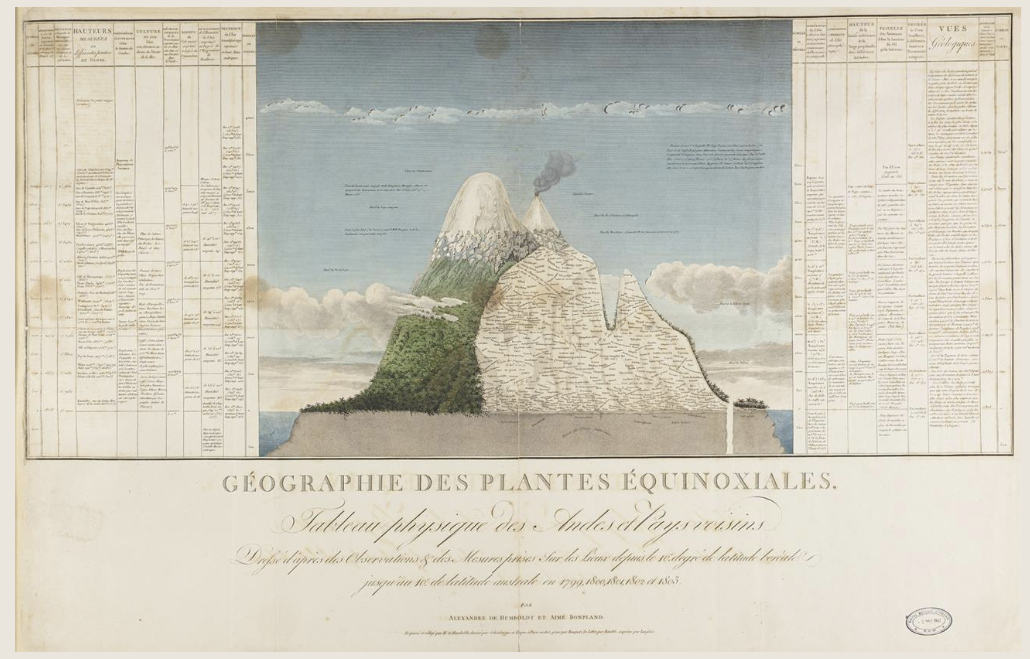
Alexander von Humboldt’s Tableau Physique (1807)
Oldest existing dataset on altitudinal ranges of tropical mountain vegetation. Detailed observations of the altitudinal plant distribution of plant species in the equatorial Andes, depicted on a cross-section of Mt. Chimborazo, allowed establishment of the concept of a vegetation belt.
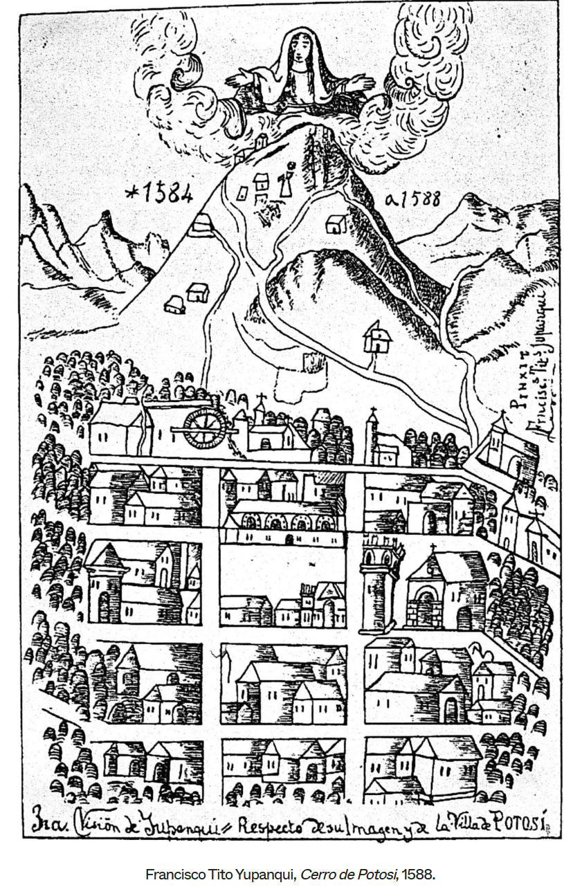
Cerro de Potosi Map by Francisco Tito Yupanqui (1588)
The site of the largest Spanish mine in the Americas. The Virgin of Copacabana, long associated with the mountain, is pictured at the summit.
Altitudinal Zonation
Tierra Caliente (0-3,000 ft) → Sugarcane, bananas, yams, maize, rice, poultry, cattle
Tierra Templada (3,000-6,000 ft) → Coffee, maize, coca, tomatoes, melons, cut flowers, dairy, cattle
Tierra Fria (6,000-10,000 ft) → Wheat, barely, maize, potatoes, apples, sheep, guinea pigs, llamas, alpacas, vicuna
Tierra Helada (10,000+ ft) → highland grains & tubers, sheep, guinea pigs, llama, alpaca, vicuna
1492
The arrival of Christopher Columbus in the Americas
Treaty of Tordesillas of 1494
Signed by Spain and Portugal, it was a pivotal agreement that divided newly discovered lands outside Europe along a meridian, granting Portugal lands to the east (including Brazil), and Spain lands to the west. The line was signed into decree by the Pope, to reflect a settlement by Spain and Portugal as the great imperial powers.
Catholic Church was the highest authority. Both countries wanted to be legitimized with the Pope’s blessing.
Portuguese Colonization
Had a very global outlook and were the leaders of navigating around Africa. They set up trading posts and ports, and were big into the slave trade. They had territories in South Asia. Brazil was part of their integrated empire.
Spanish Colonization
Focused more explicitly on colonizing the New World in pursuit of God, Gold, and Glory. The flooding of precious metals from the Americas into the market caused concerns for inflation.
Columbian Exhcange
Began in the 1500s, and was the massive two-way transfer of plants, animals, diseases, people, technology, and ideas between the Old World and the New World.
Native Americans had no genetic resistance to European diseases. Around 75%-90% of Indigenous people died.
Diseases include smallpox, influenza, typhus, measles, malaria, diphtheria, and whooping cough
From Americas to Old World = potatoes, maize, cassava, tomatoes, cocoa, tobacco
From Old World to Americas = horses, cattle, pigs, sheep, wheat, sugar, coffee (caused overgrazing, soil erosion, and deforestation)
Pests brought over include weeds, rats, cats (competed with local species)
Triangular Trade
Middle passage of slaves from Africa transported to Latin and North America. Sugar from Latin America in the form of rum was transported to Europe. Gun manufacturers transported from Europe to Africa.
Colonial Transformations:
Biological conquest and Native population decline
Land tenure → How was land controlled, used, and owned? Rights to land ownership? Distribution of land?
Latifundia // Haciendas
Spanish estates where a variety of crops were grown both for local and international markers. Because of the variety, workers lived on the land, unlike the seasonal laborers needed to work plantations. The size of the hacienda increased the social standing of the landowner, and hacienda farmers were often given their own plots of land to cultivate.
Minifundia
Smaller land-holdings or sharecropping on land held by others. Part of a feudal society where land ownership = prestige
Latin American Urban Legacies
The most urbanized continent, a part of Spanish culture left behind from colonization. The vast majorities of cities are located on the outskirts of the continent. 50%-90% of the population lives in megacities.
Mexico City = 18-20 million
Sao Paulo = 18 million
Buenos Aires = 12 million
Rio de Janeiro = 11.5 million
Urban Primacy
A city is more than twice as large as the next largest city
Cuadrícula
The idealized layout and land uses in a colonial Spanish town. It consisted of a system of streets and blocks that were laid out with precision, and was usually structured in a hierarchical fashion with the “main plaza” as its focal point, since it symbolized the city center. It was adopted as the standard form for creating cities, and was characteristic of all town planning projects carried out in the New World.
Creole
a person of mixed European and Black descent, especially in the Caribbean
Pre-Colonialism and Colonialist Societies in Latin America (Overview)
Pre-Colombian societies were decimated by the practices of colonialism and by European diseases (est. ~75%-90% population decline)
Culture, religion, language, and political-legal systems (including land tenure) in Latin America were heavily influenced by Spanish & Portuguese, but also by Indigenous peoples, Africans, and other Europeans
South America’s population is concentrated on the coastal periphery of the continent
Indigenous cultures persist primary in the highland (Tierra Fria + Terria Helada) regions, as well as in the Amazon Basin interior
Leading demographic trend is rural-urban migration
Mexico: The Zapatistas
Their primary goal was land reform and redistribution. They also demanded great political and cultural autonomy for the Indigenous people of Chiapas and there rest of Mexico. The main impetus for the rebellion was a series of economic reforms introduced by the Mexican government that were intended to prepare Mexico for integration into the NAFTA
North American Free Trade Agreement of 1994 (NAFTA)
A pact between the US, Canada, and Mexico that created a massive free-trade zone, eliminating most tariffs and barriers to boost economic integration, but it was controversial for job impacts and was replaced by the USMCA in 2020
United States-Mexico-Canada Agreement of 2020 (USMCA)
Replaced NAFTA. The Agreement creates more balanced, reciprocal trade supporting high-paying jobs for Americans and grow the North American economy.
Protest Space: Madres de Plaza de Mayo (Buenos Aires, Argentina)
A Argentine human rights movement founded in 1977 by mothers whose children were “disappeared” (forcibly abducted) by the military dictatorship during the “Dirty War,” who peacefully marched wearing white headscarves to demand answers about their missing loved ones. They became powerful symbols of resistance, fighting for truth, justice, and democracy
Latin American City Model
Central Business District (CBD): Located in the center of the city often alongside a central market. Cities typically still have a large plaza area in the CBD.
Spine: Connects the CBD to a major retail area or mall
Elite Residential Sector: Surrounds the commercial area of the spine, consisting of housing for the wealthiest residents of the city, often in high-rise condominiums
Zone of Maturity: An area of middle-class housing.
Zone of Sit Accretion/Transition: A transitional area from the modest middle-class housing to the slums of the city’s poorest residents
Zone of Peripheral: Squatter settlements where residents do not own or pay rent, and instead occupy otherwise unused land.
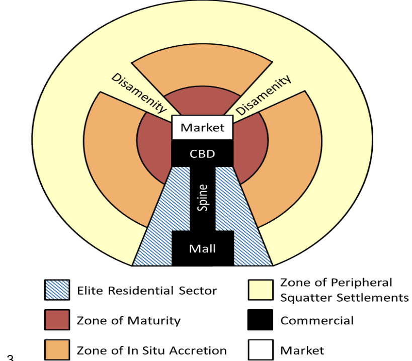
Informal Sector
Where goods and services are bought and sold without being taxed or monitored by the government
Making Space in Brasilia
Built from 1957-1960, it was a monument to modernity and a new vision of Brazil. It’s a capital built from scratch. It’s designed to push the country into new territories, opening up the Amazon into economic development
Deforestation
the clearing of trees and other biotic features from the land, turning a forest into a different of ecosystem
Key Causes and Consequences of Deforestation
Production of new lands for commercial and subsistence agriculture
Cattle ranching
Cash crops → The Soy Frontier accelerating deforestation in Brazil
Production of commercial products (especially timber)
Subsistence → gathering fuelwood & agriculture, but on a smaller scale
“Slash and Burn” Agriculture
An Indigenous method of agriculture where they torch a section of land and the burned material becomes a natural fertilizer in the area. They grow things on the land for a few years, and then move onto the next area. It tends not to be destructive on a large ecological scale.
“Fishbone” Deforestation Patterns
The cheapest way a state can open up a region is to lay down the main road. Once the initial road is laid, all of the people who are trying to claim land now have access.
Part of “Generic” landscape development
Amazon Deforestation
What’s the problem? → soil degradation, loss of biodiversity, contributions to climate change
State Project?
Ecuador and land reform
Brazil and state subsidies
Alternatives? Extractive reserves?
MST: Landless Peasants Movement in Brazil
contains about 500,000 families in 4,000 settlements in Brazil. They are taking advantage of the law, where they are squatting on unused lands held by big land owners. They go in the night and set up rudimentary barracks and begin farming on it in an attempt to claim it. Sometimes it works, but sometimes the landowners try to clear them off.
Extractive Reserves
Indigenous communities have rights to extract resources from their lands but its not large scale
Cultural Politics of Technology In Chimborazo, Ecuador
This is an area of large Indigenous population. Agencies interested in helping the Indigenous populations here to create survivable futures. NGO, the government itself, the Catholic Church, sent agents to support these people. Created Indigenous Federations, gave them limited autonomy. Federations were a voice for Indigenous communities to communicate with outside groups. It promoted their rights as citizens of Ecuador, and also protected their cultural rights.
Indigenous Technological Knowledge (ITK)
They don’t want to only use modern technology, they also want to go back to traditional ways of agriculture. The federations often rejected it and they weren’t very successful. Many of them were already integrated into market agriculture, so the idea of going back to traditional labor was overly romanticized, and they associated it with being peasants and a colonial context.
Runas
peasants
Road Warriors in Bolivia
Women building a road block near La Paz. Coca leaf farmers were protesting the government’s destruction of nearly all of their crop, which is used to produce cocaine.
Geography can be split into stages of cocaine production.
Trends in Contemporary Latin American Geograhies
Primary exports of the region: coffee, bananas, and tropical fruits, oil and minerals, and livestock products; illegal drugs
Oil economies: offshore in Caribbean (Venezuela; Colombia; Mexico), Ecuador interior (Oriente)
Large disparities between rich and poor (social geography)
Wide political disparities: left-right, democratic-authoritarian
Prohibition Era (1920-1933)
Alcohol was illegal in the US, and it could not be produced or served
Tijuana, Mexico
Emerged as a “sin city” and it became known for its night life and resorts. The Hotel Caesars are where the caesar salad was born. During the prohibition era, many people from the US visited here for alcohol and entertainment.
Trans-border Articulations
Bracero Program (1942-1964)
Border Industrialization Program (1965)
NAFTA (1994-2020) → USMCA (2020-present)
Bracero Program (1942-1964)
a U.S.-Mexico agreement that brought millions of temporary Mexican laborers (braceros) to the U.S. to fill agricultural and railroad labor shortages during and after World War II, offering short-term contracts, basic labor protections (like minimum wages and housing), but often resulted in exploitation, low pay, and harsh conditions, sparking labor movements and influencing modern immigration debates.
Border Industrialization Program (1965)
a Mexican initiative started in the mid-1960s to create jobs and stimulate industrialization along the US-Mexico border. It attracted foreign investment by allowing companies to establish assembly plants, known as maquiladoras, where they could temporarily import materials duty-free, use Mexico's abundant and inexpensive labor to manufacture products, and then export the finished goods back to the US, paying duties only on the value added in Mexico. The program was launched in response to high unemployment caused by the end of the Bracero Program in 1964.
Bracero
laborer
Maquiladora
Factories in Mexico operated by foreign companies that import raw materials and components tax-free to assemble or manufacture products that are exported
Sugar: Do These Industries Produce Regions?
Transformed Latin America/Caribbean
Began in the 1500s in Brazil
By 1800, the Caribbean produced 80% of the world’s sugar
“Required” enslaved labor wiped out Native peoples, so solution became enslaved labor from Africa instead
Tremendous European Demand: use in tea, molasses, rum
Offshore Banking
the practice of holding a bank account outside of your home country, which can be used for purposes like managing finances across borders, diversifying investments, or protecting assets.
Caribbean
Panama
North America Before European Contact
Initially of limited importance to Europeans
No significant gold/silver until 1848
Unlike central and South America, a large variety of cultures: 2,200 languages
Independent small groups, kinship, clans, bands, tribal organizations, and villages
Louisiana Purchase 1803
the acquisition of the territory of Louisiana by the United States from the French First Republic. This consisted of most of the land in the Mississippi River's drainage basin west of the river
Texas Annexation 1845
The Republic of Texas was the only state to enter by treaty into the United States and admitted to the Union as the 28th state
Thomas Jefferson // Jeffersonian Spaces
described as the first geographer in the US, his spaces worked on many different scales, including contributing to the design of the capital.
Land Ordinance of 1785
An example of Jeffersonian space. The idea of dividing new land into perfect 1-mile squares (640 acres), as they could evenly be further divided up.
Extended federal government authority over the Mississippi River and the Great Lakes regions.
As a response to what he believed to be a confusing survey system already in use, Jefferson suggested a new geometric grid system based on squares and rectangles
By linking geometry to the space itself, it was seen as a democratic way of distributing land
Placed visible design upon the landscape. It continues to affect urban, suburban, and farmland planning to present day
Critiques of Jeffersonian Spaces
public spaces and piazzas have historically emerged at the intersection of pathways when communities are allowed to grow organically. The national land ordinance both pre-empted the natural development of such places and neglected to provide for them within the mandated grid
North American Colonial/Post-Independence Era (~1620-1820)
Port cities with agricultural hinterlands
Mercantile era: export crops and import goods (colonial economy)
Growth of port cities → commerce and profits
Factors of production: still land based, 90% of workers are farmers, immobility factors of production (land and ports)
Political ideology of independent freeholders and yeoman farmers
North American Early Industrialization & Growth (~1820-1870): Regional Economies
Northeast: locational demands → power and labor
South: Plantation economy
West: resource frontier; the West as ‘movement’ with a landscape of “boom and bust” cycles
3 regions grew interconnected but still distinct
John Wesley Powell (1834-1902)
“Scientific and sustainable” vision of western settlement. He didn’t like the boom and bust exploitations of resources and insustainability of water usage.
Another “anti-conquest”? → Science and the assertion of innocence at the moment of conquest
Saw himself as trying to do good but he was also complicit in moving Native Americans to reservations
Powellian Space
Report on the Lands of the Arid Region (1878)
US Geological Survey
National mapping projects
American Indian ‘collection’ and allotment laws
Reports on The Lands of The Arid Region (1878)
The work sought to create an equitable and sustainable method for developing the arid region of the United States, an area characterized by its low annual rain that encompasses 40% of the continental portion of the country.
Classified the map of Utah as an example for the rest of the west
The idea was to classify spaces
Green = irrigable lands
Blue = standing forests
Red = forested areas destroyed by fire or logging
Powell’s National Mapping Project
Creating a map of the entire country. He wanted the west in particular to go through the geological mapping features before it was disposed to land distribution
American Indian ‘Collection’ and Allotment Laws
arguing that they should be put on reservations for their own safety. Reservations were another kind of developmental spaces, where they were thought to have learned to assimilate, farm, etc.
1898 and The Start of the “American Century”
Going global and the US “battleship navy” → territorial implications
Turbulent times and spaces
Taking Spanish territories considered advantageous → Spanish-American War 1898
Going global was about the idea that the navy and armed forces needed to project power globally, they were responsible for defending US trade worldwide
Social polarization, scapegoating of immigrants
Waves of Immigration
1st wave = Irish and German immigrants
2nd wave = Russian and Eastern European Jewish, Italian, and Polish immigrants
3rd wave = Asian and Latin American immigrants, often related to immigrant acts legislated in the 1920s
1807/1820 Law abolished African African slave trade to USA
1965 brought in “brain-drain” legislations
20th Century America & Emergence of a National Economy
1890s described as a crisis of overproduction
From crisis of overproduction to the imperial and corporate solution
The corporation and the national interest?
“American empire” (Neil Smith) → it was a different kind of empire than European empires, partly because of their history of democracy and only using forts as a mechanism of last resort
US National Identity
The Pledge of Allegiance (1899) → 1920s, 1954 + 2 words “Under God”
The height of the 1950s was the height of the Cold War, so part of the anti-communism was complaining about the atheism in the Soviet Union
US Internal Immigration → 4 Key Movements
Rural to Urban
East to West → Homestead Act of 1862, Jeffersonianism
South to North → African Americans during WWI-WWII
Rust Belt to Sun Belt (1970s) → Deconcentration of the industrial core, America is no longer producing things more cheaply than other places in the world. The Sun Belt = The south through the west
Additional trends: California to the Interior West and Northwest
The Giants (~1950s)
Core of ~500 major US corporations
Produced ~50% of nation’s output
~25% world economic output
Owned ~75% of nation’s industrial assets
~40% of nation’s corporate profits
The “Supergiants”
Top 28 Firms: 10% of all manufacturing employees
Ex. General Motors = >3% US GDP in 1955 = GDP of Italy
Ex. Standard Oil & AT&T → Each > GDP of Denmark
Core divided into about 25 major industries:
Centralized control- set norms for prices, waves, production methods
Several thousand smaller firms arranged around the corporations, ex. Producing parts for larger industries, retail
Urban champions
"Making and Breaking the “National Bargain?”
The Corporations: continue large volume production, keep prices high to generate high revenues
Organized Labor: would avoid strikes, high % revenues to labor and middle managers (relatively high wages for workers), production workers = 70% unionized during the 1950s, by the 1960s, union membership falling while wages remain high
Government: low regulations/control, no effective anti-trust, smooth out business cycles, provide public education
Eg. national highway defense act, 4 lane superhighways; infrastructure for commerce and military mobilization (and oil dependency)
Corporations and Labor: avoid price/wage inflation
Breaking the National Bargain: other countries began to catch up in some ways, they began competing with the US. Automobiles created competition. Globalization breaking norms, parts being made all over the world and moving around
Polarization of Wealth: The idea that what’s good for the company is good for the people begins to be increasingly untrue. Substantial rise in “upper income” and a squeezing of the middle class.
Global Responses
“Key Points” In North America
High economic prosperity and dramatically altered landscapes/geographes
Population shaped by waves of migration from different source regions
Global players
Vast human, natural, and financial resources
Environments of consumption → suburbanization (esp. From 1950s); uneven development; sets stage for urban renewal/gentrification (emptying out of inner cities and depreciation of those properties, recolonization of the center city)
“Patterns of inequality”
Brain Drain
referring to the emigration of highly skilled workers “draining” their home country of their knowledge and skills
Megalopolis
when the metropolitan area has grown so large that is actually overlaps with neighboring metropolitan areas
Gentrification
where increased property values displace lower-income families and small businesses, meaning that low-income families can no longer affort to rent near the central city. It also changes the racial and ethnic makeup of neighborhoods, as most people moving into these changing urbans areas are typically white.
United Nations Convention on the Law of the Sea (UNCLOS)
a universal system of ocean ownership resulted from a series of international conferences and established guidelines for maritime travel and control of natural resources
Exclusive Economic Zone (EEZ)
a 200 mile zone extending out from a country’s coastline, where it has exclusive control over any natural resources
Antarctic Treaty 1959
put a hold on new territorial claims, established Antarctica as a zone for scientific research and environmental protection, and prohibited military activity in the region
Treaty of Waitangi
granted British colonists sovereignty over the governing of New Zealand but gave the Maori the rights to their tribal lands and resources and made them British subjects
Terra nullis
“nobody’s land”
Group of Seven (G7)
a political forum of the world’s leading industrialized countries that also includes France, Germany, Italy, Japan, the United Kingdom, and the European Union
New Urbanism Movement
a movement to create urban landscapes with walkable neighborhoods, accessible public spaces, and housing and shops in close proximity. One criticism is that in practice, most housing in these areas are for the middle and upper classes. Housing prices in these developments are simply beyond the reach of many low income families