geography - natural hazards
 Call Kai
 Learn
Learn Practice Test
 Spaced Repetition
 Match
Match Flashcards
 Knowt Play
1/40

Earn XP
Description and Tags
Extended as of 9/3/26 to include the last few lessons of the topic.
Name | Mastery | Learn | Test | Matching | Spaced | Call with Kai |
|---|
No analytics yet
Send a link to your students to track their progress
41 Terms
types of hazards
tectonic: earthquakes, volcanic eruptions (and associated ash fall), tsunamis
atmospheric: tropical storms, droughts, tornadoes
geomorphological - landslides, flooding, mudflows
biological: forest fires
factors affecting hazard risk
population density, development, land use, climate change, geographical location, education etc
earth structure
crust → asthenosphere (part of the mantle) → mantle → outer core → inner core.
crust: 0-70km, broken into plates (continental and oceanic), solid. forms the lithosphere with the uppermost mantle layer - solid and brittle, about 100km thick
asthenosphere and mantle - able to flow, but not melted due to pressure. heat increases the deeper you get
outer core - liquid iron and nickel, incredibly hot
inner core - solid iron and nickel. about 5500oC.
tectonic plate movement
convection currents: convection currents in the mantle (material heated by the core rises, travels along and drags the plate above it, sinks and creates a convection cell). generally discredited now however
ridge push / slab pull: newly formed oceanic plates push away due to gravity, causing ridge push to move plates. additionally, at destructive plate margins, subducted plates pull the rest of the plate with them, causing motion.
volcanoes and earthquakes - location
mostly occur on plate boundaries, though volcanoes do not form on conservative boundaries.
plate boundaries - conservative
conservative - two plates moving side by side, either in the same or opposite directions. can cause strong earthquakes as friction builds and is released suddenly (up to mag. 8). likely to cause aftershocks. example: San Andreas fault line.
plate boundaries - destructive (general)
destructive: plates moving towards each other and colliding. multiple subtypes (oceanic-continental, continental-continental, oceanic-oceanic). some can cause volcanoes, all can cause earthquakes.
plate boundaries - destructive - oceanic-continental
oceanic-continental destructive boundaries cause the denser oceanic plate to be subducted, forming an oceanic trench. can cause earthquakes from friction release. can cause volcanic eruptions as ocean water enters the mantle, reducing its melting point and forming magma, which rises, collects in magma chambers and can cause eruptions. the continental plate is crumpled by the pressure and forms fold mountains.
plate boundaries - destructive - continental-continental
plates collide, and are unable to submerge into the mantle due to composition. they crumple upward, forming fold mountains, and can cause shallow-focus earthquakes. cannot cause volcanoes
plate boundaries - destructive - oceanic-oceanic
older plate subducts the younger plate, as plates become colder and denser as they age. ocean water enters the mantle, causing magma formation, which cools on connection with ocean water, forming volcanic island arcs. can cause both volcanoes and earthquakes.
plate boundaries - constructive
oceanic-oceanic exclusive, where plates move apart. mantle wells up in the lithosphere, forming new crust. can cause volcanic eruptions (shield volcanoes specifically) and earthquakes.
effects of tectonic hazards - earthquakes - primary
things directly caused by the earthquake. includes deaths and injuries from collapsing buildings or falling debris and buildings, transport and pipework being destroyed, cutting off shelter, access and essential services (eg water, heating)
effects of tectonic hazards - earthquakes - secondary
things caused by the disruption of the earthquake. includes delays of emergency services from damaged infrastructure and roads, fires from ruptured gas pipes or power cables, burst water pipes causing shortages of clean water and economic activity being disrupted, putting strain on the government and families
effects of volcanic eruptions - primary
lava flows, ash, and pyroclastic flows destroy infrastructure and injure or kill people, travel is disrupted due to ash clouds, and ash and gases contaminate water supplies
effects of volcanic eruptions - secondary
losing access to remote areas, slowing rescue efforts, floods from glaciers and snow melting, heavy rain combining with ash creating lahars/volcanic mudflows. however can cause more tourism and enriches soil.
immediate responses to tectonic hazards
issuing warnings (ex. after an eruption/quake if activity is likely to continue)
rescue teams searching for survivors (often HIC-lead, even in LICs, due to funding issues)
treating the injured (ex giving painkillers or antibiotics, or full surgery for the most heavily affected. field hospitals are often set up to lessen pressure on hospitals)
providing food, drink and shelter
recovering bodies - after the injured are out, recovering bodies is prioritised
extinguishing fires
long-term responses to tectonic hazards
rebuilding and repairing properties and infrastructure
improving building regulations
resettling locals
developing economic recovery opportunities
installing monitoring equipment
HIC earthquake case study - L’Aquila
mag 6.3 quake in 2009, L’Aquila, central Italy.
killed 309 people, including 20 children, injured a further ~1 500 damaged between 3 000-11 000 buildings, made around 40 000 homeless. caused an estimated $1.1 billion in damages.
aftershocks caused further damages including landslides and rockfalls, damages caused housing prices to increase and tourism to decrease
hotels provided shelter for 10 000 people, and 40 000 tents were distributed. Italian Red Cross searched for survivors with 7 dog units, 36 ambulances and a temporary hospital within an hour. many bills were suspended, and free mobile calls etc. were offered. it was granted $552.9 mil for rebuilding
residents did not have to pay taxes during 2010, homes were rebuilt and students were given free public transport discounts and exempt from university fees
LIC earthquake case study - Nepal
mag 7.9 quake in 2015, Nepal, 60km northwest of the capital.
killed 8 632 and injured 19 009, made 3 million homeless, affected over 8 million. 1.4 million needed support with access to food, water, and shelter access, 7 000 schools and 50% of shops were destroyed. estimated costs: $5 billion
triggered avalanches and landslides, blocked roads. at least 19 deaths on Mt. Everest from avalanches, and 250 missing in the Langtang region due to an avalanche. tourism declined, and rice seeds were destroyed, causing food shortages and income loss
over $1 billion in aid from India and China, as well as 100 search and rescue responders, medics and disaster and rescue experts, and 3 Chinook helicopters provided by the UK. 0.5 mil tents were provided, and field hospitals were set up, and Facebook launched a safety feature
asian development bank provided $3 mil in immediate relief and $200 million for first rehabilitation. repair work fixed roads and buildings (inc, 7 000 schools), stricter building codes were introduced etc
reasons people live close to volcanoes
mining - magma + volcanic gases bring precious metals, giving economic opportunities
geothermal energy - steam from underground can be harnessed to produce electricity, or as a tourist attraction (ex. the blue lagoon)
tourism - volcanoes alone are appealing, and come with hot springs and geysers which are further attractions for tourists.
agriculture - mineral- and nutrient-rich soils are ideal for farming
reducing earthquake risk - monitoring and prediction.
approximate earthquake time, date, magnitude and location predictions are attempted through monitoring radon gas release from cracks in the earth’s surface, foreshock measurements, and pattern mapping
reducing earthquake risk - protection
buildings are designed to standards to protect from earthquakes, including using seismic isolators (able to move with the earthquake - shock absorbers), cross bracing (crisscrossed steel bars bracing walls), using shear walls (concrete with steel bars), counterweights (weights on the roof which counteract the waves)
reducing earthquake risk - planning
educating people on how to respond to earthquakes - eg fastening furniture, preparing emergency supplies in advance, knowing how to turn off gas, electricity and water supplies and running drills (eg Japan’s, yearly on the 1st Sept)
reducing volcanic eruption risk - monitoring and prediction
detecting changes in the shape of the volcano as magma rises, levels of gas around the volcano, thermal heat sensors on the surface, measuring for small earthquakes. this allows evacuation plans to be put into place
reducing volcanic eruption risk - protection
mostly just evacuation as you can’t do much about a volcano. however, a few cases of protection exist: emergency crews pumped seawater onto the lava flow for over 4 months to divert it from the vital harbour in Iceland (successful, though around 1/5 of the town was still destroyed), and building walls to divert the flow. buildings are created with reinforced roofs and air filtration system.
reducing volcanic eruption risk - planning
still education - creating exclusion zones and educating people on what to do if evacuation is impossible
global atmospheric circulation
circulation is represented by 12 cells, mirrored across the equator and north-south divide - hadley cells directly above and below the equator, ferrel cells above these, and polar cells at the poles. each one is a convection current. displayed best in a diagram as shown
Hadley/Hadley/ split is at 0o/the equator, Hadley/ferrel cell at 30o, and ferrel/polar is 60o
the equator is an area of low pressure, high heat and high rainfall. 30o gives high pressure/high heat/low rainfall. 60o reflects the equator, and the poles / 90o reflect 30o
surface winds blowing toward the equator are called trade winds, and toward the poles are called westerlies.
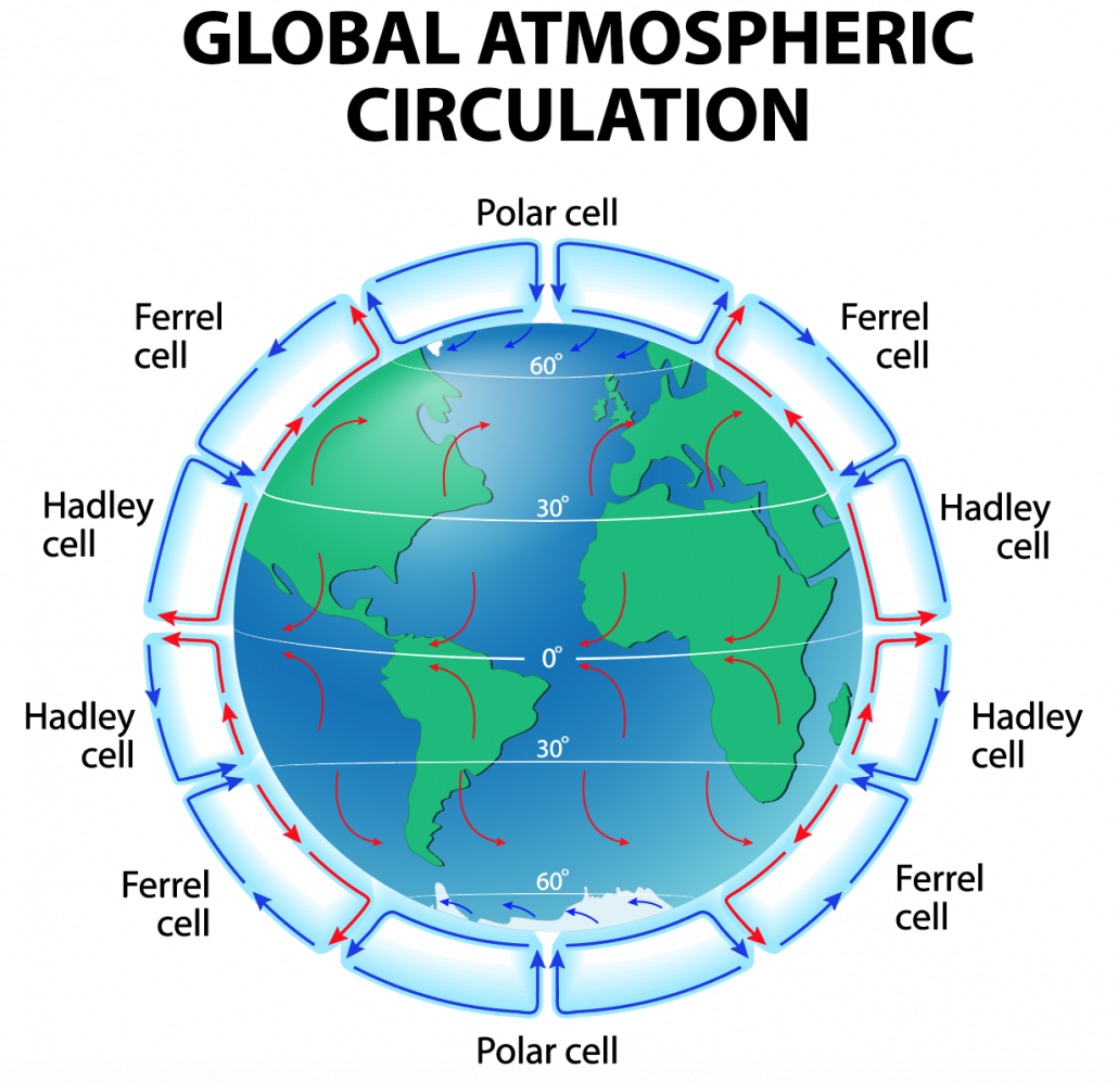
tropical storms
areas of extremely low pressure with high winds and rainfall.
split into 5 categories dependant on wind speed and damages (74-95, 96-110, 111-130, 131-155, 155+). categories are numbers with 1 being weakest
made up of bands of cloud - outermost bands being weakest, and the central band or eye wall is the most violent. strength is caused by pressure difference. these can be over 13km tall.
the eye in the centre is free of cloud and has no wind or rain, due to flow of dry air from the atmosphere. 16-48km large.
tropical storms - formation
formed over warm waters at a minimum of 27oC, and between 5-30o lat.
air is heated, and rises rapidly, drawing up more air and large volumes of moisture, causing strong winds.
the air is spun by the Coriolis effect, creating the eye of the storm.
air that has risen forms cumulonimbus clouds, causing the rain and giving off heat.
cool air sinks into the eye. it travels with the prevailing wind, and loses power as it travels over land.
climate change’s effect on tropical storms
increases distribution, as more oceans hit 27oC for longer periods, frequency, as storm season lengthens, and intensity, as higher temperatures supply storms with more energy, warmer air holds more moisture (4% rise in water vapour), and rising sea levels cause higher storm surges.
effects of tropical storms
people killed/injured by debris, building collapse, flash flooding and storm surges, destruction of buildings + infrastructure, loss and contamination of supplies (eg from sewers flooding)
people left homeless, waterborne disease outbreak, transport being blocked, businesses being forced to close, crops and livestock killed
responses to tropical storms
evacuating people from at-risk areas, rescue operations, providing emergency supplies and temporary shelters, recovering bodies, aid from governments and charities
repair and rebuilding work, rehousing, improving forecasting, warning systems and building codes, providing grant, business loans and tax breaks
typhoon Haiyan case study
cat 5 typhoon in the Philippines, near Tacloban, with wind speeds of up ton 195mph
buildings damaged and destroyed (90% of tacloban itself, 1.1 million houses and tonnes of crops), services lost (eg. electricity), flooding extending to 1km inland, killed 6190, injured 29 000, made 4 100 000 homeless and 14 100 000 were affected, costs of around $12 billion.
infection and disease spread due to contamination, fighting over supplies killed a further 8, power supplies were cut for months, education was disrupted, 800 000 litres of oil contaminated fishing water and 10 hectares of mangrove, looting was rife, rice prices increased by 12%, flooding caused landslides, airport was badly damaged
govt. issued televised warning to people to prepare and evacuate - 800 000 people evacuated, many of whom sought refuge in a stadium in Tacloban and were killed when it was flooded. govt. provided essentials and medical supplies, and a curfew was introduced to reduce looting. 1 200+ evacuation centres set up, airport reopened after 3 days allowing aid in, and over $1.5 billion aid pledged
cash for work programme paid for debris clearance and rebuilding efforts, and rebuilt buildings aim to provide better protection. mangroves have been replanted and a no-build zone has been set up.
planning for tropical storms - monitoring and prediction
tropical storms can be picked up on during formation, and pathing can be predicted. hurricane watches are issued if anything is picked up on. this is more of a HIC thing due to costs
planning for tropical storms - protection
building storm shelters - specialised buildings with windows covered with metal shutters, built off the ground on deep-pile concrete pillars to dissipate energy and are made from reinforced concrete.
sea walls on coasts reduce storm surges
planning for tropical storms - planning
stocking up on essentials, knowing where storm shelters are, evacuating i/a
weather hazards in the UK
the UK is prone to storms, which have been increasing in regularity and severity in recent years. periods of drought and heavy rain are both increasing in regularity. likewise, wind strength has been increasing, causing property damage etc
mean temperatures are increasing, especially in summers. all temperature records have been broken in the last 5 years, and are often rebroken year on year. this worsens aforementioned droughts
the 2022 heatwave caused UK temperatures to exceed 40oC for the first time in the century. this was worsened severely by climate change, and caused closures across the country as well as problems regarding heatstroke or water-related deaths trying to cool down (5 counts) etc. national warnings were issued, and gritters were deployed to prevent roads from melting.
evidence that UK weather is increasing in extremity
2022 was a record-warm year for the UK (exceeding 40oC from a past high below 39)
2022 received 6% below avg. rainfall, most of which occurred in February
sea level around the UK has risen by 11.4cm over the last 30 years
projections show this will continue to worsen unless drastic change is made
evidence of climate change
sea level rise of 1.9cm over the last century
ocean temperatures are the warmest recorded since 1850, glaciers are retreating
data gathered from ice and sediment cores support this. by analysing gases trapped in the ice, temperature estimates can be gathered, giving data up to 400 000 years into the past. similarly, tree rings and pollen analysis can give readings for slightly more recent and other more distant changes respectively.
temperature records provide reliable data for the short term.
causes of climate change
greenhouse gases in the atmosphere absorb and emit more of the infrared waves emitted by the earth from the sun. this keeps more of the heat in the atmosphere, increasing global temperatures.
as more greenhouse gases are released, this effect is magnified. this happens from burning fossil fuels, deforestation, agriculture, landfill waste decaying (releases methane) etc.
orbital changes (milankovitch cycles - earth’s tilt + orbit around the sun) magnify the effect, as do eruptions releasing more CO2 independent of human activity and solar output increasing the amount of heat released in the first place
management of climate change
mitigation involves reducing causes, and includes using green energy sources (expensive, can have other ecological impacts), carbon capture (also expensive), afforestation (takes land, expensive, if poorly managed the forests will still die) and international agreements (rarely followed).
adaptation includes changing agricultural practices (eg what crops are grown where), managing water supplies (increasing transport schemes), and coastal defences to reduce consequence of rising sea levels.