EARTHSC 2GG3 (Post-Midterm)
1/63
There's no tags or description
Looks like no tags are added yet.
Name | Mastery | Learn | Test | Matching | Spaced | Call with Kai |
|---|
No analytics yet
Send a link to your students to track their progress
64 Terms
What are the causes of slope failure?
Imbalance between friction and gravity forces as object moves downslope
Slope steepness (gravity overcomes friction)
Joints
cracks which are common in bedrock near earth’s surface
create planes of weakness
What causes joints to grow?
increasing slope angle
overburden removal
ice/root wedging
daily temperature changes
How are joints positioned in sedimentary rocks?
perpendicular to bedding
How are joints positioned in igneous rocks?
can be either perp or parallel to the surface
Exfoliation joint
onion skin-looking joint from erosion bringing igneous rocks to the surface
Planes of weakness
surfaces with less strength compared to material around it
e.g. wet clay/sand layers, joints, (Ex)foliation joints (foliation is metamorphic)
also influenced by slope orientation
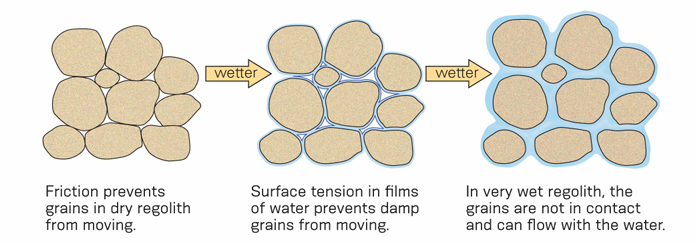
Cohesion
weak electrical charges attracting grains to each other
promoted by small amounts of water
overcome by too much water
Angle of repose
Steepest angle maintained to horizontal by cones of loose material on flat surfaces
30 - 37 deg for dry sand/gravel (higher when damp)
up to 45 deg for irregular gravel
Creep
slow, gradual downslope movement
common in temperate areas due to repeated expansion and contraction
Solifluction
creep in areas with permafrost
active layer slides downslope in overlapping sheets
methane and CO2 release
Slump
mass wasting where rocks/sediment stay mostly coherent during movement
Translational slump
slump where failure surface is planar
Rotational slump
slump where failure surface is concave
Head scarp
exposed, upslope edge of failure surface
Toe
downslope edge of slump rock
Mudflows & debris flows
Non-coherent flows of rock and sediment (higher water content)
can move up to 100 km/h
Mudflow
flow containing slurry of mud, and finer materials
Debris flow
flow containing mixture of mud and large rocks
Underwater slides
sediment dispersing, forming turbulent cloud under water
caused by earthquakes/large disturbances and hotspot volcanoes
Rockfalls
a mass free-falling down a cliff/steep slope (often vertical)
caused by joints/fracturs in rocks
Frost wedging
splitting of rock through pressure exerted when water freezes
dominant process causing rockfalls in cold regions
Rock slides & Strurzstroms
the largest and most destructive landslides
speeds up to 100-300 km/h
Rock slide
extremely rapid downslope movement of large volumes of rock and debris
Sturzstroms
aka rock avalanches
begin as rock slides then break up, taking on air and water
mechanism unclear
Fluidization
flowing as a fluid composed of rock fragments suspended in air
potential theory for Sturzstroms
Leda clay
aka quick clay
Water saturated mud deposited in salty water composed of clay flakes with large pore spaces between the flakes
highly unstable (glacial melting)
liquifies when disturbed
Weather disasters
Storms, hurricanes, and floods mainly driven by solar energy instead of energy from within the earth
main E source is the sun
Watch
issued when the drivers/signs of an event are present
high probability that event might happen
Warning
issued when we are sure the event will take place
Lapse rate
change of temp with altitude; ~6.5 °C/km
Troposphere
part of atm heated by IR radiation from earth's land and water
where we live
Stratosphere
part of atm heated by ozone absorbing UV light
temp increases with heigh
Mesosphere
part of atm that cools due to lack of ozone
temp decreases with height
Thermosphere
part of atm where high-energy radiation is absorbed by gases
What happens to air pressure and density with altitude?
They decrease with increasing altitude
Coriolis effect
shifting of wind movement path to the right due to earth's rotation
Speed of rotation decreases with latitude
Which direction do air masses curve in the N Hem?
they curve to the right
Which direction do air masses curve in the S Hem?
they curve to the left
Cyclone
air flows upward and counter-clockwise
Anticyclone
air flows downward and clockwise
Hadley cells
Air rises at 0°C and sinks at ~25° N and S lat
These cells are when tropical air warms, rises, and flows towards poles
Then subtropical air cools, sinks, and flows back towards equator
Control of rainfall in low latitudes
Trade winds
Trade winds: result as Hadley cell air flows toward equator
N hem surface winds curve southwest
S hem surfacer winds curve northwest
Intertropical Convergence Zone (ITCZ)
where N and S hems trade winds converge
N hem summer → shifts N of equator
S hem summer → shifts S of equator
Air pressure zones
More land mass is in N hem, more water in S hem
Southern hem has more buffering from water, resulting in less significant seasonal changes
Pressure in Northern winter
cold polar high pressure zones with cold air flowing off continents and rising in Icelandic and Aleutian lows
Pressure in Northern summer
highs pressure over ocean with onshore flow of moist air and monsoons
Front
When two different air masses meet with different temperature or moisture or both
Warmer air has potential to hold more moisture than cold air
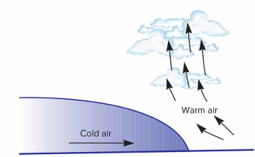
Cold front
cold air from north wedges under warmer air, forcing it upwards
Warm air cools down by force → thunderstorms and rain
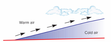
Warm front
warm air runs up and over colder air (more gradual since cold air is not 'moving') → cloud formation, rain not likely
How to make a single-cell thunderstorm
warm, humid air rises, forming clouds
rain/ice too heavy → condensation
warm updraft stops when enough has fallen
Supercell thunderstorm
same as a single cell storm but much larger and can rotate
Updraft and rotation combined lead to powerful tornadoes
Wall cloud
lower part of column, where updrafts are strongest
Anvil cloud
above the wall cloud, lots of lighting activity
How do tornadoes form?
Descend from wall cloud within supercell storm
Most tornadoes are formed within supercell storms
~30% of supercell storms produce tornadoes
Supercell formation -> watch
Funnel cloud descends -> warning
Tornado track
swath of destruction on the ground (focused destruction); path it takes across the ground
Enhanced Fujita Scale
Not based on wind speed (hard to track)
Classed based on worst damage caused by tornado