IB Geography Oceans and Coastal Margins.
1/92
There's no tags or description
Looks like no tags are added yet.
Name | Mastery | Learn | Test | Matching | Spaced | Call with Kai |
|---|
No analytics yet
Send a link to your students to track their progress
93 Terms
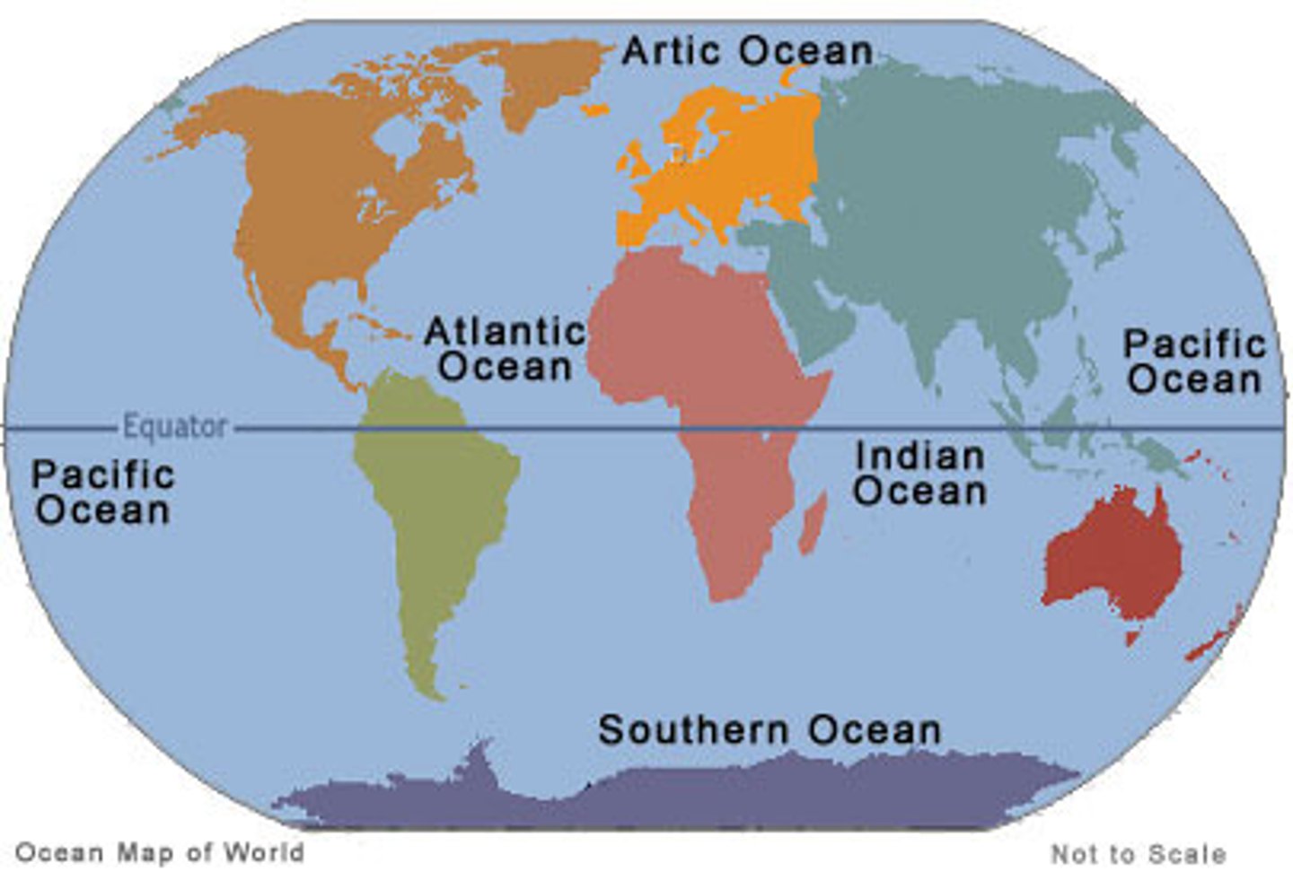
What are the 5 oceans of the world?
Pacific, Atlantic, Indian, Arctic, Southern
What are surface ocean currents caused by and what is the dominant pattern of the currents?
They are caused by the influence of prevailing winds blowing across the sea. The pattern of these currents is roughly circular in a clockwise direction in the northern hemispheres and anticlockwise in the southern hemisphere.
Why are ocean currents important?
Ocean currents affect marine life by bringing nutrients up from deeper waters and transferring energy. They affect temperatures by transporting heat, and affect rainfall by providing a source of moisture.
Upwelling currents
The movement of deep, cold, and nutrient-rich water from the ocean floor to the surface. They are found off the coast of Peru, California, and south west Africa. Occurs along the equator.
specific heat capacity
the amount of energy it takes to raise the temperature of a body. It takes longer for water to lose heat and it takes more energy to heat it up.
What are two main atmospheric states in the Pacific Ocean
1. Warm surface water in the west with cold surface water in the east
2. warm surface water in the east with cold surface water in the west.
Both cases allow for low pressure.
ocean conveyor belt
a constantly moving grand-scale system of deep-ocean circulation driven by temperature and salinity that transfers heat from the tropics to colder regions.
What are the patterns of the ocean conveyor belt?
Cold, salty water is dense and sinks to the bottom of the ocean while warm water is less dense and remains on the surface. The cold water from the Antarctic spreads into the deep basins of the Atlantic, Pacific, and Indian ocean. The surface currents bring warm water to north Atlantic from indian and pacific oceans. The north atlantic is warmer than north pacific and there is more evaporation in north atlantic.
What factors affect the density of seawater?
temperature, pressure, and salinity.
As temperature increases, water becomes less dense. As salinity increases, water becomes denser. As pressure increases, water becomes denser.
El Nino
A warming of the eastern pacific that occurs at intervals between 2-10 years and lasts up for 2 years.
Normal conditions of the Pacific ocean.
Near south america, winds blow the warm surface water offshore, causing upwelling of the cold, rich waters of the coast. The warm surface water is pushed into the western pacific, causing an area of low pressure and high rainfall. In South america, the sea surface temperatures are lower, high pressure exists, and conditions are dry.
El Nino conditions
Water temperatures in western pacific rise as warm water from the eastern pacific flows into the east. Low pressure develops over the eastern pacific, high pressure over the west. Heavy rainfall occurs over coastal south america whereas western pacific experiences warm, dry conditions.
El Nino effects on North America
Increases in pacific storm activity is matched with decreased Atlantic storm activity, so the east coast has less hurricanes. Farms in the midwest experience higher yields due to milder temperatures.
El Nino effects on West pacific
They typically experience droughts and dry conditions affecting coffee, oil palm, and hydroelectric production. They are more prone to forest fires. There are reductions in Indian soya bean harvest, wheat in Australia, and rice in China.
El Nino effect on Africa
It can bring disease due to heavy rains creating stagnat pools that allow mosquitoes to breed. Floods damage roads and make it difficult to distribute medicines, bed nets, and insecticides. It can cause water and food shortages, malnutrition, heatwaves.
La Nina
An intermittent cold current that flows from the east across the equatorial pacific ocean. It is an intensification of normal conditions whereby strong easterly winds push cold upwelling water off the coast of south america into the western pacific. Its impact is linked to unusual rainfall patterns in the Sahel and in India with unusual patterns in canada.
Cyclones, Hurricanes, Typhoons
A Cyclone is used in the South Pacific and Indian Ocean. Hurricanes are in the Atlantic and north east pacific. Typhoon is in the north west pacific.
Hurricanes
Low pressure systems that bring heavy rainfall, strong winds, and high waves, and cause other hazards such as flooding the areas they affects. Their origin is over moist tropical seas. Its path is erratic.
How do hurricanes develop
They develop as intense low-pressure systems over tropical oceans. The winds spiral rapidly around a calm central area-the eye. The strong contrast in pressure between the eye and the outer part lead to strong gale force winds. They move excess heat from low latitudes to higher latitudes. They begin as small scale tropical depressions, localized areas of low pressure that cause warm air to rise.
What are the conditions needed for hurricans to form?
1. Sea temperatures must be over 27 C to a depth of 60 metres (warm water gives off large quantities of heat when it is condensed and that drives it)
2. The low pressure area has to be far enough away from the equator so that the coriolis force creates rotation in the rising air mass. If it is too close there is insufficient rotation.
3. Conditions must be unstable.
What is the role of oceans as a source and store of carbon dioxide?
They are the largest CO2 sinks on earth and absorb more than 25% that humans release in the air. more than 90% has settled in the ocean. The biological processes turn CO2 into organic material that settles in the deep ocean. The Co2 dissolves from the atmosphere in surface waters, some staying as dissolved gas and others as organic matter. Carbon is also incorporated into marine organisms and when they die, their dead matter forms layers and over millions of years, get turned into rocks which lock the carbon into major reservoirs. CO2 is release in volcanic activity and by the burning of fossil fuels.
ocean acidification
decreasing pH of ocean waters due to absorption of excess atmospheric CO2 from the burning of fossil fuels. The pH has been lowered by 0.1. Causes include carbon emissions from industrial plants, power stations, cars, and plans. Species are threatened with extinction, fisheries face eradication, and coral reefs are starting to erode. The ocean is 30% more acidic than last century
What varies coastal landscapes?
Lithology properties, geological structure, processes, sea level changes, human impacts, and ecosystem types.
Waves
They are generated by wind blowing over the sea surface. They are controlled by wind strength and duration, fetch or distance of open water, and the depth of the sea bed.
constructive waves
A low wave that deposits material after it breaks, building up the beach. Swash is stronger than backwash. Long wavelength, low height, low frequency, low gradient, low energy. Low calm waves. They creates landforms
destructive waves
Found on steep beaches, are steeply breaking and mainly responsible for coastal erosion. Their backwash is much stronger than their swash. Harsh rugged waves. High height, high frequency, steep gradient, high energy.
swash
The movement of water up the beach after a wave breaks.
backwash
The backward movement of water down a beach when a wave has broken under the force of gravity
wave refraction
when waves approach an irregular coastline or are at an oblique angle. It reduces wave velocity and causes wave fronts to break parallel to the shore.
Longshore dift
This is when wave refraction is not complete. The swash carries material up the beach in a direction parallel to the prevailing wind. The backwash operates at right angles to the shore due to the steepness of the beach slope. The result is a net transfer of sediment along a beach that is not always straightforward. This allows the drift to approach the shore from an angle and carry sediment in zig-zag patterns.
tides
the regular rise and fall of ocean waters and movements in the sea surface cause by gravitational pull of the moon and sun.
littoral cell system
a simplified model that examines coastal processes and patterns in a given area.
types of weathering
salt weathering, freeze thaw weathering, water layer weathering, and biological weathering.
salt weathering
the process by which sodium and magnesuim compounds expand in joints and cracks, thereby weakening rock structures
freeze thaw weathering
the process whereby water freezes, expands and degrades jointed rocks
Water-layer weathering
the wetting and drying of some rocks from tidal fluctuations that breaks down the rocks physically. the physical, salt, and chemical weathering work together along edges of rock pools.
biological weathering
any weathering that's caused by the activities of living organisms.
Erosion
Processes by which rock, sand, and soil are broken down and carried away (i.e. weathering, glaciation). Loose materal is removed by waves
abrasion
The grinding away of rock by other rock particles carried in water, ice, or wind. The rock surfaces are scoured by wave induced flow with a mixture of water and sediment. It is the wearing away of the shoreline by material carried by the waves
Hydraulic action
The force of the water breaks rock particles away from the river channel. Wave induced pressure variations within the rock cause and widen rock cracks. The force of water and air on rocks
physical weathering
the mechanical breakdown of rocks and minerals. Frost action and cycles of wetting and drying cause and widen rock cracks
chemical weathering
The process that breaks down rock through chemical changes including hydrolysis, oxidation, hydration, and solution
biochemical erosion
chemical weathering by products of metabolism
biophysical erosion
physical removal of rock by grazing and boring animals
Formation of sea caves, archs, stacks, and stumps
Rapid erosion occurs on rocks where there is a weakness. Faults in the rock may be eroded to from sea caves. If two sea caves meet, an arch is formed. If the roof of the arch collapses, a stack is formd, an if this is eroded a stump formed.
wave-cut platform
the narrow flat area often found at the base of a sea cliff or along the shoreline of a lake, bay, or sea that was created by erosion. In its formation, steep cliffs are replaced by a lengthening platform and lower angle cliffs.
Spit
a beach of sand or shingle linked at one end to land. It is found on indented coastlines or at river mouths. They often become curved as waves undergo refraction. The main body can be curved and it could have additional smaller hooks, or recurves. They are often formed by longshore drift
Sand dunes
formed by a large supply of sand on the beach, high onshore wind speeds, low precipitation, and low humidity. There are two types: free and impeded. Free dunes dont have vegetation and are usually in deserts why impeded are in humid areas where vegetation is present.
Isostatic change
Local changes in sea level resulting from the land rising or falling relative to the sea.
ex: tetonic uplift of land after removal of ice sheet
eustatic change
A worldwide change in sea level, as distinct from local changes.
ex: global warming
Raised beaches
Areas of former wave-cut platforms and their beaches which are at a level higher than the present sea level
Defense against cliff failure and erosion
do nothing, maintain existing levels of defense, improve level of defense, and managed retreat.
Coral Reefs
contain nearly a million species of plants and animals, 25% of world's sea fish breed, grow, spawn, and evade predators in them. SOurces of biodiversity, seafood, new medicines, coastal protection. and economic profit.
ex: Great Barrier Reef
Mangrove Swamps
salt tolerant forests of trees and shrubs that grow in tidal estuaries and coastal zones of tropical areas. rich in nutrients and home to agreat biodiversity. Cover 25% of tropical coastlines. They provide ecological services, products, fish, protection from storms.
Exclusive Economic Zone (EEZ)
areas in whcih a coastal nation has soveriegn rights over all economic resources of the sea, seabed, and subsoil, extending 200 nautical miles from the coast.
Abiotic resources
resources that come from non-living, non-organic material
fisheries
Concentrations of particular aquatic species suitable for commercial harvesting in a given ocean area or inland body of water.
Aquaculture
Raising marine and freshwater fish in ponds and underwater cages commercial for food. They use drugs to keep fish healthy and to improve growth.
Oceanic pollution culprits
marine base activities like fishing industry, shipping, transport, tourism, fishing, offshore mining, extraction, illegal dumping, discarding fishing gear. Land based activites like discharge from stormwater drains, industrial outfalls, untreated municipal sewage, littering.
What are the three types of plate tectonic boundaries
divergent, convergent, and transform
divergent boundary
A plate boundary where two plates move away from each other. (constructive plate sites)
Convergent boundary
A plate boundary where two plates move toward each other.
Transform boundary
A plate boundary where two plates move past each other in opposite directions
What are three types of plate sites?
constructive, destructive and conservative
constructive plate sites
sites where the earth crust is formed. The plates move away from one another(divergent boundary) as upwelling of molten material occurs at the mid ocean ridge. The molten material is what forms the earth crust at the site.
destructive plate sites
sites where earth crust is destroyed. Oceanic crust is abducted beneath the continental crust. The previously crust is crust moves under another site and breaches the first layer of the earth
conservative plate sites
sites where earth is neither created or destroyed but they are sites associated with frequent and high magnitude earthquake activity.
(transform boundaries)
Volcanic Islands
When two oceanic plates collide where one oceanic plates sinks beneath the other. It will partially melt and generate molten material.
When the molten material reaches the ocean floor it will form pillow lava that will overtime build up the form underwater volcanoes and eventually volcanic islands or island arcs. (destructive sites)
Ocean Trenches
deep sections of the ocean, usually where an oceanic plate is sinking below a continental plate. They are at points of ocean crust subduction.
ex: mariana trench, tonga trench
Mariana Trench
The location of the deepest trench on earth made from two oceanic crusts converging. also known as challenger deep
tonga trench
2nd largest oceanic trench in the world. Formed by convergent boundaries, specifically oceanic-oceanic. also known as horizon deep
Ekman transport
refers to winds moving surface water away from the coastline
downwelling
The movement of water from the surface to greater depths.
Storm surges
an abnormal rise of water generated by a storm, over and above the predicted astronomical tides; the rise in seawater level caused solely by a storm.
tsunamis
a seismic sea wave, is a series of waves in a water body caused by the displacement of a large volume of water, generally in an ocean or a large lake
Tornadoes
A violently rotating column of air stretching from a cloud to the ground. Form over land due to cold air coming into contact with warmer air off land. Usually small scale, short lived, hard to predict and track.
point bars
a crescent-shaped accumulation of sand and gravel deposited on the inside of a meander.
Ridge and Runnel
The "ridge" of a ridge and runnel system is a sandbar. The "runnel" is the trough-like area between the ridge and the beach.
berms
relatively flat platforms often composed of sand that are adjacent to coastal dunes or cliffs and marked by a change in slope at the seaward edge
lagoons
a stretch of salt water separated from the sea by a low sandbank or coral reef.
reefs
a ridge of rocks or sand, often of coral debris, at or near the surface of the water.
geopolitics
interplay among geography, power, politics, and international relations
What are the types of pollution?
nutrient loading, oil spills, industrial waste, rubbish dumping.
nutrient loading
Too many nutrients, mainly nitrogen and phosphorous are added to bodies of water and can act like fertilizer, causing excessive growth of algae. Nutrients can run off of land in urban areas where lawn fertilizers are used
oil spills
The release of liquid petroleum into the environment, especially the marine ecosystem due to human activity.Human activity is usually drilling. It's not the drilling that causes the problem, it is with the faulty equipment. If pipelings become faulty and has cracks, it is a problem.
industrial waste
industrial material that is rendered useless such as chemical solvents, pigments, sludge, metals, ash, paints, sandpaper, paper products, radioactive material
Rubbish Dumping
disposing of unwanted materials
fault zone
A crack in the Earth's crust where rocks slide past one another. Different types may form based on direction of plate movement.
abiotic components
Nonliving chemical and physical factors in the environment.
ex:water flow rate, salinity, acidity, oxygen, light levels, depth, and temperature
biotic components
living organisms/components of ecosystem
ex: algae, fungi, microorganisms (such as bacteria), plants, animals and corals.
coral bleaching
A phenomenon in which algae inside corals die, causing the corals to turn white. Warmer water temperatures can result in coral bleaching. When water is too warm, corals will expel the algae (zooxanthellae) living in their tissues causing the coral to turn completely white. Above-average sea water temperatures caused by global warming is the leading cause
Soft engineering
Managing erosion by working with natural processes to help restore beaches and coastal ecosystems
Hard engineering
Building artificial structures such as sea walls aimed at controlling natural processes