THE MAIN MODELS
1/27
There's no tags or description
Looks like no tags are added yet.
Name | Mastery | Learn | Test | Matching | Spaced | Call with Kai |
|---|
No analytics yet
Send a link to your students to track their progress
28 Terms
Demographic Transition Model (DTM)
A model showing how a country's population changes as it develops from an agricultural to an industrial society, tracking birth and death rates through five stages.
Purpose of the Demographic Transition Model
To help geographers and governments forecast population growth and understand the social shifts that accompany industrialization.
Limitation of the Demographic Transition Model
It is based on Western Europe's history and assumes all countries will industrialize in the same way.
Von Thünen Model of Agricultural Land Use
Predictions about the occurrence of different types of farming around a central city based on transportation costs and perishability.
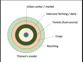
Reason for the Von Thünen Model's existence
To explain how land value and the cost of transporting goods to market influence farmers' decisions.
Limitation of the Von Thünen Model
It assumes the land is perfectly flat with no rivers or mountains and there is only one central market.

Burgess Concentric Zone Model
Suggests that a city grows outward from a Central Business District (CBD) in rings, with different social groups living in each ring.

Purpose of the Burgess Concentric Zone Model
To explain urban growth patterns, specifically in Chicago during the 1920s, based on competition for land.
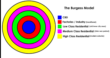
Limitation of the Burgess Concentric Zone Model
It does not take into account modern transportation systems, allowing for more dispersed living patterns.
Rostow’s Stages of Development
A linear, five-stage path for a country to evolve from a traditional agricultural society to 'High Mass Consumption'.
Why Rostow’s Stages of Development exists
Designed as a guide for poor countries to modernize by mimicking Western capitalism.
Limitation of Rostow’s Stages of Development
It overlooks external factors like colonialism and assumes every country has the same resources and geography for success.
Wallerstein’s World System Theory
Views the global economy as a single system divided into Core (wealthy), Periphery (poor), and Semi-Periphery (middle) countries.
Purpose of Wallerstein’s World System Theory
To explain the persistence of global inequality, where Core countries exploit Periphery countries for cheap labor and resources.
Limitation of Wallerstein’s World System Theory
It can be too general, ignoring internal factors like culture or local politics.
Real-World Example of DTM Stage 5
Japan is currently in Stage 5 where birth rates are so low that its population is shrinking.
Real-World Example of Von Thünen Model
Large dairy farms are often located closer to urban centers like the Northeastern U.S. because milk is perishable.
Real-World Example of Burgess Model
Older American cities like Chicago exhibit characteristics of the Concentric Zone Model despite modern modifications.
Real-World Example of Rostow's Model
Singapore is frequently cited as a country that has successfully progressed through Rostow's stages to reach high mass consumption.
Real-World Example of Wallerstein's Theory
The United States is a Core country that imports raw materials from Periphery countries, such as the Democratic Republic of Congo.
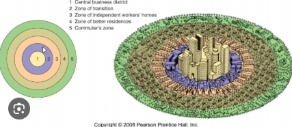
burgess concentric zone model
a model that describes urban land use in concentric rings, with the city center at its core.
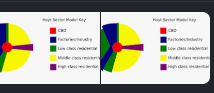
Hoyt Sector Model
A model that describes urban land use in sectors or wedges stemming from the Central Business District (CBD), reflecting how certain types of industries and housing are located along transportation routes.
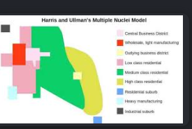
Harris-Ullman Multiple Nuclei Model
A model of urban land use that suggests cities have multiple centers (nuclei) of development, each with distinct characteristics, rather than a single central point.
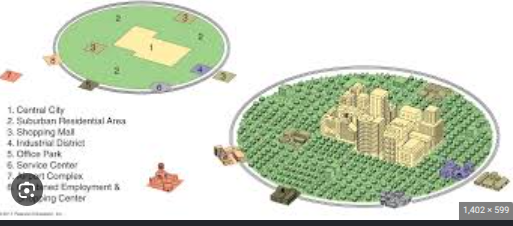
Galactic City Peripheral Model
A model that illustrates a city structure characterized by a central city surrounded by suburban areas, which are connected by a network of highways and characterized by low-density development.
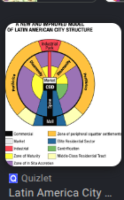
Latin American City Model
A model that describes the layout of many Latin American cities, featuring a central Plaza, a commercial spine bordered by high-quality housing, and a zone of in situ accretion with poorer housing on the periphery.
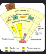
Southeast Asian City Model
A model that reflects the urban structure of Southeast Asian cities, with a mixture of colonial port zone, high-rise commercial areas, and informal settlements, highlighting the influence of trade and colonial history.
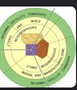
African City Model
A model that depicts the urban structure of African cities, often featuring a central business district, a zone of transition with informal settlements, and separated residential areas that reflect historical and social factors.