coptr stage 2 - edited
1/259
There's no tags or description
Looks like no tags are added yet.
Name | Mastery | Learn | Test | Matching | Spaced | Call with Kai |
|---|
No analytics yet
Send a link to your students to track their progress
260 Terms
ceiling definition
lowest broken, overcastg, or obscured (BKN/OVC/VV) layer of clouds
flight vs ground vs prevailing visibility
flight visibility = forward horizontal distance a pilot can see
ground visibility = prevailing horizontal distance near earth's surface
prevailing visibility = measurement of greatest distance visible thru at least half of horizon (in SM or RVR)
Class A VFR fly-through weather minimums
N/A (IFR only)
Class B VFR fly-through weather minimums
3-COC
3 SM visibility
clear of clouds
Class C, D, E<10,000 MSL, Night G between 1200 AGL and 10,000 MSL
VFR fly-through weather minimums
3-1-2-5
3 SM visibility
clouds clear: 1000' above, 2000' lateral, 500' below
What airspaces have:
3-1-2-5
3 SM visibility
clouds clear: 1000' above, 2000' lateral, 500' below
C
D
E<10,000 MSL
Night G between 1200 AGL and 10,000 MSL
Class E>10,000’ MSL & G>10,000’ MSL
5-1-1SM-1
5 SM vis
1000' above + below, 1 SM lateral
Day Class G 1200' AGL-10000'MSL weather minimums
1-1-2-5
1 SM
1000' above, 2000' lateral, 500' below
Class G < 1200’ AGL
DAY - ½ SM, clear of clouds
NIGHT - 1SM, clear of clouds
special VFR
ATC clearance required in airspace when weather is < VFR minimum
grants 1 SM and clear of clouds
Mode C Requirements
Class A,B,C
Above Class B+C within lateral limits
Within 30 NM of Class B
ADIZ
Above 10,000'MSL
Class A dimensions
18000' MSL - FL600
Class B dimensions
surface - 10000'MSL
*individually tailored upside down wedding cake
Class C dimensions
inner 5NM radius: SFC - 4,000' AGL
outer 10NM radius: 1200 - 4,000' AGL
Class D dimensions
SFC - 2500' AGL
individually tailored; typically, 4-5 NM radius
Class E dimensions
can either start at:
surface
700' AGL
1200' AGL
as depicted on zipper
goes up to 17999' MSL
above FL600
VFR T/O, LDG, TP requirements for B, C, D, E
1000’ ceiling and 3 SM ground vis
Class G dimensions
can go up to 14,500'MSL
typically surface to 700 or 1200' AGL
requirements to enter Class A
2 way radio
Mode C transponder
IFR rating and aircraft
ATC clearance
ADSB Out
requirements to enter Class B
2 way radio
Mode C transponder
VOR (IFR)
Private Cert or Student Pilot Endorsement
"Cleared to enter Class B, tail #" from ATC
ADSB Out
requirements to enter Class C
2 way radio
Mode C transponder
ATC clearance stating tail #
ADSB Out
requirements to enter Class D
2 way radio
ATC clearance stating tail #
requirements to enter Class E
none other than:
ADSB Out when >10000'MSL (excluding <2500' AGL)
requirements to enter Class G
none
chart depiction Class A + def
none
A/s that spans across the entire United States and its coastal waters (up to 12 nautical miles off the coast).
chart depiction Class B + def
solid blue line
A/s surrounding the nation’s busiest airports in terms of IFR ops or passenger enplanements
chart depiction Class C + def
solid magenta line
A/s surrounding airports w/ operational control tower & certain # of IFR/passenger enplanements (less busy than class B airports)
chart depiction Class D + def
dashed blue line
Airspace from SFC to 2500’ AGL w/ operational control towers
chart depiction Class E + def
depiction
from surface: dashed magenta
from 700' AGL: shaded magenta
from 1200' AGL: shaded blue or nothing
Def
controlled A/sp that is not A, B, C, D
chart depiction Class G + def
none
uncontrolled airspace that has not been designated class A, B, C, D, or E
using agency vs controlling agency
using agency - org/military/person that warrants the reason for special airspace
controlling agency - FAA agency that authorizes flight thru special airspace
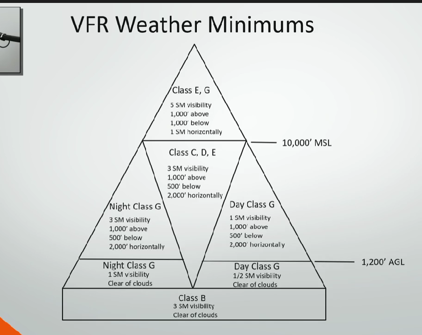
Draw the VFR wx mins triangle
prohibited area
blue comb
flight is PROHIBITED for security or sensitive reason
restricted area
blue comb
has active/inactive status of often invisible hazards. must get permission from using or controlling agency to enter.
warning area
blue comb
3 NM off US coastline
military ops area
magenta comb
separates IFR and military traffic
VFR should contact within 100NM
alert area
magenta comb
high volume of pilot training or other activity
controlled firing area
area where munitions are tested and pose hazard to nonparticipating aircraft
not depicted on sectionals
national security area
dashed magenta line
increased security area; pilots must avoid
special use airspace types (WARM PNC)
warning area
alert area
restricted area
military ops area
prohibited area
national security area
controlled firing area
other use airspace types (SWAMPPTT)
AIM 3-5-1
special air traffic rules area (SATR)
weather reconnaissance area
airport advisory area
military training route
parachute jump areas
published VFR routes
terminal radar service area
temporary flight restriction
airport advisory area
-other use area extending 10SM from airports with FSS but no operating control tower; in alaska "LAA"
-RAIS = remote airport information service from FSS for temporary events, published in NOTAM D
military training route
-other use area for military low level combat training
-usually below 10000'MSL and >250kts
-VR for VFR, IR for IFR, 4 label has no segment >1500'AGL, 3 label has segment >1500'AGL
temporary flight restriction
-other use area where FAA prohibits flight temporarily
parachute jump areas
-other use area where parachute operations are
-when in area, listen to tower/CTAF and scan constantly
published vfr routes
-routes for transiting through/under/around class B or complex airspace
-3 types: VFR flyways, VFR corridors, transition routes
vfr flyways
-published vfr route that doesn't require clearance
-depicted on reverse side of TAC usually with blue line
transition routes
published vfr route that requires clearance, has specific alt and headings labeled on TAC
vfr corridor
-published vfr route that's basically a tunnel of Echo through Bravo
-doesn't require clearance
-has CTAF frequency
terminal radar service area
-other use airspace where pilots can voluntarily participate to get additional radar services
-basically Delta airport with Charlie services separating IFR, VFR
-depicted with solid gray line
special air traffic rules area
other use airspace with extra rules from 14 CFR Part 93
weather reconnaissance area
-other use airspace for weather research published by NOTAM
-only research aircraft allowed
-no ATC services
ADIZ
air defense identification zone
area of airspace over land or water requiring ID, location, and control of aircraft for security interests
must have transponder, 2 way radio, and flight plan
what is required to enter ADIZ
transponder, 2 way radio, and flight plan (DVFR or IFR)
wildiife area min altitude
2000' AGL
landing prohibited unless emergency or special permission
all weather is the result of ?
uneven heating/cooling of the earth's surface
composition of the atmosphere
78% N2, 21% O2, 1% argon, CO2, water vapor between 0-5%
layers of the atmosphere
troposphere
tropopause
stratosphere
mesosphere
thermosphere
troposphere dimensions
over poles: sea level to 20000'
over equator: sea level to 48000'
which layer of the atmosphere contains most weather, clouds, temp changes?
troposphere
standard lapse rates in troposphere
-2*C per 1000'
-1"Hg per 1000'
where is the jet stream and clear air turbulence often located
tropopause
tropopause
-boundary of troposphere, trapping moisture and weather inside
-abrupt temp change
-altitude varies with latitude and season
stratosphere dimensions + weather
-from tropopause to ~160000'
-barely weather and turbulence, may have ice clouds
-temp increases with height
convection
-cycle of cold denser air sinking and warm air rising, cooling, and then sinking back down
-results from uneven heating of air by contrasting surface temps
pressure gradients
-force created by pressure differences driving wind
-flows high to low
-closer pressure/isobars = stronger gradient; farther pressure/isobars = weaker gradient
isobars
lines of constant pressure
how does wind behave from Coriolis and pressure gradient forces?
the rotation of Earth creates Coriolis, deflecting air to right in N hemisphere and to the left in S hemisphere
pressure gradient flows perpendicular to isobars and balances Coriolis, which deflects wind 90*
how does friction change the wind, Coriolis force, and pressure gradient?
friction weakens Coriolis force, slows and deflects wind ~15-30*, and has no effect on pressure gradient force
what are the 3 wind cell circulation patterns created by Coriolis?
Hadley - rises at equator, flows away, sinks at Ferrel border, and back to equator
Ferrel - sinks at Hadley border, flows towards poles, rises at Polar border, flows back towards Hadley
Polar - sinks at pole, flows away, rises at Ferrel border, flows back
high pressure air flow and characteristics
flows CW and down
generally dry, stable
low pressure air flow and characteristics
flows CCW and up
generally unstable, bringing clouds/rain
cause of convective currents
caused by heat radiating off different surface types (updrafts over pavement/barren and downdrafts over water/vegetation)
where are convective currents commonly experienced
when flying lower altitudes during warmer weather
(avoid by flying higher altitudes)
sea breeze
during day, land is warmer than sea, so colder air over water sinks and flows inland to replace the warmer air rising
land breeze
during night, land is cooler than sea, so cold air over land sinks and flows out to sea to replace the warmer air rising
valley breeze
during day, mountain slopes are warmer and the air rises cools, and sinks in the valley before circling back up the slope to replace the warmer air
mountain breeze
during night, mountain slopes are cooler and the air sinks until it hits the inner warmer valley and rises back up
water vapor vs relative humidity
water vapor = amount of moisture in the air
relative humidity = % of water vapor in the air compared to the max amount of water vapor it can hold
what is the air called when it is 100% relative humidity
saturated
how does temperature affect capacity of relative humidity?
higher temps = higher capacity
lower temps = lower capacity
(so the air can hold more water the warmer it is)
dew point
the temp at which the air must be cooled to become 100% saturated by the water vapor present in the air (when condensation begins)
temp dew point spread
difference between temp and dew point
(lower spread = higher humidity)
latent heat
the energy absorbed or released during a change in state
adiabatic
no heat removed or added to air during temp change
adiabatic heating
process of heating air by compression
adiabatic cooling
process of cooling air thru expansion
lapse rate for saturated vs unsaturated air
saturated air has slower lapse rate (1.1-2.8C / 1000') than unsaturated air (3C / 1000')
condensation occurs when _______
saturated air moves upward
3 requirements for clouds to form
water
lifting action/cooling mechanism
condensation nuclei
how do clouds form?
air rises, expands, cools adiabatically in upward motion
reaches dew point and becomes saturated = water vapor becomes visible
atmosphere stability definition
air’s ability to resist vertical motion
cool, dry air is ____ stable and ____ veritical movement. Warm moist air is very ____.
very
resists
unstable
how do inversions affect atmospheric stability and how does it occur?
inversion = when temp increases with altitude
it acts like a lid holding in weather + pollutants
this can decrease visibility
this can also limit vertical development of clouds = more stable atmosphere
this can happen at surface if the ground cools the air from below
stable atmosphere characteristics
flight: smooth
surface vis: poor
smoke/haze trapped
clouds: stratiform (sheet-like)
precipitation: steady
temperature inversions = stable air
air closer to ground is cooler than higher air
unstable atmosphere
flight: turbulent
surface vis: excellent
clouds: cumuliform (heaping)
precipitation: showery / thunderstorms possible
regular temp lapse rate
air closer to ground is warmer than higher air
nimbus =
rain
cumulus =
heaped
stratus =
sheet like / layer
alto =
middle