WSC 2026 (last 5)
1/93
There's no tags or description
Looks like no tags are added yet.
Name | Mastery | Learn | Test | Matching | Spaced | Call with Kai | Chat |
|---|
No analytics yet
Send a link to your students to track their progress
94 Terms
Magnetic compass
A direction finding tool that uses a magnetic tool that was invented in China (there is a discrepancy between Magnetic North and True North)
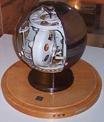
Gyrocompass
A compass that uses Earth’s rotation to point true north (avoids discrepancy)
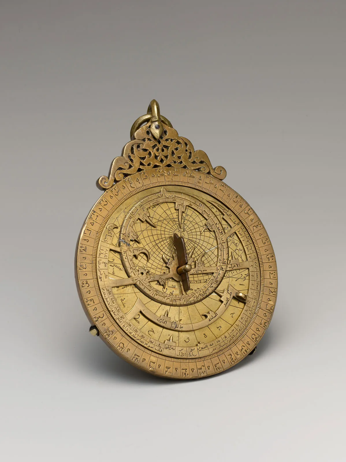
Astrolabe
An astornomical instrument used to measure the altitude of the sun or stars and to determine time and lattitude
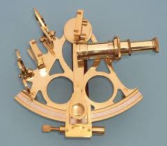
Sextatnt
A device that measures angular distance between 2 visible objects, was found in unpublished writings of Issac Newton (developed version of the astolabe)
Log Tables
対数表、helped with calculations and to find the position of celestial bodies
Ephemerides
Book with tables that give the trajectory of stars
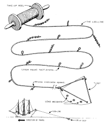
Log and line
used for determining a ship’s speed
Chronometer
A precise time keeping tool for maritime navigation, invented by Jeremy Thacker
Magnetoreception
ability of oranisms to sense the earth’s magnetic field
Cryptochrome
blue light-sensitive proteins found in animals that are involved in the sensing of magnetic fields
Olfactory navigation
navigating using smell (used by passenger pigeons)
Echolocation
Animals using SONAR to navigate (duh)
Zugunruhe
anxious behavior in migratory animals when they are kept enclosed during migratory periods
Constant frequency
a wave with a constant frequency
sunlight polarization
the way sunlight becomes partially aligned in a specific direction after interacting with Earth’s atmosphere
spatial memory
brain stores and retrieves info regarding navigation and the physical spaces around an individual
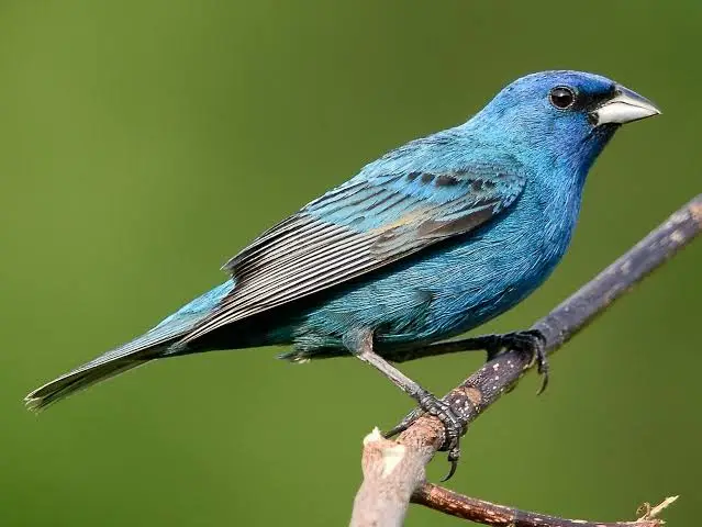
Indigo Buntings (特徴)
migrates to central america from USA during winter, navigate using the North Pole Stars
Dung Beetles (特徴)
Rolls dung to attract femal mates, must be fast, must roll in a straight line, uses the milky way to follow a straight path because it is very visible in South Africa
Honeybees (特徴)
Follow linear landmarks to find their hive, use Olfactory navigation and changes in polarization of light
Sea turtles (特徴)
use variations in Eath’s magnetic field to navigate to nesting areas (each geo area has a distinctive magnetic pattern!)
Dessert Ants (特徴)
uses a step counter, sky compasses, olfactory and other methods to navigate

Nainoa Thompson
A native hawaiian navigator who revived traditional Polynesian methods of navigation
Inuit Navigation
Navigation styles using the night sky and other markers to find their way, even in a landscape white with snow and ice
Viking navigation
navigation system using a “sunstone” that showed the position of the sun even on cloudy days through the polorization of light
Fog of the World
An app that tracks your exploration, uncovering areas from clouds as you explore them
The Terminal (Film)
-Depicts a person who travelled to the US only to find that his country had collapsed, making his passport invalid
-He can’t go back nor enter the US
-He starts living in the terminal
Mehran Karimi Nasser
The model of The Terminal, an Iranian refugee that resided in Paris’s Charles de Gaulle Airport
Edward Snowden
A former national security agent who spent 6 weeks hiding in Moscow’s Sheremetyevo airport after leaking documents showing the existence of global surveillance programs
St. Louis
a ship carrying Jewish refugees from Nazi Germany to escape the holocaust
Macadam
a road constructed with crushed stones placed in layers then covered with cement and tar
Pavement
the surace of a road covered with conctrete or tarmac
Asphalt (Bitumen)
Materials used to make the surface of roads
Corduroy Road (Log Road)
Made by placing logs perpendicular to the direction of the road, used in swampy or muddy areas
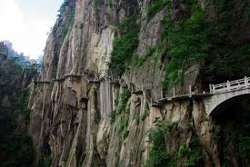
Gallery Road (Cliff Roads or Plank Roads)
Often used in China, made up of wooden planks fastened into cliff sides
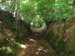
Holloway Roads (Sunken Lane)
A road that is significantly lower than the land on either side
ridgeway
a road using hard surace of hilltops as unpaved roads
mile stones
markers that show distance from/to a town or city
Trackway
a path formed by people walking over an area repeatedly
Solar Roadways
Roads using solar panels instead of asphalt
Piezoelectric materials
Materials that generate an electric charge from a mechanical force (japan is turning footsteps into electricity kinda stuff)
Inductive Charging
Wireless charging
DSRC (Dedicated short-range communications)
A wireless communication technology designed for vehicles, allows cars and roadside units to exchange data quicly over a short distance (such as ETC)
Self-healing asphalt
Repairs cracks automatically
Modular pavement
Consists of small modules similar to bricks or tiles
Makes repair easier and faster
Permeable pavement
made of porous materials allowing water drainage, prevents cracks from forming due to water pooling
Traveling salesman problem
A problem where you must find the shortest possible route that visits each location exactly once and returns to the starting point
Vector-based navigation
a method of guiding movement using direction and distance, rather than fixed paths or step‑by‑step instructions. It uses continuous updates of movement.
Explore-Exploit Problem
A decision-making dilemma where you must choose between new and known options
Desire paths
the physical evidence of shortest distance between two points
Route elasticity
Describes how sensitive travel demand is to changes in a specific route’s characteristics
Braess’s Paradox
a situation where adding a new road makes overall traffic worse (individuals overload the new link and create a worse equilibrium for everyone)
dead reckoning
a navigation method where you estimate your current position based on a previously know position, plus your speed, direction, and time traveled.
the Steiner Tree Problem
Minimising network connection length
stroad
a dangerous, inefficent hybrid of a street and a road
Route 66 (THe mother road, America’s Main Street)
A historic US highway that runs through eight states, from Illinois to California. It became a major route for people migrating west during the Great Depression
Heritage Tourism
travel focused on visiting historical site
Ecotourism
Enviromentally responsible travel
Gastrotourism
Traveling to enjoy the destination’s cultural food
Agritourism
Farm-based tourism
Monastic Retreats
Spiritual Isolation Periods
voluntourism
volunteering while travelling
edutourism
a form of tourism that combines travel with learning
wellness retreats
a getaway intended to improve well-being
dark tourism
visiting of sites associated with death
entrepots
a trading center where goods are imported, stored, and then re-exported
Waystations
a stopping point used during a journey
Free-trade zones
areas with reduced trade barriers
transshipment
the shipment of goods to an intermediate destination, then to another destination
caravanserai
roadside inn for traders
silk road
ancient eurasian trade network
Piraeus / Tyre / Lothal / Carthage / Malacca / Istanbul / Chicago / Hong Kong
major historical or modern trade hubs
Shimoda, Hakodate
Japanese treaty ports
fusion power
Energy from atomic production
Nishiyama Onsen Kiunkan
world’s oldest hotel and oldest operating buisness
The Grand Tour
an expensive tour around Europe for English aristocrats
The Golden Age of Travel Starts with You
Campain by the US dept. Of Transportation to restore courtesy and class to air travel, started from 2025
Xiaohongsh
Chinese equivalent of Instagram known for promoting niche tourist sites
graphene
ultra-strong carbon material
nanotechnology
the understanding and control of matter at the nanoscale
artifical general intelligence
human level ai
organoids
minature lab-grown organs
bioprinting
the use of 3D printing tech to produce tissues
plasma transfusion
a medical treatment where the liquid part of blood (plasma) is take from a healthy donor and given to a patient
senotherapeutics
Treatments that target and manage senescent cells that accumulate with age and cause tissue disfunction
cellular reprogramming
the resetting of the age of a cell
cellular rejuvenation
the process of repairing age-related damage within cells to restore them to a youthful, functional state
telomere extension
the process of lengthening telemores so cells can stay healthy and divide longer
caloric restriction
reducing daily calorie intake to extend lifespan
digital immortality
the concept of perserving a person’s consciousness in a digital format like AI
cryonics
the freezing of dead bodies aimed at reviving them when furture technology allows
Wardenclyffe Tower
a tower that Tesla was trying create which allows global, wireless communication
the sunk cost fallacy
our tendancy to follow through with something that we’ve already invested heavily in, even when giving up is clearly a better idea
the dichotomy paradox
a paradox which states that in order to reach a destination, one must travel half the distance, then half of the remaining, and so on—but then they’ll never get there.