L5 Orography and mountain climates
1/21
There's no tags or description
Looks like no tags are added yet.
Name | Mastery | Learn | Test | Matching | Spaced | Call with Kai |
|---|
No analytics yet
Send a link to your students to track their progress
22 Terms
Why is mountain topography important for climate and weather patterns?
Mountain topography can influence precipitation patterns; and
Changes in precipitation can have significant consequences for mountain environments.
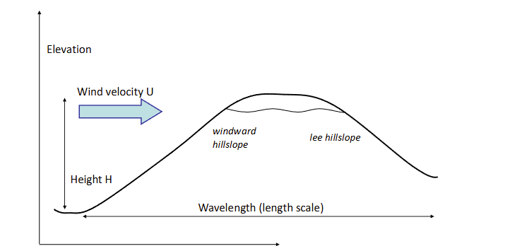
Diagram shows a simple mountain landscape as it may relate to climate.
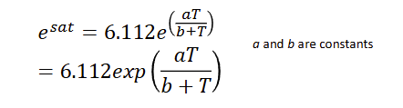
When does air become saturated and what does the fulfilment of this depend on?
Air becomes saturated when the partial pressure of atmospheric water vapour reaches a threshold value (e sat); and
The satisfaction of this threshold depends primaryily on temperature/
This is shown in the equation linked.
What happens to the saturation of air if temperature is lower, and how does this link to mountain topography?
Lower temperature → saturation of air decreases and precipitation is condensed.
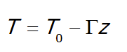
Temperature decreases linearly with height in the lower atmosphere, meaning e sat can be converted to a function of elevation (z).
T0 is the temperature at the surface, the squashes T is the lapse rate, or rate at which temperature typically decreases (usually approx 6 degrees per km).
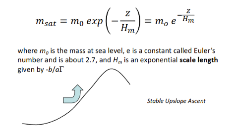
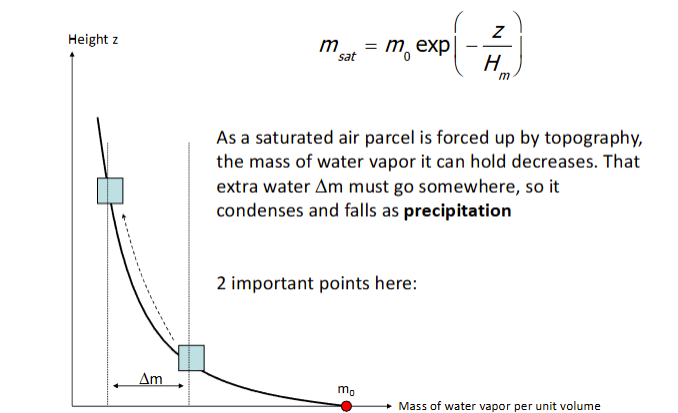
What happens if air is forced upwards by topography?
It cools and expands, and e sat decreases. This means that air can become saturated more easily, and the mass of water vapour per unit volume of air (m sat) becomes (diagram equation).
How are exponentials usually represented?
There is a constant on the y axis normally (y0 = value of x at 0);
x* sets how quickly the curve falls off as x increases - sometimes called a scale length; and
Intercept and slope are specified to describe an exponential function.
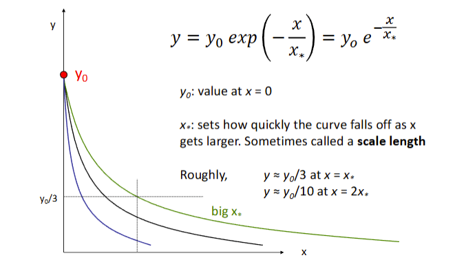
Why are exponentials useful in atmospheric context?
They can tell us how much water is in the atmosphere as height/elevation progresses, and therefore the maximum water available for precipitation?
How is precipitation created by mountain topography?
As described (and shown) in the image, saturated air is forced upwards by topography. As it is forced upwards, the mass of water vapor it can hold decreases. That extra water (delta m) condenses and falls as precipitation.
What are the two important points with this process of precipitation condensation due to elevation?
Precipitation maximum occurs in different places depending on the size of the mountain range - small ranges have a fairly even precipitation pattern as there is still lots of available moisture to be extracted at the crest. Large ranges have maximums occuring at lower elevations on windward slopes as air at the crest has already lost most of its moisture. Height of topography relative to scale length determines precipitation patterns (stable upslope ascent); and
The rate of condensation (C) depends on how quickly m sat decreases with height, and how rapidly air parcels are moving upwards.
What are the three summary points for part A?
As air is forced upwards, its ability to carry water vapour decreases, so vapour condenses and rains out;
The capacity of air to carry water decreases exponentially with height (and most of the decline happens in the first few km); and
Larger ranges (> 2 - 4km) should have maximum rainfall on the windward side whereas small ranges should have even more distribution.
What is the most common method of measuring precipitation?
Rain gauges - cheap and can be used continuously for long periods of time to log data (useful on decadal time scales). However, they are flawed in that they only measure rainfall at very specific locations; large densities of rain gauges are needed to cover entire mountain ranges.
What is an alternative measurement method to rain gauges?
Satellite imaging. The Tropicl Rainfall Measuring Mission (TRMM) used reflectivity of a radar beam by precipitation particles in the atmosphere. This is converted to a vertical precipitation rate profile for each ‘pixel’ in the image. This network has since been replaced by a collection of satellites called the GPM. Satellite imaging to monitor precipitation is useful as it can also show relationship to topography.
How can precipitation patterns develop across major mountain ranges?
Himalayas - large river valleys form pathways which allow moisture to penetrate further into the range.
Olympic mountains - precipitation totals are two times higher on ridges than in adjacent valleys. Ridges intercept westerly airflow and drive it rapidly upwards.
What are the main mechanisms driving orogprahic precipitation?
Stable uplslope ascent;
Unstable upslope ascent leading to convective storms;
Diurnal heating and convection;
Low mountains enhancing precipitation on the lee side;
Waves and wake effects;
Blocking of air masses by stagnant air on the windward side;
Buildup of heat under a ‘lee side cap’ - lead to powerful convection when the cap is broken.
How can the projection trajectories be measured?
Trajectory of precipitation can be estimated using the terminal velocities of snow and (heavy) rain in combination with horizontal wind speeds; and
Mechanisms of orographic precipitation can be diffierent on windward vs lee slopes depending on environmental conditions.
What are three summary points for part B?
Measuring precipitaton is difficult without satellite imagery;
The movement of air masses must be understodd to comprehend precipitation patterns; and
Lateral advection of precipitation can be important, especially for snow.
What are some implications of the way and location in which precipitation falls?
Direct sediment movement - hillslope erosion;
Runoff - fluvial erosion and transport;
Vegetation - regolith cohesion, evapotranspiration, erosion;
Hazards - landslides, flooding, avalanches, glacier melt/outburst floods;
Agricultutre;
Population sustenace and water resources;
Dynamics and forecasting;
Fauna; and
Land use/development.
What effect does seasonality have on orographic precipitation?
Decreasing temperatures mean precipitation is forced to increasingly fall as snow and is stored until it can be released as meltwater;
Occurs through the formation of a snowpack, which builds up in winter to reach maximum discharge in the spring/summer. Rainfall in early or late winter also then leads to spikes in melt. Total runoff is predictable though as it equals total snowfall.
How do mountain and lowland hydrology differ, and what are the impacts of this on orographic precipitation?
Mountains usually have heavy precipitation compared to lowlands; and
Some precipitation usually falls as snow in mountain ranges.
What is the significance of glaciers for orographic precipitation and mountain hydrology?
Land-terminating glaciers feed mountain fluvial systems. Seasonal snow covers approx. 20 - 25% of land area - mainly higher-latitude lowlands but also mountains at all latitudes.
What are the consequences of variations in snowfall for mountain hydrology?
Less winter snowfall means more bare ice in summer, so more ice melt (and negative glacial mass balance); and
More winter snowfall gives less ice melt next summer - some precipitation is stored.
Runoff from glacierised mountains is unreliable.
How is mountain hydrology and orographic precipitation likely to be influenced by climate change?
One emissions scenarios from 2080 - 2099 relative to 1980 - 1999:
Increased water vapour in the atmosphere, increased transport towards poles;
Increased heating → greater evaporation and more intense droughts;
Higher msat → more intense storms;
Weaker circulation → weaker monsoon;
Replacement of snow with rain, esp at beginning/end of cold season → decreased snowpacks and soil moisture.
What are two summary points of part C?
Mountain hydrology has some special aspects and is a valuable resource in many parts of the world; and
Climate change is increasing extremes in precipitaton and replacing snow with rain - consequent impacts on sediment transport and flood hazard.