A-Level AQA Geography - Hazards
1/363
Earn XP
Description and Tags
Name | Mastery | Learn | Test | Matching | Spaced | Call with Kai |
|---|
No analytics yet
Send a link to your students to track their progress
364 Terms
What is a natural hazard?
Events which are perceived to be a threat to people, the built environment and the natural environment. They occur in the physical environments of the atmosphere, lithosphere and the hydrosphere.
What are the three types of hazard?
Geophysical
Hydrological
Atmospheric: Meteorological and Climatological
What is a geophysical hazard?
Geophysical hazards occur because of geological processes, such as movement in the tectonic plates volcanic activity, and movement of surface rock and soil.
What are examples of geophysical hazards?
Volcanic eruptions
Earthquakes
Tsunamis
Mass movement events that are dry (eg landslides).
What is a hydrological hazard?
Hydrological hazards are hazards involving water processes.
What are examples of hydrological hazards?
Floods (including flash floods, coastal flooding)
Avalanches
Mudflows
What are atmospheric hazards?
Atmospheric hazards occur as a result of processes in the atmosphere. This is often divided into two main areas: meteorological and climatological.
What are meteorological hazards?
A hazard caused by short-lived, micro- to meso-scale extreme weather and atmospheric conditions that last from minutes to days.
What are examples of meteorological hazards?
Storms
Tropical storms
Extreme temperatures (heatwaves and cold waves)
What are climatological hazards?
A hazard caused by long-lived, meso- to macro-scale atmospheric processes ranging from intra-seasonal to multi-decadal climate variability.
What are examples of climatological hazards?
Droughts
Wildfires
What does adaptation mean?
In the context of hazards, adaption is the attempts by people or communities to live with hazard events. By adjusting their living conditions, people are able to reduce their level of vulnerability.
What is perception?
This is the way in which an individual or group views the threat of a hazard event. This will ultimately determine the course of action taken by individuals or the response they expect from governments and other organisations.
What are the three views of perception?
Fatalism (Acceptance)
Adaption
Domination
What is fatalism?
A view of a hazard event that suggests that people cannot influence or shape the outcome, therefore nothing can be done to mitigate against it. People with such an attitude put in place limited or no preventative measures. In some parts of the world, the outcome of a hazard event can be said to be 'God's will'.
What is adaption?
People see that they can prepare for, and therefore survive the event(s) by prediction, prevention, and/ or protection, depending upon the economic and technological circumstances of the area in question
What is domination?
The perception here is that hazards are extreme events.
They are predictable, and their magnitude can be predicted.
People can understand them better by carrying out scientific research.
This is also possible through engineering or use of technology.
Why do people make themselves vulnerable to natural hazards?
Hazard events are unpredictable
Lack of alternatives
Temporal change in the level of risk
Cost/ benefit
Perception
What influences people's perception?
Socio-economic status
Level of education
Occupation/ employment status
Religion, cultural/ ethnic background
Family and marital status
Past experience
Values, personality and expectations
What are the 6 most common characteristics of human responses to hazards?
Fatalism
Prediction
Adjustment/ adaption
Mitigation
Management
Risk sharing
What is community preparedness/ risk sharing?
This involves prearranged measures that aim to reduce the loss of life and property damage through public education and awareness of programmes, evacuation procedures, the provision of emergency medical, food and shelter supplies and the taking out of insurance.
What does frequency mean?
The distribution of a hazard through time.
What is integrated risk management?
The process of considering the social, economic and political factors involved in risk analysis; determining the acceptability of damage/disruption; deciding on the actions to be taken to minimise damage/disruption.
What does magnitude mean?
The assessment of the size of the impact of a hazard event.
What does prediction mean?
The ability to give warnings so that action can be taken to reduce the impact of hazard events. Improved monitoring, information and communications technology have meant that predicting hazards and issuing warnings have become more important in recent years.
What are primary effects?
The effects of a hazard event that result directly from that event.
What is resilience?
The sustained ability of individuals or communities to be able to utilise available resources to respond to, withstand and recover from the effects of natural hazards. Communities that are resilient are able to minimise the effects of the event, enabling them to return to normal life as soon as possible.
What are secondary effects?
These are the effects that result from the primary impact of the hazard event.
What 3 ways do peoples and organisations try to manage natural hazards?
Prediction
Prevention
Protection
What two models try to manage natural hazards?
The Park Model/ Disaster Response Curve
The Hazard Management Cycle
What is the park model?
Pre-disaster
Relief (hours to days)
Rehabilitation (days to weeks)
Reconstruction (weeks to years)
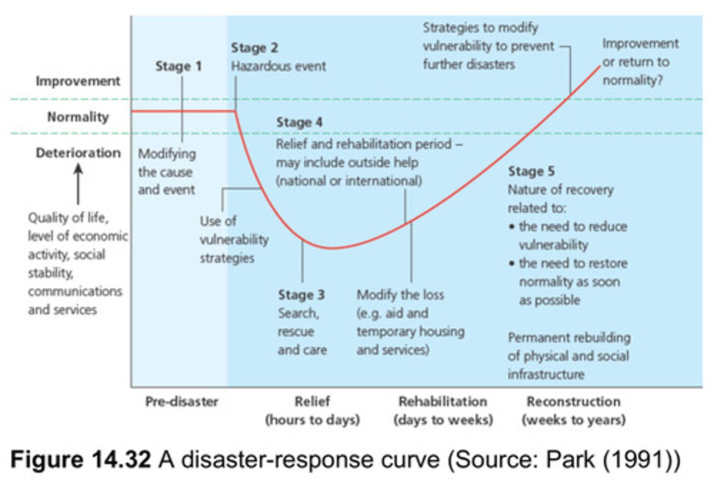
What is stage 1 of the park model?
In this stage, the quality of life is normal before disaster strikes, people try their best to prevent and prepare if such events should happen by either educating the public on how to act when disaster strikes, prepare supplies, putting medical teams on standby etc.
What is stage 2 of the park model?
This stage happens when the event happens, immediately the quality of life rapidly drops, and people use protection and prevention methods such as putting barricades, evacuating people, building trenches to stop water, lava etc.
What is stage 3 of the park model?
After the incident has occurred, this is the period of time followed with stage 2 called relief where medical attention, rescue services and overall care is given out, This period in time can last from days to weeks. The quality of life has seemingly stopped decreasing and beginning to slowly move up.
What is stage 4/5 of the park model?
This stage is called the rehabilitation stage, where people try to return the state of things back to normal, by providing food, water and shelter for those who are derived from those basic needs. Stage 5 moves to the reconstruction period where infrastructure, crops and property are reconstructed or regrown. During this stage people use preparation and prevention to improve from the mistakes of this disaster to respond better to the next one.
What are the further stages of the park model?
In future stages, people will use preparation or prevention to either return to the state before the disaster struck or improve themselves even further and do much better coping with any other future disasters.
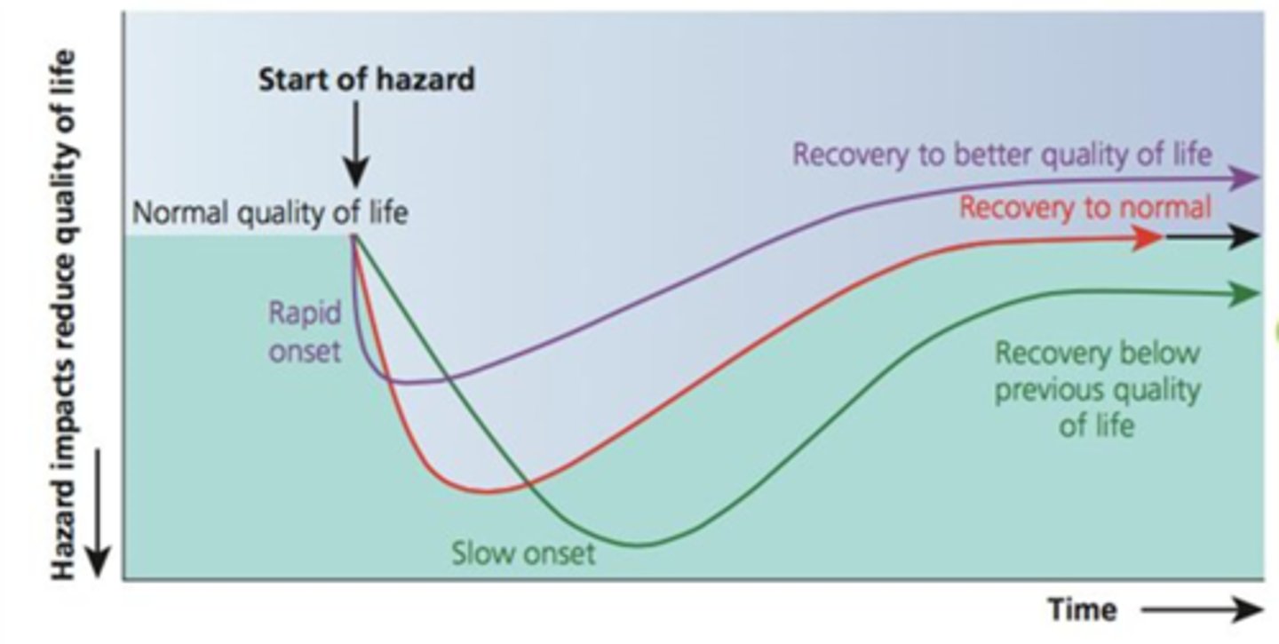
What do each of the different curves of the Park Model suggest about hazards?
Wealthier countries will also have different shaped curves compared to poorer countries, as they will be able to recover much faster.
These different curves will be shown by the speed of the drop in the quality of life, the duration of the decline, and the speed and nature of recovery.
The difference in the three lines on this model could be related to the types of hazard, the degree of preparedness or the speed of the relief effort, and the nature and recovery and rebuilding.
What are 2 strengths of the park model?
The Park Model shows how impacts and responses progress during a disaster, it is a useful tool to analyse the different types of response and the sequence in which they happen.
Park's model is useful in helping to plan the kinds of response need at different stages of tectonic disaster or event, and well as helping planners prepare for future hazard events.
What are 2 limitations of the park model?
Models in Geography are a very simplistic, generalised way of showing impacts and responses to a hazard. Every hazard is different and requires different responses: the model doesn't show the difficulties or intricacies of this.
The Park Model doesn't show spatial variations within a country and assumes everywhere within the country will recover at the same rate. Different areas within a country can be impacted differently and therefore respond differently.
What is the hazard management cycle?
It's a cycle because hazard events keep happening so efforts to prepare for them or mitigate their effects is ongoing.
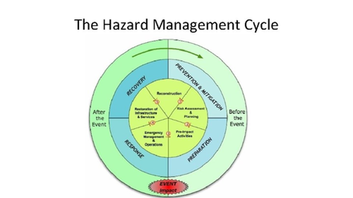
What is preparedness?
This is about planning how to respond to a hazard. This occurs before a hazard takes place.
What is response?
This is how people react when a disaster occurs. This occurs during and immediately after a hazard event.
What is recovery?
This is about getting the affected areas back to normal. This occurs after a hazard event focusing on the long term.
What is mitigation?
Aims to minimise the impacts of future disasters. This occurs before a hazard takes place or afterwards, when the area is recovering.
What mini case study example has followed the hazard - management cycle?
Building back better, Nepal after 2015 7.8 magnitude earthquake.
What are the 6 layers of the Earth's structure?
Inner core
Outer core
Mantle
Asthenosphere
Lithosphere
Crust
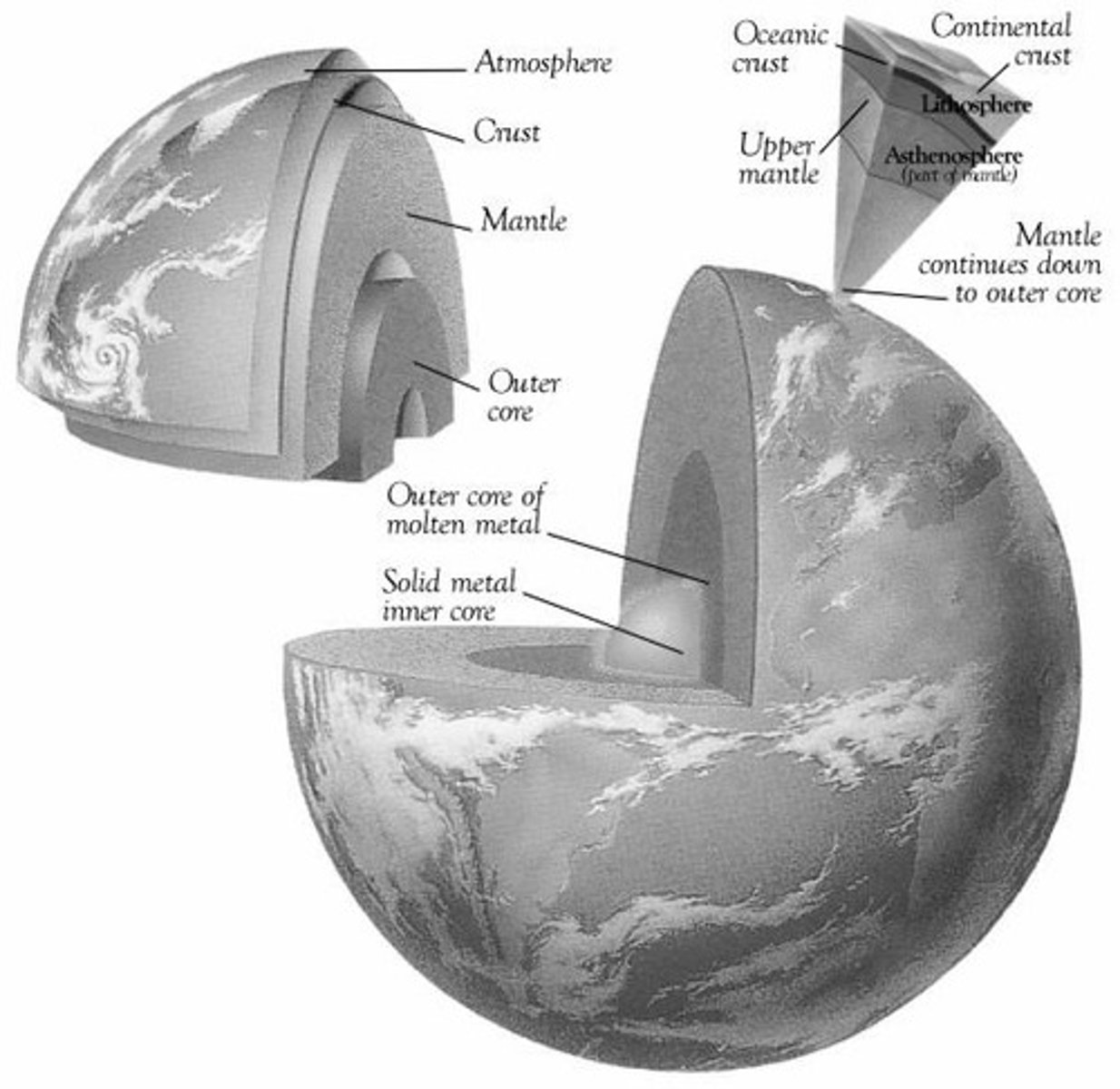
What is the core?
made up of dense rocks containing iron and nickel alloys
over 5000°C
heat is produced as primordial heat and radiogenic heat
What is the mantle?
made up of molten and semi-molten rocks containing lighter elements such as silicon and oxygen
What is the crust?
Even lighter because of the elements present: silicon, oxygen, aluminium, potassium and sodium.
There is oceanic and continental crust.
What is continental crust?
30-70km thick.
Over 1,500,000,000 years old.
Density: 2.6 (lighter).
It is composed of mainly granite; silicon; aluminium; oxygen.
What is oceanic crust?
6-10km thick.
Less than 200,000,000 years old.
Density: 3.0 (heavier).
It is composed of mainly basalt; silicon; magnesium; oxygen.
What is the lithosphere?
Consists of the crust and rigid upper section of the mantle.
Approx. 80-90km thick.
Split into a number of tectonic plates.
What is the asthenosphere?
Lies beneath the lithosphere and is semi-molten on which plates float and move.
What is plate tectonic theory?
The theory that the Earth's crust is divided into plates that move around on the top of the mantle.
What is the theory of continental drift?
A German, Alfred Wegener, published his theory of Pangea, a single continent existing about 300,000,000 years ago in 1912.
This split into Laurasia to the North and Gondwanaland in the South.
Today's continents split from Gondwanaland and Laurasia.
What is geological evidence to support Wegener's theory of continental drift?
The above-mentioned fit of South America and west Africa.
Evidence of a late-Carboniferous glaciation (290 million years ago), deposits from which are found in South America, Antarctica and India. The formation of these deposits cannot be explained by their present position; they must have been formed together and then moved. There are also striations on rocks in Brazil and West Africa which point to a similar situation.
Rock sequences in Northern Scotland closely agree with those found in Eastern Canada, indicating that they were laid down under the same conditions in one location.
What is biological evidence for Wegener's theory of continental drift?
Fossil brachiopods found in Indian limestone are comparable with similar fossils in Australia.
Fossil remains of the reptile Mesosaurus are found in both South America and southern Africa. It is unlikely that the same reptile could have developed in both areas or that it could have migrated across the Atlantic.
The fossilised remains of a plant which existed when coal was being formed have been located only in India and Antarctica.
Why was Wegener's idea of continental drift not popular at first?
WW1
His theory was unable to explain how continental movement could have taken place and his ideas gained little ground.
When was Wegener's idea of continental drift revisited?
1940's onwards
What is sea-floor spreading?
The process where new oceanic crust is formed at mid-ocean ridges through volcanic activity and then gradually moves away from the ridge. Developed by Harry Hess, it occurs at constructive (divergent) plate boundaries, driving continental drift as molten magma rises, cools, and pushes existing tectonic plates apart.
How do we know plates are being destroyed?
Sea-floor spreading implies the Earth is getting bigger. As this is not the case, plates must be being destroyed. Evidence was found that this was through subduction.
What is subduction?
The process by which one plate is driven beneath another plate to form such features as ocean trenches at destructive/ convergent plate boundaries.
How do convection currents cause plates to move?
Heat from the Earth's core drives convection currents in the asthenosphere, causing magma to rise, spread, cool, and sink, moving the crustal plates that float above it. New crust forms at constructive (divergent) boundaries, while old crust is destroyed at destructive (convergent) boundaries. At conservative margins, plates slide past each other with no crust created or destroyed, and no subduction or volcanic activity.
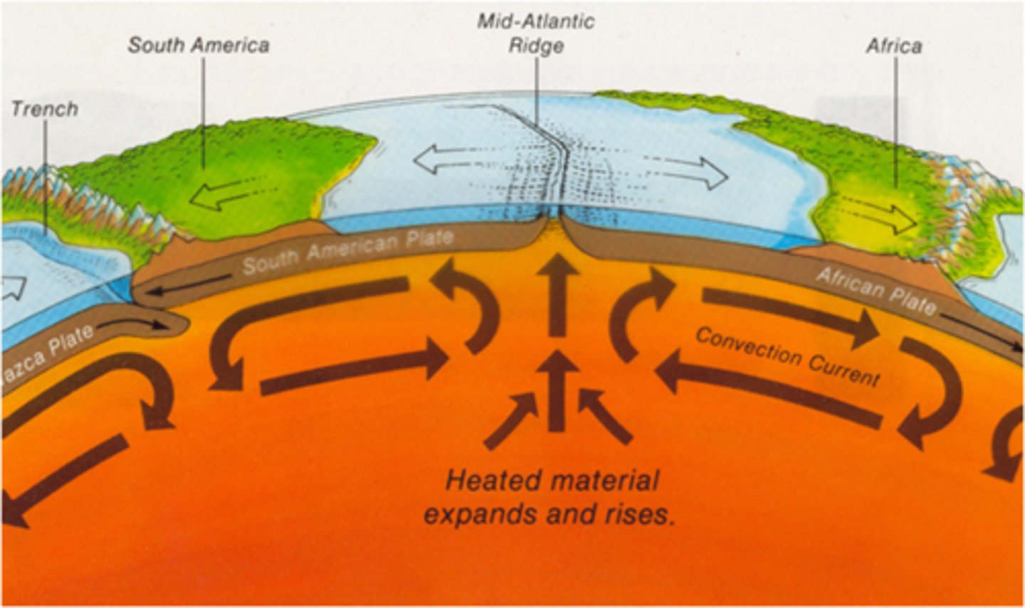
What is a constructive (divergent) plate boundary?
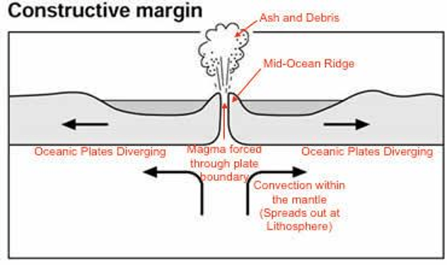
What are features of a constructive (divergent) plate boundary?
Mid-ocean ridges (undersea mountain ranges) and rift valleys.
Where is an example of a constructive (divergent) plate boundary?
The Mid-Atlantic Ridge
What is a destructive (convergent) plate boundary?
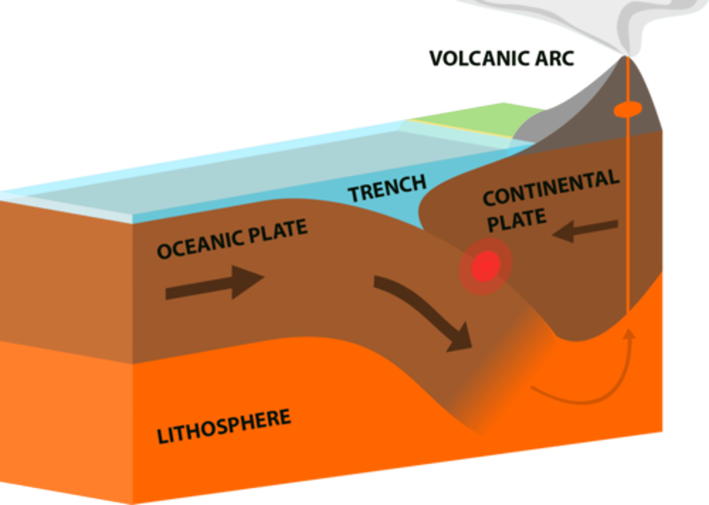
What are features of a destructive (convergent) plate boundary?
Deep sea trenches, volcanic island arcs, and large mountain ranges (e.g., Himalayas) form.
Where is an example of a destructive (convergent) plate boundary?
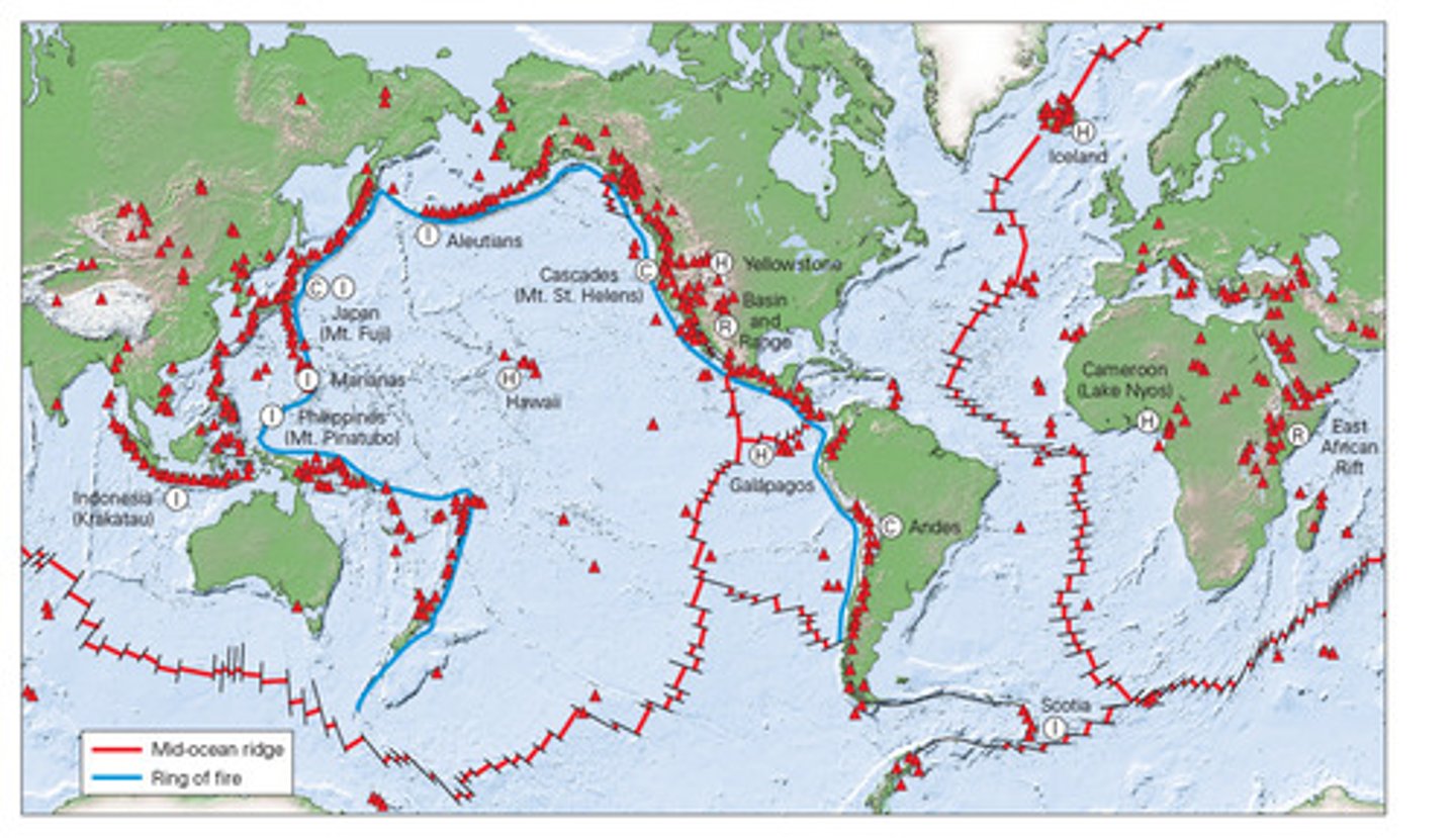
The Pacific Ring of Fire
What is a conservative plate boundary?
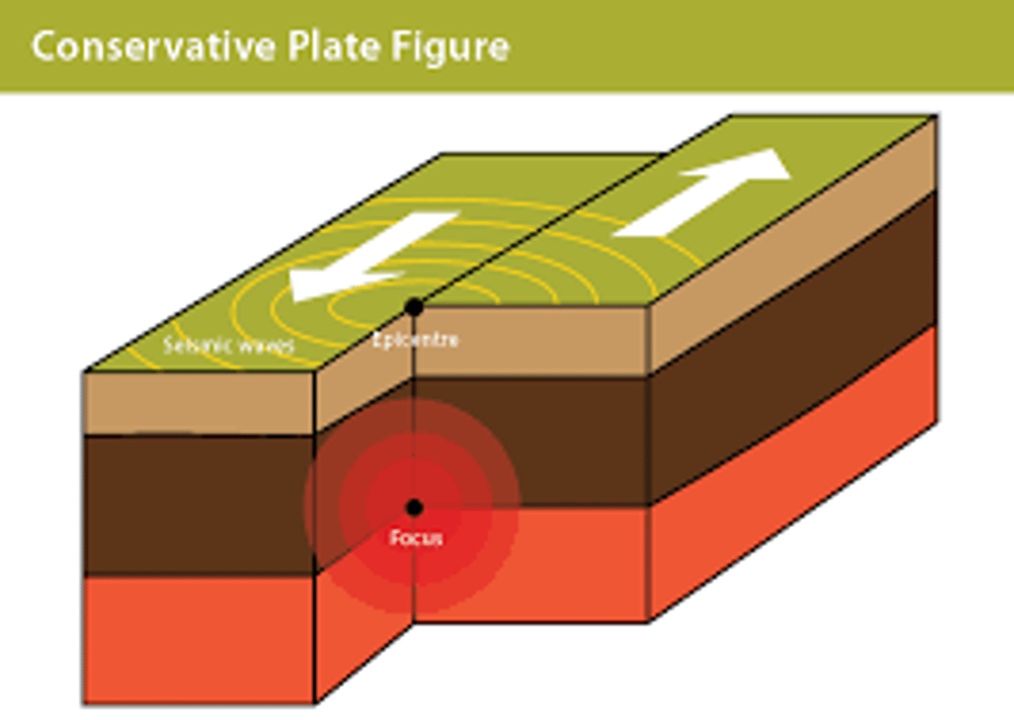
What are features of a conservative plate boundary?
Intense earthquakes, linear fault valleys, and offset landscapes.
Where is an example of a conservative plate boundary?
The San Andreas Fault Zone.
What 6 landforms are associated with plate movements?
Ocean ridges
Rift valleys
Deep sea trenches
Island arcs
Young fold mountains
Volcanoes
How are ocean ridges formed?
Formed when plates move apart in oceanic areas.
The space between the plates is filled with basaltic lava upwelling from below to form a ridge.
Volcanic activity can occur along these ridges: this can form submarine volcanoes e.g. Surtsey to the south of Iceland.
How are rift valleys formed?
Formed when plates move apart on continental areas.
E.g. in eastern Africa, the brittle crust fractures as sections of it move apart. Areas of crust drop down between the parallel faults to form the valley and then a horst is formed (upstanding block between 2 parallel rift valleys).
How are deep sea trenches formed?
Where oceanic and continental plates meet, the denser oceanic plate is forced underneath the lighter continental one (subduction).
The downwarping of the oceanic plate forms a very deep part of the ocean known as a trench.
E.g. the Nazca plate subducted under the South American plate forming the Peru-Chile trench.
A similar process happens when two oceanic plates move towards each other.
E.g. the Pacific plate subducts beneath the smaller Philippine plate to form the very deep Marianas trench.
How are island arcs formed?
During subduction, the descending plate heats up from surrounding temperatures and friction, causing it to melt; the less dense magma rises as plutons and eventually forms complex, explosive composite volcanoes at the surface. If this occurs offshore, it creates a chain of volcanic islands (island arcs).
E.g. The Marianas Islands and Guam
How are young fold mountains formed?
Continental plates are less dense than underlying layers, so little subduction occurs when they collide; instead, their edges and intervening sediments are compressed into fold mountains, with no volcanic activity, while material is forced downward to form deep mountain roots.
E.g. the Himalayas (Asia), Andes (South America), Alps (Europe), and the Rocky Mountains (North America)
What is ridge push?
Newly-formed plates at oceanic ridges are warm, and so have a higher elevation at the oceanic ridge than the colder, more dense plate material further away; gravity causes the higher plate at the ridge to push away the lithosphere that lies further from the ridge.
What is slab pull?
Older, colder plates sink at subduction zones because as they cool, they become more dense than the underlying mantle - so the sinking plate pulls the rest of the plate along behind.
What should ridge push be known as?
Gravitational sliding.
What is gravitational sliding?
At constructive (divergent) plate boundaries, plates move apart, creating tension that allows hot, buoyant magma to rise and form mid-ocean ridges. As this new rock cools, it becomes denser and subsides, causing gravity-driven sliding of the lithosphere away from the ridge (ridge push). As older lithosphere moves aside, more magma rises to form new lithosphere, and computer models suggest this cooling and subsiding rock helps drive plate movement.
What are lahars?
These are formed by volcanic ash mixing with water and flowing downhill. Essentially they are volcanic mudfows.
What is lava?
Molten rock (magma) flowing onto the surface. Acid lava solidifies very quickly, but basic lava (basaltic) tends to flow some distance before solidifying.
What are pyroclastic flows?
Also known as nuées ardentes, formed from a mixture of hot gas (over 800°C) and tephra. After ejection from the volcano, they can flow down the sides of a mountain at speeds of over 700km/hr.
What is tephra?
The solid matter ejected by a volcano into the air. It ranges from volcanic bombs (large) to ash (fine)
At what 4 sites can volcanic activity be found?
Oceanic ridges
Subduction zones
Rift valleys
Hot spots
How does volcanic activity occur along oceanic ridges?
Sea-floor spreading
E.g. mid-atlantic ridge where Iceland represents a large area formed by volcanic activity,
Volcanoes formed here have fairly gentle sides due to low viscosity of basaltic lava.
Frequent, effusive eruptions
How does volcanic activity occur on or near subduction zones?
During subduction, the descending oceanic plate heats up with depth and friction, melting in the Benioff zone; the less dense magma rises as plutons and forms volcanoes. Its viscous andesitic lava produces complex, explosive composite volcanoes, and if eruptions occur offshore, island arcs form e.g. the West Indies.
How is volcanic activity associated with rift valleys?
When rift valleys form, the crust is much thinner than neighbouring areas, suggesting that tension in the crust is causing the plate to thin as it starts to split. Magma forces itself through thinning crust to form volcanoes.
How does volcanic activity occur over hot spots?
In certain places, a concentration of radioactive elements below the crust causes a hot spot to develop. From this, a plume of magma rise to into the plate above and when this lava breaks through the plate, active shield volcanoes form above the spot.
E.g. Hawaiian Islands.
What is a shield volcano?
Shape: Large, wide volcanoes with gently sloping sides, resembling a warrior's shield.
Eruption Style: Effusive (runny) lava flows that can travel long distances.
Formation: Formed by low-viscosity, basaltic lava, often found at constructive plate boundaries or hotspots.
Examples: Mauna Loa and Mauna Kea (Hawaii)
What is a composite volcano?
Shape: Steep-sided, tall, and symmetrical cones.
Eruption Style: Explosive, violent eruptions due to thick, viscous magma that traps gas.
Formation: Created at destructive (subduction) plate boundaries where oceanic crust melts.
Examples: Mount St. Helens (USA), Mount Etna (Sicily), Mount Fuji (Japan).
How are volcanoes distributed?
Clear relationship between volcanoes and tectonic margins.
The 40,000km "Ring of Fire" shows high densities of volcanoes around the edge of the Pacific Plate, especially around Japan and Indonesia.
Volcanic activity is present at constructive and destructive subduction boundaries but absent at conservative.
Volcanism can also occur within the centre of plates, such the Hawaiian hot spot.
Where are composite volcanoes located and how does this affect the frequency of eruptions?
Located on destructive plate margins.
Tend to erupt infrequently due to the viscous nature of rhyolitic or andesitic magma.
Plates descend deep into the mantle and melt due to the surrounding heat and friction from the subduction process. The less dense magma, rich in silica formed here, rises to the surface to create composite volcanoes with a gaseous, explosive nature.
The accumulating layers of lava - ash - lava - ash ... gives these volcanoes their name ('composed' of many layers).
Where are shield volcanoes located and how does this affect the frequency of eruptions?
Located on constructive plate margins or hotspots.
Tend to erupt frequently due to the fluid nature of basaltic magma.
Over a hotspot, hot and runny basaltic magma rises and breaks through at the surface. The lava travels long distances before it cools forming low, wide volcanoes (like a 'shield' lying on the ground).
What is rhyolitic lava?
Highest viscosity & highest content of silica (65-75%) .
Flows slower than andesitic & basaltic lava .
Ooze from erupting stratovolcanoes after violent pyroclastic flows.
What is andesitic lava?
High viscosity (thick) lava found destructive plate boundaries.
Gases are trapped in magma, meaning eruptions are usually infrequent but explosive and high risk.
What is basaltic lava?
Very hot.
Low viscosity frequent eruptions that go on for a long time.
Not very violent.
How is the magnitude of volcanoes measured?
Using the Volcano Explosivity Index.