weather 2
1/30
There's no tags or description
Looks like no tags are added yet.
Name | Mastery | Learn | Test | Matching | Spaced | Call with Kai |
|---|
No analytics yet
Send a link to your students to track their progress
31 Terms
What is an air mass
Large body of air , with same air pressure and temp throughout it. Often thousands of km wide

Tropical maritime in the British isles
South Atlantic Ocean |very common |
Tropical maritime air is warm and moist and during its passage over the Atlantic Ocean it becomes increasingly saturated. When a tropical maritime air mass reaches the British Isles it brings with it low cloud, drizzle and fog. Tropical maritime air brings mild winter conditions and warm summers to the British Isles.
Polar maritime (Pm) | most common | nort
Polar maritime
northern Canada and Greenland and travels over Atlantic Ocean |most common
brings cold weather with frequent heavy showers.
Tropical Continental
North Africa and the Sahara | Rare and usually occurs in summer
brings very hot and dry conditions to British Isles. may cause thunderstorms if temperature is very high.
Polar continental
Eastern Europe and Russia | More common in winter than summer
Very cold, dry conditions in winter. Sometimes brings snowfall to eastern part of UK
mild, dry conditions in the summer
Artic
Arctic | rare
Exceptionally cold. may produce hail showers or snow over Scotland and along coasts exposed to northerly winds.
What anticyclone look like on synoptic chart:
Isobars widely spaced
Highest air pressure in centre
No fronts
Winds blow clockwise direction from centre of direction towards the system's edge
Very little cloud cover/ sometimes fog or sky obscured and generally dry
Calm conditions/ gentle winds
Temperatures - very high in summer and very low in winter

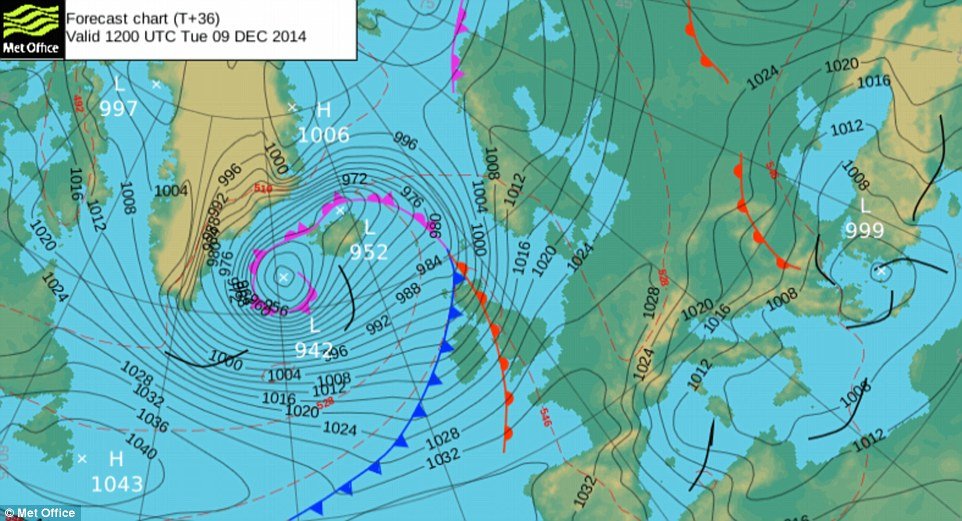
What mid latitude depression looks on synoptic chart
Isobars close together
lowest air pressure in centre
Fronts - warm, cold and occluded
Winds blow in anticclockwise direction from the edge of the system towards the centre
Thick cloud cover with rainfall close to the fronts
Windy condition/ Strong wind
Temperatures - mild in summer and moderate in winter/ variation in temprature within the system
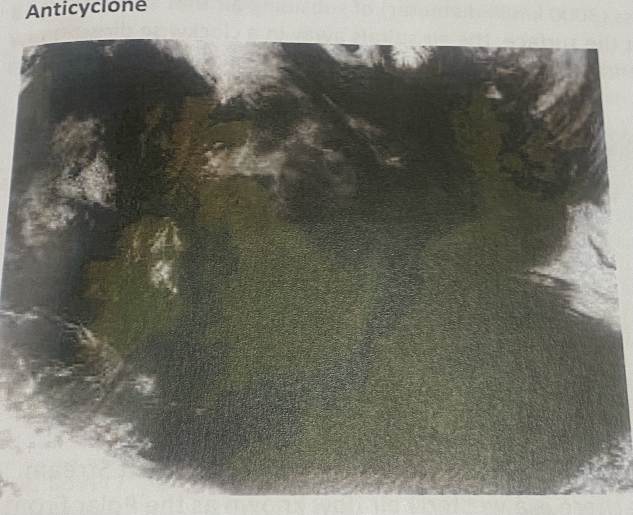
Anticyclone satellite imagery
Lack of cloud cover
Land and sea are visible
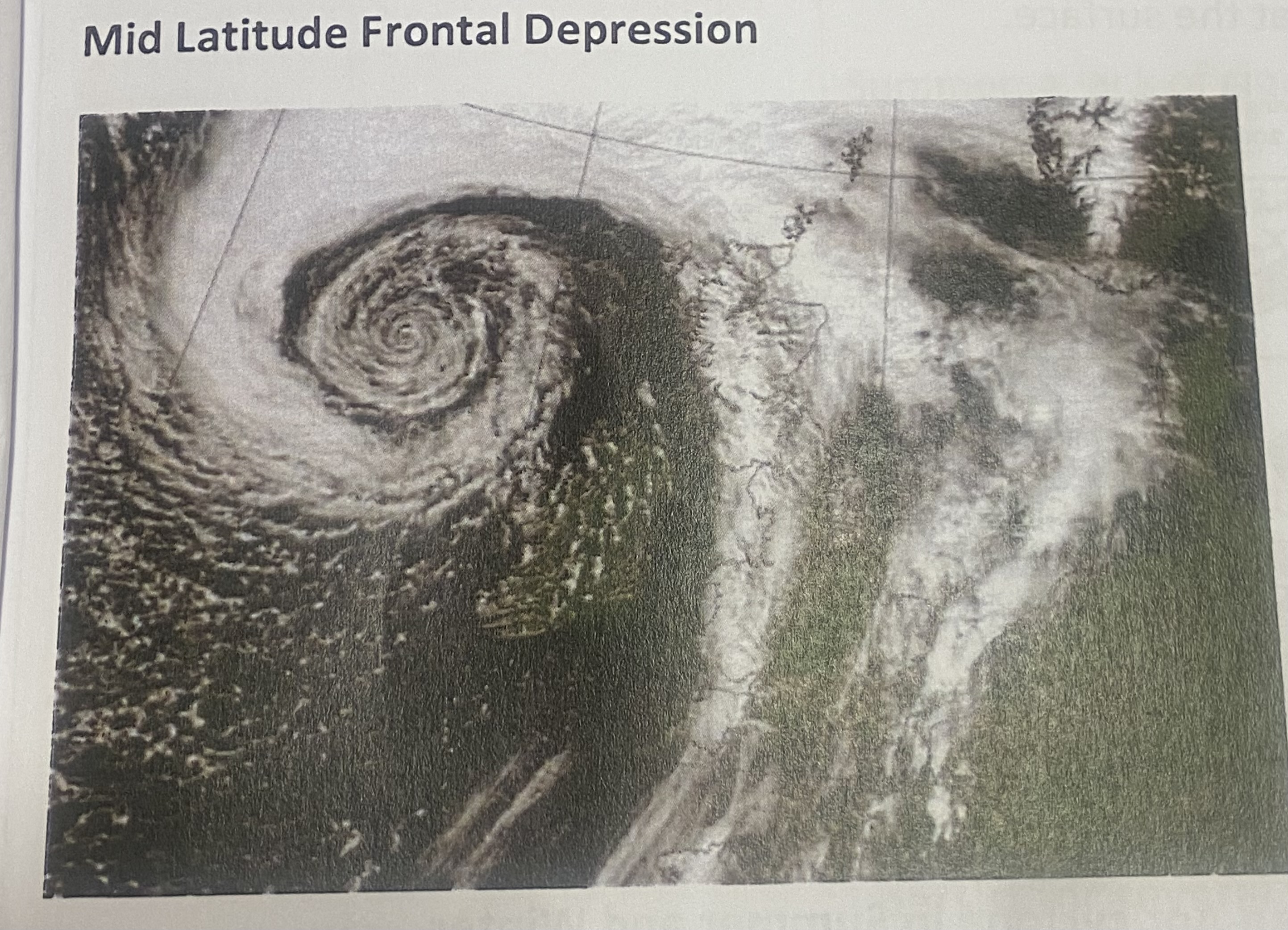
Depression satellite imagery
White swirling band of cloud
Land and sea are not as visible
how are anticyclones formed
Form large mass (3000km in diameter) of subsiding air spirals from troposphere to ground surface, surface air spirals away in clockwise direction ,
Form tropical continental/ polar continental air mass
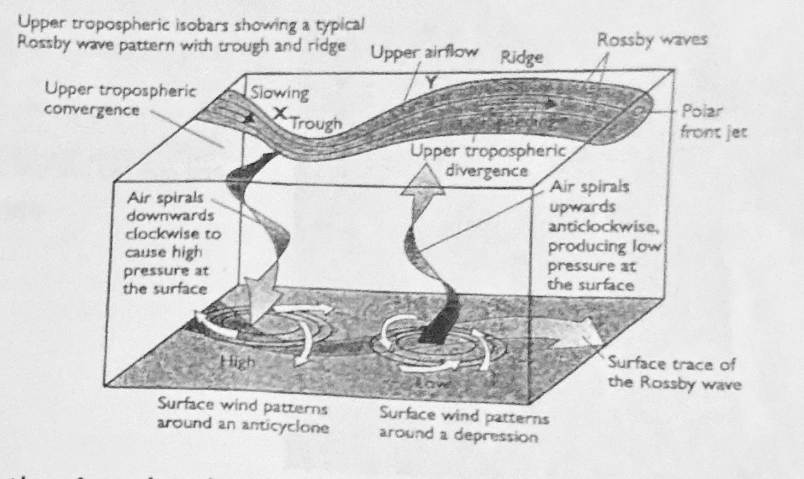
Anticyclones forming from polar front jet stream
convergence of air aloft in Polar Front Jet Stream.
westerly air flow waves known as Rossby Waves. When air flow in Polar Front Jet Stream approaches trough and flows towards lower latitudes, tends slow down and converg aloft causes air to spiral downwards towards surface. descending air creates high air pressure at surface.
What is anticyclone weather like
Settled weather may persist for days/ weeks
Air pressure high slow moving can persist several days/ even weeks if they become detached from upper westerly air flow when Rossby waves are pronounced (blocking anticyclone)
Air pressure
High | air flows towards equator in troposphere (upper atmosphere), it slows down and a large mass of air converges (piles up) aloft. This air pushes downwards towards Earth’s surface to create high pressure at surface.
Sunshine
Summer – long hours, Winter – short hours
Cloudless skies due to air subsiding. Longer hours of sunshine in summer as Northern Hemisphere is tilted towards the sun leading to longer days.
Cloud cover/ Rainfall/ Fog |
Clear skies/ little cloud cover/ fog/ little rainfall |
source of air is upper atmosphere where very little moisture so air is dry. As air subsides, it is compressed, warmed, its relative humidity decreases so condensation will not happen and cloud formation is suppressed.
Summer: a lack of cloud cover results in a loss of heat energy by radiation cooling. The ground surface may become cold enough to chill the air above it enough to cause condensation of the water vapour and the formation of an early morning mist. This mist dissipates when temperature rises.
Winter: little insolation is received so the ground becomes extremely cold. With very little wind, the air sits above the ground long enough to be cooled by it. When dew point is reached, condensation happens and a fog forms at ground level. With the weak winter sun, low temperatures will be experienced during the day and the night so this fog may persist for several days.
Temperature In Summer
high temperatures/ heatwave conditions | The Northern Hemisphere is tilted towards the sun so receives more insolation. The sun’s rays travel more directly through the earth’s atmosphere so energy losses are lower. There is also little cloud cover to reflect/ absorb/ scatter insolation. The insolation is also concentrated on a smaller area of land so the surface is heated more intensely. Nights are shorter and days are longer so maximum insolation is received and day time temperatures will be high. Nights will be cooler as heat escapes through cloudless skies.
Temperature In Winter
low/ sub-zero temperatures | The Northern Hemisphere is tilted away the sun so receives less insolation. The sun’s rays journey through the earth’s atmosphere is longer so energy losses are higher. The insolation is also concentrated on a larger area of land so the surface is heated less intensely. Nights are longer and days are shorter. Temperatures will be low and at night time they will drop to/ below 0°C as heat is lost through cloudless skies.
Wind Speed/ Wind Direction
Calm/ light winds |
same air mass throughout anticyclone (tropical continental/ polar continental) so gentle pressure gradient i.e. air pressure varies little. Air spirals outwards from high air pressure in centre of system towards lower air pressure at its edge (Pressure Gradient Force) and is deflected to the right (Coriolis Force) to create winds blowing in a clockwise direction.
Formation of Depressions
takes about a week from their form in the Atlantic Ocean to their decay to the north east of the British Isles.
Depressions form where a polar maritime air-mass converdoc meets a tronical maritimo air mass.
These air-mass do not mix easily so when they a boundary called a front develops between them.
There is a steep pressure gradient due to the temperature variation within a depression. At the surface. the air spirals in an anticlockwise direction from the high pressure at the edao of the depression to the lower air pressure at its centre. When the air in the Polar Front Jet Stream moves out of a trough towards the Polar latitudes, it accelerates and diverges. Air is drawn up, in an anticlockwise spiralling motion, from the lower atmosphere causing a low pressure depression at the earth's surface.
The Tropical Maritime air-mass forms over the South Atlantic where it is heated and absorbs moisture. During its passage over the Atlantic Ocean it picks up even more moisture. The polar maritime air mass forms over northern Canada and Greenland. It is much colder and contains less moisture.
Since these two air masses do not mix, the less dense tropical maritime air mass begins to rise over colder, denser Polar Maritime air mass. As the warmer air rises over the colder air, the tropical the polar maritime air fills in the space that the warmer air mass used to cover before it began rising and begins to undercut the warm tropical maritime air. In this way, the warm sector is gradually reduced in area until the cold air has pushed the warm air off the ground surface. When this happens, an occluded front begins to develop and the depression has started to decay.
Structure of a Depression
Steep pressure gradient across weather system with air pressure falling towards the centre of the depression
Two air masses - tropical maritime and polar maritime so there is a huge contrast in temperature
Two fronts mark the boundary between the tropical maritime and polar maritime air masses.
Warm Front is in front of the small wedge of tropical maritime air. Here the less dense tropical maritime air rises over the polar maritime air and rainfall is steady.
Cold Front is in front of the polar maritime air. Here the tropical maritime air is undercut by cold polar which forces the tropical maritime air to rise. Towering cumulonimbus clouds and
Between the warm front and the cold front is the warm sector composed of tropical maritime air
Surrounding the warm sector is polar maritime air.
General Weather in depression
Changeable/ unsettled weather |
Air pressure is low so depressions pass over the British Isles quickly. They are formed from two air masses with high moisture content but different temperature characteristics so weather is changeable.
Air pressure in depression
LOW/ CHANGEABLE
Approach – steady fall
Warm front– fall stops
Warm sector - steady low
Cold front - sharp rise
After Cold front - rises- slowly
Air pressure is changeable depending on which part of the depression/ air mass is affecting the surface. In general depressions are low pressure systems as tropical maritime air rises over the polar maritime air to create low pressure at the ground surface.
Cloud cover/ Rainfall- depression
CHANGEABLE
Approach – high, thin cloud with no rainfall.
Polar maritime air mass has high levels of humidity due to evaporation of moisture on its long journey over the Atlantic Ocean. Tropical Maritime air is warm and has absorbed huge quantities of moisture as it travelled over the Atlantic Ocean from the Azores/ the Caribbean.
warm front – low thick cloud with continuous and quite heavy rainfall
At the warm front – warm tropical maritime air rises over a wedge of cold polar maritime air. Warm air expands and cools as it rises, its relative humidity increases, dew point is reached. Further uplift of air means condensation occurs and clouds/ rainfall form.
warm sector – low cloud/ none with drizzle/ no rainfall
In warm sector – little rainfall because this is tropical maritime air which is warm so a large volume of moisture can be held as water vapour
cold front – thick, towering cumulonimbus clouds, with heavy/ intense rainfall
At cold front – warm air is undercut by a wedge of cold polar air. As warm air is undercut and forced to rise, it expands, cools, its relative humidity increases, dewpoint is reached. Further uplift of air means condensation occurs and towering cumulonimbus rain bearing clouds form to bring intense and heavy rainfall.
After CF – cloud decreasing but some heavy showers
After the cold front has passed, the second cold sector arrives. The polar maritime air is sinking/ subsiding so cloud formation is suppressed
Temperature In depress
Approach – 6°C
WF – sharp rise
WS – warm mild 10°C
CF – sharp fall
After CF – cold 3°C | Cloud cover prevents extreme high and low daytime/ night time temperatures in both winter and summer.
Polar maritime air brings lower temperatures.
Tropical maritime air brings higher temperatures.
Sunshine In depression
Very little | In general, there will be little in the way of sunshine due to the cloud cover. A little more sunshine when the warm sector is overhead as there is less cloud cover.
Wind Speed/ Wind Direction in depression
Fast winds - anticlockwise direction
Approach – SSE slow but increasing
WF – SSE/ SW strong
WS – SW slower
CF – SW/NW strong
After CF – NW slowing | Polar maritime air mass / tropical maritime air mass. Temperature and pressure characteristics differ especially at the fronts. This creates a very steep pressure gradient. Air spirals inwards from the high air pressure at the edge of the system towards the low air pressure at its centre (Pressure Gradient Force) and is deflected to the right by the Coriolis Force to create winds blowing in an anticlockwise direction.
THE POLAR FRONT JET STREAM AND THE WEATHER OF THE BRITISH ISLES
Polar Front Jet Stream westerly fast-flowing (200mph) belt of air found 10 km above the earth's surface at approximately 60°N. located between Polar and Ferrel Cells of tri-cellular model. At 60°N, cold air from arctic converges with warm air from tropics. Due to huge difference in temperature and air pressure in the troposphere where these air masses converge, air moves rapidly from high air pressure to low air pressure (pressure gradient force).
The Coriolis is strong due to fast wind speed and deflects the moving air to the right. At this altitude, no friction so a westerly air flow is created. The Polar Front Jet Stream meanders in a series of curves called Rossby Waves. These waves start as the jet stream crosses over the Rocky Mountains. The Polar Front Jet Stream is responsible for steering anticyclones and depressions across the Atlantic Ocean towards the British Isles.
The Polar Front Jet Stream and Summer Weather in the British Isles
typical British summer, jet stream lies to North British Isles. British Isles affected by warm, drier air from Europe and Africa. Mid-latitude depressions are steered towards Scandanavia instead of across the British Isles. In summer if the polar front jet stream lies south of its usual position, the British Isles will experience more frequent depressions and have a colder, wetter summer than usual.
The Polar Front Jet Stream and Winter Weather in the British Isles
winter, jet stream further south of British Isles so brings colder Arctic air from Greenland. more depressions to British Isles weather wetter and windier.
Blocking Anticyclones
If Rossby Waves of Polar front jet stream extreme, blocking anticyclone may control weather of British Isles for extended period. jet stream flows around blocking anticyclone diverts depressions away from British Isles. British Isles fine, settled weather in summer and very cold weather in winter for a prolonged period of weeks, sometimes months.