Coastal Lagoons and Deltas: Formation, Types, and Significance in NZ and Global Contexts
1/81
There's no tags or description
Looks like no tags are added yet.
Name | Mastery | Learn | Test | Matching | Spaced | Call with Kai |
|---|
No analytics yet
Send a link to your students to track their progress
82 Terms
What is a Hapua?
Lagoons that form at the mouths of braided rivers.
What type of beaches do Hapua typically form on?
Mixed sand and gravel (MSG) beaches.
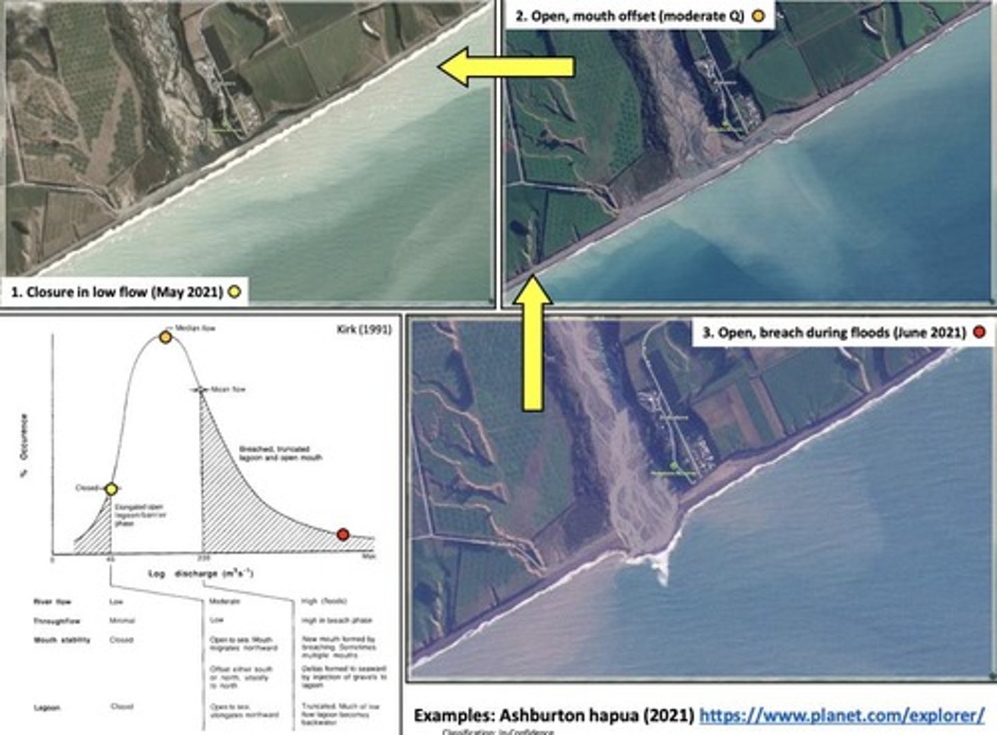
Why are Hapua not usually closed?
Because they have high river energy.
Provide an example of a Hapua.
The Rakaia river mouth.
What is a Waituna?
A freshwater coastal lagoon that is larger and lake-like.
How do Waituna lagoons differ from Hapua in terms of closure duration?
Waituna tend to be closed for longer periods due to smaller rivers flowing into them.
Provide an example of a Waituna.
Te Waihora (Lake Ellesmere).
What are IOCEs?
Intermittently Open/Closed Estuaries, a subset of wave-dominated estuaries.
What is the tidal range like in IOCEs?
They have a very small tidal range.
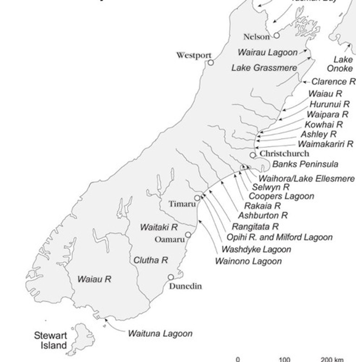
How many Hapua and Waituna are found in the South Island?
Over 40, with the majority being Hapua.
What natural feature provides coarse material to South Island coastal lagoons?
The Southern Alps.
What coastal processes shape the morphology of Hapua and Waituna?
Southerly waves generate northward longshore drift currents.
What is the significance of Hapua and Waituna for native species?
They are important habitats for native flora and fauna, including mahinga kai and taonga species.
What is a major ecological indicator for Hapua?
The health of the catchment ecosystem and the state of the mauri of the river.
What is the primary reason for the erosion of coasts where Hapua exist?
Chronic erosion despite high sediment loads due to fine sediment being easily eroded offshore.
What is wave overwash?
When big waves overtop the barrier to overwash into the hapua lagoon.
What is the case study example of a Hapua mentioned?
Rakaia River hapua.
What is the impact of water abstraction on the Rakaia River?
It has caused habitat degradation and is referred to as 'death by a thousand cuts.'
What happens during high tides at the hapua?
A backwater effect can occur, causing flooding.
What is the largest Waituna lagoon in New Zealand?
Ellesmere.
What is a key factor in deciding to open Waituna lagoons?
Fish mitigation and maintaining water levels for wetland vegetation.
What are the two exceptions of Hapua entering the coast on sandy beaches?
Ashley and Waimakariri hapua.
What is the primary sediment type found in South Island IOCEs?
Mixed sand and gravel.
What is the effect of wave energy from Antarctica on South Island lagoons?
It creates significant longshore drift and sediment transport.
What is the relationship between Hapua and river flow?
Mouth morphology is controlled by wave vs fluvial processes.
What is the primary sediment load delivered during floods according to Kirk (1991)?
Fine sand and silt that is lost via dispersion to the continental shelf.
What is the role of Banks Peninsula in sediment transport?
It refracts wave energy and causes currents to circulate around the bay.
What is the primary reason for the long history of water overallocation in the Rakaia River?
Pressure from irrigation and land use change.
What is the area of Lake Ellesmere?
198 km², making it New Zealand's 5th largest lake.
Why is Lake Ellesmere culturally significant?
It is a tribal taonga for Ngāi Tahu, a major mahinga kai, and an archaeological site.
What is the average depth of Lake Ellesmere?
2-3 meters.
What is progradation in delta formation?
The process where sediment is deposited outward into the water as river flow enters a low-energy waterbody.
What conditions are necessary for progradation to occur?
A surplus sediment supply and a stable or falling sea level.
What distinguishes coastal river deltas from estuaries?
Coastal river deltas have unidirectional flow and sediment transport, while estuaries have tidal exchange.
What is the morphology of the Mississippi River delta?
It has a 'bird's foot' morphology due to strong river flow.
What are the three sedimentary structures of deltas?
Bottomset, foreset, and topset.
What is the significance of boundary conditions for delta formation?
Deltas form best in big rivers with high discharge and sediment loads that enter low-energy ocean basins.
What characterizes wave-dominated deltas?
They have a seaward margin modified by wave action, often featuring mouth bars and lagoons.
What is the Relative Tidal Range (RTR) for a wave-dominated delta?
An RTR under 3 is considered wave-dominated.
What is a key feature of tide-dominated deltas?
They exhibit tidal mudflats and have a higher number of channels than wave-dominated deltas.
What is the population density of the Ganges delta?
Approximately 200 people per km², with a total population of around 280 million.
What challenges does the Ganges delta face?
It is threatened by subsidence, sea level rise, and saline intrusion affecting agriculture and drinking water.
What is the significance of the Nile River delta?
It supports 18 million people and has a classic cuspate shape, but is under threat from erosion and sea level rise.
What is the impact of the Aswan High Dam on the Nile delta?
It holds back 98% of sediment, leading to erosion at the delta front.
What is the primary morphology of river-dominated deltas?
They have a 'birds foot' morphology and exhibit delta-lobe progradation.
What is the Mississippi River delta's drainage basin size?
It covers 3.2 million km², making it the largest drainage basin in North America.
What is the natural cycle of avulsion in the Mississippi River delta?
It has a ~1,000-year cycle of channel abandonment for a more efficient pathway into the Gulf.
What happens to sediment as it enters a delta?
The flow spreads out, decreasing velocity, which reduces its ability to transport sediment, leading to deposition.
What is the ecological significance of Lake Ellesmere?
It supports aquatic and wetland ecosystems but has suffered environmental degradation.
How does sediment delivery to the coast compare to marine processes?
Fluvial sediment is delivered more rapidly than it can be removed by marine processes.
What are the characteristics of a wave-dominated delta?
They have barriers, spits, lagoons, and parallel bars modified by wave action.
What is the impact of sea level rise on delta regions?
It increases base levels, allowing waves and storm surges to reach further inland, threatening agriculture.
What is the significance of sediment load in the Ganges delta?
High sediment loads are due to material from the Tibetan plateau, contributing to delta formation.
What is the average tidal range of the Ganges delta?
Approximately 4 meters, classifying it as macro-meso tidal.
What is the impact of saline intrusion in delta regions?
It affects crops, agriculture, and drinking water safety, increasing soil salinity.
What has evolved over the last 7,000 years through delta cycles?
The Mississippi River delta.
What is the purpose of the Old River Control Complex?
To prevent avulsion by forcing the main flow to stay in the Mississippi River.
What percentage of the world's freshwater discharge does the Amazon Delta account for?
20%.
What happens to the Amazon Delta during floods?
It produces sediment plumes approximately 400 km long and 100 to 200 km wide.
What is shear stress in the context of sand movement?
The force trying to move a sand grain, balanced by resisting stress.
What factors contribute to shear stress?
Velocity of wind, grain size diameter, turbulence coefficient, and angle of rest of grain.
What is resisting stress related to in sand movement?
The density of grain, density of fluid, diameter of grain, and acceleration due to gravity.
What type of dunes align along the net vector of wind flow?
Parabolic dunes.
What are linear dunes formed by?
Bimodal wind systems with limited sand supply.
What are foredune ridges and how are they formed?
Shore-parallel dune ridges formed by aeolian sand deposition within vegetation.
What are the two main types of foredunes?
Incipient foredunes and established foredunes.
How do vegetation stabilize dune surfaces?
By reducing friction drag, holding sand in place, and retaining water.
What is podzolisation?
The process where soils develop on dunes, characterized by porosity and nutrient leaching.
What does curvature measure in relation to erosion rates?
It measures how sediment moves at different slopes, indicating erosion rates.
What is the relationship between dune age and curvature?
Younger dunes are closer to their angle of repose, while older dunes flatten out.
What is the significance of charcoal in dune studies?
It helps understand fire histories and sedimentary records in arid areas.
What was the impact of Māori arrival on Ahuahu island?
Fire use began, altering the sediment records and plant types.
What is the average annual rainfall in Channel Country, SW Queensland?
162.6 mm.
What type of artifacts are found in the Channel Country landscape?
Mithaka (aboriginal nation) artifacts.
What is the main factor affecting the movement of sand grains?
Wind velocity.
What is the role of OSL in geological studies?
Optically stimulated luminescence is used for dating sediments.
What happens to soils as they age on dunes?
They thicken and initially become more nutrient-rich, but nutrient status declines over time.
What is a key characteristic of parabolic dunes?
They are U-shaped and heavily vegetated.
What is the effect of seasonal wind direction on dune profiles?
It causes the depositional side to shift, altering the dune's shape.
What is the significance of sedimentary charcoal records?
They provide insights into fire histories, especially in arid regions.
What is the main environmental factor affecting dune type?
The availability of sand to move.
What is the relationship between wind strength and dune morphology?
Different wind strengths create varying slope angles and dune shapes.