GIS 2
1/22
Earn XP
Description and Tags
Midterm: Mini Quiz Questions
Name | Mastery | Learn | Test | Matching | Spaced | Call with Kai |
|---|
No analytics yet
Send a link to your students to track their progress
23 Terms
If you see cyan blue things all over your map you probably..
forgot to clear a selection after you asked your questions
Select by location allows you to find all features within a set distance of another feature..
true
The expression that places observations into groups through logical statements is written as an expression in a format called..
SQL
This function works like a cookie cutter to truncate features from one feature class based on the shape of another..
buffers
If you selected all the states that bordered PA so they were highlighted and then using that you wanted to remove from that selection those states with populations 5 million, you would..
hold down the selection method and choose “remove from selection”
One of the easiest ways to select something like Pennsylvania from the US states is to use the interactive query tool and select it with the mouse..
True
Buffers can be a simple shape, or as multiple rings, and can be symmetrical or asymmetrical..
True
If you wanted to find all the counties over 50k people you would probably do a spatial query
False
Which of the following is NOT an operator in Boolean logic statements..
@
Which is NOT one of the ways to select features in GIS..
select by expression
An expression that generates a selection of a subset of records based on specific attributes is called a…
attribute query
A type of spatial query that creates a new layer by delineating area that fall within a certain distance
buffers
Buffers can only be done to lines and polygons, you can not create a buffer of a point since it has zero dimensions
False
A task such as '“Finding all the census tracts with an average income greater than $50k AND that are in Cumberland Co” would be using a Boolean Connector
True
Finding all the gas stations within 5 miles of your house would be considered a —— GIS spatial relationship..
proximity
If I selected all the cities within 100 miles of Harrisburg and then wanted to find from that group only the larger populated ones I could..
remove from selection cities < 100,000
If I conducted an analysis to find the area within 50ft of all river beds I would be doing
buffering
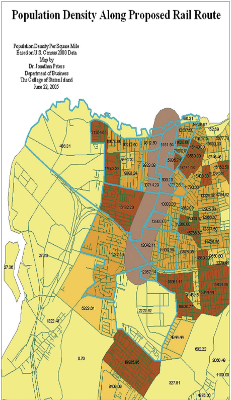
In the following map to identify the population along a proposed trail (the brown polygon), which function did they use..
buffer
What does proximity analysis measure
distance between features
Why should distance-based analysis be performed in a projected coordinate system?
distance calculations may be incorrect in decimal degrees
What is spatial data?
characteristic of data across space
Why is it important to explore your data before spatial analysis?
to avoid incorrect conclusions