Stage 2 Lesson 8 National Airspace
1/26
There's no tags or description
Looks like no tags are added yet.
Name | Mastery | Learn | Test | Matching | Spaced | Call with Kai |
|---|
No analytics yet
Send a link to your students to track their progress
27 Terms
What is controlled airspace?
generic term that covers the different classifications of airspace and defined dimension within which air traffic control (ATC) service is provided in accordance with the airspace classification
Controlled airspaces consist of:
Class A
Class B
Class C
Class D
Class E
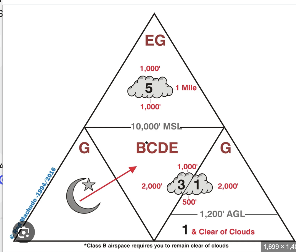
Draw the weather Minimum triangle for the airspaces.
Describe class A airspace. Dimension and Requirements
Generally the airspace from 18,000 feet mean sea level (MSL) up to and including flight level (FL) 60
This concludes the airspace overlying the water within 12 nautical miles of the coast of the 48 contiguous states and Alaska
Everywhere, and is over all other airspace
Has no depictions
Requirements for operating in airspace:
Equipment needed: 2 way-radio, mode C, and ADS-B Out
Unless otherwise authorized, all operations in class A airspace is conducted under instrument flight rules (IFR)
Mach one is airspeed
No weather minimums because you have instrument flight plan
Pilot needs to have an IFR rating
Describe class B airspace. Dimension, Depiction and Requirements
Typically airspace from the surface to 10,000 feet MSL surrounding the nation's busiest airports in terms of airport operations or passenger enplanements
Bravo = Big
Each Class B airspace are is individually tailored
Some class B airspace areas resemble upside-down wedding cake, but can be fully customizable
Surface to 10,000 MSL (usually)
Depiction: Solid Blue line
Requirements for operating in airspace:
Need a student pilot with a an endorsement
Two-way radio communication-must hear your tail number to enter
ATC Clearance is required for all aircraft that are so cleared receive separation services within the airspace
Mode C transponder
ADS-B Out
Under 10,000ft MSL must not exceed 250 knots
Beneath bravo is 200 knots
3 statute miles of visibility and remain clear of clouds
Describe class C airspace. Dimension, depiction and Requirements
Generally airspace from the surface to 4,000 feet above the airport elevation surrounding those airports
they have a full time operational control tower, are survived by a radar approach control, and have certain number of IFR operations or passenger enplanements
Individually tailored
the airspace usually consists of a surface are with a five NM radius, an outer circle with a ten NM radius that extends form 1,200 feet to 4,000 feet above the airport elevation
Offer IFR and VFR seperation
VFR traffic Advisories workload permitting
Depiction: Magenta solid line
Requirements for operating in airspace:
Two-way radio
Mode C transponder (Charlie is Mode C)
ADS-B Out
At or below 10,000 feet 250 knots
Need a student pilot certificate
Describe class D airspace. Dimension, Depiction, and Requirements
Generally airspace from the surface to 2,500 feet above the airport elevation surrounding those airports that have a Part time operational control tower
Depicted as: Delta-Dashed - Dashed blue line
Requirements for operating in airspace:
Two way radio communication: “must hear our tail number”
They might respond to you without tail number but that does not mean you are cleared to enter
Just need a student pilot cert is needed to enter
Describe class E airspace. Dimension, Depiction and Requirements
Controlled airspace that is not classified as Class A, B, C, or D
Large amount of the airspace over the United States is designated as Class E airspace
“Everything else and everything else”
Provides sufficient airspace for the safe control and separation of aircraft during IFR operations
Depiction: Where does Class E Start? - Typically extends to but not including 18,000MSL and then starts again above FL60
In areas where charts do not depict a class E base, class E begins at 14,500 feet MSL
Dashed magenta line → Class E starts at the surface
Faded magenta vignette → Class E starts at 700 AGL
Faded blue vignette → Class G starts up to 14,500MSL (really only in Alaska)
Requirements for operating in airspace:
Below 10,000ft no requirement on equipment and speeds below 250 knots
At 10,000 need ADS-B out and Transponders
Help with traffic, faster planes
Echo within 30 nautical miles Bravo airspace
Required over airspace of bravo and charlie
Underneath a shelf of bravo airspace drop under 200 knots
What are the different types of Class E airspaces?
SETVODA
surface- starts surface (dash magenta)
Extension - protecting approach (dashed magenta)
Transition - 700agl (shaded magenta )
Victor airways
Offshore- varies with area blue zipper altitude listed in msl
Domestic in route? - starts at 1,200 agl most areas where it does not start at 700 agl or 1200 msl AIM 3-2-6 paragraph e.4
Above 14,500 msl - when not depicted otherwise
Describe class G airspace. Dimension and Requirements
Uncontrolled Airspace is class G airspace that has not been designated as Class A, B, C, D, or E.
It is airspace in which air traffic control has no authority or responsibility to control air traffic
Ground is golf airspace
Up to but not 1,200ft
Can be up to 14,500
Even though it’s uncontrolled, pilots may still receive:
Flight following (if available)
Weather information
Safety alerts (if radar coverage exists nearby)
Requirements for operating in airspace: not really any
Above 10,000MSL
Pilots are responsible for see-and-avoid and maintaining safe separation from other aircraft
Communication with ATC is not required, but may be used if available
what is Special use airspace?
Also known as Special area of operation (SAO) is designation for airspace in which certain activities must be confined or limitations may be imposed on aircraft operations that are not part of those activities
Special use airspace depicted on charts includes:
The areas name or number
Effective altitude
time and weather conditions of operation
Controlling agency
Chart panel location
Information is available On national aeronautical charting group (NACG) en route charts
What are examples of Special Air Space?
Special use airspace usually consists of: MCPRAWN
M:ilitary operation area (MOA)
C:ontrolled firing area
P:rophibited (P###)
R:estricted (R###)
A:lert area (A###)
W:arning area
Off the coast of US
Kind of like a coastal MOA
N:ational security areas
Explain Prohibited Areas
Contain airspace of defined dimensions within which the flight of aircraft is prohibited
Such areas are established for security or other reason associated with the national welfare
The area is charted as a “P” followed by a number (P-40)
Examples of prohibited areas include Camp David
Explain Restricted Areas
Areas where operations are hazardous to non participating aircraft and contain airspace within which the flight of aircraft, while not completely prohibited
IFR flights may be authorized to transit the airspace and are routed accordingly
Penetration of restricted areas without authorization from the using or controlling agency may be extremely hazardous to the aircraft and its occupants
Check chart supplement if area is active or check with controlling agency
Restricted area are charted with an “R” followed by a number (R-4401)
Explain Warning Areas
Similar in nature to restricted areas
airspace of defined dimension, extending from 3 NM outward from the coast of the United States, containing activity that may be hazardous to non participating aircraft
Designated with a “W” followed by a number
W-237
Warning area is like a MOA off the coast - check with agency to see when active and ok to fly through
Explain MOAs
Military operating Areas, consist of airspace with defined vertical and lateral limits established for the purpose of separating certain military training activities from IFR traffic
Whenever an MOA is being used, nonparticipating IFR traffic may be cleared through the MOA if IFR separation can be provided by ATC
Otherwise, ATC reroutes or restriction nonparticipating IFR
IF not active VFR can fly through - check with controlling agency
Depicted on sectionals, VFR terminal area, and en route low altitude charts and are not numbered
“Camden Ridge MOA”
Explain Alert Areas
depicted on aeronautical charts with an “A” followed by a number to inform non participating pilots of areas that may contain a high volume of pilot training or an unusual type of aerial active
Pilots should exercise caution in alert areas
What are Controlled Firing Areas?
contain activities that, if not conducted in a controlled environment could be hazardous to nonparticipating aircraft
Difference between CFAs and other special use airspace is that activities must be suspended when a spotter aircraft, radar, or ground lookout position indicated an aircraft might be approaching the area
There is no need to chart CFAs since they do not cause a non participation aircraft to change its flight path
What are some examples of other Airspace Areas?
Local airport advisory (LAA)
Military training route (MTR)
Temporary flight restriction (TFR)
Parachute jump aircraft operations
Published VFR routes
Terminal radar service area (TRSA)
National security area (NSA)
Air Defense Identification Zones (ADIZ) land and water based and need for Defense VFR (DVFR) flight plan to operate VFR in this airspace
Special Flight Rule Area
Special Awareness Training required by 14 CFR 91.161 for pilots to operate VFR within 60 NM of the Washington, DC VOR/DME
Wildlife Areas/Wilderness Areas/National Parks and request to operate above 2,000 AGL
National Oceanic and Atmospheric Administration (NOAA) Marine Areas off the coast with requirement to operate above 2,000 AGL
Tethered Balloons for observation and weather recordings that extend on cables up to 60,000
Marked as a restriction
What is a LAA?
A Local Airport Advisory is an advisory service provided by Flight Service Station (FSS) facilities
Continually broadcasting weather services
Broadcasted by a FSS when a tower is not using
What is a Military Training Route?
Routes used by military aircraft to maintain proficiency in tactical flying
Usually established below 10,000 feet MSL for operation at speeds in excess of 250 Knots
Routes are identified as IFR (IR), and VFR (VR), followed by a number
MTRs with no segments above 1,500 feet AGL are identified by four number characters
IR1205, VR1207
MTRs that include on or more segments above 1,500 feet AGL are identified by three number charters
IR206, VR207
What is a TFR?
A Temporary Flight Restriction is a short-term restriction placed on a specific area of airspace to protect people, aircraft, or sensitive operations.
issued through an FDC NOTAM
What are some reasons to have a TFR?
Protect persons and property in the air or on the surface from an existing or imminent hazard.
Provide a safe environment for the operation of disaster relief aircraft.
Prevent an unsafe congestion of sightseeing aircraft above an incident or event that may generate a high degree of public interest.
Protect declared national disasters for humanitarian reasons in the State of Hawaii.
Protect the President, Vice President, or other public figures.
Provide a safe environment for space agency operations.
What are Published VFR Routes?
Charted routes designed to help VFR pilots navigate safely around busy airspace
Include:
VFR Flyways (recommended paths around busy areas)
VFR Corridors (narrow passages through controlled airspace) “Tunnel through airspace”
VFR Transition Routes (paths through Class B airspace with ATC clearance) magenta arrows pointing both ways
What is a TRSA?
Terminal Radar Service Areas are designated area around some airports where air traffic controllers provide radar sequencing and traffic advisories to participating VFR aircraft.
Purpose of the service is to provide separation between all IFR operations and participating VFR aircraft
The primary airport(s) within the TRSA become(s) Class D airspace
Remaining portion of the TRSA overlies another controlled airspace, which is normally Class E airspace beginning at 700 or 1,200 feet and established to transition to/from the en route/terminal environment
Basically a Delta that acts like a Charlie
Extra radar, to help separation and safety
How are TRSAs depicted?
Depicted on VFR sectional charts and terminal area charts with a solid black line and altitudes for each segment
What is a National Security Area?
airspace over sensitive ground facilities where pilots are asked to avoid flight operations for security reasons.
“An NSA is a security-sensitive area where the government prefers aircraft stay away.”
What is the Primary Purpose of the ATC system?
prevent a collision between aircraft operating in the system and to organize an expedite the flow of traffic
In addition to its primary function, the ATC system has the capability to provide (with certain limitations) additional services
Additional services include: Weather information, Radar Assistance, Airport and Runway Information, and Special Use Airspace Advisories