Introduction to Earth Science: Final Exam (Uiowa)
1/403
There's no tags or description
Looks like no tags are added yet.
Name | Mastery | Learn | Test | Matching | Spaced | Call with Kai |
|---|
No analytics yet
Send a link to your students to track their progress
404 Terms
Flood
what happened in Iowa City in 2008?
Four
How many 500 year floods have occurred in Iowa in the past ~200 years?
Oklahoma
Which state had the most earthquakes?
increase in wildfires, crop/pasture losses, shortages of water reservoirs, streams, and wells creating water emergencies
what are some of the consequences of the ongoing drought in California?
Took earthquake and tsunami: magnitude 9; 20,000 plus people killed; 130,927 displaced; 332,395 buildings destroyed; 13+ meter tsunami sunup; cost 309 billion US dollars; all power offline.
What happened on March 11, 2011, and how big was this event (both a number and a ranking, relative to other such events)?
1. Faunal Distributions
2. Fit of edges of continents
3. Matching Rock Types
4. Records of past glaciations
What were Alfred Wegener's 4 pieces of evidence to support his theory of continental drift?
Tillites
big piles of unsorted sediment
tillites
How does glacial evidence support the idea that contents used to be joined in one land mass?
the mechanism was insufficient, what we needed wis more evidence from the geosphere (the Earth's crust, mantle, and inner metallic core)
What did Wegener lack, as part of his theory?
1961
When did Bernhard Mumme write that (essentially) moving continents were unnecessary to explain
Earth's history?
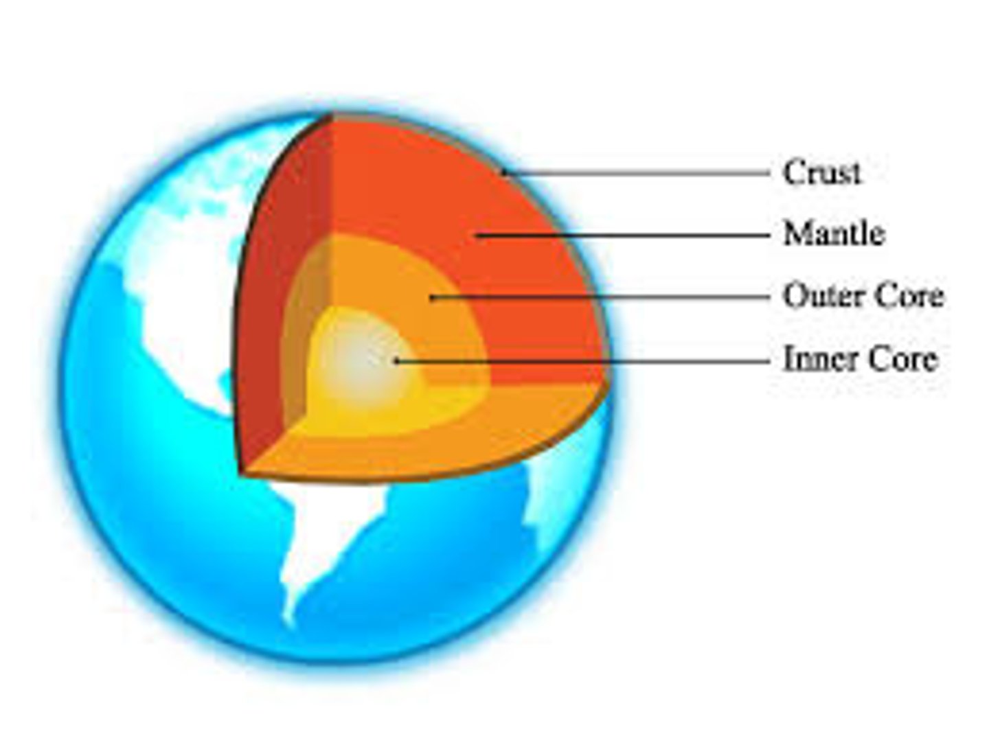
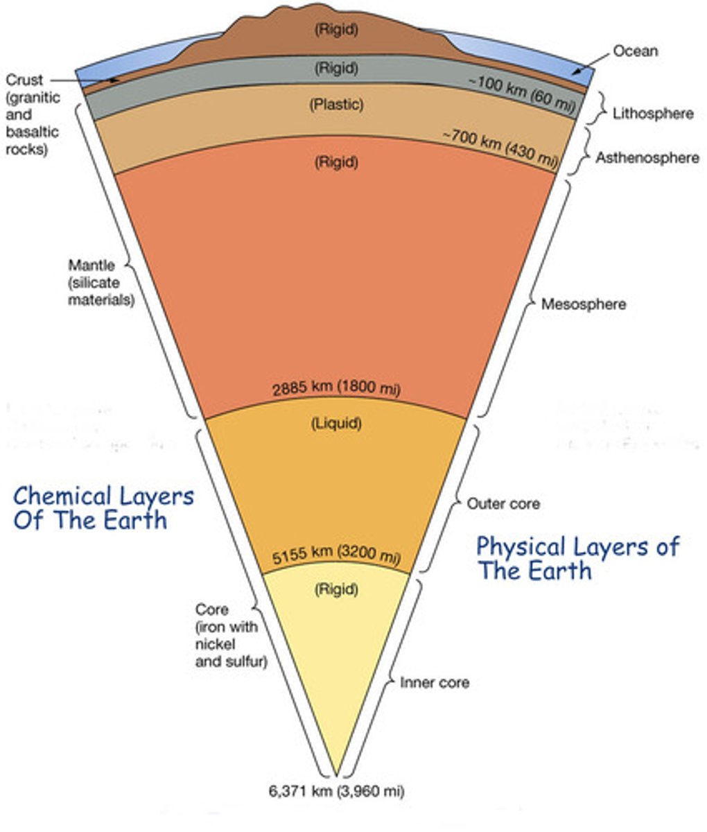
Layers of the Earth
Speed of sound in water: 1500 m/sec
Depth= 1/2(1500 m/sec*travel time) it can tell us how deep the ocean is a specific location
How does sonar work and what does it tell us about the ocean floor?
how sediment depth and clean floor age changes with distance form the mid ocean ridges
New crust forms at ridges- Seafloor spreading. Pushes old crust out and eventually gets "recycled"
How old is the oldest ocean crust, and how much of the rock recored is therefore missing on the ocean floor given the age of the Earth (4.56 billion years)?
Oldest oceanic crust is 200 million years old
What feature of the Earth do minerals line up with that allow us to infer polar wander curves?
the earths magnetic field
What does magnetic polarity look like across the mid-ocean ridges?
there is a continuous chain of colonies on the ocean floor. Discovered that the Earth's magnetic field has reversed its polarity.
Are earthquakes distributed randomly on the Earth's surface?
No they are distributed along plate boundaries for the most part
What are some of the modern sources of support for plate tectonics theory?
InSAR (Interferometric Synthetic Aperture Radar)
measures post-earthquake displacements
Can a single tectonic plate contain both oceanic and continental crust?
one plate can contain both kinds of crust
How do oceanic and continental crust differ?
Oceanic: DENSE (3.2 g/cm3); Tinner (7-10km); Rocks include basalt and gabbros; The older, the colder; Accommodates pressure by either overriding or subducting.
Continental: LESS DENSE (2.7 g/cm3); Thicker (25-70km); Rocks include granite; Accommodates pressure by building enormous mountain ranges, this WILL NOT subduct!
Given how we zone the Earth by chemistry and by strength, what portions of the Earth make up the tectonic plates?
3 different kinds of boundaries?
1. Convergent
2. Divergent
3. Transform
2 different kinds of crust
1. Oceanic
2. Continental
Convergent Boundaries
-2 plates move towards each other
-Makes the crust in the area SHORTER: where we recycle old crust (destructive)
Who subducts? Ocean-Content
Oceanic crust always subducts
Who subducts? Ocean-Ocean
Old Oceanic crust will subduct
Who subducts? Continent-Continent
Neither Subduct, the pile up to create mountains
Ocean-Continent Convergence: the Andes
Nazca Plate subducting under the South American Plate. Convergent Boundary
How Volcanoes form (three main ways)
1. Lithosphere descends deep into the mantle and heats up, generating melt
2. Lithosphere descends deep into the mantle and releases water, generating melt (a term for this is flux melting)
3. The lithosphere is pulled apart and the asthenosphere rises and melts (decompression melting)1
How mountains are formed
1. Colliding plates with each other
2. We subduct lithosphere, generating volcanic mountain ranges
How we get earthquakes
1. We slide plates past each other
2. We push plates into each other
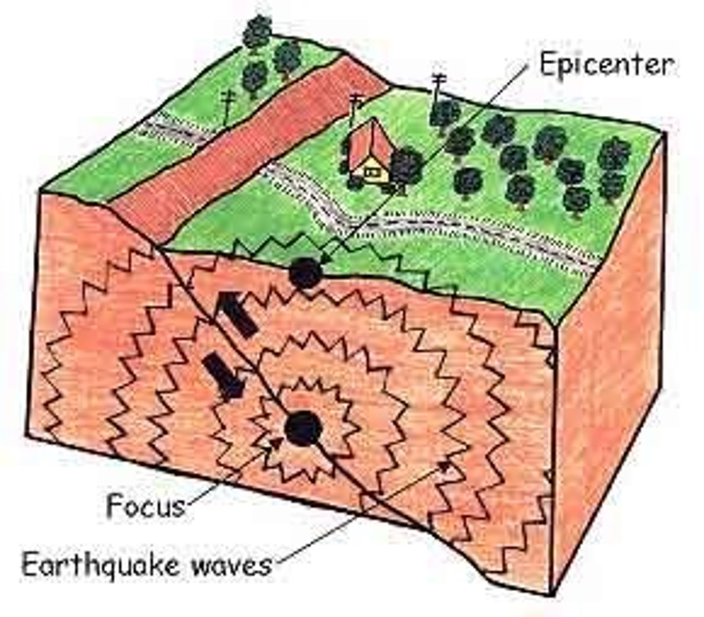
shaking of the ground caused by sudden motions along faults, or fractures in the earths crust
Wadati-Benioff zones
Where crust gets recycled: You can see the outline of the subducting plates, this is why we see such deep earthquakes: they occur in the subducting slab as it descends into the mantle.
Summary of Ocean-Continent convergence
-oceanic crust consumed
-earthquakes occur at great depths (up to 600 km!)
-Subduction zones are the only place on Earth we can get earthquakes at more than 100 km depth (Wadati-Benioff zones)
-Trench where plate goes down
-Huge mountains
-Volcanism
Ocean-Ocean convergence
Older colder plate subducts, deep ocean trenches, Wadati-Benioff zones of deep earthquakes deep ocean trenches and curveted island arc, volcanism
Continent-Continent Convergence
India and the Eurasian plates produce the Himalayas where they collide. Under Himalayas is some of the most thick crustal. Not many volcanos. extreme amount of earthquakes due to crust running into each other. Here, the crust is piled up, broken, and thirsted on top of itself. This is due to the extreme forces pushing these two tectonic plates together.
Divergent Boundaries
We make new crust, like mid Atlantic Ridge, African Rift Valley, plates pull away from each other.
African Rift Valley
we are making a new ocean basin, we see the development of horses and grabbers, these down dropped blocks result from the crust pulling apart as the rift widens. We get parallel faults (breaks in the ground surface) across the rift as well.
`Ocean divergence
best example is Mid Atlantic Ridge or East Pacific Rise. Crust pulls apart asthenosphere rises and melts, and we get new crust. Mid ocean ridges are massive underwater volcanic chains. Spreading rates vary from 1-20 cm/year.
Transform Boundaries
-plates slide past each other, conservative (crust is neither created nor destroyed)
-the Mid Ocean ridge is offset by transform boundaries. These link spreading sections of the ridge.
-Depth of earthquakes at oceanic transform boundaries is limited by transform faults.
-the San Andreas in California is a continental transform boundary.
San Andreas fault
large earthquakes every 150 years, different segments have behave in different ways. part of a very complex tectonic setting. Loma Pieta earthquake. Overall California is part of a very complex tectonic setting. cracks in the ground and earthquakes
conservative boundaries
crust is neither created nor destroyed, transform
destructive boundaries
crust is destroyed, convergent
creative boundaries
crust is created, divergent
What do hot spots tell us about, and what is a hot spot? examples???
crust moves over mantle plumes examples include, yellowstone and Hawaii.
Earthquake
Seismology is the study of earthquakes, and earthquakes is seismic release of energy from rocks that were locked. Cold, brittle rocks build up strain along fault planes until elastic strain in surrounding rocks overcomes frictional force, then release strain over a time period of seconds to minutes. This generates earthquakes.
Strain
the resulting deformation
Elastic strain
(what we see in the rocks bordering fault plains): this change in rock shape resulting from stress will be reversed when the fault plane slips (rocks will return to original shape)
What controls the global distribution of earthquakes (where do they occur)?
Mostly at plate boundaries, also at faults. Wadati-Benioff zones and other convergent boundaries: plates run into each other (compressional settings where we have reverse and thrust faults); Transform boundaries (like San Andreas) where plates slide past each other.
Earthquake Anatomy
Focus (hypocenter) point within the Earth's crust where energy is released from (x,y,z: latitude, longitude, and depth) KNOW DIAGRAM
Body waves
tell us about the interior structure of the Earth. Seismic wave velocity varies as the properties of the material that they are passing through changes (properties include density, elasticity, composition, pressure, and temperature). When waves pass from one material into a different material, they can be bent (redacted) and may also bounce off of it (reflected).
Body Wave: P-Waves
compressional (material is pushed): FASTEST. Deflected in interior of Earth when traveling through outer core
Body Wave: S-Waves
shear (material moves back and forth): SECOND FASTEST, cannot travel through liquid outer core.
Surface Waves
the most destructive waves produced by earthquakes: they can cause the worst ground shaking. travel the slowest of all seismic waves, and move along the surface of the Earth.
Types of Surface Waves
Rayleigh waves: vertical, these look like ocean waves
Love waves: horizontal, these slide back and forth
The Mohorovicic discontinuity
crust/mantle boundary, within lithosphere; change in velocity of seismic waves.
The Lehmann discontinuity
boundary between inner and outer core
What information do we use to locate earthquakes? What instrument do we use, and how many stations do we need?
It is possible to locate earthquakes because P and S waves have different travel times. We record their arrivals with instruments called seismographs, which produce seismograms (the recordings of ground motion). As distance from an earthquake increases, the distance in arrival time between P and S waves also increases. We can therefore look at seismograms and gauge distance from an earthquake's epicenter. three seismograms.
Richter scale
developed for earthquakes in California, performs poorly with very large earthquakes
Mercalli scale
we determine the size of historic events based on this, which uses reports of damage and what people felt
MW: Movement Magnitude
This is what most news outlets report. The Mw scale is based on the amount of slip that occurs and the length of the fault that slips. It is an estimation of energy released, and is a logarithmic scale: a 9 is 10 times more powerful than an 8 an 8,etc. Theoretically, there is no limit to how hight his scale could go (a Mw 16 would split the Earth in half) but we don't have any faults long enough to produce anything bigger than what we've seen.
Earthquake Hazards: Shaking
ground motion produced by surface waves. These are the destructive waves, and the force generated by them can knock buildings down, knock things off walls, etc.
Earthquake Hazards: liquefaction
unconsolidated sediment, when shaken by an earthquake, can liquefy - buildings on it will subside.
Earthquake Hazard: Tsunamis
generated by movement of the crust under the ocean, or by landslides. These can produce enormous and extremely devastating waves. Tsunamis are generated by movement of the entire ocean column and can travel at speeds exceeding 500 kmh and have extremely long wavelengths (100 km plus)
Earthquakes in the United States (New Madrid Fault Zone)
We do have record of big earthquakes in the United States, even in places that aren't California or Alaska. New Madrid Fault Zone, Historically Mw 7+, last major earthquakes in the 1800s. This zone may be building energy for another release. New York City frequently experiences EQ of magnitudes between 2-3 but historically has had a 6.
Earthquake forecasting
we look where faults are locked, and look at past events to estimate magnitudes and recurrence intervals. From this, we can estimate how likely an EQ might be in a certain time period.
Earthquake prediction
can't predict when a fault is actually going to slip.
what should you do if you feel an earthquake
get under a desk and hold on to it so it doesn't move
What do diamonds and pencil lead have in common
Carbon
1. Inorganic: not alive (or once living)
2. Naturally occurring: not manufactured.
3. Solid: firm and stable in shape
4. Characteristic chemical composition
5. Crystalline structure
What are the five requirements minerals have to meet to be classified as a mineral?
Why does a mineral differ from an element?
in minerals, the smallest unit that we can break down to is the UNIT CELL: this is where we see our orderly, repeating atomic structure. Elements can be broken down into one atom. There are native minerals that are composed of exclusively one element, such as gold and copper.
crystallize (mineral)
from magma or lava
precipitate (mineral)
out of water or other fluids
weathering reactions
minerals formed from weathering reactions.
Why are minerals environmental fingerprints?
Minerals are environmental fingerprints because they give us specific information about how and where they are formed (stability fields)
Protons
positive charge
Neutrons
no charge (neutral)
Electrons
negative charge (these form a cloud around the nucleus)
Atomic number
number of protons
Mass number
number of protons + neutrons
Isotopes
Atoms of a particular element that have different numbers of neutrons. they can be stable or unstable (unstable isotopes decay and can be used to estimate ages) and exam is uranium
Covalent Bond
share electrons and strongest
Ionic
take electrons, Ionic solid: electrostatic attraction between positive cations and negative anions. Ordered arrangement of oppositely charged ions but maintains overall electric neutrality
Mineral properties: Color
not always diagnostic- can vary due to different trace elements (example: red corundum is ruby; any other color of corundum is a sapphire)
Mineral properties: Clarity
a. Transpatent: see through
b. Translucent: foggy
c. Opaque: impervious to light (like metals)
Mineral proporties: Crystal Form (habit)
how a mineral grows when there is nothing inhibiting it. This reflects the internal crystal lattice structure, and different minerals may have characteristic crystal shapes.
Mineral properties: Luster
how light reflects from the surface of an object, two classes
a. Metallic (like metal)
b. Non-metallic (does NOT look like metal)
Mineral properties: Streak
Color of the mineral in powdered form.
Mineral properties: Hardness
use Moh's hardness scale
Mineral properties: Cleavage
tendency of some minerals to break along flat, parallel surfaces (cleavage planes) that are weak planes within the crystal. described by the geometric shape formed: the number of planes and the angles between them (as well as how good they are - are they shinny?)
Fractures
breaks that do not occur along cleavage planes. these look like broken glass, and can occur because bond strength is EQUAL in all directions.
how do Igneous rocks form?
cooled from molten material (hot material at the Earth's surface-these are extrusive)
how do Sedimentary rocks form?
aggregates of smaller grains
how do Metamorphic rocks form?
a sedimentary or igneous rock that has undergone high temperature or pressure but has NOT melted all the way
magna when gets to the earth is called lava. hot material at the Earth's surface is extrusive, and below the earth is intrusively.
What is the difference between magma and lava?
What determines our final type of igneous rock?
a. type of material that was melted (source), and addition/deletion of different components
b. way the material solidified (rate of cooling, related to whether rock is intrusive vs. extrusive)
Mafic minerals
dark in color and include pyroxene, olivine, amphibole, and biotite mica
Felsic minerals
lighter in color and include quartz, potassium feldspar, muscovite, and Narich plagioclase feldspar.
Oceanic crust: Mafic, dense, thinner
Continental crust: Felsic, Less Dense, thicker
Oceanic vs Continental Crust
What are our three different ways of generating melt and what plate tectonic settings are they associated with?
1. Add Heat (thermal melting) where plates run into each other, we can push one down to great depths, where it will heat up and melt.
2. Decrease pressure (decompression melting) where plates pull apart from each other, we can move solid mantle material into a lowe pressure environment (it moves upwards) and melt it by decompression.
3. Add Water (fluid-induced or 'flux' melting). Where we take plates and run them into each other, we can also force water-rich minerals down into the Earth. Water lowers the melting point of rocks, so this can generate flux melting.
Different minerals will form as temperature drops because they will be stable (i.e. olivine forms first)
What is fractional crystallization and how does it affect the rock that we might form?