Lecture 9&10 ENSO: From climate to fish and beyond
1/29
There's no tags or description
Looks like no tags are added yet.
Name | Mastery | Learn | Test | Matching | Spaced | Call with Kai |
|---|
No analytics yet
Send a link to your students to track their progress
30 Terms
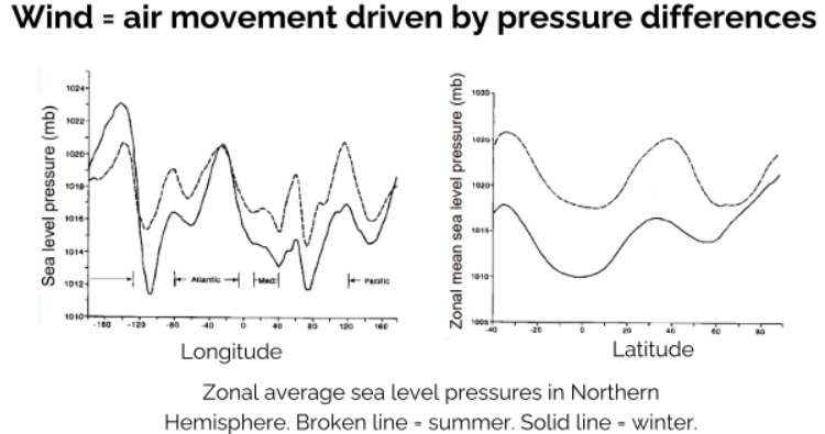
How does surface pressure vary?
Between longitude (E→W) and latitude (N→S)
Seasonally
Large spatial variation
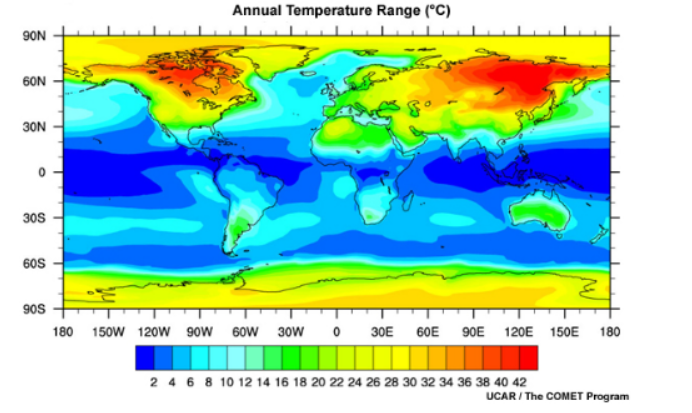
Which has a more stable temperature range, sea or land?
Sea - the high heat capacity of water buffers temperature fluctuations (thermal damping effect)
Heat capacity
Amount of heat energy that can be absorbed by something before it changes temperature/volume
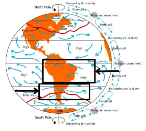
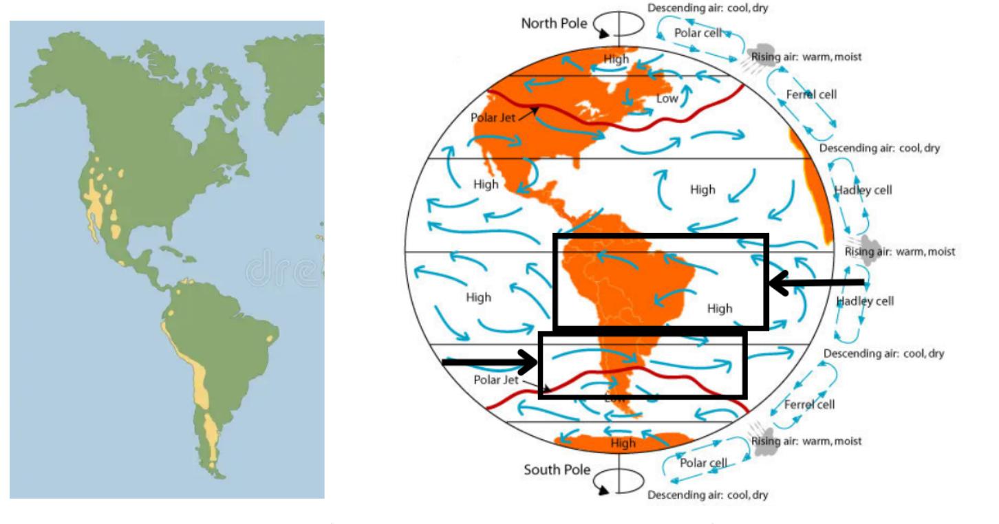
How do climate zones come about?
Different high and low pressure - heat and water
How does the location deserts come about?
Prevailing wind patterns
How do the prevailing winds lead to deserts?
Air picks up moisture as it goes along
Driven because it’s falling from its atmospheric cell and moved in a circular pattern (Coriolis effect)
Wind is moved from East to West (can vary)
Deposits moisture on one side of the continent
By the time the air reaches the other side of the continent, it is much drier
Forming deserts
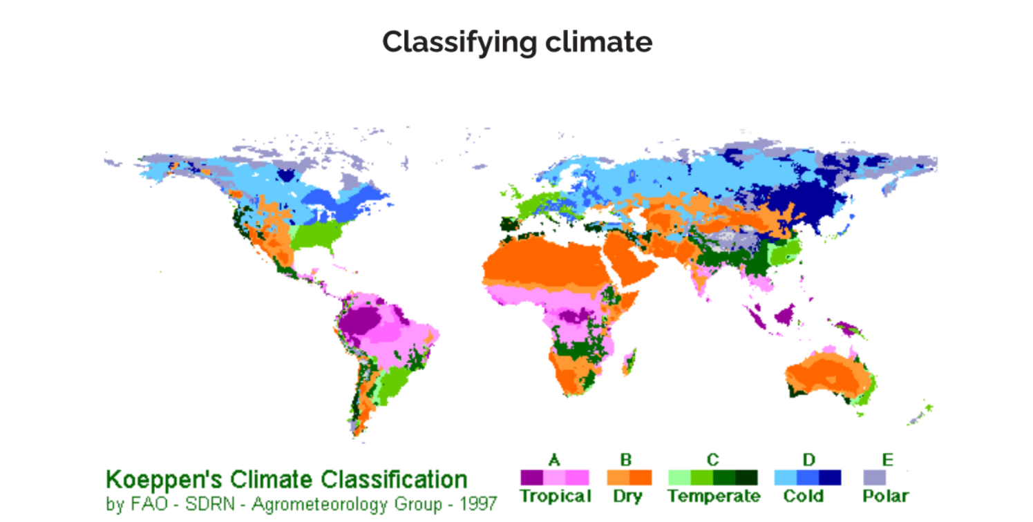
How do you identify climate zones?
Precipitation patterns
Temperature range
Prevailing winds
How do you classify the climate?
Moisture
High/Low pressure
Organisms/vegetation surviving
What is Koeppen’s Climate Classification?
Divides the climate into 5 main groups: Tropical, dry, temperate, cold and polar
Then subdivides them into divisions for each group
What disrupts coastal upwelling systems?
El Nino
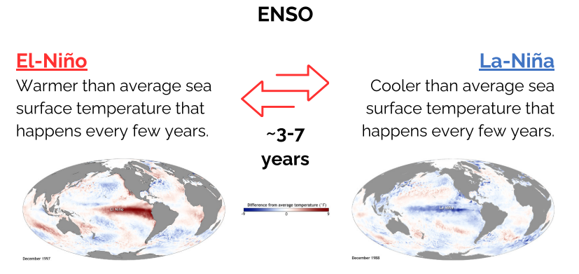
What is El Niño?
Changes in the surface ocean temperature in the Pacific Ocean
What is the Southern Oscillation?
Changes in atmospheric pressure that occur between East and West in the Pacific Ocean
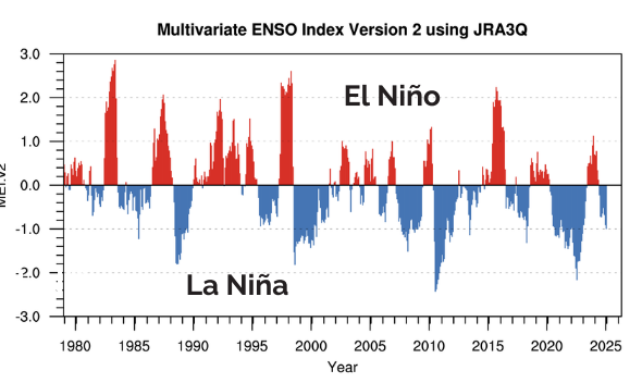
How is El Nino and Southern Oscillation linked (ENSO)?
ENSO: Changes in atmospheric pressure and wind patterns drive El-Niño and La Niña
What are the two parts to ENSO?
El Niño: Warmer than average sea surface temperature that happens every few years
La-Niña: Cooler than average sea surface temperature that happens every few years
~ 3-7 year cycle
Neutral periods in between
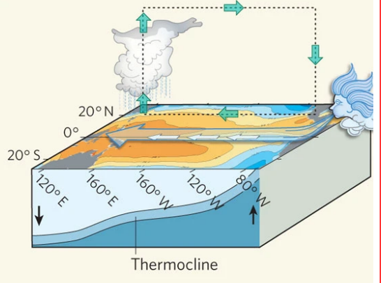
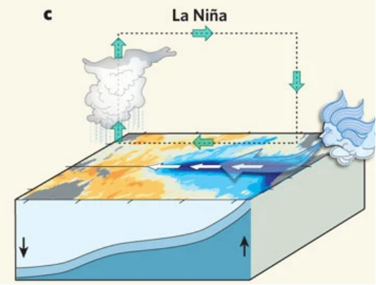
What is the ‘average’ system in the Pacific (neutral)?
Trade winds (East to West) across the Pacific
Air and surface water warmer at the equator - pushed West and bunches up
Upwelling of cold, nutrient-rich water in the East
Thermocline develops - water at depth moves from West to East (warmer → cooler)
Warm, moist air rises in the West - lower pressure area
Air cools and falls in the East, giving cool, clear conditions - higher pressure area
Productive Eastern waters
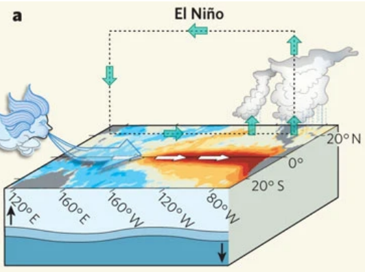
What are El Niño conditions?
Prevailing winds become West → East (reversed)
Opposite to ‘normal’ conditions occur
Warm, moist air rises in the East
Air cools and falls in the West, giving cool, clear conditions
What are La Nina conditions?
East → West trade winds become stronger
‘Normal’ is amplified
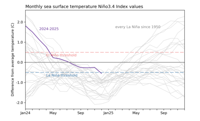
What is the ENSO Index?
Quantifies El Nino and La Nina
Unitless number, describing the deviation of the climate from ‘normal’
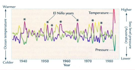
Changes in sea surface temperature correspond to what?
Changes in sea surface level atmospheric pressure
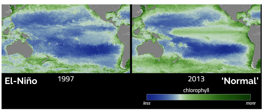
How does El Nino affect primary production?
Less primary production (chlorophyll) during El-Nino compared to ‘normal’
During El Nino = fewer nutrients for the food web
More chlorophyll = more phytoplankton = more productivity/nutrients
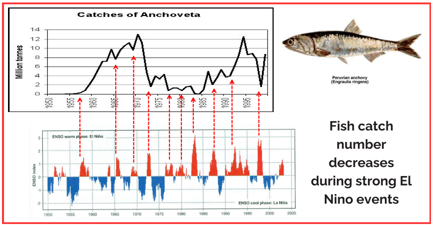
What happens to the fish catch numbers of Anchovey during El Nino?
Decreases
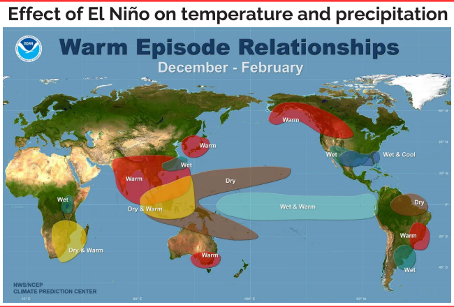
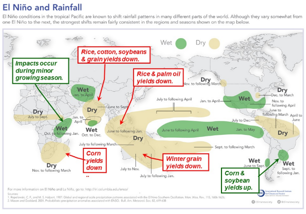
Where do ENSO events affect?
Many parts of the world
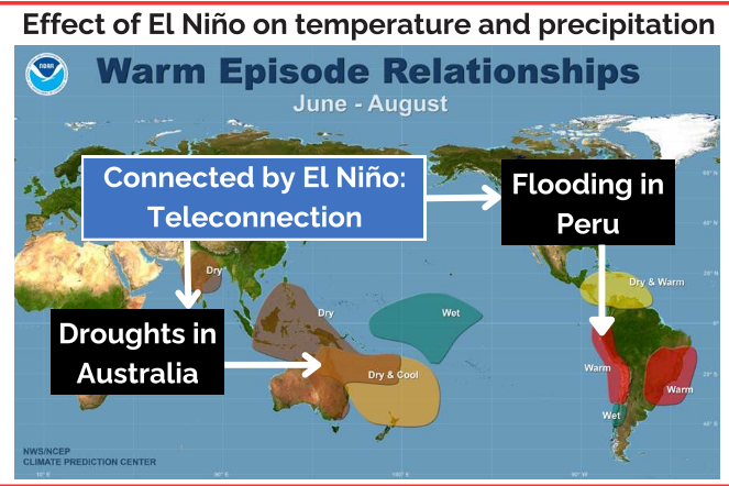
What is the Teleconnection?
Significant relationships linking weather phenomena across far-apart areas of the globe, e.g. Droughts in Australia with Flooding in Peru, connected by El Niño
How does ENSO affect places further abroad?
Interacts with jet streams
Changes in Pacific temperature and precipitation (pressure) affect the location and paths of the atmospheric jet streams
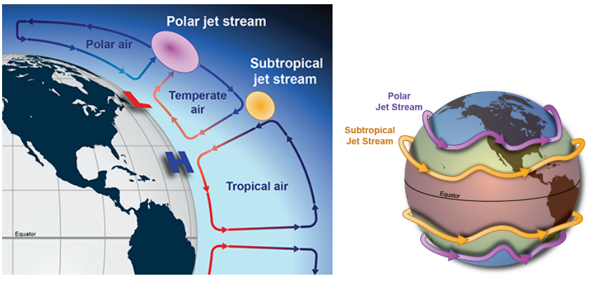
What are the jet streams?
In between cells, very strong wind
Strong ribbons of air around the world
Subtropical forms: between hadley and ferrel cells, relatively warm
Polar: forms between polar and ferrel cells, cooler
What happens to the jet stream during El Niño?
Subtropical: More amplified and straighter, takes a more direct path across the United States
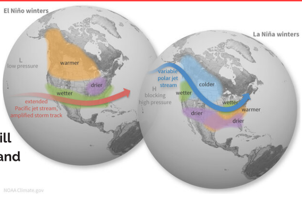
What happens to the jet stream during La Niña?
Polar: Comes further south, bringing wetter/colder weather

How does El Nino effect coastal populations?
Causes major flooding
Impacts crop growth (agriculture)
How is ENSO forecasted?
Monitoring Sea Surface Temperatures