GENSCI - LESSON 4 (only main ifn)
 Call Kai
 Learn
Learn Practice Test
 Spaced Repetition
 Match
Match Flashcards
 Knowt Play
1/43

Earn XP
Description and Tags
GEOLOGIC PROCESES AND HYDROMETEOROLOGICAL PROCESSES THAT SHAPE THE PHILIPPINES
Name | Mastery | Learn | Test | Matching | Spaced | Call with Kai |
|---|
No analytics yet
Send a link to your students to track their progress
44 Terms
1. Typhoon
2. Thunderstorms
3. Flood
4. Storm Surge
5. Landslides
Hydro-Meteorological Phenomena and Hazards:
1. Earthquake
2. Volcanic Eruptions
Geological Phenomena and Hazards:
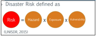
Hazard
Potential occurrence of a natural or human-induced physical event or trend or physical impact that may cause loss of life, injury, or other health/property impacts.
Vulnerability
Propensity or predisposition to be adversely affected.
Exposure
Presence of people, livelihood, species or ecosystems, etc
Risk
Potential for consequences where something of value is at stake and where the outcomes is uncertain, recognizing the diversity of values.
Disaster
When hazards interact with or impact humans and the built environment, disasters occur.
NOPE, NAH, NAURRR
ONLY NATURAL HAZARD
IS THERE SUCH THING AS A NATURAL DISASTER?
GEOLOGICAL HAZARDS: VOLCANIC ERUPTION
● Sudden eruption of molten rock (magma/lava), ash and gases onto Earth’s surface
● Pacific Ring of Fire
Philippine Sea Plate and the Eurasian plate
The Philippines sits on a unique tectonic setting ideal to volcanism and earthquake activity. It is situated at the boundaries of two tectonic plates – the ___ and ___ – both of which subduct or dive beneath the archipelago along the deep trenches along its east and west seaboard.
magma
Molten material (melted rock) inside the Earth
lava
Molten material (melted rock) erupted by a volcano; at the surface of the Earth
24 ; 300
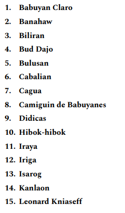
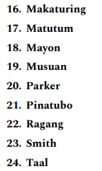
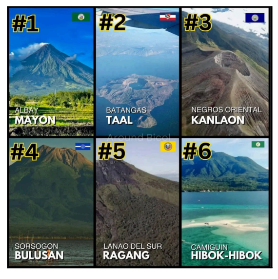
The Philippines boasts ___ active volcanoes among the ___ dormant ones, spread across its archipelago.
volcanic hazards
phenomena arising from volcanic activity that pose potential threat to people or property. Below is a list of volcanic hazards common in Philippine active volcanoes.
MT. PINATUBO ERUPTION (1991)
Heavy rainfall from Typhoon Yunya triggered destructive lahar flows around Mount Pinatubo
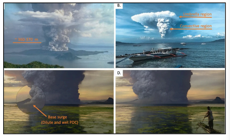
Taal eruption (2020)
Photographs and screenshots of videos of the 12 January 2020 eruption of Taal. (A) Eruption showing a lateral basal cloud with an estimated fountain height of 360-370 m. (B) Umbrella cloud and convective regions. (C) Magnified view of base surges (dilute and "wet" PDCs) forming In the southeast sector of TVI; (D) Dust covering the southeastern slopes of TVI.
Geological hazards: Earthquakes
● Sudden shaking of the ground caused by movement along fault lines or volcanic/magmatic activity
● Common in tectonic plate boundaries
● Caused by seismic waves (surface waves being the most destructive and dangerous)
Hypocenter or focus
point inside the earth where the earthquake started
epicenter
point on the surface of the earth directly above the focus
● Part of Pacific Belt/Ring of Fire
● Bounded by oppositely dipping subduction zones
★ East: East Philippine Trough -Philippine Trench
★ West: Manila-Negros-Sulu-Cotabato Trenches
● Presence of the 1,200 km-long left-lateral Philippine Fault Zone (cutting the Philippines from Mindanao to Luzon)
WHY DO EARTHQUAKES OCCUR IN THE PHILIPPINES? READ
Magnitude and intensity
There are two ways by which we can measure the strength of an earthquake:
magnitude
● Proportional to the energy released by an earthquake at the focus.
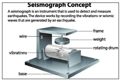
● Measured and recorded by a seismograph.
● Represented by Arabic Numbers (e.g. 4.8, 9.0).
Intensity
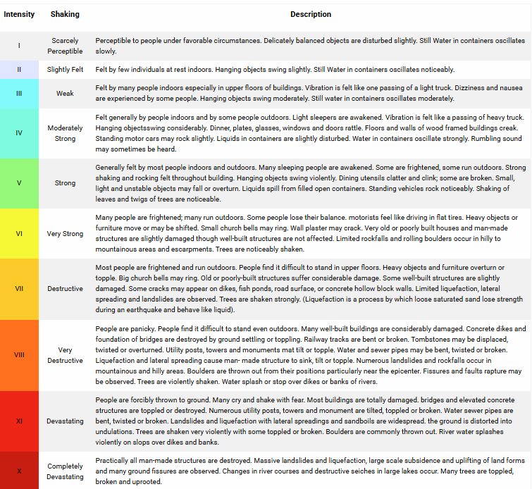
● The strength of an earthquake as perceived and felt by people in a certain locality (subjective).
● Has a numerical rating based on the relative effects to people, objects, environment, and structures in the surrounding (generally higher near the epicenter).
● Represented by Roman Numerals (e.g. II,IV,IX).
● In the Philippines, the intensity of an earthquake is determined using the PHIVOLCS Earthquake Intensity Scale (PEIS).
The PHIVOLCS National Earthquake Monitoring and Information
aims to provide accurate and timely information on significant earthquakes and tsunami events that may significantly impact the Philippines; and to ensure the accessibility and integrity of earthquake data. Earthquake monitoring in the country has been enhanced with the operation of ninety two (92) Seismic Network, ten (10) Seismic Stations of which were commissioned in 2016.
GEOLOGICAL HAZARDS: MASS WASTING/LANDSLIDES
● Mass movement of rock, soil, and debris down a slope due to gravity.
● Occurs when the driving force is greater than the resisting force.
● A natural process that occurs in steep slopes. The movement may range from very slow to rapid.
● Can affect areas both near and far from the source. ● Mass wasting/ landslide materials may include:
★ Soil
★ Debris
★ Rock
★ Garbage
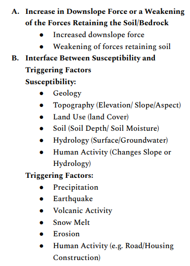
READ: WHAT ARE THE FACTORS CAUSING LANDSLIDES?
rotational landslide
Ground rotates and slides along a curved failure plane.
translational landslide
- Ground slides with little rotation along a flat plane parallel to the surface.
block slide
A type of translational landslide made of mostly one block of surface material that moves downslope.
rockfall
Gravity sends rocks and Other materials tumbling downslope.
topple
Pieces of a cliff or rock face fall forward as large blocks
earthflow
Form on moderate slopes when fine-grained material liquefies and runs out in hourglass shape
lateral spread
When surface material extends or spreads on gentle slopes. This type of ground deformation is often associated with earthquake shaking.
debris flow
Rapidly moving mix of water, mud, trees, and other materials that flows downvalley and can travel great distances.
debris avalanche
An extremely large and fast moving debris flow
creep
Soil and surface material that slowly moves down a slope.
Direct Impacts:
● Loss of Life
● Damage to Property
● Damage to Infrastructure
Indirect Impacts:
● Broader Economic Impacts
● Disrupted Provision of Services in a Larger Area
Sectors Impact:
● Transportation
● Housing
● Water
● Urban
● Agriculture
● Energy (Hydropower)
Impacts of Landslides
GEOLOGICAL HAZARDS: TSUNAMI
● Huge sea waves caused by undersea earthquakes or volcanic eruptions whose heights could be greater than 5 meters.
● Erroneously called tidal waves and sometimes mistakenly associated with storm surges.
● Can occur when the earthquake is shallow-seated and strong enough to displace parts of the seabed and disturb the mass of water over it.
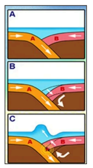
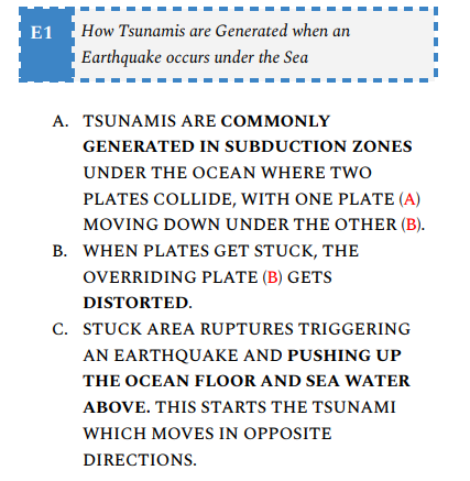
READ
SLOW-ONSET HAZARDS: EROSION
The process by which soil, and mineral and rock particles are worn away and moved elsewhere by gravity, or by a moving transport agent (wind, water, ice)
heavy rainfall
wind
soil erodibility
local climate and vegetation loss
natural causes of erosion
mining
deforestation
shifting agriculture
human causes of erosion
reduced crop production
silting up of reservoirs
eroded soil leading to floods
loss of humus (source of nutrients)
loss of livelihood
increasing deaths
economic loss
effects and risks of soil erosion
SLOW-ONSET HAZARDS: SALTWATER INTRUSION
● The process where seawater infiltrates freshwater aquifers, mixing with and potentially contaminating the freshwater supply.
● This phenomenon is common in coastal areas where freshwater aquifers are hydraulically connected to the ocean.
● Can also occur in inland areas due to human activities like groundwater extraction and construction