coasts
1/35
Earn XP
Description and Tags
Name | Mastery | Learn | Test | Matching | Spaced | Call with Kai |
|---|
No analytics yet
Send a link to your students to track their progress
36 Terms
Define a coast.
The zone where the land meets the sea.
What causes waves?
The friction of the wind on the surface of the water.
What three factors affect wave energy?
Wind speed (means higher energy waves)
How long the wind has been blowing (means higher energy waves)
The fetch (distance of open sea, increases possibility of bigger waves)
Define swash and backwash.
Swash - The surge of water up the beach when a wave breaks
Backwash - The returning of water and sediment back down the beach towards the sea
Describe a constructive wave.
Found in sheltered bays
Swash is stronger than backwash
Water spreads a long way up the beach
Little height and low energy (wave height under 1m)
Gentler beach profile
Long wavelength
Describe a destructive wave.
Found in more exposed bays
Swash is weaker than backwash
Builds headlands
Doesn’t travel far up the beach
Much height and high energy (wave crest over 1m)
Steeper beach profile
Short wavelength
What is the difference between slumping and sliding?
Slumping - Movement downwards
Sliding - Movement horizontally
Define weathering and give three examples.
The on-site breakdown of rocks:
Biological weathering (natural breakdown due to trees growing on side)
Chemical weathering (rainwater/salty seawater hitting the rock)
Freeze-thaw weathering (water freezes in a crack, putting pressure on the rock before melting again)
What is mass movement?
The downslope movement of soil and rock, usually triggered by rain.
What are the four examples of mass movement, and describe them.
Rockfall: Rapid + dangerous free-fall of rock from a cliff due to gravity. Water causes the cracks in the rock to expand. A slope forms where the rock falls.
Mudflow: Occurs on slopes over 10 degrees - occurs after heavy rain or volcanoes. Soil flows due to lack of vegetation over impermeable subsoils.
Landslides/Slumps: Occasional rapid movement of rock after periods of rainfall. Water saturates overlying rock, causing it to slide over soft rock (clay and limestone).
Soil Creep: Slow movement of soil on gentle slopes due to the way the soil expands/contracts in wet/dry periods.
What four factors affect rate of cliff erosion?
Fetch between cliff and land
Strong winds that blow for a long time creating destructive waves
Beaches reduce erosion
Soft rocks erode faster than hard rocks
Define longshore drift.
The transportation of sediment along a coastline.
Describe the process of LSD.
Waves approach the shoreline at an angle due to the direction of prevailing wind
As the waves break, the swash carries material up the beach
Deposition occurs
The backwash carries some material back down at 90 degrees
This repeats, causing a zig-zag movement up the beach
What is the difference between a discordant and a concordant coast?
A discordant coast has different rock types (hard & soft), while concordant coasts only have one. Headlands and bays form on discordant coasts.
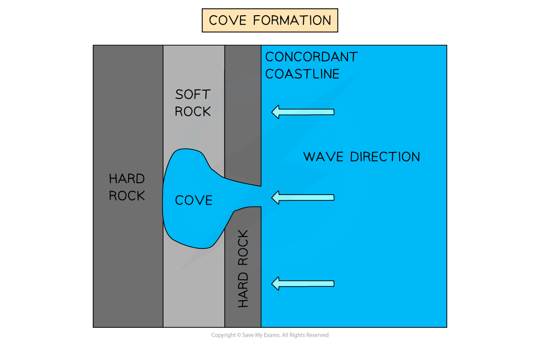
How does a cove form, and give an example.
Example: Lulworth Cove, UK
A point of weakness in hard rock is eroded at a slow rate via hydraulic action.
Soft rock erodes at a faster rate, so it expands.
How are bays and headlands formed?
They form along a discordant coastline [1]
Soft rocks (e.g clay or sandstone) erode faster than hard rocks (e.g. granite or limestone) [1]
Over time, the waves erode into the softer, less resistant rock along a discordant coast via a point of weakness [1]
The soft rock is eroded backwards and begins to form a sheltered bay [1]
Deposition takes place here due to low velocity of the water [1]
The headland (hard rock) is left, which has water on three sides and takes much longer to erode [1]
What is a wave-cut platform?
A flat part of land that extends from the base of a cliff out into the sea, formed on a hard-rock cliff face.
When do WCPs/WCNs form most commonly and why?
High tide - the waves are in contact with the cliff base.
Describe how a WCP forms.
Weathering weakens the rock and abrasion by shingles/hydraulic action weakens the base [1]
The rock breaks away and collects at the base of the cliff [1]
The cliff has a wave-cut notch [1]
The overhang is unsupported and falls onto the beach [1]
The cliff retreats backwards and increases in height [1]
The former base is a wave-cut platform which is continuously smoothed by shingle grinding over it. Algae can form over it. [1]
![<ul><li><p>Weathering weakens the rock and abrasion by shingles/hydraulic action weakens the base [1]</p></li><li><p>The rock breaks away and collects at the base of the cliff [1]</p></li><li><p>The cliff has a wave-cut notch [1]</p></li><li><p>The overhang is unsupported and falls onto the beach [1]</p></li><li><p>The cliff retreats backwards and increases in height [1]</p></li><li><p>The former base is a wave-cut platform which is continuously smoothed by shingle grinding over it. Algae can form over it. [1]</p></li></ul><p></p>](https://knowt-user-attachments.s3.amazonaws.com/60c82dc2-5e21-47ff-a709-2ff3e278b2b2.png)
How do caves, arches, stacks and slumps form?
A point of weakness (crack) is opened up by hydraulic action [1]
This grows overtime into a small cave [1]
The cave breaks through the headland and forms a natural unsupported arch, e.g. Durdle Door, Dorset [1]
The arch collapses, leaving a free-standing rock stack [1]
The stack erodes and forms a stump, which’ll eventually disappear. This can be seen at the Old Harry Rocks, Dorset [1]
All the above can influence cliff retreat [1]
What conditions cause a sandy beach to form?
Low energy constructive waves (stronger swash)
When the tide goes out, there is more smaller material on the beach than before
Sandy beaches have a gentler profile
What conditions cause a pebble beach to form?
Large fetch
High energy destructive waves (weaker swash)
Heavier sediment (pebbles) aren’t moved that far up the beach
Pebble beaches have a steeper profile
Describe a beach profile from inland to offshore.
Sand dunes or storm beaches
Backshore (not affected by waves so usually dry)
Foreshore (repeatedly covered and uncovered by changing tides)
Near-shore (where waves break)
Offshore
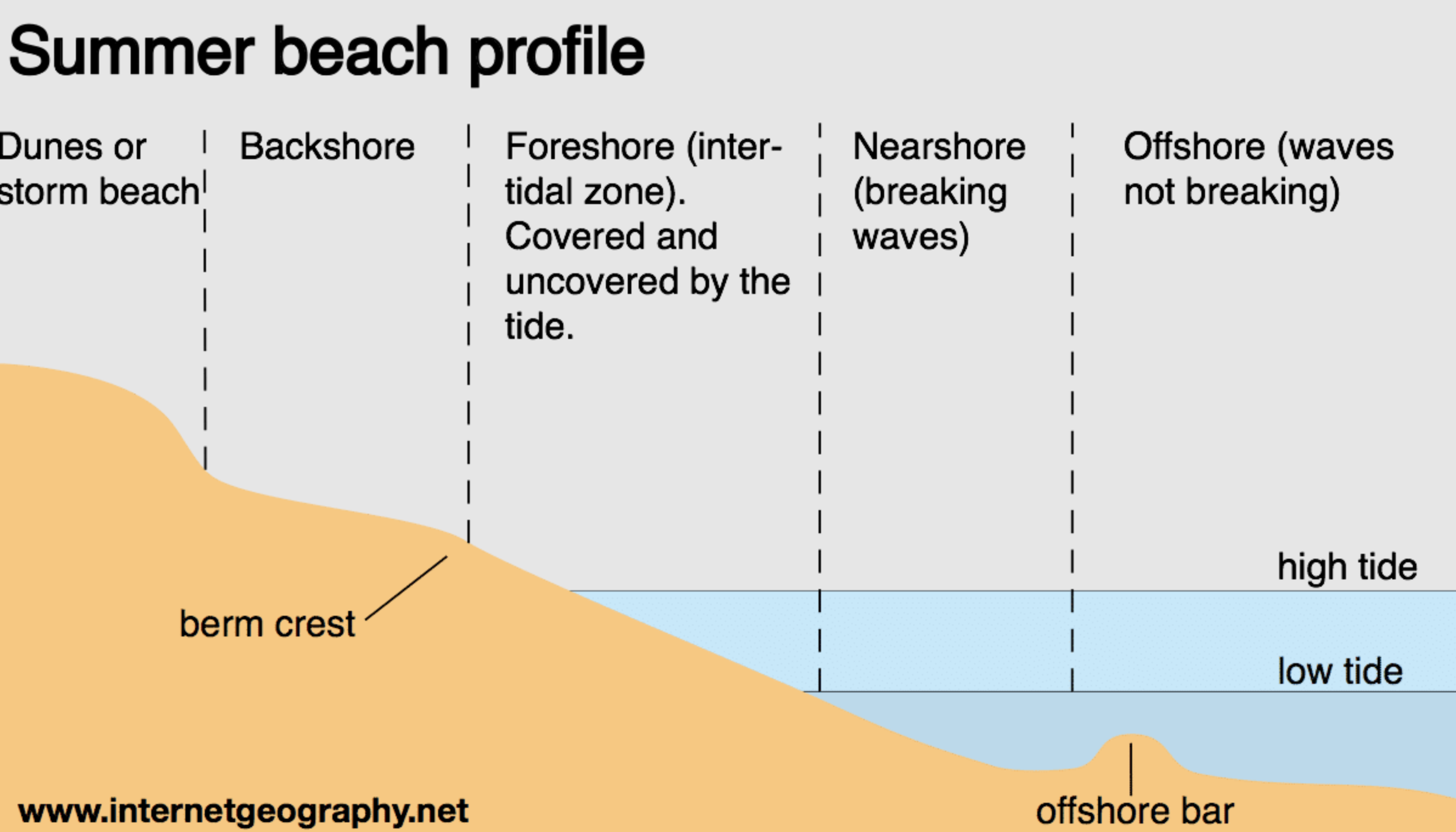
Define a berm.
A sloping ridge of material deposited by waves, found on the back shore. The peak of the berm is the berm crest.
Define a sand-dune and how do they form?
A hill/ridge of sand accumulated by the wind and water.
An obstacle blocks the sand from being picked up
Height builds up, forming a sand-dune (the slope will be steeper on the leeward side
The roots of marram grass binds the sand together
Dunes further away from the beach may be duller in colour, and more vegetation will grow
Blowouts form between the dunes when the wind changes direction
Define a spit/bar.
A narrow ridge of sand or shingle
How do spits and bars form?
Erosion takes place on cliffs e.g. hydraulic action, and sediment is transported along the coastline via longshore drift.
The prevailing wind controls the direction of the wind and therefore LSD.
The LSD reaches a headland with a river, and deposition takes place due to loss of energy.
A spit is formed, and secondary wind caused by storms or seasons make the waves change direction, forming a hook.
A salt marsh forms because the sediment is trapped behind the spit, and the water is calm & shallow.
The spit doesn’t reach the other headland because the river’s flow provides energy to transport the sediment away. If there was no river, the spit would become a bar.
How do lagoons form?
A lagoon forms behind a bar in the old bay
What are offshore bars and when are they seen?
A submerged ridge of sand/shingle, which is seen at low tide running parallel to the shore.
What is managed retreat/coastal realignment?
Creating a new intertidal area inland offering a sustainable long-term solution to the prospect of raising sea levels.
What are some pros and cons of managed retreat?
Pros: Takes the pressure off of areas further down the coast, conserves the natural environment.
Cons: Can cause relocation of people and communities, high short-term costs for relocation, loss of agricultural land.
Case Study: Where in the UK can we see managed retreat taking place?
Medmerry, West Sussex Coast:
Why was it needed: Storms threaten to breach the beach, 300 homes and main road could be flooded, and yearly beach reprofiling at £200k was becoming unsustainable.
What was done: A 7km flood bank was created out of impermeable clay, funded by the EA.
Advantages: Prevents flooding of infrastructure(S), creation of footpaths from maintenance access tracks (S), creates fresh-water habitats (EN), and growth of local tourism e.g. bird watchers(E).
Disadvantages: Distress of people who were relocated (S), previous habitats e..g badgers would’ve been disturbed (EN), and total cost of £28M (E).
Summarise the four soft management techniques.
Beach nourishment - The moving of sediment to a beach losing sand.
Beach reprofiling - The re-shaping of a beach using existing material, due to lowering in winter by destructive waves.
Sand dune regeneration - The artificial creation of new sand dunes.
Managed retreat - Creating an inland intertidal zone where water can flow through.
Summarise the four hard management techniques.
Sea walls - A barrier along the back of a beach that reflects wave back to the sea.
Groynes - Wooden walls built perpendicular to the beach, trapping sediment transported by LSD (e.g. at Mappleton, Holderness)
Rock armour - Boulders made of hard rock that absorb high-energy waves (e.g. at Mappleton, Holderness)
Gabions - Wire cages filled with rocks that dissipate wave energy and reduces risks of landslides.
Case Study: Where in the UK can we see coastal management? Summarise.
Holderness Coast, NE England:
Physical features: Stacks, arches, and WCPs and Flamborough Head in the North; Spit at Spurn Head in the South; River Humber; long beaches along the coastline.
Why needed: Cliff made up of very soft boulder clay, high fetch from the E, and many villages have been lost.
Strategies: Construction of groynes/rock armour in Mappleton at a cost of £2m; 4.5km sea wall at Bridlington which creates a promenade; protection of gas terminal with rock armour.
Juicy Facts: Fastest eroding coast in Europe, and up to 4m of land can be lost during one storm.
Case Study: Discuss the pros and cons of coastal management with an example.
Example: Holderness Coast
Pros:
Very effective at reducing erosion
Beaches are becoming wider
Tourism has grown in Bridlington & Mappleton due to promenade
Cons:
Expensive
Can make the beach less accessible
Hard management strategies are quite unattractive
Rising of conflicts between farmers - only high-value land is being protected