coasts
1/86
There's no tags or description
Looks like no tags are added yet.
Name | Mastery | Learn | Test | Matching | Spaced | Call with Kai |
|---|
No analytics yet
Send a link to your students to track their progress
87 Terms
what is eustatic change?
a global change in sea level resulting from an actual fall or rise in the level of the sea itself
what is isostatic change?
local changes in sea level resulting from the land rising or falling relative to the sea.
caused by the weight of ice pushing earth’s crust down, when it melts the ground begins to rise again.
what are tectonic changes?
land being shifted up or down due to plate movements.
is tectonic uplift or downthrust short medium or long term?
short
is isostatic change short medium or long term?
medium
is continental separation and collision short medium or long term?
long
is thermal expansion short medium or long term?
short
is global warming and ice melting short medium or long term?
medium
what is isostatic readjustment?
the slow uplift of land after the immense weight of ice sheets from an ice age melts, causing the crust to rise from the mantle’s depression. this can create emergent landforms.
what impact has isostatic adjustment had on the coastline of the uk?
the north of england is rising as the ice sheets that once covered the ground have melted, causing the ground to rebound and rise. this also causes the south of uk to begin to sink.
what has happened to sea levels since the last ice age 10,000 years ago?
sea levels have dramatically increased since the last ice age as the glacial ice has melted, flooding the land and resulting in a eustatic sea level rise.
what implication does the potential melting of the Antarctica ice have on future sea levels?
it poses a massive threat to future sea levels as the entire continent holds enough ice to rise sea levels by over 58 metres if it melted completely. although this is unlikely, even the partial collapse of glaciers such as the thwaites glacier could add several metres to the sea level. this could potentially displace many coastal cities.
what is thermal expansion and what impact does it have on sea level?
as heat from the green house effect is absorbed, ocean temperatures rise and water expands. this is because the water molecules spread out which increases it’s volume and density. this contributes to sea level rise and may cause coastal flooding.
give an example of changes in relative sea and land with tectonic activity
2004 boxing day tsnuami sumatra
cause significant vertical movement of the crust which caused parts of the coastline to drop
areas of land which were above sea level were permanently flooded forming a submerged coastline, leaving a ria.
what is a ria?
former river valley drowned by rising sea levels
created by rising sea levels drowning river valleys
the floodplain of a river will vanish beneath the rising waters, but on the edges of the uplands only the middle and upper course valleys will be filled with sea water
leaves higher land dry leaving a ria
example: kingsbury estuary on south devon coast is a 6m long ria
what is a fjord? how is it formed?
drowned glacial valleys- a section of a glacially eroded valley flooded by the sea
typically found on coasts of norway, south western new zealand + greenland
they have steep valley sides and are fairly straight and narrow
typical u shaped cross section
formed when the sea drowned the lower part of glacial valleys that were cut to a much lower sea level
example: sognefjord noway
what is a dalmation coast? how is it formed?
long narrow islands running parallel to the coastline and seperated from the coast by narrow sea channels called sounds
they are produced by sea level rise flooding the coastline with the geological structure of folds aligned parallel to the coast
example: dalmation region of croatia has a limestone coastline stretching 520km nw-se
what are raised beaches? how are they formed?
Raised beaches are ancient shorelines, featuring wave-cut platforms and beaches, now located above current sea level, formed primarily by the rebound of land after ice ages (isostatic uplift) as ice sheets melted, lifting the crust faster than sea levels rose (eustatic rise)
what are relict cliffs? how are they formed?
Relict cliffs are steep slopes, often with features like old caves, arches, and wave-cut notches, that were formed by marine erosion when sea levels were higher but are now abandoned inland, sitting above the present-day high tide mark. They form when sea levels fall (due to ice melting or land uplift) after a period of active coastal erosion, leaving these fossilized features exposed on emerged land, known as raised beaches.
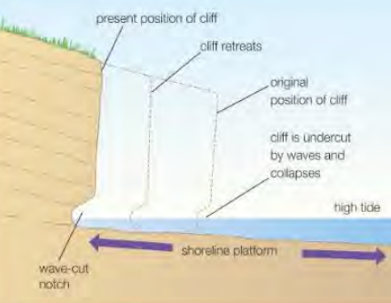
what is a marine platform? how is it formed?
A marine platform (or wave-cut platform) is a flat, gently sloping rock surface at the base of a cliff, formed by coastal erosion, where waves attack the cliff, undercutting it to create a notch, causing collapse and retreat, leaving the platform exposed at low tide. These platforms are formed through repeated wave action (hydraulic action, abrasion) undercutting the cliff base, which eventually collapses, leaving a smooth, wide ledge as the cliff retreats landward over time.
What 2 ways are there in which the volume of the oceans is increasing?
thermal expansion
melting ice sheets and glaciers
Why is sea level change prediction so difficult? what is the range in predictions?
uncertainties in future greenhouse emissions
complex climate system responses
model limitations
from 0.6 m to 1.9 m by 2100
what are the aims of coastal management?
to provide defence against and mitigate the impact of flooding
to provide protection against and mitigate the impacts of coastal erosion
what are groynes?
wooden structures placed at right angles to coast where LSD occurs
they reduce movement of material along coastline and hold the beach in place
causes material down the coast to be missing
example: groynes in withernsea
what are sea walls?
thick concrete or rock encasements of shore front. they may have a recurved top to assist deflection of waves back to sea
they are effective
long lasting- 20-30 years
protects settlements from floods
they are expensive to construct
maintenance is needed to prevent undercutting and fracturing beneath foundation
example: sea wall in hornsea
what are gabions?
steel mesh cages containing boulders of rubble and covered with plates with steel or concrete
implemented swiftly
more effective than sea walls
absorbs energy and reduces erosion
relatively cheap
looks ugly
high maintenance
houses rodents
deteriorate over time
what is hard engineering?
making a physical change to the coastal landscape using resistant materials, like concrete, boulders, wood and metal
What is soft engineering?
using natural systems for coastal defence, such as beaches, dunes and salt marshes, which can absorb and adjust to wave and tide energy
what are revetments?
steel cages containing boulders of rubble and covered with plates of stone or concrete
more effective than steel walls
implemented swiftly
ugly
may reduce beach access
requires regular maintenance and repair
what is rock armour?
large boulders piled on beaches where erosion is likely
cheap
absorbs wave energy
long lasting
little maintenance
natural looking kind of
can restrict shore line access
may be hazardous to people climbing on them
high transport costs
what is cliff fixing?
driving iron bars into cliff face
stops slumping
stabilises cliff and absorbs some wave power
what are offshore break waters?
man made islands, bars or reeds just offshore to cause waves to break
least “hard” method- it’s relocating a natural process
islands may form habitats
might need regular replenishment if material is eroded swiftly
construction material may contaminate water
what is a barrage?
large structures built to prevent flooding on major estuaries
acts as a dam and prevents incursion of seawater
large scale = expensive
example: Thames Barrier
What are the main advantages and disadvantages of hard engineering?
advantages:
long lasting
effective over planned lifespan
disadvantages:
structures can be expensive to build and maintain
defence in one place can have consequences for another area of the coast
structures are often an eyesore, spoiling the landscape and physically disrupting natural habitats
what is beach nourishment?
the addition of sand or pebbles to an existing beach to make it higher or wider
sediment is usually dredged from nearby sea bed
relatively cheap and easy to maintain
looks natural and blends in with existing beach = increases tourist potential
needs constant maintenance because of LSD and erosion
What is cliff regrading and drainage?
reducing gradient of slope to help stabilise it
drainage removes water to prevent landslides and slumping
can be effective on clay or loose rock where other methods will not work
drainage is cost effective
regrading effectively causes cliff to retreat
drained cliffs can dry out and lead to collapse
What is dune stabilisation?
marram grass can be planted to stabilise dunes
areas fenced in to keep people off newly planted dunes
maintains a natural coastal environment
provides important wildlife habitats
relatively cheap and sustainable
time consuming to plant marram
people may respond negatively to being kept off certain areas
what is marsh creation?
a form of managed retreat, by allowing low-lying coastal areas to be flooded by the sea
relatively cheap
creates natural buffer to powerful waves
creates important wildlife habitat
agricultural land is lost
farmers and landowners need to be compensated
What is cost benefit analysis and why is it used?
carried out before a coastal management project is given the go-ahead. costs are forecast and then compared with the expected benefits .
What is meant by tangible and intangible costs and benefits?
tangible- where costs and benefits are known and can be given a monetary value
intangible- where costs can be difficult to assess but are important (e.g visual impact of a revetment)
what coastal management has been used in holderness?
Bridlington is protected by a 4.7 km long sea wall.
Hornsea is protected by a sea wall, groynes and rock armour.
Coastal management at Withernsea has tried to make the beach wider by using groynes, and also uses a seawall to protect the coast.
Mappleton is protected by rock groynes.
Spurn Head is protected with groynes and rock armour.
why does holderness need coastal management?
coastline is rapidly eroding at 1.8 metres a year
cliffs are made up of a less resistant boulder clay that slumps when wet
naturally narrow beaches give less protection to beaches as it doesn’t reduce power of waves
powerful waves: waves travel long distances along north sea (long fetch) which means they will increase in energy
What was the medmery managed realignment scheme?
high tides threatened to breach single beach, 300 homes were at risk
water treatment works and a main road needed protecting
constructed an inland flood bank that’s 7km long
15 year project
60,000 tonnes of rock from norway imported to consolidate the flood defences
what is dynamic equilibrium?
the maintenance of balance in a natural system, despite it being in a constant change of state
what is weathering?
the breakdown of rocks over time, leading to the transfer of material into the littoral zone, where it becomes input to sediment cells
what are the three types of mechanical weathering?
freeze thaw
salt crystallisation
wetting and drying
what is freeze thaw weathering
water enters cracks in rocks and the water freezes overnight during the winter
as it freezes water expands by around 10% in volume which increases the pressure acting on a rock, causing cracks to develop
over time the cracks grow, weakening the cliff making it more vulnerable to other processes of erosion
what is salt crystallisation
as sea water evaporates, salt is left behind
salt crystals will grow over time, exerting pressure on the rock, which forces the cracks to widen
what is wetting and drying
rocks such as clay expand when wet and then contact again when they are drying
frequent cycles of wetting and drying at the coast can cause these rocks and cliffs to break up
what are the different types of chemical weathering
carbonation
oxidation
solution
what is carbonation
rainwater absorbs co2 from the air to create a weak carbonic acid which then reacts with calcium carbonate in rocks to form calcium bicarbonate, which can be easily dissolved
acid rain reacts with limestone to form calcium bicarbonate, which can also be easily dissolved allowing erosion
what is oxidation
when minerals become exposed to the air through cracks and fissures, the mineral will become oxidised which will increase it’s volume (contributing to mechanical weathering) causing the rock to crumble
most common oxidation within rocks is iron minerals becoming iron oxide, turning the rock rusty orange after being exposed to the air
what is solution (weathering)
when rock minerals such as rock salt are dissolved
what are the types of biological weathering
plant roots- roots of plants grow into cracks of rocks, which exerts pressure eventually splitting the rocks
birds- some birds such as puiffins dig burrows into cliffs weakening them making erosion more likely
rock boring- many species of clam secrete chemicals that dissolve rocks
seaweed acids- some seaweeds contain pockets of sulphuric acid, which can dissolve rock’s minerals
decaying vegetation- water that flows through decaying vegetation and then over coastal areas will be acidic, causing chemical weathering
what is mass movement
movement of material down a slope under the influence of gravity.
can be categorised into four main areas: creeps, flows, slides and falls
what is the type of mass movement dependent on?
cliff/slope angle
rock type
rock structure
vegetation
saturation of ground
presence of weathering
what is soil creep
the slowest but most continuous form of mass movement involving the movement of soil particles downhill
particles rise and fall due to wetting and freezing and this causes the soil to move down the slope
what is solifluction
occurs mainly in tundra areas where land is frozen
as the top layers thaw during summer (lower layers still stay frozen due to permafrost) the surface layers flow over the frozen layers
what are mudflows
increase in the water content of soil can reduce friction, leading to earth and mud to flow over underlying bedrock, or slippery materials such as clay
water can get trapped within the rock increasing pore water pressure, which forces rock particles apart and therefore weakens the slope
pore water pressure is an important energy source for determining slope stability and refers to the pressure of groundwater held within soil or rock
mudflows represent a serious threat to life as they can be very fast flowing
what is rockfall
occurs on sloped cliffs (0ver 40°) when exposed to mechanical weathering, though mostly occurs on vertical cliff faces and can be triggered by earthquakes
leads to scree (rock fragments) building up at the base of the slope
what are landslides
heavy rainfall leads to water between joints and bedding planes in cliffs (which are parallel to the cliff face) which can reduce friction and lead to a landslide
occurs when a block of intact rock moves down the cliff face very quickly along a flat slope
can be dangerous
how is a wave cut notch/ platform formed
erosion attacks the base of the cliff, creating a notch of eroded material between high tide height and low tide height
as notch becomes deeper (and sub-ariel weathering weakens cliff from top) the cliff face becomes unstable and falls under its own weight through mass movement
this leaves behind a platform of the unaffected cliff base beneath the wave- cut notch
how are caves, arches, stacks and stumps formed ?
sequence appears on pinnacle headlands
marine erosion widens faults in the base of the headland, widening over time to create a cave
cave will widen due to both erosion and weathering, eroding to the other side of the headland creating an arch
arch continues to widen until it is unable to support itself, falling under its own weight through mass movement, leaving a stack as one side of the arch becomes detached from the mainland
marine erosion attacks the base of the stump, eventually the stack will collapse into a stump
what is flocculation
clay particles clump together due to chemical attraction and then sink due to their high density
how are spits formed?
spit is a long narrow strip of land which is formed due to deposition
LSD occurs along coast line, but as waves loose energy they deposit their sediment
over time this creates a spit
over time the prevailing wind will change direction causing a hook to appear
sheltered area behind spit turns into a salt marsh
what are bars?
a spit which over time crosses a bay and links up two sections of the coast- water within bay is called a lagoon
what is a tombolo?
bar or beach that connects mainland to an offshore island and is formed due to wave refraction off the coastal island reducing wave velocity, leading to deposition of sediments
explain how sand dunes are formed and the different stages
sand dunes occur when prevailing winds blow sediment to the back of the beach and therefore the formation of dunes requires large quantities of sand and a large tidal range. this allows the sand to dry, so that it is light enough to be picked up and carried by the wind to the back of the beach. frequent and strong onshore winds are also necessary.
embryo dunes- upper beach area where sand starts to accumulate around a small obstacle e.g drift wood
yellow dunes- as more sand accumulates and the dune grows, vegetation may develop on the upper and back dune surfaces, which stabilises the dune. the tallest of the dune succession.
grey dunes- sand develops into soil with lots of moisture and nutrients, as vegetation dies, enabling more varied plant growth
dune slack- water table rises closer to the surface, or water is trapped between hollows between dunes during storms, allowing the development of water loving plants e.g willow grass
heath and woodland- sandy soils develop as there is greater nutrients content, allowing for less brackish plants to thrive. trees will also grow e.g willow with the coastal woodland becoming a natural windbreak to the mainland behind
what factors are causing the rapid rate of erosion in holderness?
long fetch
powerful waves
weak and unconsolidated till cliffs
extensive mass movement
narrow beaches= cliff vulnerable to wave attack and undercutting
lack of coastal defences
flamborough head
no active intervention- resistant chalk of headland erodes slowly
frequent rockfalls as sea is actively eroding base of cliff
cliff retreating has left wave cut platforms, stacks and stumps
hornsea
rapid rates of erosion so hard engineering structures have been put in place
holiday resort with a promenade and hotel frontage
groynes have been repaired and new ones were built at a cost of £5.2 million
steel doors guard entrance to beach
old sea wall has been raised slightly
+ groynes seem locally effective, relatively low cost, acceptable visually
- trapping of sand may cause scour at mappleton, groynes rarely work on their own
mappleton
in 1786 the village was 3.5 km from sea, 1988 sea was on its doorstep
in 1991 scheme was implemented at a cost of £2.1 million supported by EU funding (largely unsuccessful)
450m rock revetment to prevent erosion of cliffs
cliffs regraded to reduce slumping
nourishment of beach to encourage deposition
granite boulder groynes extending into sea —> can lead to terminal groyne syndrome
protects B1242 road
easington
hold the line short term, do nothing medium and long term
rock armour and revetments
gas terminal located here, which will likely run out of gas
also no interest to tourists because of the gas terminal
withernsea
another resort
groynes and sea wall put in place
cost £6.3 million
wave return wall built protected by rip-rap and some beach nourishment
+ will hold the line and calms concerns of residents and hotelier, saves seasonal jobs
- costs have limited the length of the sea wall, rocks have reduced beach access and limited the view, problem of wave noise
spurn head
officially abandoned in 1995
managed retreat short term, do nothing medium and long term
+ growing annual costs of protection were saved, some evidence suggests it will repair itself
- community of life-boat men and coast guards may have to move elsewhere, loss of ‘heritage coast’ site and bird habitat
where is odisha?
odisha is located on the east coast of india and it borders the bay of Bengal.
how long is Odisha’s coastline?
480 km long
what are the main habitats in odisha?
six major deltas on odisha’s coast- explains why the coastal plain is known as the hexadeltaic region
almost 1500 km2 of mangrove forest
chilika lake- a salty lagoon well known for it’s bird life
what portions of the coast are eroding/stable?
odisha’s coast- 47% accreting (deposition) whilst 37% erosion
what threats is odisha facing?
flooding
village is loosing land due to soil erosion which swallows up homes and leads to a loss of livelihood. 5/7 villages in odisha have been lost.
climate change has increased the frequency of storms, which has made 10% of land vulnerable
water is too saline —> can’t grow crops + locals have to walk to nearby villages to get water
some people are refusing to leave
what opportunities are there for odisha?
variety of marine + coastal flora and fauna
large stocks of fish, marine mammals, reptiles
huge potential for offshore wind, tidal and wave power
opportunities for offshore oil and natural gas as well as sea bed mining
local people are employed in fishing
what were the aims of the ICZM in odisha?
people involved (stakeholders) - world bank, government india —→ ministry of environment forest and climate change, government odisha, water source department, fisheries department etc…
mitigate and adapt to issues caused by tropical cyclones and storm surges due to climate change and sea levels rising
what have they done in odisha to make sure the coastline is managed in a sustainable way?
alternative livelihoods for fisherfolk and women
make people less vulnerable to climate change and become economically secure, 600 self help groups in 72 fishing villages, implemented via fisheries and animals dept. 600 women in industry making things like doormats
protecting against flooding and erosion (mangroves and hard engineering)
geo- textile tubing used as hard engineering, acts as rip-rap / sea wall to prevent erosion along 500m stretch —> 41k people benefited. also planted mangroves
creating jobs through ecotourism
6 sites in chilika lake, ecotourism society, 55% rise in employment and income, alligator and turtle patrols
protecting the heritage of the area
renovation of temples and cultural sites to support and aid tourism
protecting the wildlife
crocodile and turtle protection by patrols, protection of biodiversity, monitoring of pollution of creeks and coastal water
the construction of cyclone shelters
mitigation strategies- broadcast warnings, staged evacuations. shelters- also used as classrooms for students and vaccinations. this has protected up to 14,000 people
what impacts did the october 2013 cyclone have on odisha?
loss of livelihoods- many fishermen experienced damage to boats and nets
agricultural land was damaged (5000 square km)
infrastructure damaged
44 dead
what was the average width of the mangroves 50 years ago in odisha?
5km
what has led to the considerable loss of mangroves in the last 50 years in odisha?
agricultural expansion and the construction of paradeep port
why is planting mangroves so sustainable?
they protect biodiversity
they grow around 2 feet per year ( much faster than the rate of erosion)