PHYSICAL GEO BIG STACK
1/442
Earn XP
Description and Tags
haha kmn
Name | Mastery | Learn | Test | Matching | Spaced | Call with Kai |
|---|
No analytics yet
Send a link to your students to track their progress
443 Terms
What is a recurrence interval?
The average time between events of a certain magnitude, such as floods, based on historical records.
What is intense or prolonged rainfall as a cause of flooding?
When rainfall exceeds the soil’s infiltration capacity, causing surface runoff to increase and rivers to overflow. - saturation
How does impermeable rock or soil increase flood risk?
prevent water from infiltrating the ground, increasing surface runoff and river discharge.
How can snowmelt cause flooding?
Rapid warming melts large amounts of snow quickly, sending large volumes of water into rivers and increasing discharge.
How does urbanisation increase flooding?
Buildings, roads and pavements are impermeable so water cannot infiltrate, causing rapid surface runoff and flash flooding.
How does deforestation increase flooding risk?
Removing trees reduces interception and infiltration, leading to more surface runoff entering rivers quickly.
What are the main social impacts of flooding?
Loss of life injuries
displacement from homes
disease from contaminated water
psychological stress.
What are the main economic impacts of flooding?
Damage to homes
infrastructure and businesses
loss of crops and livestock
high rebuilding costs.
What are the negative environmental impacts of flooding?
Soil erosion
habitat destruction
water pollution.
What is a positive environmental impact of flooding?
Floods can deposit nutrient-rich sediment on floodplain - improving soil fertility.
Give five causes of flooding
• Intense or prolonged rainfall
• Impermeable rock or soil
• Snowmelt
• Urbanisation
• Deforestation
strengths of hard engerniering
low maintence
long term
effective
multipul uses
weaknesses of hard engineering
will be replaced
expensive
vissualy intrusive
contruction time
damage
strengths of soft engineering
less visually intrusive
sometimes cheaper
weaknesses of soft engineering
high maintinence
short term
What are the main ways humans modify the hydrological cycle?
Land-use change (deforestation, afforestation, urbanisation)
water abstraction
reservoirs and dams
industrial use, agriculture
climate change.
How does deforestation affect the hydrological cycle?
• Reduces interception by vegetation
• Reduces evapotranspiration
• Decreases infiltration into soil
• Increases surface runoff
• Increases flood risk
how does deforestation affect river discharge?
Faster movement of water to rivers
• Shorter lag time on hydrographs
• Higher peak discharge
How does afforestation affect water flows?
• Increases interception from tree canopy
• Increases evapotranspiration
• Increases infiltration into soil
• Reduces surface runoff
How does afforestation affect flooding?
• Lower peak discharge
• Longer lag time
• Reduced flood risk
How does urbanisation affect drainage basins?
• Impermeable surfaces reduce infiltration
• Surface runoff increases
• Water enters rivers faster through drainage systems
How does urbanisation affect river hydrographs?
• Shorter lag time
• Higher peak discharge
• Steeper rising limb (flashier hydrograph)
Why might rainfall increase in urban areas?
• Pollution particles act as condensation nuclei
• This can increase precipitation by about 10%
What is water abstraction?
Removal of water from rivers, lakes or groundwater
• Used for domestic, agricultural or industrial purposes
How does irrigation affect the hydrological cycle?
• Large amounts of water removed from rivers
• Groundwater extracted for agriculture
• Reduces river discharge downstream
What percentage of global water withdrawal is used for agriculture?
About 70% of global water withdrawal
What are environmental impacts of over-abstraction?
• Rivers and lakes shrink
• Wetlands dry out
• Land subsidence can occur
• Saltwater intrusion into aquifers
What is land subsidence?
• Ground surface sinks
• Occurs when groundwater removal compresses sediments
What is saltwater intrusion?
• Saltwater moves into freshwater aquifers
• Happens when groundwater levels fall
How can water abstraction be managed?
• Government permits limit water extraction
• Environmental agencies monitor water levels
What is water storage?
• Water stored in reservoirs or dams
• Used for supply, irrigation or hydroelectric power
How do dams affect river flow?
• Regulate river discharge
• Reduce peak flood flows downstream
How do reservoirs affect evaporation?
Large surface area increases evaporation losses
Example of evaporation loss from reservoirs?
• Lake Nasser loses around 1/3 of its water each year through evaporation
What is a floating cover used for?
Reduces evaporation from reservoirs
What are the main purposes of dams?
• Water supply
• Irrigation
• Hydroelectric power
• Flood control
How does hydroelectric power affect water quality?
• Generally little effect on water quality
• May affect fish and aquatic ecosystems
How does industrial use affect water resources?
• Water used for cooling and manufacturing
• Can lead to pollution if waste enters rivers
How can mining affect water systems?
• Mining waste can contaminate water
• Heavy metals and chemicals may pollute rivers
How does climate change affect water quantity?
• Changes precipitation patterns
• Increases evaporation rates
How does climate change affect water quality?
• Lower water levels increase pollutant concentration
give an example of irrigation extreeme
large-scale commercial farming e.g. asparagus on the Peruvian coast caused severe groundwater overextraction
what is saltwater intrusion
falling groundwater allows seawater to enter freshwater aquifers, making them unusable
Water tables have dropped globally since 2002
what soil conditions lead to a shorter lag time (flash)
high antecedent soil moisture conditions
impermiable soil
what soil charecteristics lead to a subdued hydrograph
dry soil
permiable soil
what is the water table
the upper surface of the zone of saturation where soil are permenantly saturated with water
what drainage basin lead to a subdued hydrograph
low drainage density
shallow slopes
permiable rocks
high vegitation cover
deep soil
lakes
rural land
good agricultral practices
what precipitation types lead to a subdued hydrograph
low intesity rainfall
small amounts of rainfall
slow snow melt
high rates of evapotransperation
what climatic conditions lead to a shorter lag time (flash)
high intensity rainfall
large amounts of rainfall
fast snow melt
low rates of evapotransperation
what are the two types of storm hydrographs
flash and subdued
what are the two types of rock
sedmentry and ignious
what are the drainage charecteristics that lead to flash hydrographs
high drainage density
steep slopes
impermiable rocks
little vegiation cover
thin soil
urban development
poor agricultral prectices
waterfall
a place where a river decends vertically usually where hard rock overlies soft rock
v-shaped valley
a river valley with evenly sloped sides in the shape of a v cuased by erosion and weathering
urbanisation
the proportion of people living in towns and cities increases and so therefore does the size of towns and cities
transportation
the removal of weathered matitial and eroded matirial in rivers
river regime
expected seasonal pattern of discharge over the year at one particular point
ox bow lake
Cut off crecent shaped lake left after a meander neck has been cut through
Meander
A loop or bend in a river with a slip off slope on the inside bend and a river cliff on the outside
input/output
when something is either added or taken away from a system
Hydrograph
Graph showing variations in river discharge over a piriod of time
hydrocolic cycle
the circulatory system by which water is transfered between oceans atmosphere and land
human use
the way in which people make use of rivers to futher economic development and water supply
how does urbanised areas effect overland flow
increaced overland flow due to unpermiable surface preventing infiltraition
how does steep slopes effect overland flow
increase speed of overland flow reducing rate and time taken for interception to be able to take place
how does overgrazing effect overland flow
reduces vegitation and thus interception increacing overland flow
how does frozen of saturated soils effect overland flow
increaces over land flow as there is no unsaturated soil preventing infiltraition
how does deforestaiontion effect overland flow
reduces rate of interception increacing overland flow
how does bare rocky surfaces effect overland flow
increaces overland flow due to unpermiable surface preventing infiltaition
flood plain
flat low lying are of the valey floor which floods from time to time
flood
when a river channel recives more water than it can hold
Field capacity
The amount of water a drainage basin can hold
erosion
the wearing away of the beds and banks
drainage density
total length of all streams in the drainage baisen divided by total area of drainage basin
drainage basin
an area of land drained by a river and all of its tributrys
discharge
the volume of water in a river passing a mesuring point in a given time cubic meters per second
Delta
Landform produced by the deposition of sedement at the mouth of a river as it enters lake or sea
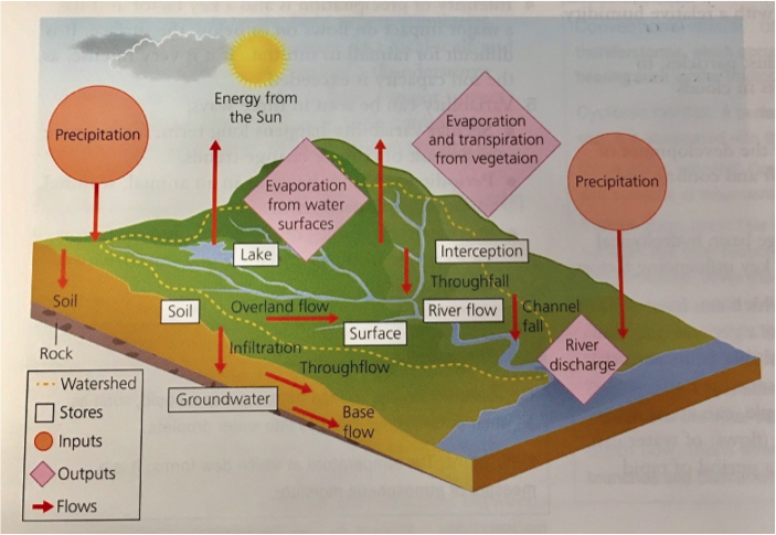
what is the hydrological cycle flows and stores
what is recharge
When precipitation exceeds evaporation causing soil moisture to increace
what are the 6 factors that increace overland flow
deforestation
steep gradient
Frozen + saturated soil
overgrazing
bare surfaces
urbanisation
What are the three types of river flow
Helicoidial
laminar
Turbulent
what are the three types of river channels
Straight
meandering
braided
what charicteristics can be atributed to braided channels
Braided channels
Trubulent flow
steep and complex system
eyots form
what are the charecteristics of a straight channel
straight channel
Laminar flow
middle and lower cource
symetrical
Rare in real life
what are the charecteristics of a meandering river
Meandering river
corkscrew motion
asemetrical
helicoidial flow
what are the four transportation process
Traction - large stones roll
suspension - small particals
soloution - disolved minerals
saltation - small stones skip
what factors effect transportation in a river
Competence - the diameter of the largest partials it can carry at a given velocity
Capacity - the total volume of load a river can carry
what are the four types of erosion
Hydraulic action - pressure of water
abrasion - scraping and rubbing of matirial
attrition - reduction in size of fragments in river
soloution - carbonates dissolved
what factors effect rate of erosion
Speed/velocity
Discharge
Climate
Geology
PH
Load
what is sineocity
curvyness of a river over time
what are the all the causes for a subdued hydrograph
Low intensity
High evapotransperation
Dry soil
permiable soil
low drainage density
gentle slopes
permiable rock
forest and vegitation
lakes
rural land
good agricultral practive