rivers unit
1/135
Earn XP
Description and Tags
mleziva rahhh (pg 69-74)
Name | Mastery | Learn | Test | Matching | Spaced | Call with Kai |
|---|
No analytics yet
Send a link to your students to track their progress
136 Terms
3 stages of river development
young → mature → old
or
upper course → middle course → lower course
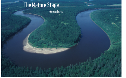
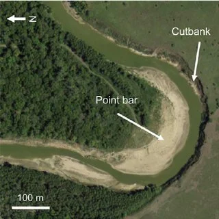
when a river goes around a bend (meander), which side gets eroded?
outer
when a river goes around a bend (meander), which side gets deposits?
inner
abrasion (river version)
rocks/pebbles in the river scrape and grind against the riverbed (bottom of river) and river banks
aka corrasion
→ widens + deepens the river channel
attrition
rocks within the river wear away at each other when they bump into each other and/or river bed
→ this rounds and smooths the rocks
→ slow process
what do u call the bend in a river
meander
what kind of valley do rivers form
v-shaped valley
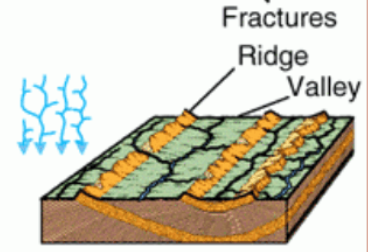
explain what an interlocked spur is and how it is formed
these features form as a result of river erosion, usually in the upper course/young stage
the river doesn’t have much eroding power → forced to pick the path of least resistance
causes river to wind around hard bedrock
forms ridges of land that protrude from opposite sides of the valley in an alternating order to create a zig-zag pattern
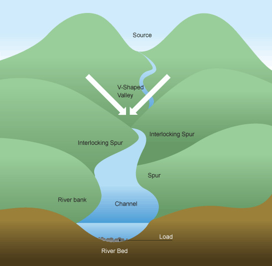
what is the name of the pile of sediments deposited by a river on the inner bank of a meander
slip-off slope or point bar
must know both terms
True or False: The mature stage of a river is faster than the young stage.
True.
The young stage looks faster bc it has white rapids + more waterfalls, however, the avg speed is slower bc there is more friction generated by the large boulders at the bottom of the river
The mature stage is faster bc the riverbed is smooth by this point → less friction, although it looks calm
what is alluvium
finely sorted and layered/stratified sediment deposited by water
SUPER fertile
mix of gravel, sands, silt clay
how is alluvium deposited
river undercuts its river bank & floods the surrounding plain
deposits a thick mass of finely sorted and layered sediment called alluvium
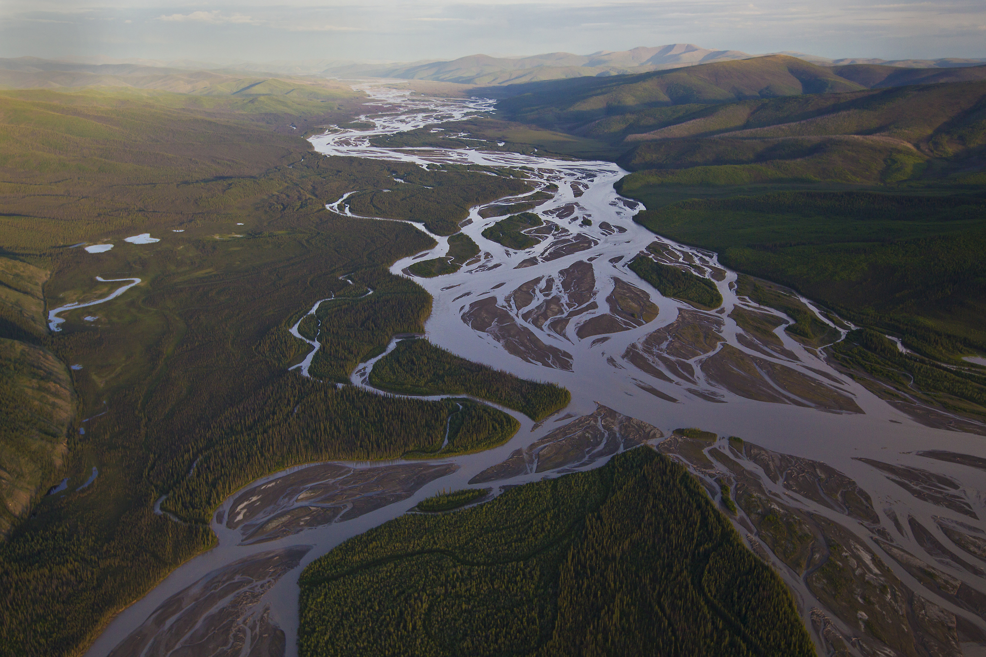
what is braiding
when a river splits off into multiple streams
→ happens when banks are soft & easily eroded + high sediment load in water
→ forms islands
→ can be temporary or permanent
estuarine delta
formed in a partially enclosed area where the mouth of a river mixes with high ocean tides
mix of freshwater and saltwater
doesn’t form a large delta bc tides sweep sediment away before it can build up
latin meaning: “tide” or “surging”
Example: France! → Seine River delta
also: Mud Bay
define point bar
aka slip off slope
the pile of sediment deposited on the inner bank of a meander/river bend
True or False: Estuaries create a substantial delta
False.
estuaries have tides sweeping in from the ocean very often → the sediment deposited by the river never gets to build up, but just gets sweeped into the ocean
→ however a small delta can form
True or False: The mature stage of a river is slower than the young stage.
False.
The young stage looks faster bc it has white rapids + more waterfalls, however, the avg speed is slower bc there is more friction generated by the large boulders at the bottom of the river
The mature stage is faster bc the riverbed is smooth by this point → less friction, although it looks calm.
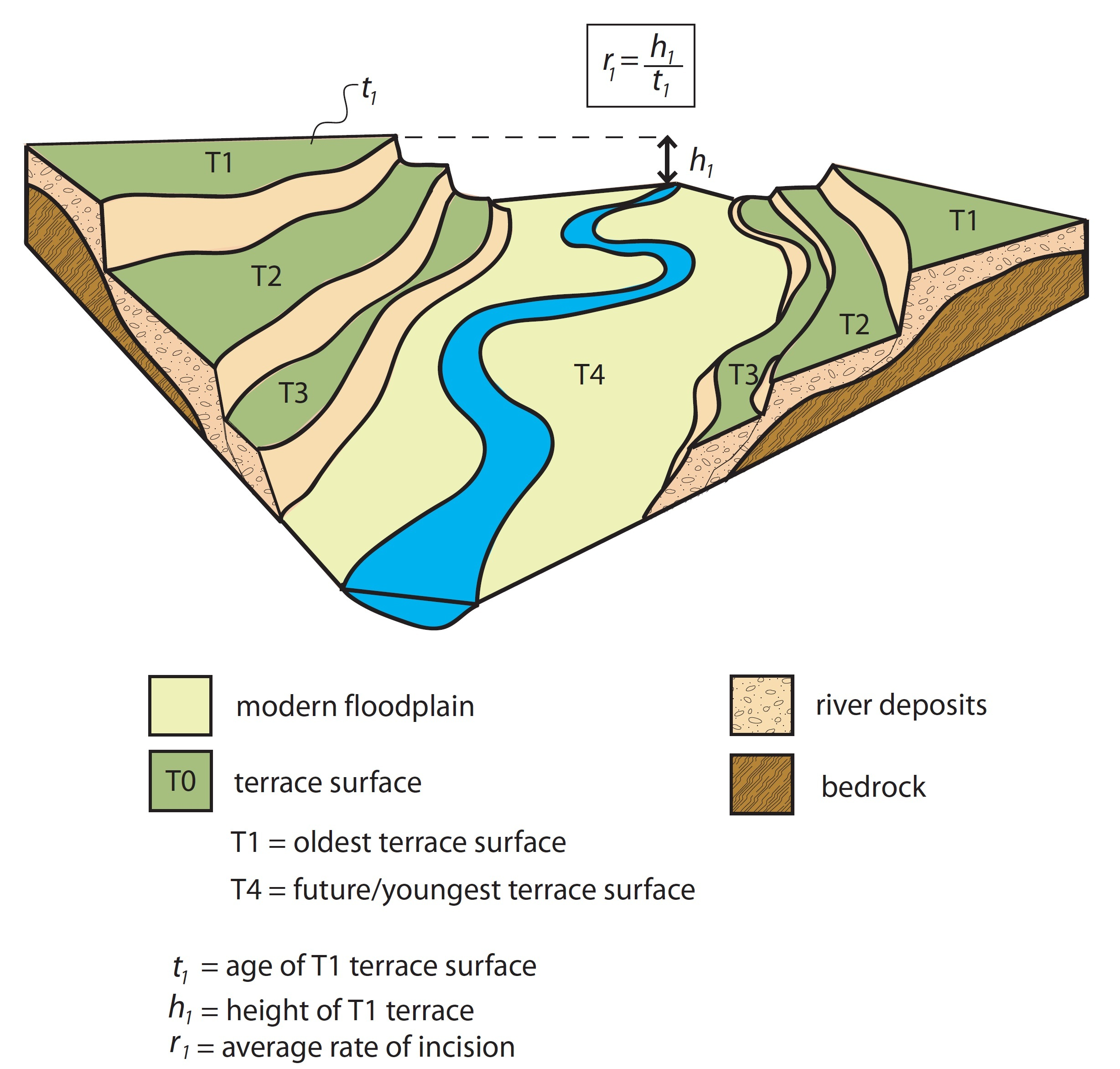
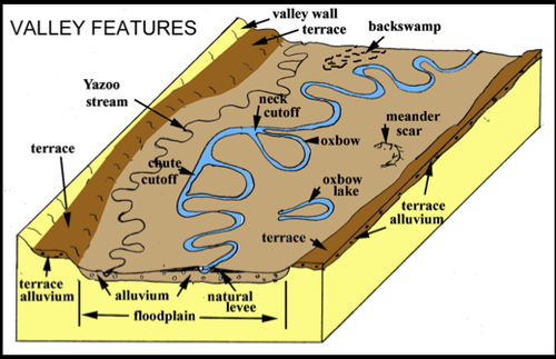
river terrace
a piece of floodplain that has been raised above the rest of the floodplain
there is an escarpment (steep slope) btwn the higher and lower parts
caused by isostatic rebound from glaciers or tectonic plate activity
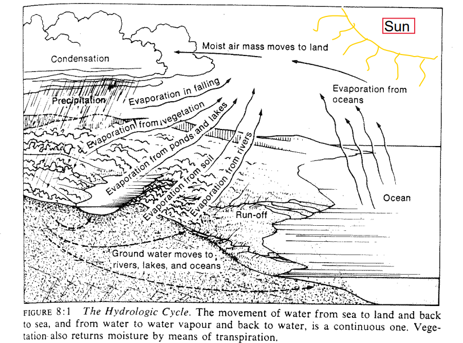
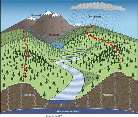
what is the hydrologic cycle + name all the places for water to go before evaporating
just another name for water cycle LOL
basic cycle: evaporation → condensation → precipitation
Note: humid air masses move towards land before precipitation
Possible Trajectories For A Water Molecule:
evaporates while it is falling
soaks into aquifers
potentially dissolves soluble minerals (corrosion)
eventually flows into rivers/lakes/ocean
evaporates from lake/pond
evaporates from ocean
evaporates from river
evaporates from plants (transpiration)
divide
aka watershed. the ridge that separates 2 drainage basins and allows water to flow off either side.
give 3 possibilities for what happens after precipitation reaches ground
it evaporates
does not do any gradation
it lands on porous rock and sinks inside
potentially weather by solution/carbonation
if this porous rock is over impervious rock, it can form an aquifer or even a spring if the water table reaches the surface
it lands on impervious rock and slides down a slope until it finds a stream/river
called runoff
It goes through a plant (transpiration)
3 main sources of water for rivers
glaciers
springs
lakes
what does the strength of a river’s erosion power depend on?
volume + velocity (V & V)
river or stream
a channel of flowing water that follows a definite course
head or source
highest point of a river
must be the first place where the river is at the surface
mouth
lowest point of a river
where river either leads into a sea/lake or joins another river
levee
high ridges of sediment (alluvium) on the banks of rivers
usually covered with vegetation bc the alluvium is so fertile
naturally deposited by river when it floods
characteristic of mature & old stages
dike
extra high ridges of sediment on the banks of rivers
man-made
→ eg to reduce impact of tsunamis
another name for watershed
divide
watershed
the ridge that separates 2 drainage basins; water flows evenly down both slopes of this ridge
not to be confused with arete
aka divide
river valley
the elongated depression in which a river flows
v-shaped bc the river doesn’t have as much vertical eroding power as a heavy glacier
river bed
the bottom of the river
aka part of the river valley that is actually covered by the river
river bank
the sides of a river valley
downstream
direction of river flow → towards river mouth
corrasion
type of erosion where sediment in the river wears away at rock surfaces that they pass over
→ synonym of abrasion
not to be confused with corrosion
is corrasion weathering or erosion
erosion bc rivers move
what are the 4 methods of sediment transportation in a river
saltation
suspension
solution
traction
SSST
saltation
French of jump: sauter
Spanish of jump: saltar
happens bc river current is inconsistent so sometimes the rocks are propelled by current and sometimes they fall to bottom
literally the rocks be bouncing/jumping along the riverbed
hopping and skipping along
suspension
rock sediments are carried by river current (not dissolved)
must be in middle of river, not the bottom
solution
dissolved rock sediments are carried by river current
traction
heavy rocks roll along riverbed
young stage/upper course
Characteristics
steep gradient
medium water discharge??
medium velocity
narrow
low sediment load
Types of erosion:
headward
vertical
makes riverbed deeper
Landforms:
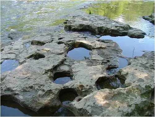
potholes
rapids
waterfalls
interlocked spurs (why not v-shaped valleys?)
gorges
Uses to humans:
hydropower (i.e. dams)
drinking water
tourism
old stage/lower course
characteristics:
low velocity
low gradient
high discharge
wide channel width
high sediment load
landforms:
yazoo streams?
wide flood plains
large levees
meanders
oxbow lakes
deltas
types of erosion:
lateral (river valley is so flat by now that erosion can only happen laterally)
this also why this stage is so wide → the only erosion happening is lateral
uses to humans:
transport
housing
flat + fertile floodplains → easy to build settlements
rivers → water supply + recreation
farming
(alluvium)
NOT for drinking water bc this river is full of sediment + farm run-off + pollutants
a river that’s efficient at transportation should actually be brown
what is gradient
slope
what is water discharge
volume of water flowing through a point in a river per second
eg. 3475 m3/s
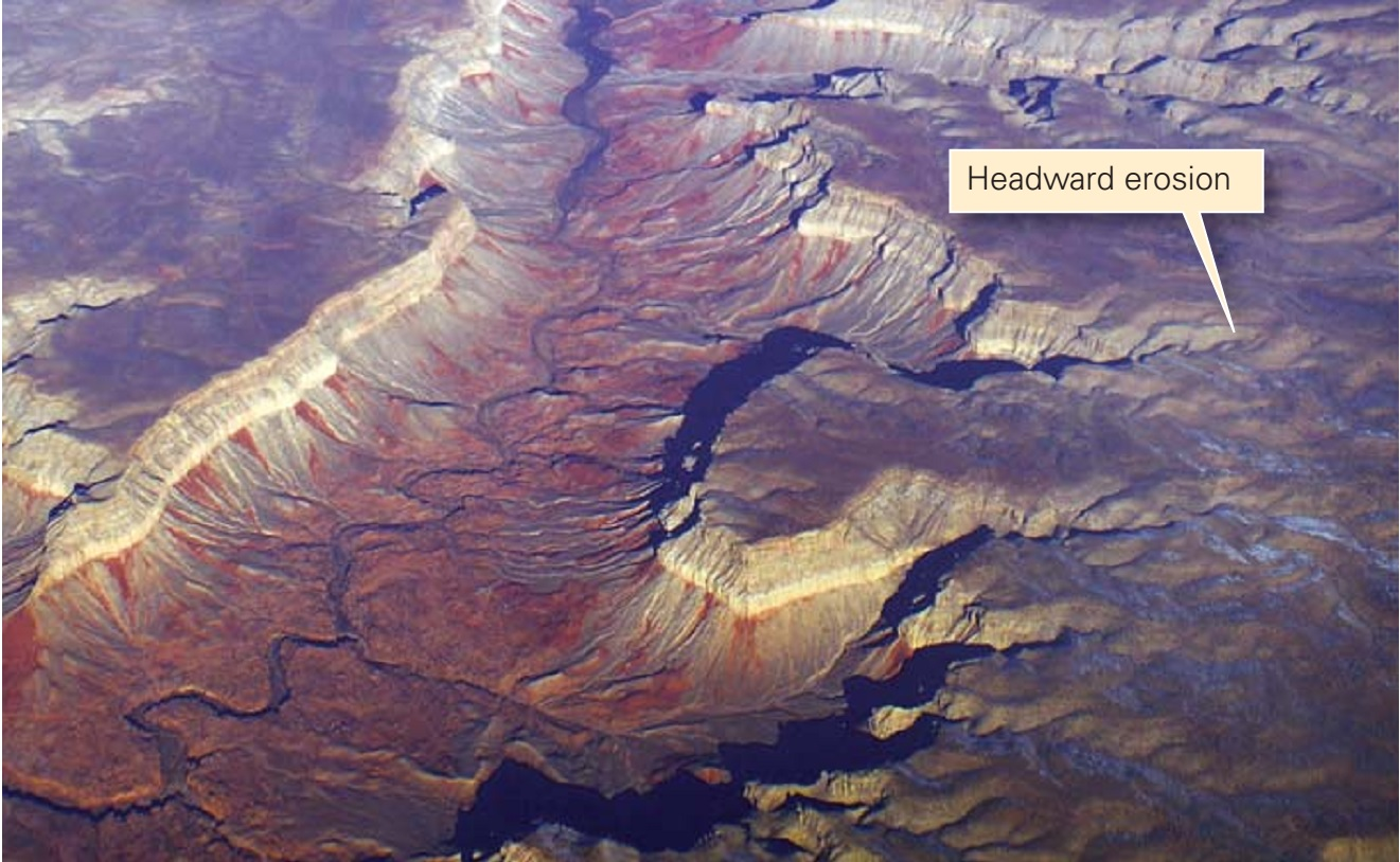
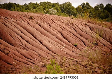
headward erosion
lengthens the headwaters or source of a river in the opposite direction from downstream/normal flow
happens bc gullies and rills on a slope get lengthened as rainwater falls and erodes them
the rain deepens the gullies and causes it to “eat back” into the hillside
towards top of slope → causes river source to move backwards
young stage
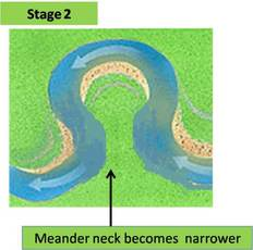
how is an oxbow lake formed
the bend in a meandering river becomes tighter over time due to erosion & deposition on the outer bank and inner banks, respectively
the bend is called a neck
eventually the neck gets so narrow that the river is able to cut through it and flow in a straighter path bc it is more efficient
as river continues to go on the new straighter path, it deposits sediment that eventually blocks off the old meander → forms a horseshoe shaped lake that is competely separated from river
mature or old stage only
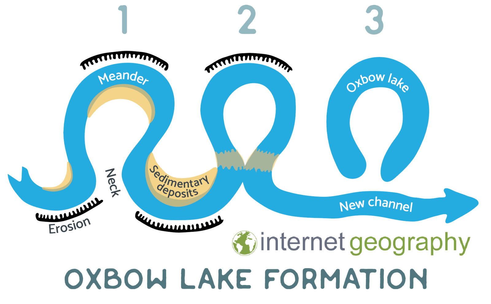
what is another name for oxbow lake
cut-off lake
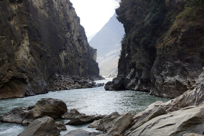
gorge
steep, rock-walled narrow valley
formed by rapid erosion of a river through hard rock
must be hard rock in order to support the steep structure of this feature. otherwise, it would erode away into a v-shaped valley
young stage
rills
small narrow channels carved by intense water erosion
when further eroded these turn into gullies
mature stage/middle course
Characteristics:
medium gradient
medium channel width
high velocity
high discharge
high sediment load
Landforms:
slip off slope/point bar
v-shaped valley (why is this not formed in young???)
flood plains
levee
Types of Erosion:
lateral (undercutting of outer banks)
Uses to Humans:
transport
housing
flat + fertile floodplains → easy to build settlements
rivers → water supply + recreation
farming
(alluvium)
hydroelectric power (dams)
fishing
NOT for drinking water bc this river is full of sediment
levee vs slip off slope/point bar
levee is deposited by the river when it floods → anywhere along river bank
slip off slope/point bar is specifically at a meander when the river deposits sediment on its inner bank bc the current slows
yazoo stream
tributary that goes rogue and meanders all over the floodplain
→ eventually rejoins main river by breaking thru the levees
how are potholes formed
young stage
formed thru abrasion or corrasion
fast water current hits a small natural hollow/weak point in the bedrock and widens it
rocks get trapped in this hollow and swirl around, futher widening it like a drill
corrasion vs corrosion
corrasion: erosion of rock underneath a river as the sediments grind + scrape past it
corrosion: dissolving of soluble minerals in a rock by water
this usually happens with limestone in humid areas

pls explain difference btwn potholes and kettle lakes
potholes:
carved from bedrock
river erosion (young stage)
abrasion + swirling of small rocks trapped in a hollow → pothole
kettle lakes:
formed by meltwater deposits
glacial deposition (retreating)
solid ice block remains while meltwater deposits sediment around ice block → kettle lake
discharge
volume of water (in a river)
hydraulic action
erosional force caused by the pressure of the water pushing against side of a river bank
→ in coastal landforms, the water gets into cracks and compresses the air already inside. when the water leaves, the compressed air rushes out and shatters/breaks apart the rock
Examples: waterfall hitting the ground creats a plunge pool, river in a meander eroding the outer bank into a cut bank (undercutting)
Plunge pool
The pool of water at the bottom of the waterfall created thru hydraulic action
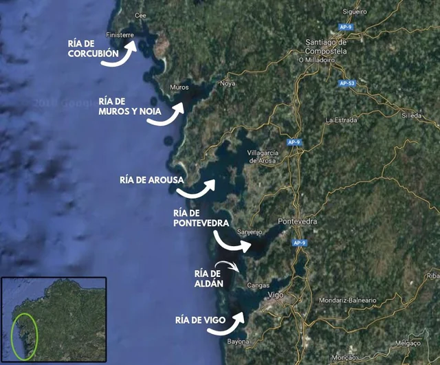
ria
a flooded or drowned v-shaped river valley
connects to the sea
long, narrow inlet
similar to fjord but it is an unglaciated valley
when do deltas form
when a river reaches base level
what is a cut bank
the outer bank of a river meander
the one that gets eroded by hydraulic pressure

base level
the lowest point to which a river can erode
typically an open ocean or lake
river deposits ALL of its remaining sediments here
usually forms a delta
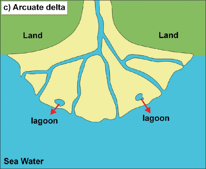
Cuspate delta
Caused by a single tributary emptying onto a flat coastline and hitting the ocean tides head-on
→ the sediment deposits get pushed back by the ocean waves behind the mouth → forms 2 cusps
(It looks like a tooth)
Very rare
Example: Tiber from Italy
neck of meander
narrow point in the u-shape (just look at the picture)
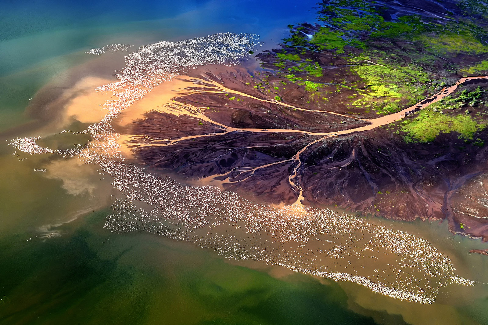
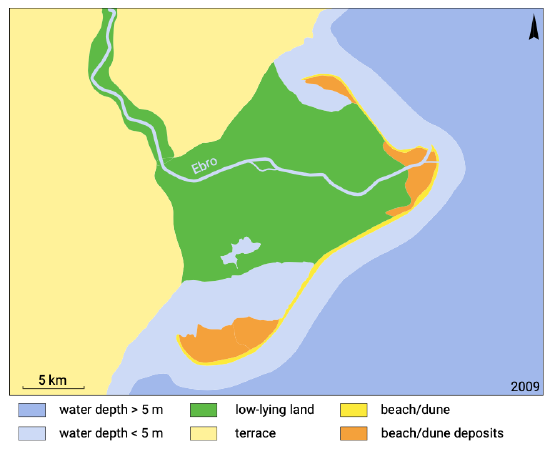
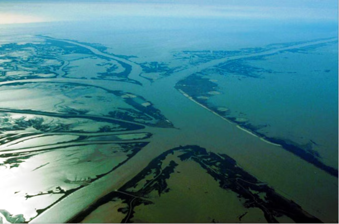
what is a delta (bonus what type is this picture?)
land that is formed by accumulation of deposited sediment at the mouth of a river where it has reached base level and is depositing all of its sediment
for delta to form (and grow) the amount of sediment deposited must be greater than amount swept away by ocean tides
eg. richmond and delta
this picture is an arcuate delta (same type as richmond/delta)
types of deltas
arcuate
estuarian
bird’s foot/digitate
cuspate
arcuate delta
rounded or bow-shaped delta
large amount of sediment is distributed by many tributaries
sea currents round the delta by dispersing the sediments into a fan shape
often has lagoons
lagoon: a small isolated body of salt water separated by sediment or other stuff
eg. Fraser River or Nile River
bird’s foot delta
aka digitate
many tributaries split up from the main river
each tributary deposits sediment along its banks, which forms a lot of new land in btwn the streams
resulting delta stretches in various directions and resembles a chicken claw
requires heavy discharge
eg. Mississippi River
lagoon
a small isolated body of salt water separated from the ocean by sediment or a delta or some other type of ridge
tributary
stream that ADDS volume to a river
young stage
distributary
stream that SPLITS up river into smaller sections
old stage
another name for bird’s foot delta
digitate
need to delete this card
need to delete this card
rejuvenated river
rising of land gives rivers fresh power to erode bc of a steeper slope (just like young stage again…good ol days)
either caused by isostatic rebound (after glacial retreat) or tectonic plate movement
google said also could be caused by drop in sea level
can form waterfalls at knick points
knick: a sharp change in gradient in the slope of a river channel
knick point
a sharp change in gradient in the slope of a river channel
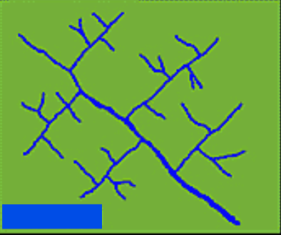
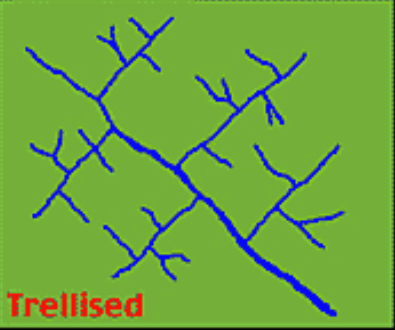
trellis drainage
occurs on bands/strips of soft and hard rock
the soft rock gets eroded away by the river
→ forms v-shaped valley
tributaries join the main river at the bottom of the valley at near right angles
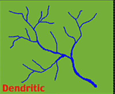
dendritic drainage
occurs when the rock has a uniform or even hardness
water flows randomly
pattern is similar to the veins in an oak leaf
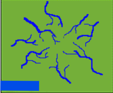
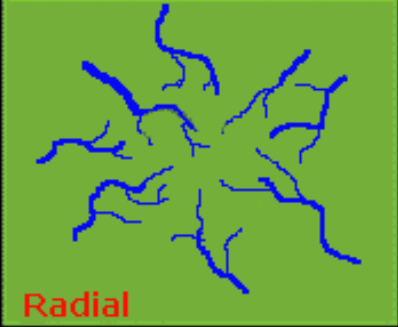
radial drainage
occurs on a steep mound or volcanic neck
water flows from the peak/center of the cone in all directions
intermittent drainage
occurs when there is infrequent, irregular precipitation → arid climate
these streams only flow when the water table rises
creates all sorts of different landforms
what is the drainage in glaciated landforms like?
lots of small lakes/ponds/rivers scattered all over the Shield, due to glacial erosion
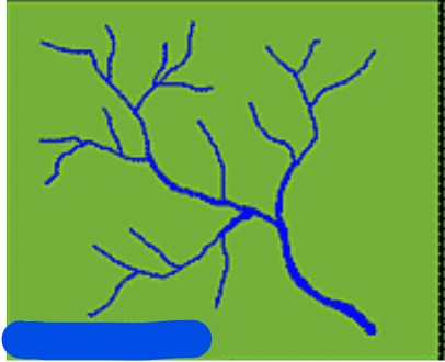
what is this drainage pattern
dendritic
what is this drainage pattern
radical
what is this drainage pattern
trellis
what is this drainage pattern
trellis

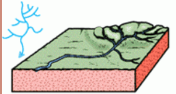
what is this drainage pattern
dendritic

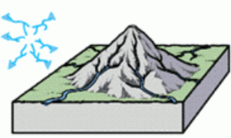
what is this drainage pattern
radial

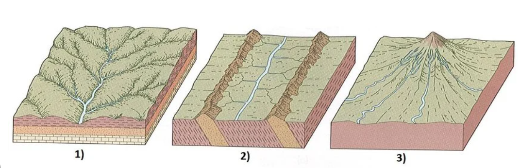
please indicate which type of drainage pattern these 3 basins are showing
dendritic
trellis
radial
corrosion vs solution (in the rivers unit)
corrosion: when water dissolves soluble rock minerals
→ type of erosion
solution in rivers unit: transportation of soluble sediments in the river AFTER corrosion causes water to dissolve these
→ type of transportation, does not include breaking the rock down
what factors are causing the mississippi river delta to stop growing as fast?
increase in irrigation so the river discharge is much less
sediment is also less → less deposited at mouth
increase in dikes
prevents river from depositing sediment along its banks, and it is forced to carry all of its sediment load until deep into the ocean where it is swept away by strong tides (in Gulf of Mexico)
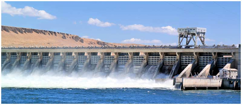
what are the pros and cons of dams ABOVE the dam?
Pros:
hydroelectricity
farming
alluvium is fertile
irrigation channels
tourism & recreation
fishing, boating
drinking water supply
Cons:
can harm aquatic ecosystems + wildlife
can impact fish migration & spawning grounds (Salmon?)
expensive to build
too much sediment build-up can lead to high water levels in the river
flood risk unless you dredge, but:
may harm salmon spawning grounds if you do dredge
sediment can clog turbines
humans have to resettle because a large area of land will be flooded
weight of dam may cause earthquakes LOL
what are the pros and cons of dams BELOW the dam?
Pros:
flood control
hydroelectricity
Cons:
lack of nutrients for aquatic ecosystem → sardines + general fishing affected
loss of natural fertilizer from river sediment
farmers must rely on chemical fertilizers
loss of deltas + natural wetlands over time
increased water seepage into groundwater resources can lead to rising water tables in aquifers → weakens building foundations
expensive to build
can harm salmon migration patterns who want to reach spawning beds
difference btwn cut bank and point bar
cut bank: outer edge of river meander in the mature or old stage
point bar (aka slip off slope): inner edge of river meander
Key differences:
cut bank is carved through strong erosional forces as river is faster in outer bend
point bar accumulates alluvium deposits as the river is slower along the inner bend
Give a famous river example for each of the following delta types:
Estuary
Arcuate
Bird’s Foot or Digitate
Cuspate
Estuary: Seine, France
Arcuate: Nile, Egypt
Bird’s Foot or Digitate: Mississippi, USA
Cuspate: Tiber, Italy
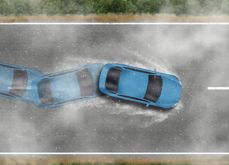
hydroplaning
tires lose contact with road because water level is too high
→ causes skidding
→ potential issue in urban areas with high flood risk
Poor ways to manage a river basin:
POD causes increased erosion + runoff in a drainage basin:
P: Poor farming techniques
i.e. building farming patches against contour lines on a hill
O: Overgrazing
D: Deforestation
Good ways to manage a river basin:
Peter Rabbit Runs Barefoot During Daytime Carrying Potatoes
P: Plough with the contours or terrace farm on slopes
R: Ranchland management → restrict cattle grazing in fenced-off areas
R: Reforestation
B: Build dikes
D: Dam
D: Dredge excess sediments to increase river carrying capacity
→ has limitations (salmon spawning grounds)
C: Canals to redirect water
→ i.e. make reservoirs, irrigation channels for drinking water
P: Preserve Wetlands
river basin
an area of land drained by a river + its tributaries
→ can be a single stream or a whole network
pretty much same as drainage basin
In which setting is the rate of runoff greater?
Urban
because we have drainage systems (pipes, drainage holes) that rapidly transport water away
lack of vegetation that slows down water runoff
building materials (concrete, asphalt, glass) resist water absorption
buildings designed to keep water out
In which setting is the rate of evaporation greater?
Urban
This is because of the urban heat island effect
→ concrete, asphalt, glass all absorb heat during the day and radiate it at night
causes an increase in avg temp. during the night
warmer temp = faster evaporation
→ also these materials do not absorb water so any leftover water must be evaporated with time