Marine Ecological Processes Final Exam
1/83
There's no tags or description
Looks like no tags are added yet.
Name | Mastery | Learn | Test | Matching | Spaced | Call with Kai |
|---|
No analytics yet
Send a link to your students to track their progress
84 Terms
Lecture 7: Tides
what are tides?
a periodic, short term change in the height of the ocean surface at a particular place, caused by the gravitational force of the moon and sun as well as the rotation of the earth-moon and the earth-sun
they are the longest of all ocean waves, their wavelength can be have the circumference of earth (around 20,000 km). the crests of these long waves represent the high tides, which le troughs create the low tides
what theories explain the tides?
the equilibrium theory of tides: explains tides by examining the balance and effects of forces that allow earth to stay in orbit around the sun, and the moon to orbit earth
the dynamic theory of tides: takes into account seabed contour, water viscosity, and tide wave inertia (shallow water wave). explains the characteristic of ocean tides based on the gravity/interia of the sun and moon and the characteristics of fluid motion
together these theories allow tides to be predicted years in advance
what does newtons law say about tides?
any tow objects have a gravitational attraction to each other. gravity is proportional to m1m2/distance
the magnitude of the force is proportional to the masses of the objects and inversely proportional to the cube of the distance between the objects. the greater the masses of the objects, the greater the gravitational force and the farther apart, the weaker the force
why is the center of rotation (barycenter) closer to earth than the moon?
because the mass of earth is 82 times larger than the mass of the moon. this makes the center of rotation lie within earth (1600 km below the surface), making it seem like the moon is rotating around the earth
the inertial force has the same magnitude everywhere on earth and is always directed away from the moon.
what are the inertial and gravitational forces in the earth-moon system? how do they combine to make the tides?
the inertial force has the same magnitude everywhere on earth and is always directed away from the moon.
the gravitational forces is always directed towards the moon and is stronger on the side of the earth closest to the moon
at the center of the earth, the gravitational force and internal force are equal and cancel echoer out. on the side of the earth closer to the moon, the inward graviational force is greater than the outward internal force, resulting in a force that is directed towards the moon, creating a bulge of water on the side facing the moon. on the side of earth furthest from the moon, the inward gravitational force is less than the outward inertial force, resulting in a force that is directed away from the moon, creating a water bulge directed away from the moon
how does the sun affect the tides?
the sun has around 46% the affect on tides as the moon does (the moon is stronger), so the sun creates its own, smaller water bulges independent of the moon’s. seasonal differences in the position of the sun relative to the earth’s 23.5° incarnation affects the solar toes at a slower rate than the monthly variation in lunar tides
what are the types of sun-moon tides(2)? what are the types of tidal patterns (3)?
spring tides: when the sun, earth, and moon are aligned during full and new moons, the solar and lunar bulges are also aligned, and add to each other (constructive interference), creating the highest tidal ranges (high high tides and low low tides). occurs every 2 weeks
neap tides: when the sun, earth, and moon are 90° to each other during the ¼ and ¾ phase moon, the solar and lunar bulges are out of phase and cancel each other out (destructive interfecence), creating the lowest total ranges (highest low tides and lowest high tides). occur every to weeks
semidiurnal: tides that occur twice each lunar day, two high tides and two low tides of nearly equal level.
most common along the east coasts of North America and austrailia, the wast coast of Africa, and most of Europe
diurnal: tides that occur once each lunar day, one high tide and one low tide
most common in the Gulf of Mexico, along the west coast of Alaska, and in parts of Southeast Asia
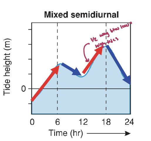
mixed semidiurnal: semidiurnal tides with significantly different heights through the cycle. the differences in height may be due to amphidromic circulation, the angle of the moon, or other variables
most common along the pacific coast of north america
what are the lunar months?
they are complicated
sidereal month: 27.322 days for the moon to complete a full rotation around the earth
synodic month: 29.531 days for the moon to travel from one phase to another(>360°) because the earth is traveling in its orbit around the sum (this is the lunar month)
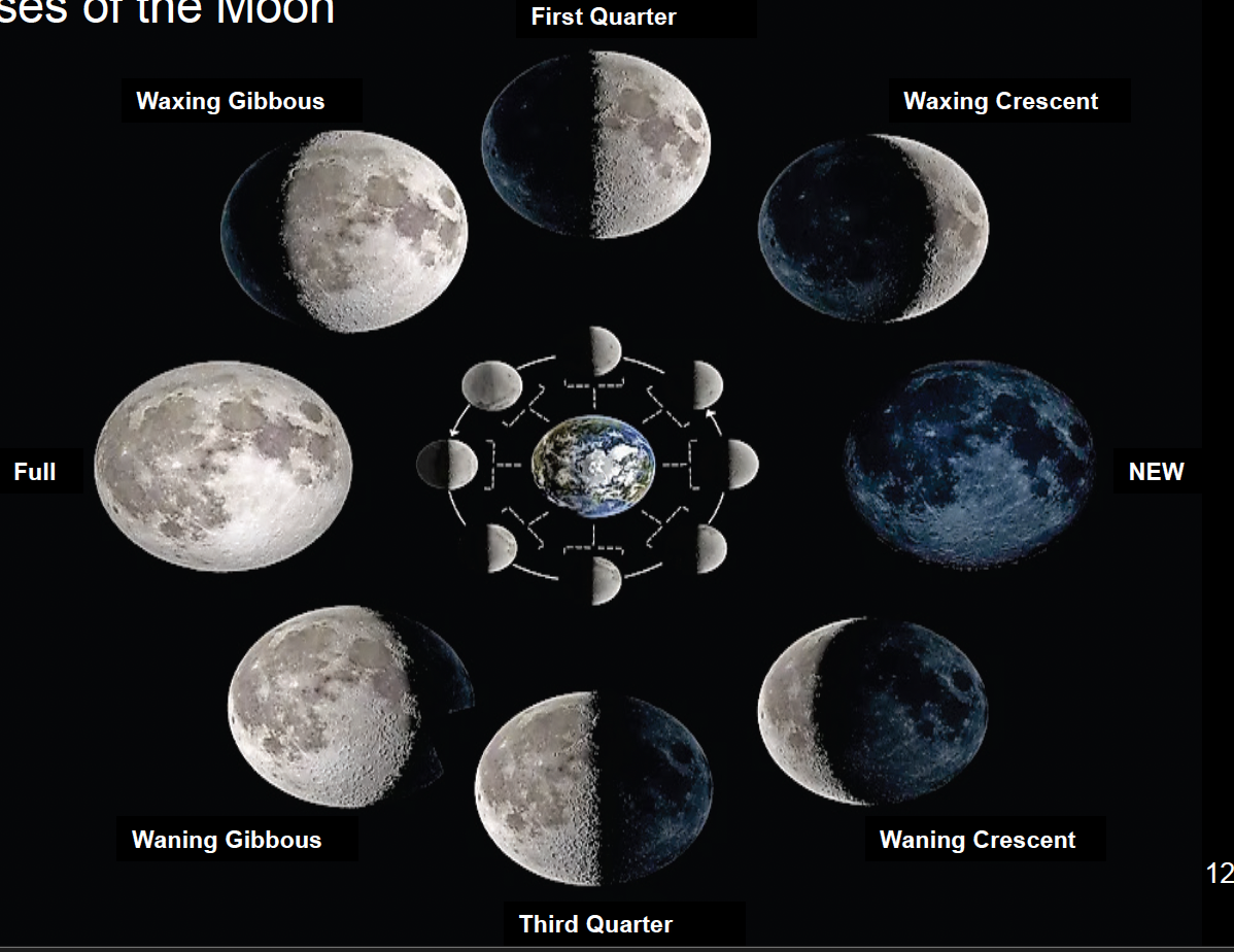
what are the phases of the moon?
new moon
waning crecent
third quarter
waning gibbous
full
waxing gibbous
first quarter
waxing crescent
what are amphidromic points? what is the amphiromic system?
nodes at the center of the ocean. there are around 17 of them around earth (the pacific has 5 because it is so large)
the amphidormic system is gyre-sized tidal patterns where a tidal crest rotates around an ocean basin with rotation occurring at the amphidromic point/node. the tidal crest radiates outward from the ampidromic point and extends to the basin’s edge. the tides move counterclockwise in the northern hemisphere (opposite of coriolis) and the tidal ranges increase with increasing difference from the amphiromic point.
as the the tidal crest is reflected back across the ocean basin, its path is deflected by the coriolis force, causing the crest to head in another direction than its tendency, the crest hits the land and would tend to be reflected once again but would be deflected by coriolis, resulting in instead of a simple standing wave, the tidal crest follows a circular pattern around the ocean basin
why do we get diurnal and mixed tides if semidiurnal tides are what are expected given the gravitational and internal tides?
because the interaction of flow in ocean basins, because tides are shallow water waves, their speed is dictated y the ocean basin depth (not uniform)
because the continents get in the way of the tide
because of the coriolis effect
what is the dynamic theory of cotidal lines?
tides move as progressive waves or as rotary standing waves near the coasts
cotidal lines are tidal crests that occur at the same tine on the line (one rotation is around 12 hours)
what is the basin geometries that can affect amplicromic systems (3)?
confined basins: ie. a bay, leads to a rotary standing wave on a 12 hour cycle
broad basins: ie. amphidromic systems,
narrow basins: ie. tidal bores, no rotary system (no amphidromic point) leading to a progressive wave
what is a tidal bore?
a tidal wave (usually less than 1m high and less than 4-5m/s(can be 8m and 11m/s) that rushes over the top of the water already in a basin
where are the largest tidal ranges found?
at the edges of the largest ocean basins, bays, or inlets that concentrate shape and experience resonance (energy of wave going in can’t go forward, must go up, leading to a slice or standing wave)
what is tidal datum?
tidal datum is a reference to(the zero) and is used to compare the high and low tides, this is not always the mean sea level
in a mixed tide the mean lower low water
in diurnal and semidiurnal the mean low water
what is the maximum current and how does it differ in oceans?
the maximum current is halfway between low and high tides
it is slow in open oceans and fast in some coasts
lecture 8: seawater chemistry
where is water located on the earth (percentage)? how much is on the earths surface?
1.37 × 10⁹km3 of water is on the surface of earth
97.5% is in the oceans (96% is water, 4% is salt)
1.8% is in glaciers and icecaps
0.64% is freshwater
what is the hydrological cycle? what is the residence time of water in the oceans and atmosphere?
the continuous movement of water on above and below the surface of the earth (evaporation-precipitation)
in the oceans, the residence time is around 4100 years, and around 9 days in the atmosphere
there is around 46,000 km3 of excess water on continents and around -46,000 km3 of water lost to evaporation in the ocean (when looking at evaportation-precipitation)
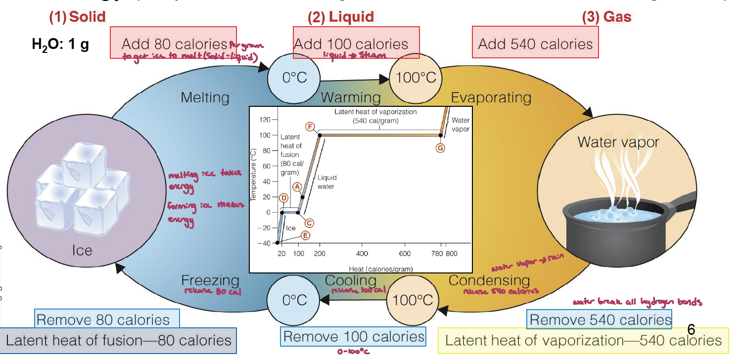
what is the chemistry of a water molecule? what re the. thermal properties of water? how much energy (calories) are needed to change the phase of water?
covalent bonds hold two H atoms and one O together, this leads to polarity with asymmetrical positiove and negative sides, hydrogen bonds form between the negative and positive ends of water molecules (contributing to their solvent properties)
water is cohesive, leading to the ability of water molecules to stick to echother (surface tension)
what also has adhesive properties, the tendency of water molecules to stick to other substances
water has a high heat capacity (measure of the heat/claories required to raise the temp of one gram of a substance by 1°C) and resists changing temperature when heat is added/removed, helping to regulate thermal inter
land temperature ranges from -90 to 50°C (140°C range) while ocean lanes from -2 to 32°C (34°C range)
solid→liquid: add 80 calories
liquid→steam: add 100
liquid→gas: add 540
remove calories to go in opposite direction
how does ice formation affect energy flux and temperature regultation?
fall cooling is delayed by ice formation (spring heating is also delayed), meaning that the fall does not get as cold as it should be. this is due to the Gulf Stream with carries 550 ×1012cal/sec north, while ocean evaporation is around 1m/yr, amounting to 334,000 km3 of water (540×1014cal/g)
each year 20 million km3 of ocean thaws and refreezes in the southern hemisphere, every freeze releases energy into the environment and every thaw takes from the environment (atmospheric)
why is water a solvent?
Polar compounds are solutes that are easily hydrated
Non-polar (don’t dissolve as easily) compounds are less so because they cannot fill the spaces between the water molecule (limited solubility)
Salt is a compound comprised of a cation (+ve) and anion (-ve) that typically dissolve in water
an Ion is a molecule with unbalanced charge; move through water in solution by diffusion
Saturated – no more salt will dissolve
Precipitate – forming salt crystals from solution
salt solutions are elecrically neutral if charges are balances (positive=negative); conduct electricity
what is salinity? why does it have spatial variation?
concentration of dissolved inorganic solids in seawater. Each kg of seawater ~35 g dissolved salts, there are 5.0×10¹⁵ kg total salts in the ocean
Variation due to evaporation, precipitation, and inflowing rivers, especially in coastal regions and polar regions
salinity is a function of how much water there is (precipitation vs. evaporation). at horse latitudes it is warm and dry, leading to evaporation, while cold air holds less water, leading to precipitation
what re the colligative properties of salinity?
↑ Salinity → ↓ Heat capacity (less energy needed to melt ice), ↓ Freezing point, ↓ Evaporation, and ↑ Osmotic pressure
how does the density of seawater vary?
varies between 1,010 and 1,030 kg/m3 and increases its decreasing temperature and increasing salinity.
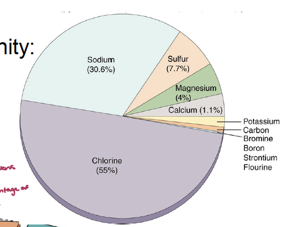
what is sea water made of?
it is made of 14 major elements and over 40 trice elements. while the total salts in the water can change, the properties will not (the percentages of what it is made of will not change)
there are around 17 non-conservative trace elements that change due to them being envolved in biological processes, they have a short residence time
there are also conservative ones which can be sured as indicators for water movement, they have a long residence time
what is nutrients
around 30 elements necessary for life
biomolecules
body fluids
skeletal structures
major nutrients:
CO2, O2, ammonium, nitrate, phosphate, sulfate, silicate, ireom
minor nutrients: needed for some enzymes, small amounts needed
Mn, Co, MO, Cu, Zn
Cu and Zn at high coencentrations are no longer minor nutrients and become toxic
what is CDOM?
colored dissolved organic mater (or humic acids): recacitrant but is the basis for the microbial loop
what are TEIs? how do they make HNLC regions?
trace elements and their isotopes
high-nutrient, low-chlorophyll regions have a low abundance of phytoplankton and is constant despite the available macroniteints (surface ocean where growth is limited by Fe and Zn)
Fe is limited by micronutrients, due to it being used in the ETC in photosythesis
Zn is used in carbonic anhydrase
“iron fertilization
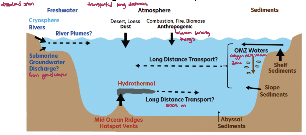
what is dFe?
dissolved iron: 0.2 or 0.4 μm pore size (p-nmol/kg) is the source phytoplankton use. Has 0.83 yr surface residence time with input from aeolian dust (↓25%), reductive sediments (iron can settle in anoxic/hypoxic sediments), hydrothermal (come out of hydrothermal vents), rivers as sources.
First measured reliably 1980s; only 25 depth profiles worldwide by 2003 and dust considered most important. later GEOTRACES (2004-present; 35 countries) >16,000 obs. with multiple dFe sources with long distance transport
dissolved gasses from the atmosphere?
dissolved gasses from the atmosphere contribute to seawater solubility
15% of CO2 in ocean vs. 0.04% in atmosphere
45% of N2 in ocean vs. 78% in atmosphere
36% of O2 in ocean vs. 21% in atmosphere
what is ocean deoxygenation?
Climate warming is an increasingly important factor driving the decline in DO saturation.
Coastal seas and estuaries: driver is over-fertilization of water primarily from agriculture, sewage, and the burning of fossil fuels (more N and P into these areas, microbial loop stuff happens, leads to less oxygen).
Open ocean, changes in circulation leads to upwelling (EB) of oxygen minimum zones (OMZ; severely oxygen-depleted waters typically several 100s m deep).
as of 2020 there are over 700 sites of eutrophication-induced hypoxia. this could lead to hydrogensulfice buildup in the water column, which is toxic to everything as it attaches to hemogobin better than oxygen)
consequences:
loss of biomass
loss of biodiversity
lower food web complexity
altered energy and biogeochemical cycling (metals can come back out of solution and can be toxic)
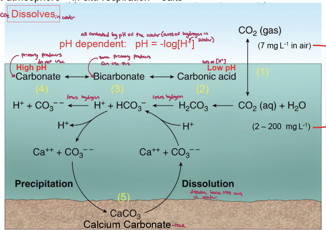
what are the sources of Co2 in the ocean? what controls it?
atmosphere, respiration. and carbonate salts
pH of the water dictates the amount of hydrogen in the water.
respiration decreases pH, CaCO3 settling increases pH, and loss of buffering capacity at CCD decreases pH
there is an increase in ocean acidification because of increased atmospheric CO2 uptake into the ocean
almost all DIC in seawater is bicarbonate, which is not the preferred source of inorganic carbon used by primary producers
how can ocean chemistry be sampled?
crewed measurements
autonomous measurements
surface (wave glider, sail drone)
water column (oculus glider, argo float)
remote measurements
surface moorings (tropical moored buoys)
column/bottom moorings
column (hydrophone)
bottom: CTD-rosette, prawler, ROV)
Lecture 9a: pelagic ecosystems - primary production
light quantity and quality?
light quantity and quality attenuates with depth
light in the coastal ocean is lower than the open ocean due to lots of erosion runoff absorbing light and biological things absorbing light
what are the sizes of plankton (7)?
Megaplankton: metazoans; jellyfish; ctenophores; salps, pyrosomes (pelagic Tunicata)
Macroplankton: metazoans; Pteropods; Chaetognaths; euphausiacea; medusae; ctenophores; salps, doliolids and pyrosomes
Mesoplankton: metazoans: copepods; medusae; Cladocera; Ostracoda; Chaetognaths; pteropods; Tunicata; Heteropoda
Microplankton: large eukaryotic protists; most phytoplankton; Protozoa (Forams); ciliates; rotifers; juvenile metazoans - copepod nauplii
Nanoplankton: small eukaryotic protists; small diatoms; small flagellates; Pyrrophyta; Chrysophyta; Chlorophyta; Xanthophyta (algae)
Picoplankton: small eukaryotic protists, monera; bacteria; cyanobacteria, Chrysophyta
Femtoplankton: marine viruses
what are some themes for sampling plankton?
concentration specimens
plankton net
bongo net
collecting water
niskin sampler
rosette sampler
non-invasive
acoustic profiler
why are phytoplankton important? biological pump?
phytoplankton make up around 90-96% carbohydrates in the ocean surface (water, sediments, rocks).
the biological pump: conversion of CO2 and inorganic nutrients in the euphotic zone into POM transferred to the deep ocean
what is the NPP in the ocean? how much carbon is bound by a single diatom per year?
NPP is around 50×10^9 tonnes of carbon/yr (making up 50% of the global total NPP)
typically ocean primary productivity in the water column will bind 120 grams of carbon into molecules of glucose each year
what are the nutrient inputs?
coastal riverine, runoff, and submarine discharge
coastal upwelling and OM remineralization (microbial loop)
atmospheric inputs and N fixation (by microbes and lightning)
oceanic upwelling from mode (where waters were mixed) and intermediate waters (undercurrents bring back up)
oceanic upwelling from bottom waters (in pacific and Indian oceans, takes 1000s of years)
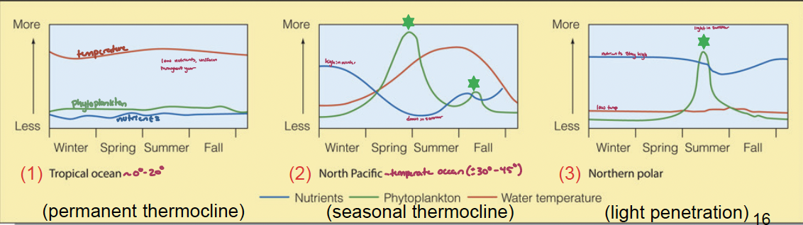
what are the temporal patterns of phytoplankton?
how can chlorophyll concentration be determined?
Chlorophyll a concentration: an aggregate proxy for phytoplankton
Filtering Water Samples
Relevant filter types
Glass fiber filters: submicrometer retention, binder free e.g., glass fiber – Chl a, TSS (good for ashing)
filter papers: both quantitative and qualitative (cotton), load capacity, retention/flow rate, purity, hardness, chemical resistance e.g., cellulose acetate – DOC
Polycarbonate filters
membrane filters: surface (smooth) filter, > 0.02 um, microbes e.g., PTFE – resistant to acids/bases/solvents
Filtration apparatus: sink aspiratior pump, magnetic (Büchner) filter funnel
Filtration setups: can be used to measure total suspended solids, DOC vs. POC)
Chlorophyll extraction
extraction: Polar solvent (acetone, methanol) in dark and cold Spectrophometer at specific wavelength
fluorometry: no filtration needed (no extraction) - measure what is in the water
what is a characteristic/trait of each phytoplankton group that sets them apart?
phytoplankton
cyanobackteria
stramenopiles (Ochrophytes):
Bacillariophyta, Phaeophyta
haptophytes
alveolates
pyrrophyta
phytoplankton: plasmid endosymbiosis
cyanobackteria: heterocysts
stramenopiles (Ochrophytes):
Bacillariophyta, Phaeophyta: energy
haptophytes: coccolythophores
alveolates
pyrrophyta: mixotrophy
what are the three main classifications of phytoplankton (size)?
Picoplankton (0.2 – 2 μm: cyanobacteria)
Nanoplankton (2 – 20 μm: cyanobacteria, coccolithophores)
Microplankton (20 – 200 μm: diatoms, dinoflagellates)
what is the primary storage, secondary pigments, and examples of the following:
cyanobacteria
stramenopiles
Bacillariophyta
Phaeophyta
haptophytes
alveolates
cyanobacteria
storage: cyanophycean starch and oils
secondary pigments: chlorophyll B, carotenoids (β carotene, xanophylls), and phycobilins (phycoerythrin, phycocyanin) - can adjust their secondary pigments according to their environment (chromatic adaptation)
examples: prochloron, prochloroccus (responsible for 70% of ocean photosythesis), synechococcus (nutrient poor tropical waters), tricodesmium, anabaena
stramenopiles: eukaryotes with flagella (mistigonemes)
storage: laminarin
secondary pigments: chlorophyll c, β carotene, fucoxanthin
examples: diatoms, brown algae, dictyochales
Bacillariophyta: Cell wall is a siliceous frustule (two pill-box valves (SiO2)) 55% efficient converting light into chemical energy. live in High latitudes, coast, upwelling - centric (radial symmetry) or pennate(bilateral) in shape
Pigments: c carotenoids (fucoxanthin)
Storage: Oil and Laminarin
example: diatoms - chaetoceros, coscinodiscus, odontella, triceratium, nizschia, thalassionema
Phaeophyta
haptophytes: Algae with 2 simple flagella for locomotion and a haptonema; small or absent in photosynthetic ones. ~50% ocean CaCO3 precipitation
storage:
secondary pigments:
example: coccolithophores, isochrysis (golden-brown algae)
alveolates: globular, 2 heterokont flagella Short flagellum in cingulum (spinning), long in sulcus (forward) Armored & unarmored dinoflagellates with dinosporin in plates
storage: starch
secondary pigments: Chlorophyll c, β-carotene, peridinin (xanthophyll),
example: dinoflagellates - dinophysis, ceratium, hymnodinium, gonoyaulax, protoperidinium, noctiluca (bioluminescent)
what are HABs? what condition can be caused by diatoms?
harmful algal blooms: Often caused by dinoflagellate population explosion with red or brown colour (red/brown tide). Occurs within dinoflagellates that can/may produce toxins, leads to reduced DO concentration
affect curscean, fish and vertebrates, but not necessarily shellfish (blue mussels can take in toxins well)
diatoms can cause amnesiac shellfish poisoning, affecting metabolism
lecture 9b: consumers
what happens to primary productivity, trophic levels, efficiency, and fish production between ecosystems (oceanic, shelf, and upwelling)
low nutrient ecosystems (oceanic) have lower primary productivity (nutrients), more trophic levels, lower efficiency, and lower fish production
productivity can be calculated as Ptrophic level = P1Etropic level - 1
how can zooplankton be measured?
echo sounder: provide estimates of planktonic biomass in specific frequency (size) range. 83% total ocean biomass concentrated in top 200 m
Deep scattering layer (dark colour) is visible during the day (at ~700 m - level with lots of rings that diurnally migrate) but the layer moves close to the surface after sunset and then downward before sunrise - happens daily
what causes patchiness in the open ocean?
upwelling, sea surface variations (SST on 100 m scale) vertical mixing, downwelling, waters of different densities, grazing by zooplankton …
what are the two types of zooplankton protists that have hard shells? what makes them different?
Foraminifera: CaCO3
Radiolarians: SiO2, use spines & pseudopods to capture diatoms
what are larvaceans (appendicularia - chordates)
Suspension feeders of phytoplankton in pelagic & photic zones
generally small
House (test = protein + cellulose) is large and is discarded regularly, contributing to OM flux to deep sea. Tail beating generates current that captures nanoplankton (2→20 μm) effectively
what zooplankton makes up 70% of holoplankton abundance? what are the types
copepods
Calanoid, (dominant)
Cyclopoid (Benthic)
Harpacticoid (benthic)
what are the two major groups of whales?
Mysticeti: suspension feeders
odontoceti: active predators
lecture 10: coasts
there is more net primary production on the land side of coasts (estuaries, swamps, marshes)versus the ocean side (open ocean) but in therms of total NPP, this is flipped
what are the ecosystem services of coasts?
Comprise ~ 20% of the Earth’s surface
acts as a “sediment trap” that consolidates river sediments
Are a resource for minerals and geological products
Account for 90% of the global fishery activity
Are locations of transport routes and industrial facilities
Provide prime recreation and tourist areas
Where 45% of the world’s population lives and works.
Include 75% of the mega-cities
Accounts for ~ 61% global total Gross National Product
what factors determine the nature of coasts?
Coasts are shaped by marine & terrestrial processes that operate at different spatial and temporal scales
First Order at the 1000-km scale: due to plate tectonics & eustatic change
Second Order at the 10-100-km scale: due to erosion and deposition leading to geological & biological structures (barrier islands)
Third Order at the 1-km scale: are related to short-term forces such as waves and storms affecting beaches
what are the types of continental and oceanic plate coasts?
trailing edge coast: where coast is away from the spreading zone
Neo-trailing margin coasts: recent coasts in rift zones, rugged topography around long narrow seas, little continental shelf, little wave action or erosion (cobble beaches)
Afro-trailing margin coasts: ‘Older’ coasts on continental scale, more erosion & sediments deposited. Coastal plateaus, continental shelf with river deltas, barrier islands. Climatic effects (dry/cold) important
Amero-trailing margin coasts: ‘Mature’ coasts (tectonically stable) Broad coastal plain, large amount of sediment → wide continental shelf → reduced wave action. Barrier islands, river deltas, marshes, mangrove swamps, and tidal flats.
leading edge coast: right next to a subduction (convergence) zone, near the edge of a crustal plate, often mountain and volcanoes, steep slope, rugged cliffs and rocky shorelines with large waves (because there is not much of a continental shelf)
continental (O-C plate)
island arc: (O-O plate)
marginal sea coasts: sheltered by land masses, island arc, and/or pack ice
island coasts: Rivers into low-lying coastal regions, wide cont. shelves, low wave energy → large deltas, tidal flats, beaches, and sand dunes
what is eustatic change?
variations in sea level that affect coasts and bordering seabed
Glacial vs. Interglacial periods and isostatic rebound
what causes erosion?
Stream’ erosion
Abrasion of wind-driven grit
Alternate freezing and thawing of water in cracks
Probing by roots of plants
Glacial activity
Rainfall
Dissolution by acids from soil slumping
what does wave refraction at the coasts lead to?
Wave refraction leads to slower movement in adjoining bays, leading tomore deposition (coastlines become smoother with time)
that are the regions of a beach?
back-shore: above the berm
fore-shore: seaward of the berm to high tide level
near-shore: high tide eel to longshore bar (through breakers)
off-shore: rolly-pollies
what are the beach types?
dissipative: flat, fine sand, wave break far from shore, less percolation after waves
intermediate
reflective: steep, coarse sand, wave break on shore
what are some examples of depositional coasts (7)?
Sand spits
Inlets
Barrier islands: narrow, exposed longshore sandbars that are parallel to but separated from land, form when sediments accumulate on submerged rises parallel to the shoreline
Lagoons: long, shallow body of seawater isolated from the ocean
Sea islands: composite structures with central core that was part of the mainland when sea level was lower
Tombolos
River Deltas: sediment deposition from rivers in ocean.
River dominated deltas: fan shaped with distributries (pass of water makes river smaller)
Tidal dominated deltas: long islands parallel to river (formed between rivers (distributries))
Wave dominated deltas: smooth shoreline beaches dunes (no distributries)
what are the four geological formation types of estuaries?
Drowned river mouths: sea level rose after glaciation
example: James river, York river, susquehanna rivers, cheasapeak bay, Sydney harbour
Fjords: carved out by glaciers, very deep
Milford sound, strait of Juan de fuca
Bar-built: lagoonal area
albemarle sound, Pamlico sound
Tectonic: tectonic fault
san Francisco bay, tomales bay
what are the four types of estuaries circulation?
salt wedge: occurs where the river is stronger than the sea tide, leads to a wedge of saltwater under the freshwater
partially mixed: occurs when the river is similar/slightly stronger than the sea tide, leads to the wedge extending upstream but saltwater remaining below the freshwater
example: Chesapeake bay
well-mixed: occurs when the sea tide is stronger than the river, leading to the formation of isohalines and a profile of salty water of different salinities
fjord: occurs when the sea tide is similar/slightly stronger than the river, leading to mixing of stagnant water due to a sill, depth has a huge affect
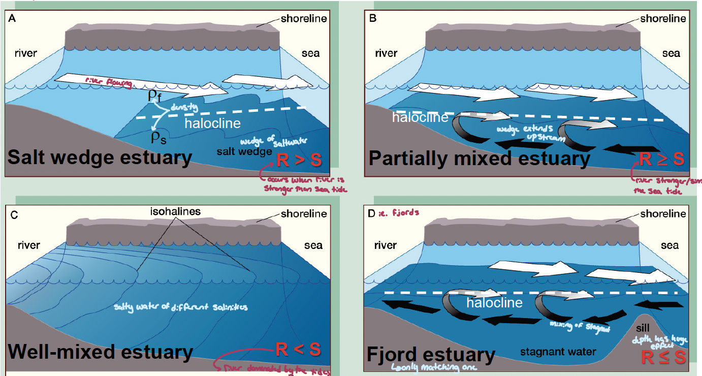
Estuarine flow is dynamic – affected by discharge & tidal cycle
for example: the Hudson River Estuary is Semidiurnal for 246 of 507 km river. Vertically averaged along-estuary salinity contours.
during Neap tides there is Strong stratification and salt wedge-like conditions, whereas during Spring tides there is Weak stratification and well-mixed conditions
what are the three guilds that use estuaries?
Marine estuarine-opportunist guild: spawn at sea, enter estuaries at certain times in lifecycle
mating
nursery
Estuarine Populations: some populations of the same species live the entire life in estuaries, others in marine environment (life cycle)
Estuarine Species: live entire life is estuaries (life cycle - exclusive)
lecture 11: marine macrophytes
what are there three main groups of macroalgae (seaweeds)? what are their secondary pigments? how are they distributed with depths (light attenuation)? what are their life cycles?
Rhodophyta: red algae, 4000 species (most diverse); harder to identify due to them being triphasic (incorrect identification of phases as different species)
secondary pigments: carot., phyco-erythrin (mostly), phyco-cyanin
storage: trash, algae, carrageenan, cellulose
distribution: dominated depths <10 m for low to high attenuation values (turbidity doesn’t matter much). prefer deep cold waters or warm shallow waters
lifecycle: 1. tetrasporophyte (2N) → sporangium (meiosis) → tetraspores (1N) → gametophyte (1N) → gametes (1N) → zygote (2N) → 7. carpospores (2N) →sporophyte…
examples: calliarthron, proplithon, phodymenia, kappaphycus
Phaeophycea: brown algae, 1500 species (1425 marine)
secondary pigments: chlorophyll c1, chlorophyll c2, carotenoids (Fuxoxanthin)
storage: laminarin and oil, cellulose and alginate
distribution: more efficient at harvesting light across the spectrum at low attenuation (< 0.2/m) when depths > 10 m (deep but only in clear water. live in shallow, cool waters
lifecycle: heteromorphic, gamete release is triggered by low DIC (calm waters); 1. sporophyte (2N) → [gametophyte stage is part of the sporophyte plant] sporangium (meiosis) →
spore (1N)(no spores)→ gametophyte (1N) → gametes (1N) → 5. zygote (2N) → sporophyte…examples: sargassum, fucus, kelps, alaria, postelsia, pelvetia, macrocystis
Chlorophyta: green algae, 7000 species (700 marine)
secondary pigments: chlorophyll b, carotenoids (same as land plants)
storage: starch, cellulose
distribution: made best use of the available light at higher attenuation values (> 0.2/m) & depths > 10 m (like water that is not as clear)
lifecycle: isomorphic (haploid and tippled stages look the same); 1. sporophyte (2N) → sporangium (meiosis) → spore (1N) → gametophyte (1N) → gametes (1N) → 6. zygote (2N) → sporophyte…
examples: halimedia, proliferation, ulva lactuca, penicillus (CaCO3 in stem), codium, caulerpa, bryopsis
![<ol><li><p>Rhodophyta: red algae, 4000 species (most diverse); harder to identify due to them being triphasic (incorrect identification of phases as different species)</p><ul><li><p>secondary pigments: <span style="line-height: normal;">carot., phyco-erythrin (mostly), phyco-cyanin</span></p></li><li><p><span style="line-height: normal;">storage: trash, algae, carrageenan, cellulose</span></p></li><li><p><span style="line-height: normal;">distribution: </span>dominated depths <10 m for low to high attenuation values (turbidity doesn’t matter much). prefer deep cold waters or warm shallow waters</p></li><li><p>lifecycle: <strong>1</strong>. tetrasporophyte (2N) → sporangium (meiosis) → tetraspores (1N) → gametophyte (1N) → gametes (1N) → zygote (2N) → <strong>7</strong>. carpospores (2N) →sporophyte…</p></li><li><p>examples: calliarthron, proplithon, phodymenia, <strong>kappaphycus</strong></p></li></ul></li><li><p>Phaeophycea: brown algae, 1500 species (1425 marine)</p><ul><li><p>secondary pigments: chlorophyll <em>c</em><span style="line-height: normal;"><em>1</em></span>, chlorophyll <em>c</em><span style="line-height: normal;"><em>2</em></span><em>, </em><span style="line-height: normal;">carotenoids (Fuxoxanthin) </span></p></li><li><p><span style="line-height: normal;">storage: laminarin and oil, cellulose and alginate</span></p></li><li><p><span style="line-height: normal;">distribution: </span>more efficient at harvesting light across the spectrum at low attenuation <span style="line-height: normal;">(< </span>0.2/m) when depths > 10 m (deep but only in clear water. live in shallow, cool waters</p></li><li><p>lifecycle: heteromorphic, gamete release is triggered by low DIC (calm waters); <strong>1</strong>. sporophyte (2N) → [gametophyte stage is part of the sporophyte plant] sporangium (meiosis) → <s>spore (1N)</s> (no spores)→ gametophyte (1N) → gametes (1N) → <strong>5</strong>. zygote (2N) → sporophyte…</p></li><li><p>examples: sargassum, fucus, kelps, alaria, <strong>postelsia, </strong>pelvetia, macrocystis</p></li></ul></li><li><p>Chlorophyta: green algae, 7000 species (700 marine)</p><ul><li><p>secondary pigments: chlorophyll <em>b</em>, carotenoids (same as land plants)</p></li><li><p>storage: starch, cellulose</p></li><li><p><span style="line-height: normal;">distribution: </span>made best use of the available light at higher attenuation <span style="line-height: normal;">values (> 0.2/</span>m) & depths > 10 m (like water that is not as clear)</p></li><li><p>lifecycle: isomorphic (haploid and tippled stages look the same); <strong>1.</strong> sporophyte (2N) → sporangium (meiosis) → spore (1N) → gametophyte (1N) → gametes (1N) → <strong>6</strong>. zygote (2N) → sporophyte…</p></li><li><p>examples: halimedia, proliferation, ulva lactuca, penicillus (CaCO3 in stem), codium, caulerpa, bryopsis</p></li></ul></li></ol><p></p>](https://assets.knowt.com/user-attachments/b4f27600-b460-4515-8a81-56a66b5692b2.png)
what are the two generations of seeweed lifecycle?
gametophyte: haploid, beast gametes
sporophyte: diplod, bears spores
what seaweeds are used in economic products?
Some are source of food (sushi), industrial materials (iodine)
Other algae are commercially important because of extracts based largely on phycocolloids (chemical categorization of stuff in cell walls) in their cell walls:
Algin(ate) (Phaeophyta) is used as an emulsifier in dairy products such as ice cream and cheese
Carrageenan (Rhodophyta) is used a thickening agent in dairy products such as yogurt, milkshakes, etc.
Agar (Rhodophyta) is used to culture microbes in the health care industry, as a thickener in foods, as a filler in pharmaceuticals and cosmetics, and to protect canned meats (gel around the can)
what are seagrasses?
secondary aquatic organisms, 60 specie in temperate and tropical locations, aquatic monocots, Nutrient uptake via water (not sediment), Boundary layer (δ) = resistance (no stomates)
seagrasses “capture” bacteria, leading to a 50% reduction in the ceontratriation of enteric bacteria (potentially disease causing as well as reductions in disease levels in corals
examples: eelgrasee (nost videly distributed)
what are salt marshes and mangrove forests?
Depositional zones that develop in coasts with little wave action. Ecological analogues (halophytes) in temperate (salt marsh) vs. tropical (mangrove) regions
salt marsh: occur in temperate latitudes where coastlines are protected from wave action. stabilize sediments, nutrient cycling & uptake, habitat, food crab/terrestrial animals, detritus
Salt marsh structure is determined by tides and salinity
Seaward edge: tall, deep green Spartina alterniflora (Carex, BC) that has a high tolerance for salinity
High marsh: less saline environment, stands at the level of mean high water and supports Spartina patens (shorter, yellow form), Salicornia, Limonium, etc.
mangroves: cover 60 - 75% tropical coastlines (stabilize sediment, epiphytes & canopy habitat, nursery/refuge, fruit eaten, detritus). develop where wave action is absent, sediments accumulate, and muds are anoxic
Dominated by mangrove plants (Rhizophora, Avicennia) but includes 54 tree, shrub, palm & fern sp (16 families)
Mangroves range from short forms to large-sized trees and all have shallow, widely spreading roots
Rhizophora: prop roots (support) & pneumatophores (gas exchange), slow tidal waters, which allows sediments to deposit and accumulate
lecture 12: Benthic rocky substrates