soils
1/25
There's no tags or description
Looks like no tags are added yet.
Name | Mastery | Learn | Test | Matching | Spaced | Call with Kai |
|---|
No analytics yet
Send a link to your students to track their progress
26 Terms
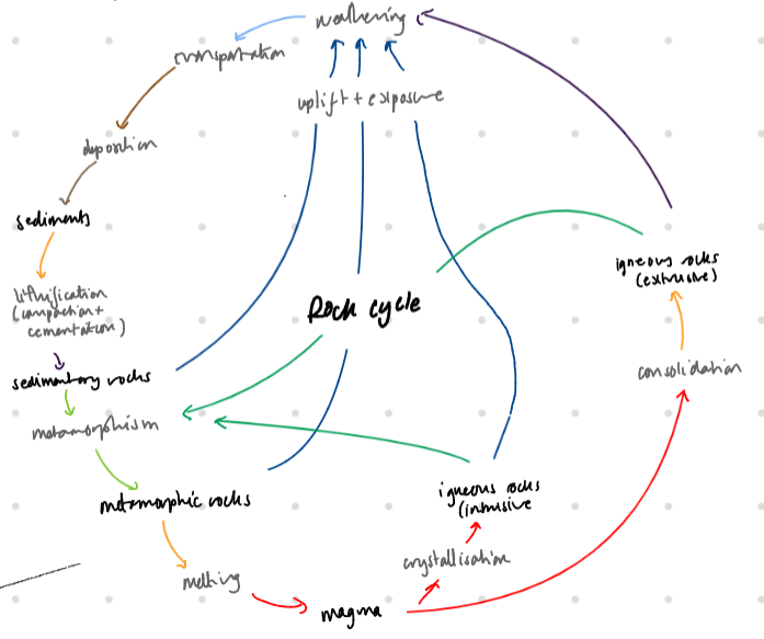
rock cycle
initially all rocks were igneous (cooled + solidified magma) → either intrusive (plutonic where magma cools before reaching the surface) or extrusive (volcanic where magma is ejected onto the surface)
metamorphic rocks
are rocks that are altered by temperature or pressure
rocks that have been uplifted to surface may be degraded by:
erosion/transport - removing rock over time by water, ice or wind + transporting the sediment elsewhere as SEDIMENTARY rock → type of sedimentary rock depends on medium of transport (water wind or ice)
weathering - process of degradation due to biological, mechanical + chemical processes without removing it → more vulnerable to erosion
geological timescale
UK geology is of diverse periods BUT we are most interested in the QUATERNARY period (last 10,000 years) → last 0.04% of the age of the earth + the holocene (the last 10000 years since the last ice age)
geotechnical engineering
engineering technology - origins of rocks + soils, geological history + hazards associated with them
soil + rock mechanics - behaviour of rocks + soils - the strength, stiffness, compressability + permeability
geotechnical design + construction - foundations, retaining walls + slopes
plate tectonics
due to continental drift, the climate over a given area changes significantly over time = different rocks/soils e.g. desert soils found in england - formed during permian + triassic period.g
global plate tectonic movement since jurassic
europe splits from north america - africa moves from south america
mid-atlantic-rift opens up at 30mm/year
alpine orogeny (mountain building period - 60 - 10 million years ago) pushes up the Alps as italy collides with europe + himalayas as india collides with asia
previous orogenies e.g. Variscan (280-320 million years ago) + Caledonian (490 - 390 million years ago) → older mountain ranges are now severely eroded
unconformities (missing piece from geological succession)
caused by deposition halting for a period of time or some strata being eroded before new strata is deposited (MORE LIKELY)
may be recognised by a change of dip of strata + new strata filling up an old valley
joints
fractures in rock/soil which have not moved - FAULTS HAVE MOVED, joints typically weaken rock + make more permeable, + occurs in sets with similar orientation + dips
main types of joints:
tectonic - typically steep + continue to have great depth e.g. lamorna cove - cornwall
stress relief - typically shallow + parallel to ground surface → formed by release of stress near surface
sedimentary - bedding planes + tectonic joints e.g. old red sandstone, uk
cooling - joints formed by the cooling of igneous rock, typically columnar e.g. sai kung
rock cycle continued
all three rock types provide source material for weathering/deposition/erosion + creation of new sedimentary rocks OR new melted rock to form magma/metamorphic rock
weathering + deposition/erosion tends to reduce rocks to soils + the process of soils → rocks under high pressure at depth = LITHIFICATION
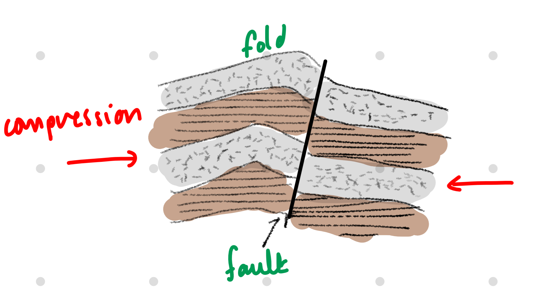
folds + faults
result of strata being subjected to tectonic forces - compression shear + extension
folds form in compression when behaviour is tactile - weaker deposits or at high stress levels (near surface)
faults form when behaviour is brittle e.g. in extension or in compression in stronger deposits OR at lower stress levels + movement tends to be stick-slip earthquakes
may occur in a stratum concurrently or at different times in history
folds are usually tectonic in origin + form in compressive environments
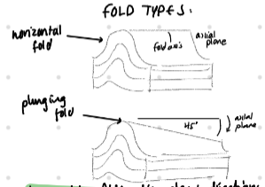
fold types
there is also anticlines ͡ with older rocks in the centre + synclines ‿ with newer rocks in the centre → both typically dont correspond to hills + valleys as they are usually eroded after formation - hills + valleys correspond to stronger + neater rocks within structures
often what is seen in the field is not the main syncline/anticline but small ripples within the large geological structure.
in upright folds, dip angles + directions tell you which side of the fold you’re on BUT OVERTURNED folds dip + dip directions in the 2 limbs of fold may be similar
rock cycle
bedding surfaces in sedimentary rocks
simple geological deposition would be on a flat plane, so successive sediments build up vertically with the newest on top
bedding planes may show up as succession/alteration of the deposition of different materials
if inclined (due to folding) → they are DIPPING e.g. mercia mindstone, UK
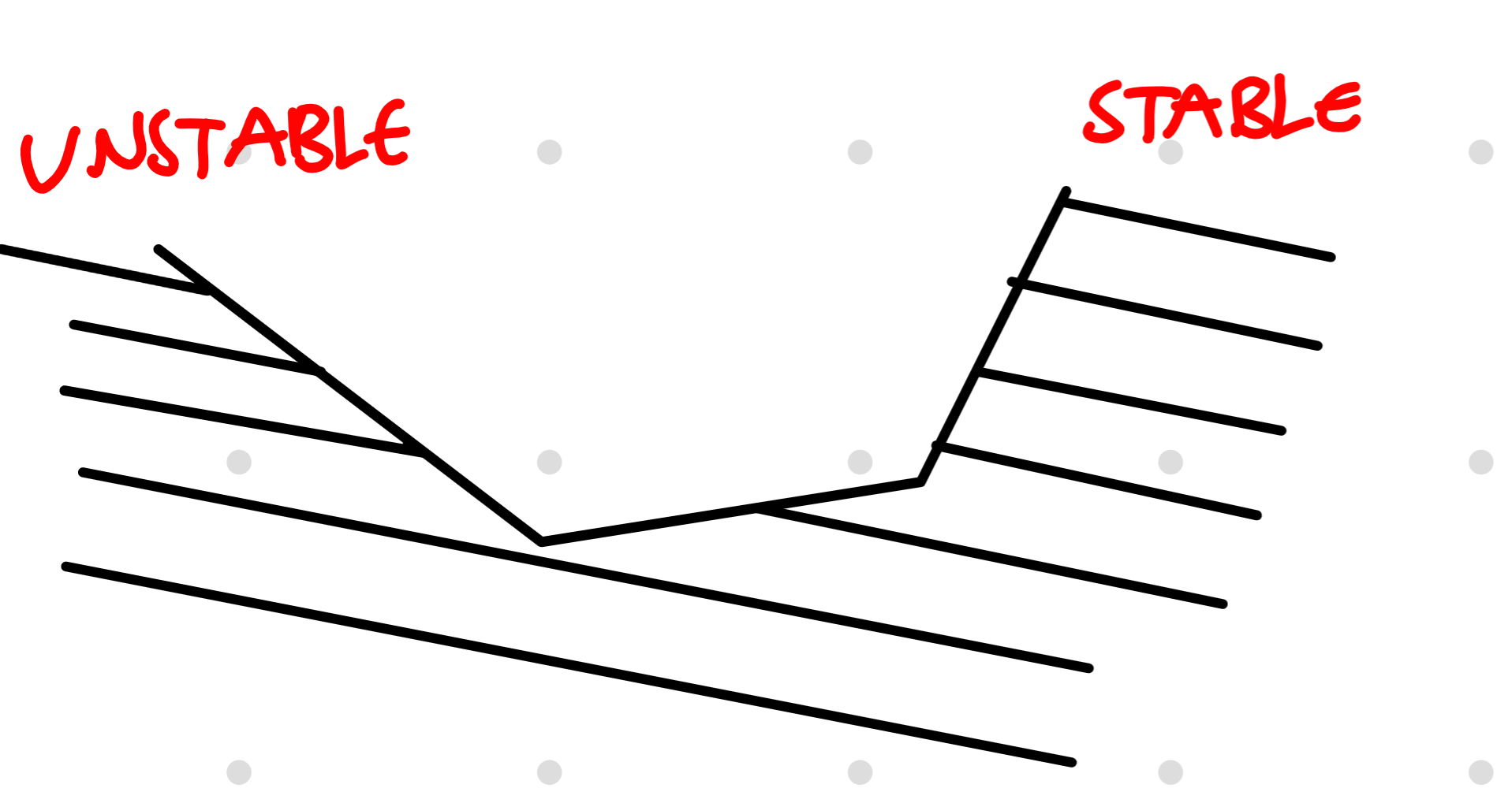
bedding planes
often areas of weakness → influence engineering design STRONGLY + orientation of drip of bedding planes strongly affects stability of slopes
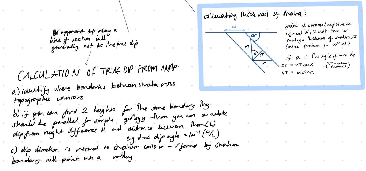
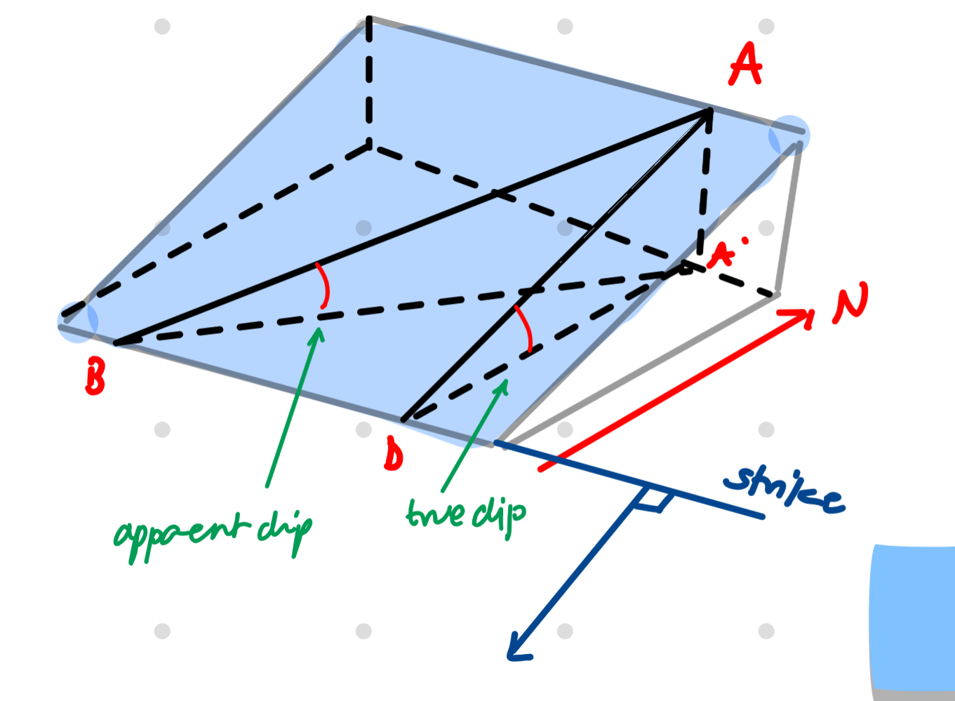
quantifying strata’s dip
orientation of dip (relative to north) quantified with the strike (normal to true dip - defining a horizontal surface within stratum) or dip direction (down true dip)
we similarly quantify the geometry of other planar geological features
what you see in a cliff face may not be the true dip → APPARENT DIP so need a bedding surface to measure the true dip
fault types
thrust fault - reverse fault w/ a shallow dip
fault gorge - ground rock within a fault zone
fault breccia - larger, angular pieces of rock remain
fault scarp - makes fault obvious near surface - but are usually eroded away
plasticity index
PI = liquid limit - plastic limit
indicates range of water contents over which soil usually found and how plastic (mouldable) and “sticky” soil will feel
darcy’s law
Q (m3/s) = A(m²) x k(m/s) x (change in h)/L
flow = cross-sectional area x permeability x hydraulic gradient (i)
piping occurs when
gradient > hydraulic gradient
effective stress
dry soil: total force/area
saturated soil:
normal effective stress σ’ = total of normal forces/area
shear stress τ = total of tangent forces/area
total normal effective stress σ = σ’ + u(10*z)
total shear stress τ = τ’
clays v sands
clay’s mechanics are dominated by surface forces
clay’s particle + void size is smaller
clays can be deposited at high void ratios = almost a liquid
soils - flow of water through soils is slow
sands cannot be deposited at high void ratios due to the lack of electrostatic forces
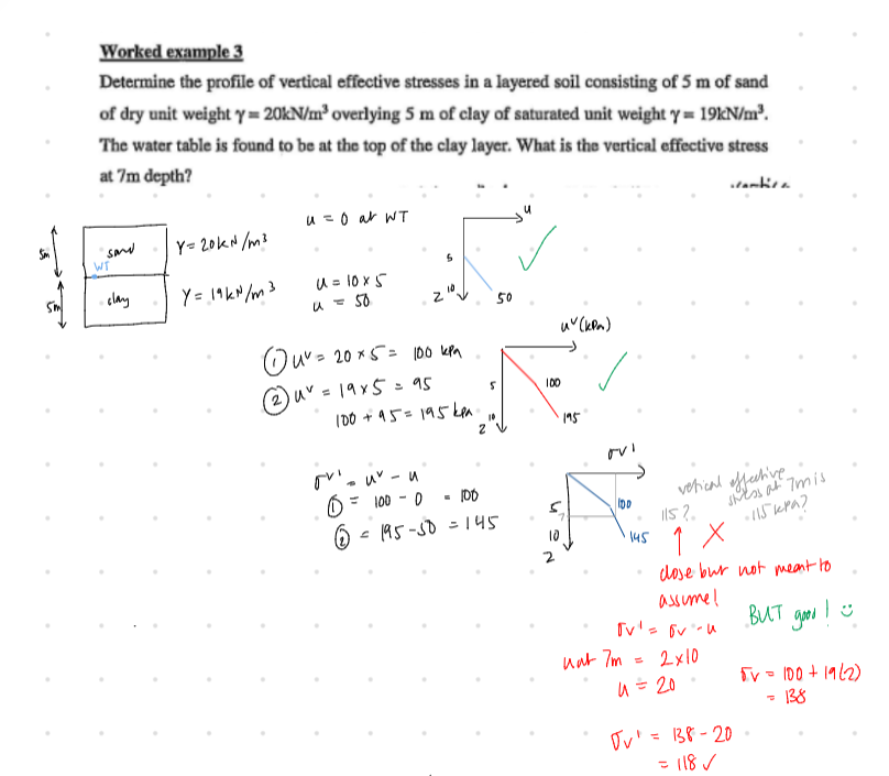
vertical effective stress example q
FLOWNETS
total head = pressure head + elevation head (observed value)
total head = H - H/total number of drops * drops to point
pore water pressure = pressure head * 9.81
particle size distribution
SCALE - y axis = % finer than 0-100, x axis = particle size in mm GO FROM 0.001 - 100 if u can
add total of sample mass, then cumulatively calculate % retained - do 100% minus this for % finer than, for 0 values do 100%
uniformity coefficient = D60/D10, a smaller value = a poorly graded soil (more consistent), larger value → well-graded
seems important