Physical geo
1/105
There's no tags or description
Looks like no tags are added yet.
Name | Mastery | Learn | Test | Matching | Spaced | Call with Kai |
|---|
No analytics yet
Send a link to your students to track their progress
106 Terms
What's the continental drift?
A theory made in 1915 by Alfred Wegener, he stated that he believed continents move. He said 300 million years ago, the continenets formed together into a supercontinent called Pangea and 200 million years ago, they started to drift apart
What are the 4 proofs Alfred Wegener had?
Jigsaw fit
Fossils
Mountains
Ice sheets
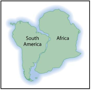
What's the first proof as to why Alfred believed his continental theory? (Jigsaw fit)
Jigsaw fit: South America and Africa seemed to fit together like a jigsaw puzzle, he thought its likely because they were connected at one point
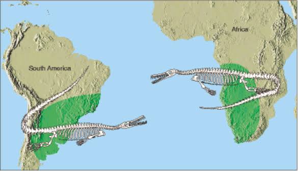
What's the second proof as to why Alfred believed his continental theory? (Fossils)
Fossils: a variety of plants and animals were found on both South America and Africa and he believed it was impossible they traveled across the Atlantic ocean.
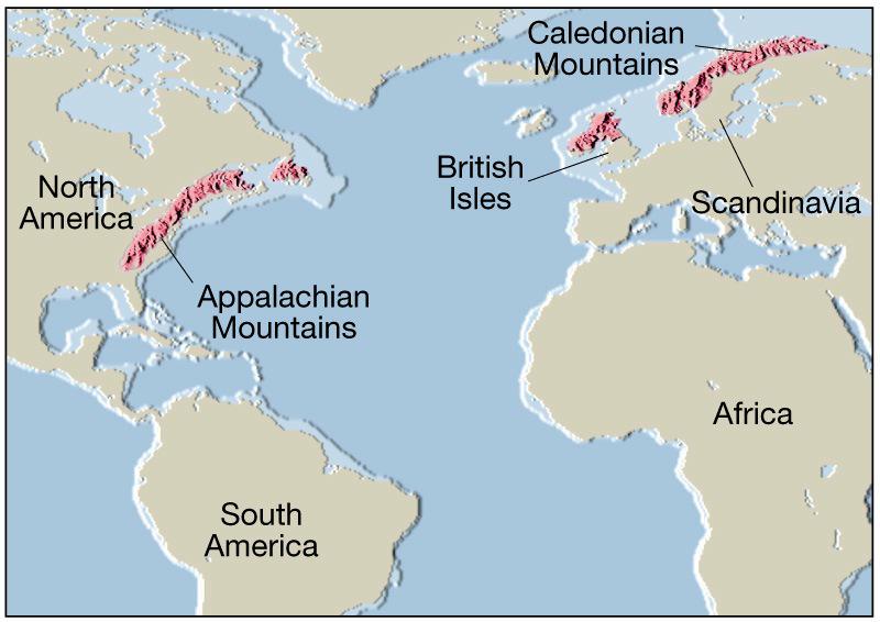
What's the third proof as to why Alfred believed his continental theory? (Mountains)
Mountains on both sides of the Atlantic ocean were the same age and same structure and material.
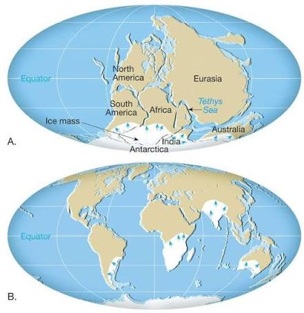
What's the fourth proof as to why Alfred believed his continental theory? (Ice sheets)
Africa, Australia, South America and india showed evidence of being covered by ice sheets about 250 million years ago. Wegener believed that that such warm places would be covered by ice only if they were closer it the south pole (cold area)
Why didn't scientists believe Alfred Wegener's theory?
Wegener couldn't explain how something can be powerful enough to move continents.
Some of his logic was incorrect or too crazy to believe
What's John tuzo Wilson's theory?
In 1968, he discovered that the earth’s crust had 20 plates that move
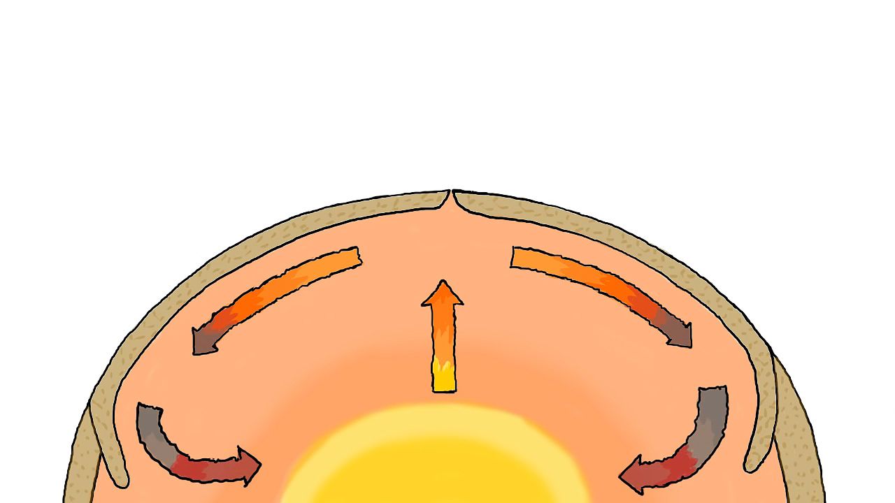
How do the earth's plates move
Convection current
What are convection currents?
Core heats up nearby rock, they lose density and rise up
Cooler rock near the earth's surface go down and the core heats them
The hot rock that rose up cool down and go back down again
The cool rocks that went down and got warmer go back up
This creates a pattern
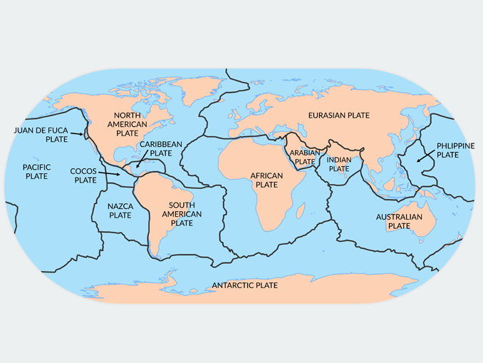
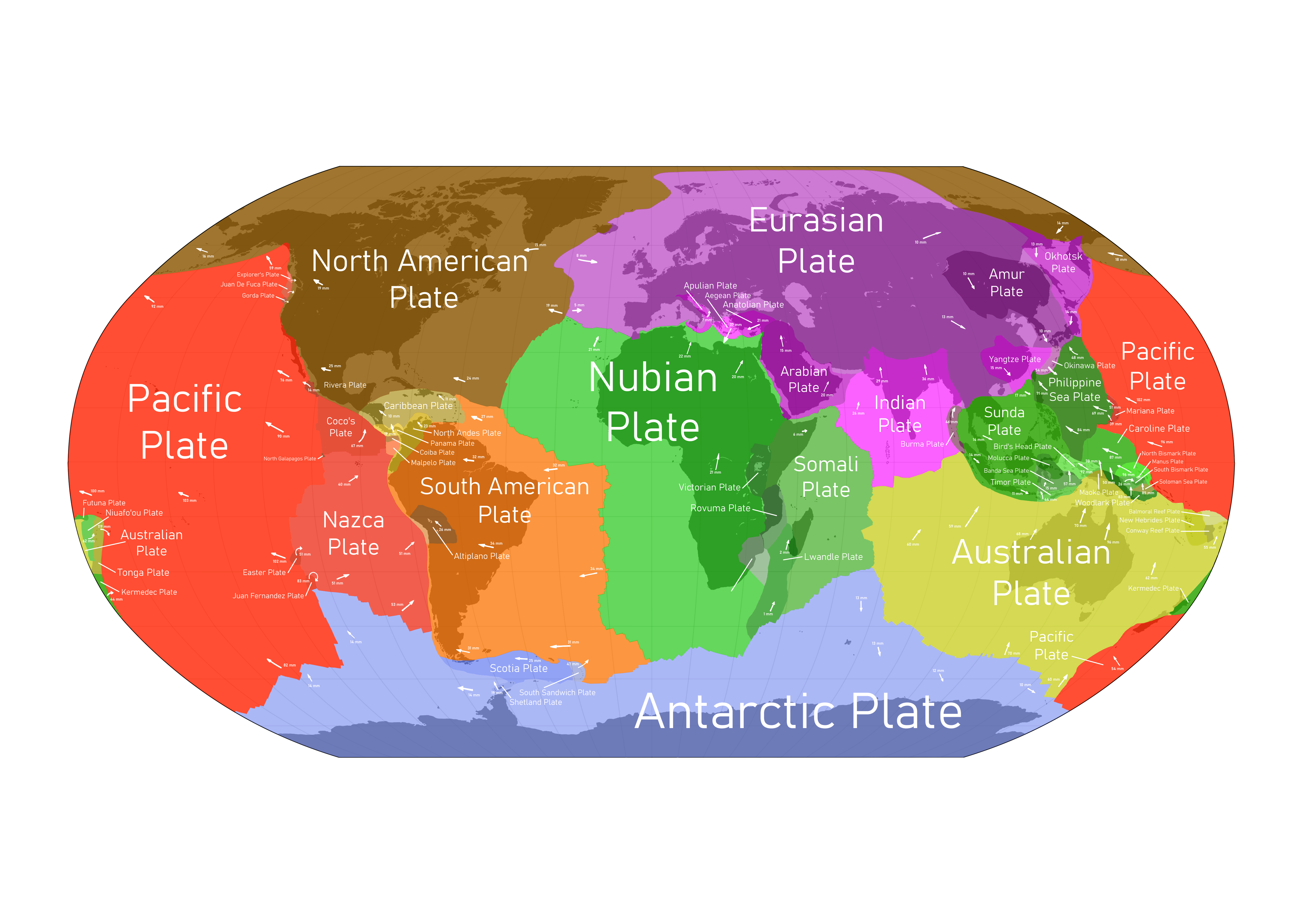
how many tectonic plates does the earth have?
20
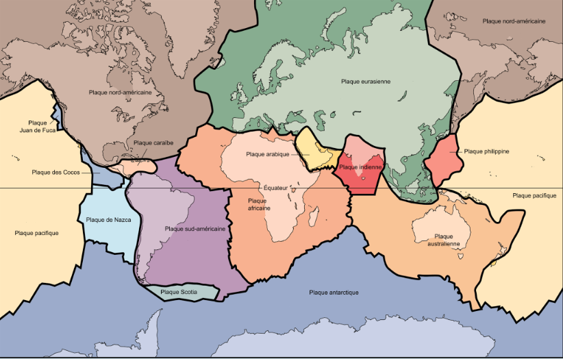
What are the seven major plates?
Pacific
North American
Eurasian
African
Antarctic
Indo-Australian
South American
What makes up the mantle?
Slow moving hot rock
What are plate boundaries?
The space (cracks) between tectonic plates where they meet each other.
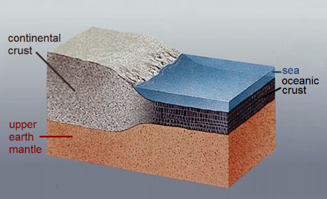
What are the 2 types of crust?
Oceanic, usually 5-10 km thick and made of very dense rock.
Continental, usually 25-70 km thick (40 km on average) and it’s made of less dense rock then oceanic.
What are the 3 types of plate boundaries?
Divergent: Move apart
Convergent: Collide together
Transform: slide past each other
What are divergent plate boundaries?
When 2 plates are separating away from each other in the opposite directions
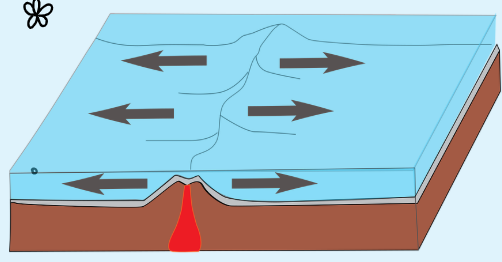
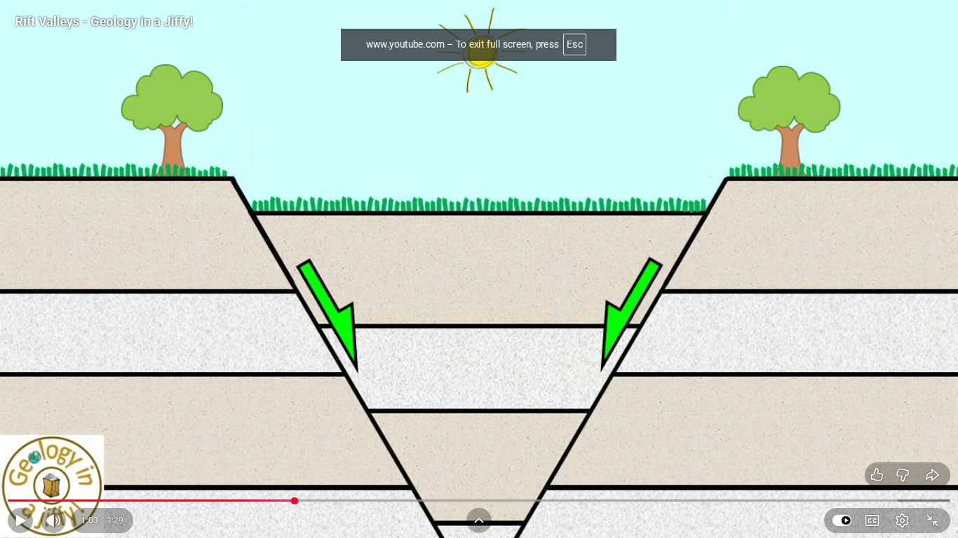
What are the two types of divergent plate boundaries?
Mid-ocean ranges
Rift valleys
What are rift valleys?
2 continental plates separate, the cracks stretch and the middle part sinks.
What are mid-ocean ridges? Ex?
oceanic plates separate
magma rises and cools underwater
magma turns into rock and and long, low mountain chains
Ex: mid-atlantic ridge
What are convergent plates?
Plates collide together (3 main types)
How do mountains form? Ex?
Continental-continental convergent plate boundaries happen. Ex: Eurasian and Indian plates collision formed himalayas mountains
How do volcanoes form?
Oceanic-Continental convergent plate boundaries happen. Oceanic plate goes underneath the continental plate (mantle) and melts which forms magma, the magma rises and causes volcanoes
How do earthquakes form?
Oceanic-Continental convergent plate boundaries happen. When the oceanic plate is going underneath the continental plate, the movement isn’t smooth and they get stuck then suddenly they break free and slip away.
What are island arcs?
Chain of islands
How do island arcs form?
Oceanic-Oceanic plate boundary collide
The denser plate goes underneath the other one (subducts)
It forms magma
Underwater volcano occurs
The magma keeps rising and turns to rock until it reaches the surface and creates an island arc
What are subduction zones? Ex?
The area when a convergent plate boundary occurs and the denser plate goes underneath (subducts) and turns to magma. Example: pacific ring of fire aorund the pacific ocean that has more volcanoes and earthquakes
What are transform plate boundaries?
2 plates slide past each other
What are volcanoes?
A vent where magma, volcanic ash and harmful gases are released deep from the earth to the surface
Where are volcanoes located?
Convergent plate boundaries
Divergent plate boundaries
Hotspots
What are hotspot volcanoes?
Magma inside the mantle erupt as the oceanic plate move over it and it turns into rock and multiple eruptions can make it higher until it forms an island
What are the three types of volcanoes
Active = erupting or can erupt soon
Dormant = sleeping, might wake up
Extinct = dead
Whats magma
Underground melted rock
What is lava
Magma that reached the earth’s surface
What is volcanic ash?
A mixture of rock, minerals and glass particles that come from a volcano eruption
What are some of the gases that erupt from a volcano
Harmful acids such as hydrogen halides. Water vapour and harmful substances such as sulphur dioxide, hydrogen sulphide and carbon dioxide.
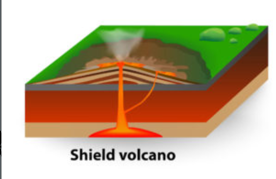
What are shield volcanoes?
Fast moving lava that erupts in all directions a lot. Creates many of the major island chains in the ocean
What are strato volcanoes?
Slower moving thick lava that erupts from a steep slope. usually found in convergent plate boundaries
What are earthquakes
The sudden release of pressure in the earth’s crust
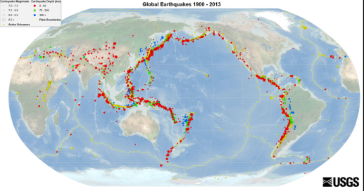
Where do the most extreme earthquakes occur?
Convergent boundaries
What are seismographs
Tools all around the world used to detect how strong and where earthquakes are
How do seismographs work?
Shaking of the ground is measured and recorded by sensitive equipment
What’s the moment magnitude scale
A scale that shows how powerful an earthquake is. Each number is 10 times more powerful than the previous number. Ex: value 1= strength 1. value 2= strength 10. value 3= strength 100
What can an 8.8 earthquake do
Kill people, destroy houses, tsunamis and landslides (hill or mountain collapses)
How could a city prepare for an earthquake/volcanic eruption?
Have earthquake survival kits consisting of food and water, essential survival gear, hygiene/ health, personal items or important docs.
Warning systems to warn people
Have flexible buildings where the building moves with the earthquake instead of breaking
Why might two earthquakes of similar power cause very different amounts of damage?
Area density: If it’s an open area with less buildings and people it’ll cause less damage compared to a packed area with people and buildings
How prepared an area is
Signs of volcanoes
small earthquake
steam or smoke coming out of vents
increased heat around volcanoes
Gas coming out of vent with a smell of sulfur or rotten eggs
What are the 4 eras? Period of time
Precambrian (4600Ma-570Ma)
Paleozoic (570Ma-245Ma)
Mesozoic (245Ma- 66Ma)
Cenozoic (66-present)
What are the 3 main things that happened in the precambrian era?
Formation of major land masses like Canadian, Brazilian, Australian and african shields
first single cell
first multi cell
What are the 3 main things that happened in the Paleozoic era?
First plant and animal (amphibians and fish)
Large parts of North America covered by shallow seas
Appalachian mountains
What are the 3 main things that happened in the Mesozoic era?
Dinosaurs, mammals and birds
Shallow seas appeared and disappeared in North america
Rocky mountains. ex: Innuitian mountains in Canada
What are the 3 main things that happened in the Cenozoic era?
Ice sheets cover large parts of North america
Modern continents
Human beings development
How old is the earth?
4600 Million years = 4.6 billion years
What are climate graphs?
A graph that summarizes climate info about an area. The most common is average monthly temp and total monthly precipitation.
How does average monthly temp look like on a climate graphs?
Red line of connected dots placed in the middle of columns
How does total monthly precipitation look like on a climate graphs?
Blue side by side bars that fill the entire column
Why are climate graphs helpful?
It can help tell us if an area is maritime or continental
Amount of precipitation to be considered maritime or continental (full year worth of precipitation)
Greater than 1000mm = maritime
Less than 1000mm = continental
Difference of lowest and highest temperature to be considered maritime or continental?
Less than 25°C = maritime
Greater than 25°C = continental
Season Distribution of Precipitation (season that contains the most precipitation) to be considered maritime or continental?
Winter months Oct. - Mar. = maritime (u-shape)
Summer months Apr. - Sep. = continental (mountain shape)
Effects of volcanoes?
Tsunamis
Landslides
Lava destroys nearby areas and could hurt humans (buildidngs, roads, etc)
Volcanic ash collapses house roofs and cause air pollution
Where are rocks found?
Ocean
earth’s surface
under soil
What are the 3 types of rocks?
Igneous
Sedimentary
Metamorphic
How do igneous rocks form?
Magma or lava cools
What are the 2 types of igneous rocks? Ex?
Intrusive: Cools slowly deep in the earth (Granite)
Extrusive: Cools fast on the earth’s surface (Dacite)
How can you tell the difference between intrusive and extrusive rocks?
Intrusive: Cools slowly so crystals have time to grow
Extrusive: Cools fast so crystals don’t have time to form
What are sedimentary rocks? Ex?
Rocks that form after millions of years of sediments compaction and cementation. Ex: Sandstone
How do sedimentary rocks form?
Compaction: Sediments become tightly packed from the weight of top layers
Cetementations: Mineral dissolved in water fills up the gaps between the layers of sediments and when it evaporates, the mineral stays behind and acts like cement and the whole thing becomes hard.
What are metamorphic rocks?
Other rocks that change their appearance
How do metamorphic rocks form? Ex?
When rocks are buried under other rocks, the pressure and heat change the appearance of the them. Ex: Slate
What’s weathering?
Breaking of rocks (sediments) through chemical or physical processes
Physical change: changes form
Chemical change: changes composition
What’s erosion?
Sediments moving
What’s deposition?
Dropping of sediments
Explain frost wedging
Water seeps into rocks cracks and when temperature drops, the water freezes, turns into ice and becomes 9% larger. The ice acts as a wedge hammered into the cracks of the rock and keeps adding pressure until the rock splits apart.
Explain exfoliation (physical force that causes weathering)
Deep underground rocks have intense pressure due to the dirt and other rock sitting on top of it. Erosion washes away those top layers of rock and that deep underground rock is finally free to move. The underground rocks are hard and brittle so the surface cracks into large flat layers or curved sheets that slide off
What’s carbonation ( chemical force that causes weathering )
rain mixes with carbon dioxide in the air and makes a weak acid called carbonic acid. When the carbonic acid hits rock, it reacts with the calcium in the rock and the rock dissolves and washes away
Explain Oxidation ( chemical force that causes weathering )
Oxidation is when oxygen reacts with minerals in rocks and it turns to iron oxide which weakens the rock and it crumbles easily.
3 examples of erosion
Water currents
Wind
Explain water currents erosion
When rocks are being moved by rain (surface runoff) and eventually reach rivers, the rivers move the rocks to the ocean and they stop moving in the ocean
Explain wind erosion
Wind picks up and moves sand, the sand chips the rock and the small chips move with the wind to dry climates
Explain gravity erosion
When rocks at a cliff get weak and become too heavy to stay up, they fall and it creates a pile at the bottom.
Explain water deposition
Water carries sediments and when it loses energy and slows down, it drops those sediments.
Explain glacial deposition
Glaciers carry sediments and drop them when they melt
Main 3 physical regions of canada
Canadian shield
Lowland
Highland
What is the Canadian shield
Big area of old worn down ancient mountains
What are lowlands
Surrounds the Canadian shield
Low elevations
What are highlands
Surrounds lowlands
High elevations
What are canada’s 7 landform regions
Innuitian mountains
Arctic and Hudson bay lowlands
Western Cordillera
Interior plains
Canadian shields
Appalachians
Great lakes-St.lawrence lowlands
What’s the oldest and largest landform region in Canada
Canadian shield
Describe the Canadian shield
contains fresh water
Made of rocks and poor soil
Used to contain many huge mountains but they eroded away
What are the 3 lowland areas? Percentage of Canadians that live there
Interior plains 17%
Great lakes-St Lawrence lowlands 60%
Hudson bay arctic lowland 0%
Describe lowlands
Canada’s best farmland area
Contains big amount of canada’s oil and gas
What are the 3 highland areas?
Western Cordillera
Innuitian mountains
Appalachian mountains
What do highlands have a lot of?
Minerals like silver, gold and copper
Parts of Western Cordillera
Rockies
Coast Mountains
Columbia mountains
Plateues + foothills (lower highland)
What are the 2 types of glaciers and where are they?
Alpine, mountains
Continental, land
Explain glaciers erosional effects
It can move a big amount of materials long distance
Canada’s result due to glaciers erosions
Soil loss
Lakes and rivers: destroyed and made in new locations
Explain glaciers depositional effects
Eroded stuff are depsosited by moving ice or meltwater
Result due to glaciers depositions
Meltwater has sorted rocks and deposits heavier rocks first
Moving ice has mixed and unsorted rocks of different sizes