13-16 lecture slides
1/50
There's no tags or description
Looks like no tags are added yet.
Name | Mastery | Learn | Test | Matching | Spaced | Call with Kai |
|---|
No analytics yet
Send a link to your students to track their progress
51 Terms
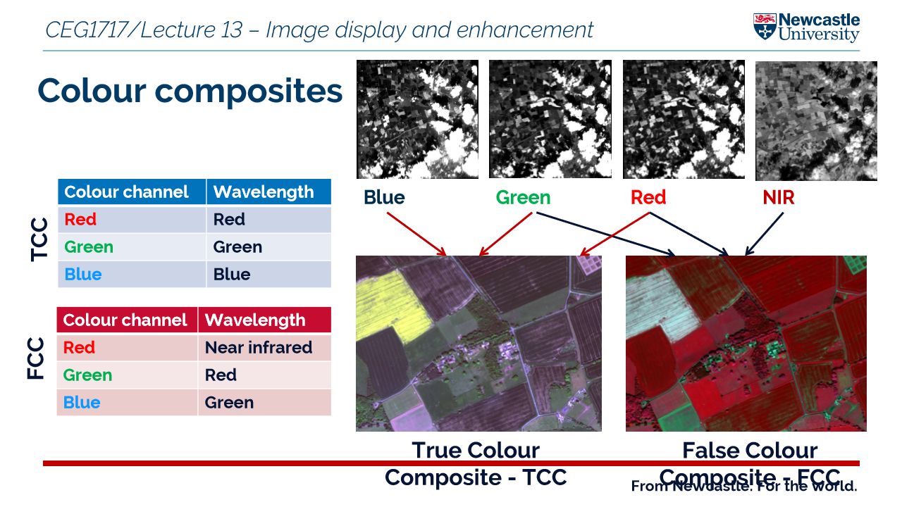
what is a false colour composite?
displays non visible wavelengths like IR - the colours do not represent what the human eye sees
what is a spectral signature?
The unique reflectance or emittance pattern of an object across different wavelengths of the electromagnetic spectrum.
think of it as a fingerprint that helps satellites identify materials on earth
However there are limitations:
illumination conditions such as cloud cover
time of day can alter reflectance
season
why is spectral signature important?
broad leaf and needle leaf both have the same visible region however have different characteristics in the NIR band!
classify land cover
detect vegetation types
monitor water bodies
distinguish snow from clouds
assess soil moisture
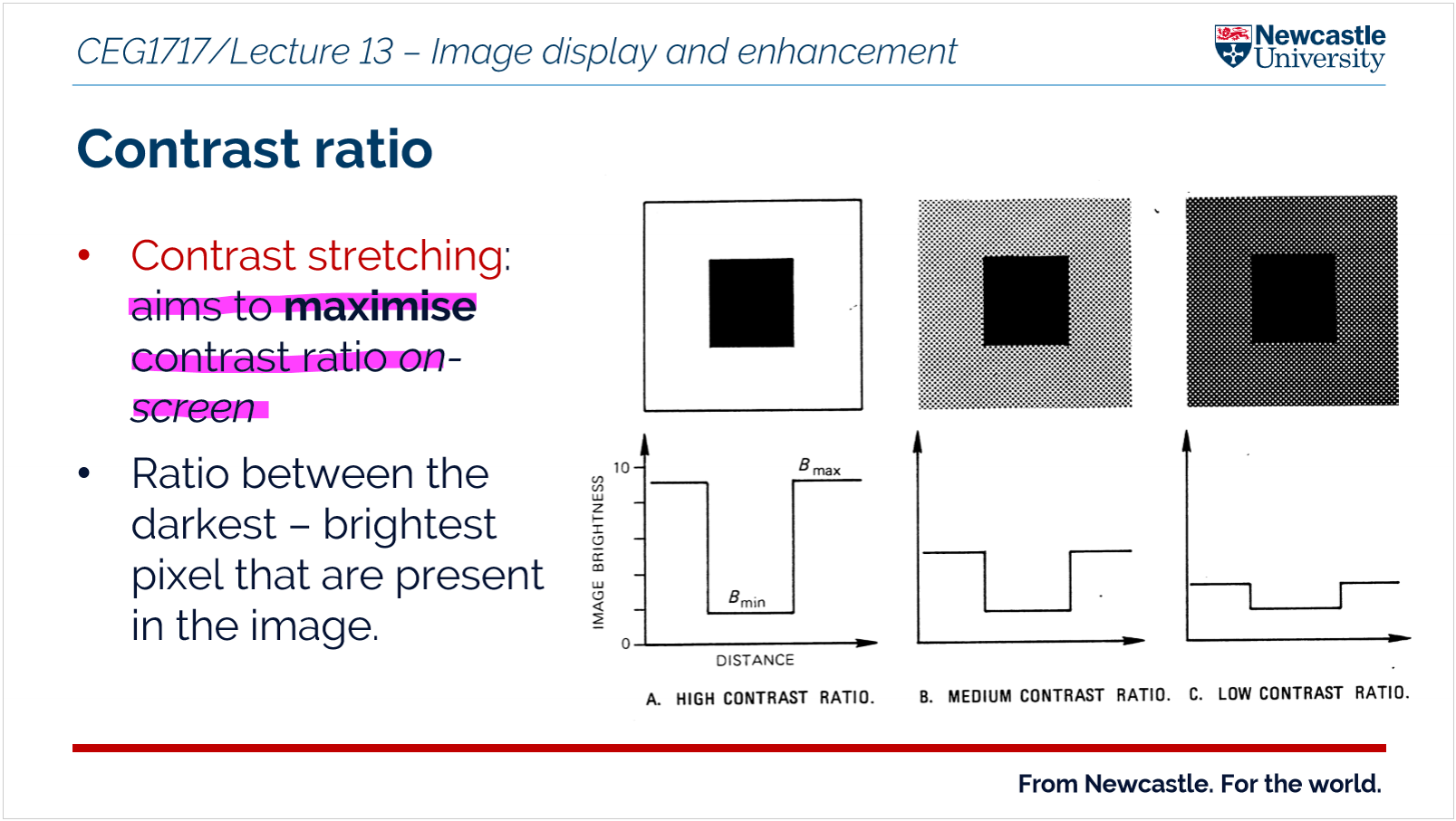
what are the reasons for applying contrast stretching to an image?
An image enhancement technique used in remote sensing to improve the visibility of features in a satellite image
Works by exbanding the range of pixel brightness values so that differences between dark and bright areas become clearer
Make features clearer
contrast manipulations involve changing the range of values in an image in order to increase contrast
Main principles:
original pixel values are unchanged - does not change the original information
what are some of the common methods of contrast stretching?
Linear contrast stretch = Exbands the range of pixel brightness values linearly so that the image uses the full display range = this improves the visibility of features in the image
non linear = an image enhancement technique in which pixel values are redistributed using a non-linear transformation so that certain ranges of brightness are expanded more than others, improving the visibility of specific features in a digital image.
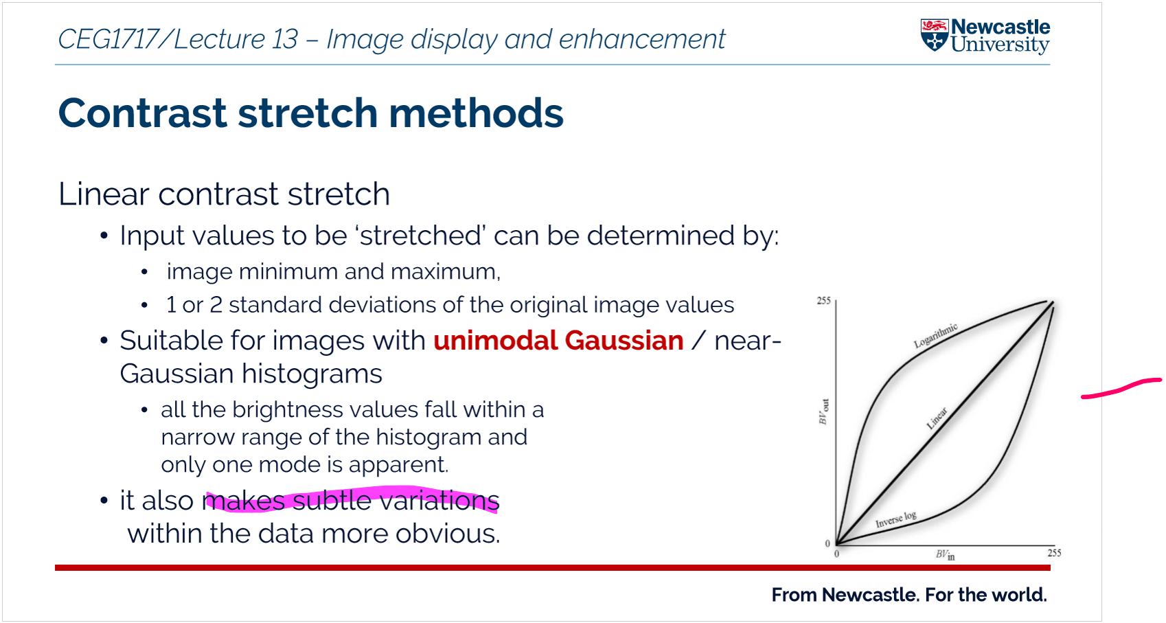
Linear contrast advantages and disadvantages
A
easy to apply in software
low computational cost
D
may not improve low contrast regionals well - it cannot highlight subtle differences
Non linear advantages and disadvantages
A
enhances specific features and subtle details
D
more computational complex
may alter the proportional relationship between pixel values, meaning the original radiance/reflectance relationships are not preserved.
selective enhancement - Certain intensity ranges are enhanced more than others, which can over-emphasise some features while suppressing others.
what is the purpose of visual enhancements such as density slicing?
to improve the quality and information content of original data before further processing
density slicing is used to used to improve the interpretability of images by grouping continuous pixel values into discrete classes, making specific features easier to identify and analyse.
what is image enhancement?
process of improving the visual appearance or interpretability of a digital image to make features easier to identify and analyse.
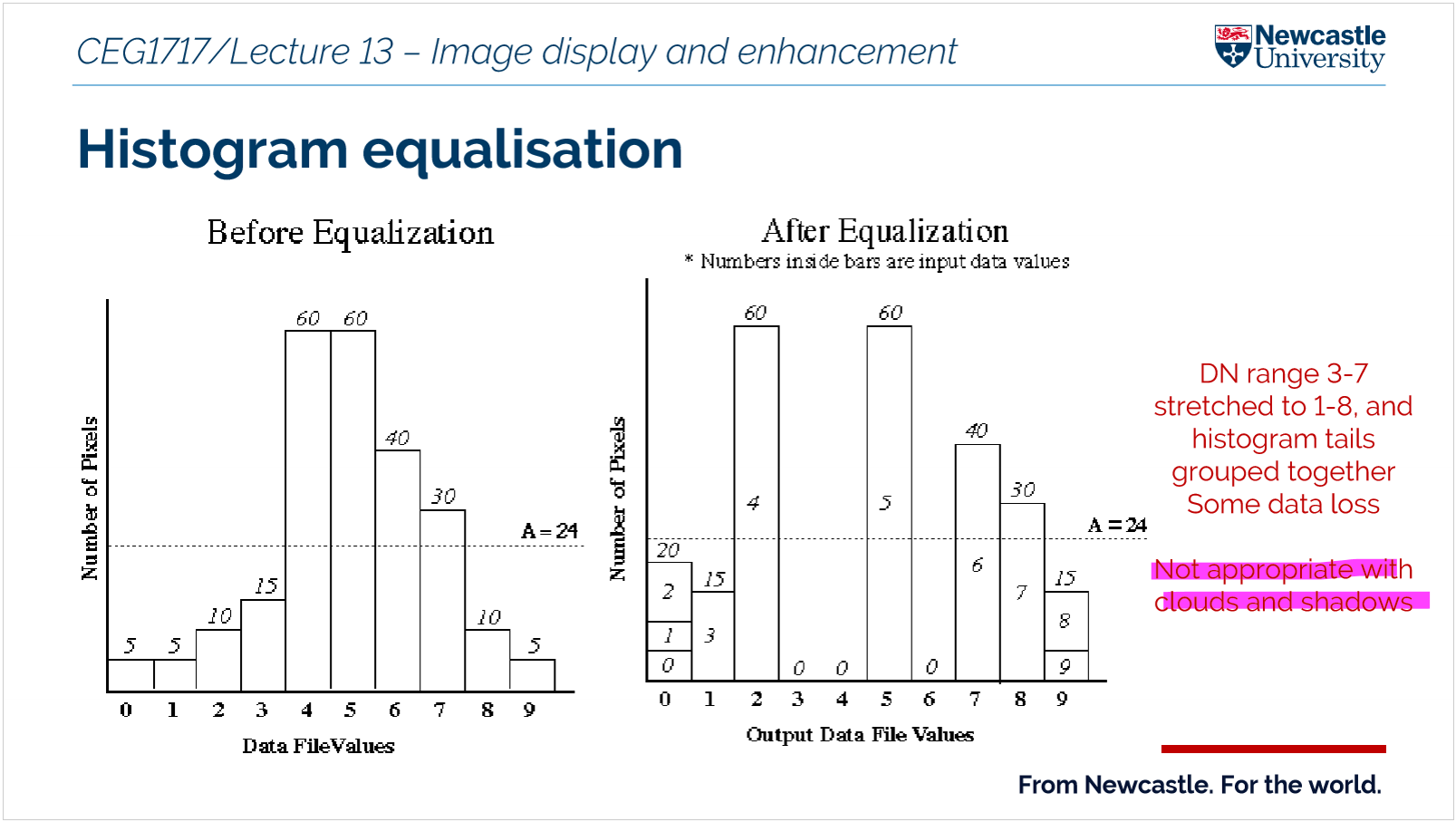
what is histogram equalisation?
an image enhancement technique that redistributes pixel intensity values so that they are spread more evenly across the available range, increasing contrast in an image.
what is density slicing?
all pixels within a slice
Way to turn continuous data into categories
The raster’s values (like elevation, temperature, or vegetation) are divided into ranges called “slices.”
Each slice is given a different color or shade.
This makes it easy to see patterns on the map.
It is called a crude classification map
an example:
0- 0.2 barren land
0.2-0.5 sparse vegetation
Describe the stages of image pre processing?
DN (raw image)
Data Clean (defects removed)
at sensor radiance
TOA (at sensor reflectance)
BOA (at surface reflectance)
Geo (geometric correction / orthorectification)
Enhance (image processing)
Products (maps, indices, classification)
1. data cleaning
radiometric correction - change the brightness
atmospheric correction
geometric correction
image enhancement
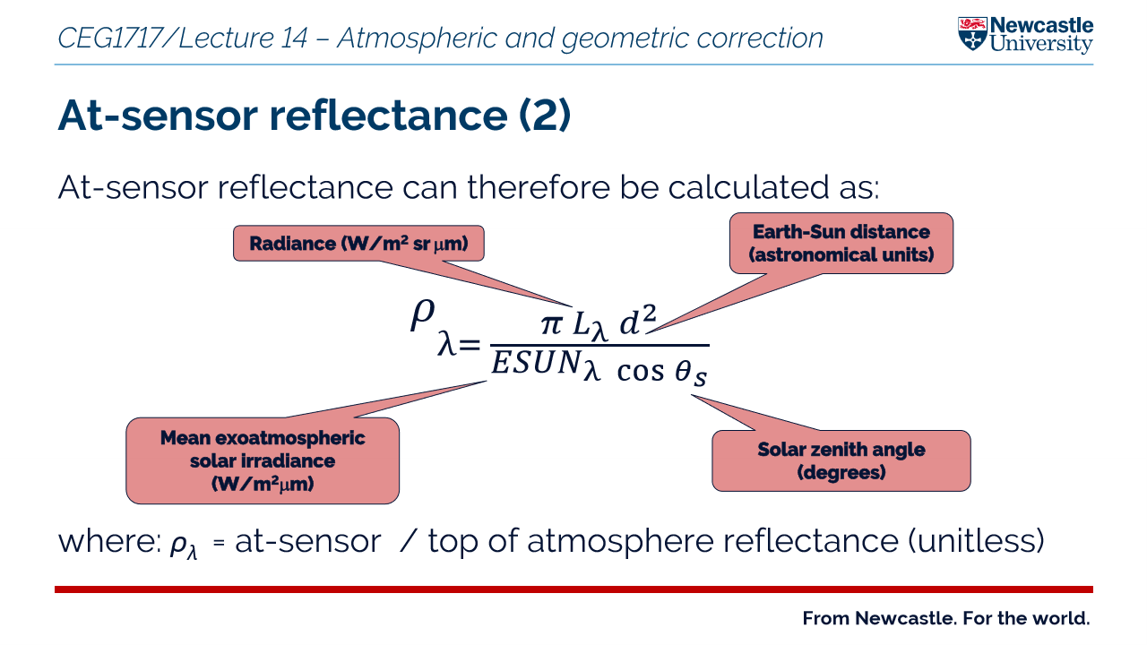
at sensor vs at sensor radiance vs at sensor reflectance
At sensor = radiance or reflectance is the raw measurement made by the sensor including atmospheric effects
At sensor radiance = refers to the measurement of the intensity of electromagnetic radiation emitted or reflected from a surface by a sensor.
At sensor reflectance = the measurement we usually want - the reflectance of the ground surface with any atmospheric influence removed
what does offset mean from atmospheric effects?
means that contrast is reduced - there is a less difference between the lightest and darkest parts of an image
what is atmospheric correction?
Conversion of imagery to at-surface (BOA) reflectance
Atmospheric corrections correct for the effects of the atmosphere on the data collected by satellites or airborne sensors, which can include scattering, absorption, and emission of electromagnetic radiation. These corrections are necessary to remove or minimize the atmospheric effects, allowing for the estimation of the actual reflectance of the Earth's surface.
Why is atmospheric correction important?
Extracts true surface properties (e.g. NDVI)
Enables time-series comparison
Allows multi-sensor comparison
Key point - can sharpen images improve spatial definition of objects/edges
When is atmospheric correction NOT necessary?
Visual interpretation
Single image / single-date classification
What atmospheric effects must be corrected?
Scattering (additive, mainly visible wavelengths)
Absorption (subtractive, mainly NIR)
Key point - Atmospheric effects either add or remove energy from what the sensor measures:
Why do we need atmospheric and geometric correction
Atmospheric and geometric corrections are essential in remote sensing to ensure accurate data interpretation and analysis.
What is the process of dark object subtraction?
It is a image based method that helps with atmospheric correction
Identify the darkest pixels in the image, which are often found in areas with high atmospheric scattering, such as deep water or shadows.
Subtract the darkest pixel value from each pixel in the image to remove the atmospheric effects.
This method is particularly effective for correcting images that are hazy due to atmospheric scattering and absorption effects.
It is a simple and effective technique for removing atmospheric effects from remotely sensed data, making it a common choice for atmospheric correction in remote sensing applications.
It removes the estimated additive effects of scattering
What is geometric distortion?
refers to any alteration or deformation of the shape, position, or proportions of objects in an image or a physical space compared to their true or intended geometry.
What are the key stages of geometric correction?
calculation of mathematical transformation
resampling
What is at sensor radiance and why does it need to be converted to at sensor reflectance?
At-sensor radiance is the measure of light received by a sensor from a target being observed.
It is influenced by factors such as the target's orientation, the path of light through the atmosphere, and the sensor's calibration. To standardize the measurement of surface reflectance across different times and locations, atmospheric correction is applied.
This correction removes the effects of the atmosphere, providing a more accurate estimate of the true surface reflectance. The conversion to at-sensor reflectance is crucial for accurate remote sensing analysis and interpretation.
What is resampling?
It is the process of recalculating the pixel values of an image when it is geometrically transformed so that the corrected image aligns with the desired coordinate system and grid
What are the three types of geometric corrections?
image to ground data
image to map
image to image
What are the two types of geometric errors?
Internal geometric errors:
These originate within the imaging device or system. They are caused by imperfections in the equipment itself.
Examples;
Lens distortion
Manufacturing defects like imperfections in the camera/ scanner
Sensor misalignment
External geometric errors:
These originate from the position, orientation, or environment of the system, rather than the system itself.
they can be systematic which is predictable or non systematic which is random
what is thematic mapping?
Type of map designed to show the distribution of a specific topic or variable across a geographic area
What is the difference between land cover and land use
Land cover = what covers the surface of the earth - this is what remote sensing can see
Land use = how people use the land
what is image classification?
Labelling of pixels on the basis of their spectral similarity ( How similar two objects are based on their reflectance values across different wavelengths bands) - water and vegetation have low spectral similarity
Important as images captured using the sensors contains huge amounts of data - too much data to analyze manually so image classification is used to make sense of them
make a meaningful digital thematic map from image data
What is the classification scheme?
A system for organizing and defining the information classes you want to map from an image
Helps link spectral classes to information classes
How can we classify an image to produce a thematic map
An image is classified by grouping pixels based on spectral similarity using supervised or unsupervised methods. After pre-processing, pixels are assigned to classes such as vegetation or water, producing a thematic map.
Classify → Group pixels → Label classes → Map
what are the two types of class?
Information - categories the analyst is trying to identify in the imagery like crop type
Spectral - Is a group of pixels that have similar spectral properties
Objective is to match the spectral and information classes
What are traditional hard classifiers?
each pixel is assigned to a single class, no unclassified pixels
Supervised image classification vs unsupervised
Supervised = user manually identifies pixels of known cover types and a computer algorithm then allocates all other pixels to one of those classes
Unsupervised = also known as clustering. user manually identifies pixels of known cover types and a computer algorithm then allocates all other pixels to one of those classes
A and D for both
Supervised
highly accurate and predictably
classes can be designed to fit into existing land cover classification
Data Labeling Requirement - time consuming
Limited to Labeled Data: requires completedness and quality of labeled data
overlap in specttral signatures - missclassification
requuires significant amounts of training data
unsupervised
more flexible as classes are generated dynamically
simpler as relies on clustering
signature overlap not a significant problem
can use when number and nature of classes is unknown
potential for misclassification
spectral classes may not relate to information classes of interest
complexity of interpretation - large number of pixels not easily categorised
what is unsupervised image classification and how does it work?
Unsupervised image classification is a machine learning approach that groups pixels or features in an image into clusters based on their inherent patterns, without requiring labeled training data. This method is particularly useful in scenarios where labeled datasets are unavailable or impractical to obtain.
What are spectral indices and how to calculate NDVI?
simple formulas used in remote sensing to combine different wavelengths of light (captured by satellites or drones) to highlight specific features on Earth..
NDVI = (NIR - R) / (NIR + R)
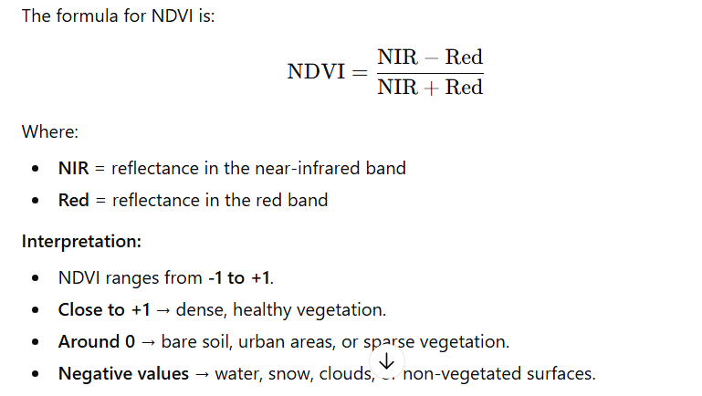
What is the normalised difference vegetation inxex
a widely used remote sensing index that measures vegetation health and density. It leverages the difference in how plants reflect red and near-infrared (NIR) light.
+1 dense healthy vegetation
0 = bare soil, urban areas
What are applications of NDVI?
agricultural production
land cover change
forest monitoring
vegetation health monitoring
what should thematic maps be accompanies by?
accuracy assessment based on independent ground reference data collected using a valid sampling scheme
What are the use of confusion matrices?
allow the calculation of overall accuracy of thematic data products as well as indicating the accuracy of individual classes
compares classified pixels and reference ground truth pixels
for example check that a forest misclassified as grass!!
What is training data?
areas on an image where you already know what the land cover is
construction of tranining spectral signatures;
select training areas
extract spectral data
build signature database
classify the images - the algorithm compares unknown pixels to the trained signatures and assigns them to the closest matching class
What makes a good training site?
representative of entire spectral space of class
have minimal overlap with other signatures
What is minimum distance classifier?
classifies a pixel based on distance to class mean
What is parallelpiped classifier?
It classifies pixels in multispectral images by determining whether they fall within defined boundaries (parallelepipeds) around the mean values of each class in feature space.
its the box rule
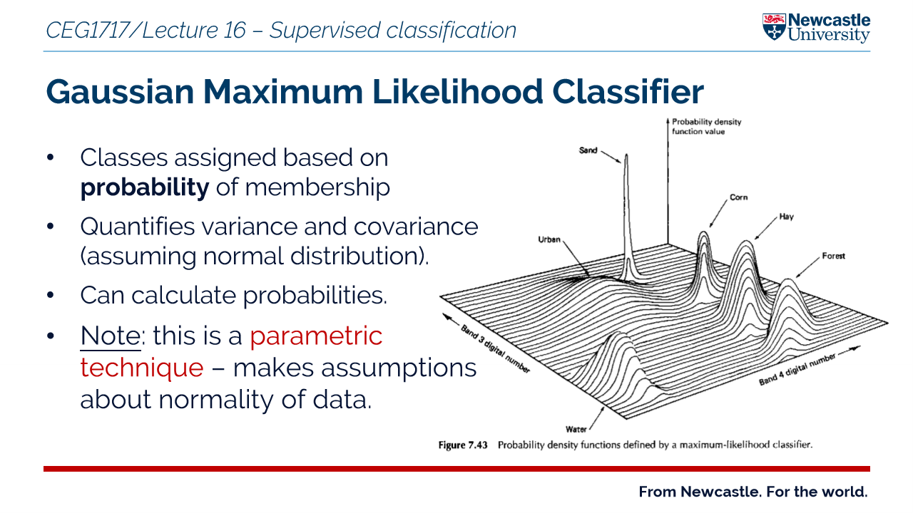
What is gaussian maximum likelihood classifier?
classes assigned based on probability of membership
It assigns a pixel to the class it is most likely to belong to (highest probability)
Height = likelihood of a pixel belonging to that class
What are the two types of error to look out for in classification?
errors of omission = sample not included in actual class like a forest pixel classified as urban
errors of commission = sample wrongly included in a class like a forest polygon is mapped in an area where there is actually no forest
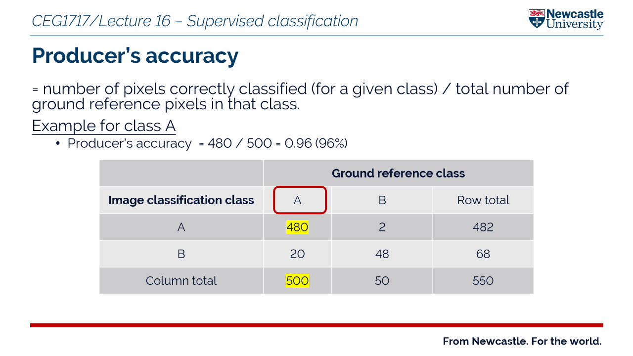
Producer accuracy vs consumer accuracy
producer accuracy = probability that a reference sample is correctly classified in the map = accounts for errors for omission
users accuracy = probability that a pixel classified as a given class actually represents that class on the ground = accounts for errors of commission
What is the kappa statistic
A measure used in remote sensing to evaluate classification accuracy - it goes further than overall accuracy
Help asssess how reliable your land cover classification really is
takes into account the number of reference points that could be correctly classified by chance