A-Level AQA Geography - Coastal Systems and Landscapes
1/225
Earn XP
Description and Tags
Name | Mastery | Learn | Test | Matching | Spaced | Call with Kai |
|---|
No analytics yet
Send a link to your students to track their progress
226 Terms
What type of systems are coastal systems?
Open systems
Examples of inputs into a coastal landscape
- Energy from: waves, wind, tides, sea currents
- Sediment
- Geology of coastline
- Sea level change
Examples of transfers within a coastal landscape
- Erosional processes
- Wind and water transport
Examples of components within a coastal landscape
- Erosional landforms and landscapes
- Depositional landforms and landscapes
Examples of outputs out of a coastal landscape
- Dissipation of wave energy
- Accumulation of sediment above the tidal limit
- Sediment removed beyond local sediment cells
What is an example of negative feedback within a coastal environment?
A beach in dynamic equilibrium. Sediment is eroded from the beach during a storm. Sediment is deposited offshore forming an offshore bar. Waves now forced to break before reaching the beach dissipating their energy and reducing further erosion when they reach the beach. When the storm calms, normal wave conditions rework sediments from the offshore bar back to the beach. A beach is in dynamic equilibrium.
What is an example of positive feedback within a coastal environment?
People walking over sand dunes. This damages and destroys the vegetation stablising the sand dunes. This causes more erosion of the sand dune, which in turn weakens the dunes. More sand is eroded away. This damages and destroys the vegetation stablising the sand dunes.
What are coastal zones?
-Backshore
- Foreshore
- Inshore
- Offshore
- Nearshore
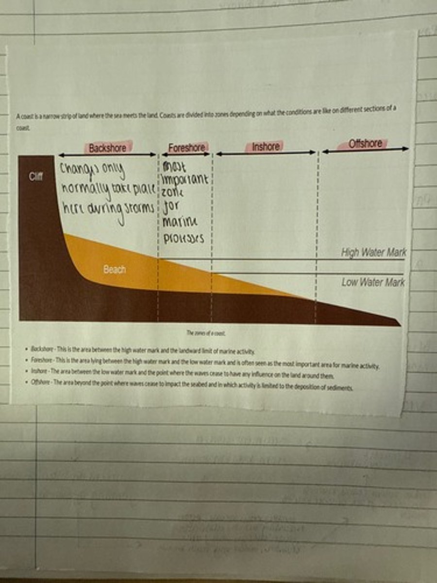
What is backshore?
The area between the high water mark and the landward limit of marine activity. Changes normally take place here only during storm activity.
What is foreshore?
The area between the high water mark and the low water mark most important zone for marine processes in times that are not influenced by storm activity.
What is inshore?
The area between the low water mark and the point where waves cease to have any influence on the land beneath them.
What is offshore?
The area beyond the point where waves cease to impact upon the seabed and in which activity is limited to deposition of sediments.
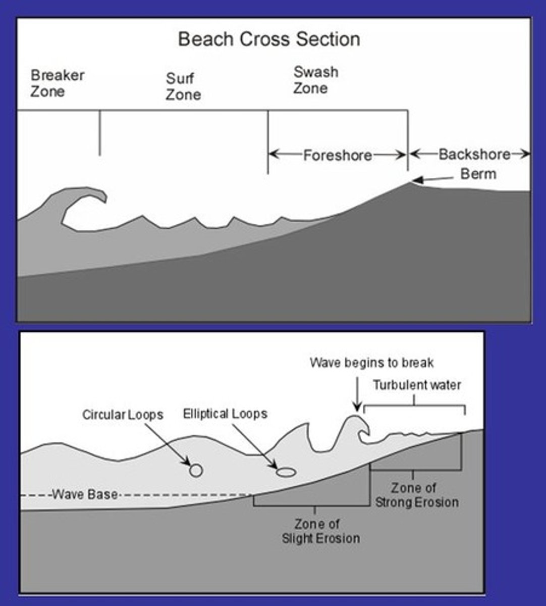
What is nearshore?
The area extending seaward from the high water mark to the area where waves begin to break. It includes the following:
- Swash zone
- Surf zone
- Breaker zone
What is the swash zone?
The area where a turbulent layer of water washes up the beach following the breaking of a wave.
What is the surf zone?
The area between the point where waves break, forming a foamy, bubbly surface, and where the waves then move up the beach as swash in the swash zone.
What is the breaker zone?
The area where waves approaching the coastline begin to break, usually where the water depth is 5-10m.
What is erosion?
The wearing away of the Earth's surface by the mechanical action of processes of wind, glaciers, rivers, marine waves and wind.
What is fetch?
Refers to the distance of open water over which a wind blows uninterrupted by major land obstacles. The length of the fetch helps to determine the magnitude (size) and energy of the waves reaching the coast.
What is mass movement?
The movement of material downhill under the influence of gravity, but may also be assisted by rainfall.
What is weathering?
The breakdown and/or decay of rock at or near the Earth's surface creating regolith that remains in situ until it is moved by later erosional processes. Weathering can be mechanical, biological/organic or chemical.
What are features of wind as an input into the coastal system?
- Spatial variations in energy result from variations in strength and duration of the wind. Where wind speed are persistently high and uninterrupted, wave energy is likely to be higher. Although local weather patterns may influence short-term changes in wind speed and direction, most coastlines will have a prevailing wind direction. It is an important factor that controls the direction that waves approach and the direction of the transport of materials in the coastal zone.
- The fetch.
- Helps create waves.
- Wind acts as an agent of erosion as it can firstly pick up and remove sediment from the coast and use it to erode other features.
How are waves created?
By the transfer of energy from the wind blowing over the sea surface (referred to as the 'frictional drag' of the wind). The energy acquired by waves depending upon the strength of the wind, the length of time it is blowing and the fetch.
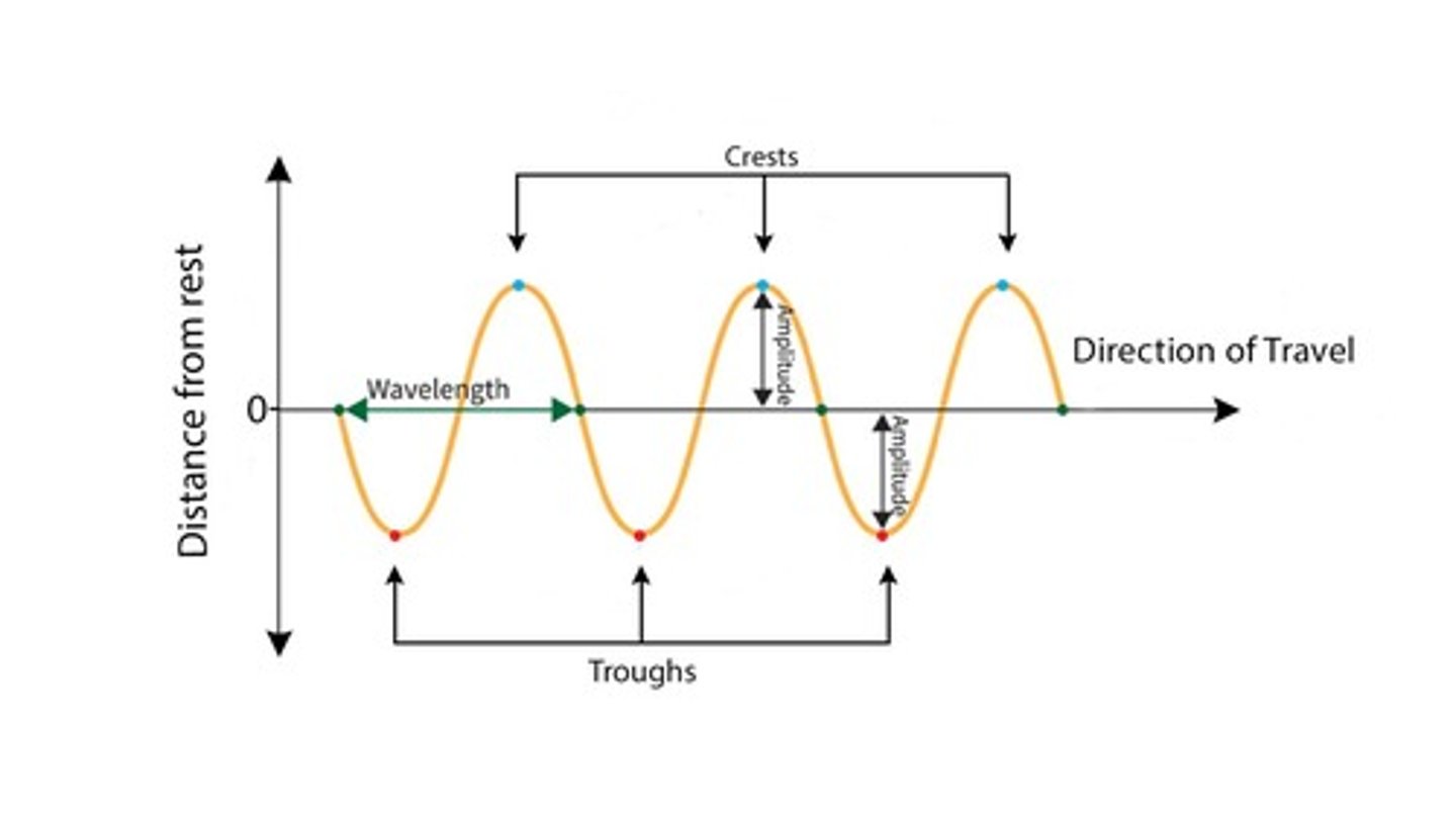
Key characteristics of waves
- Wave height: This is the height difference between a wave crest and the neighbouring trough
- Wavelength or amplitude: this is the distance between successive crests
- Wave frequency or wave period: this is the time for one wave to travel the distance of one wavelength, or the time between one crest and the following crest passing a fixed point
What is swash?
The rush of water up the beach after a wave breaks.
What is backwash?
The action of water receding back down the beach towards the sea.
What happens when a wave approaches shallow water?
Friction with the seabed increases and the base of the wave begins to slow down. This has the effect of increasing the height and steepness of the wave until the upper part plunges and the wave 'breaks' onto the shore.
What are constructive waves?
Waves with:
-low wave height
-long wave length
-low frequency (6-8/min)
-powerful swash
-weaker backwash
-beach material is built up
What are destructive waves?
Waves with:
-high wave height
-steep form (short wave length)
-high frequency (10-14/min)
-powerful backwash
-weaker swash
-sediment is removed
What do constructive waves form?
Berms
What do destructive waves form?
Storm beaches
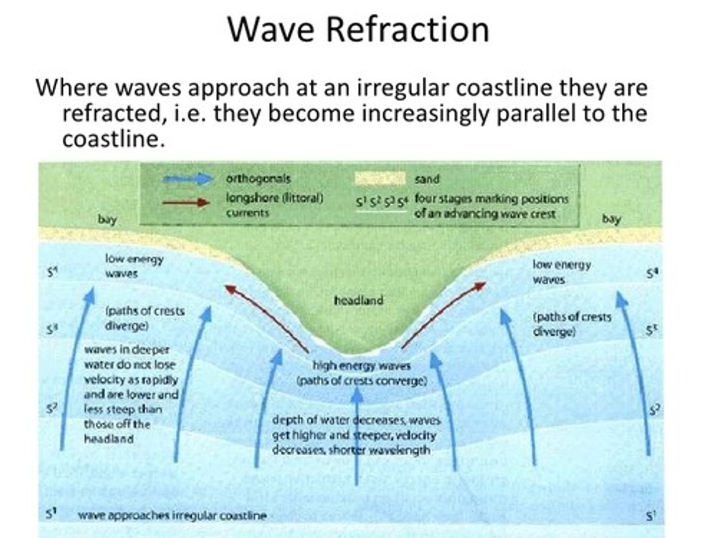
How does wave refraction affect a coastline?
The shape of a coastline controls how waves behave. When waves approach an irregular coastline, they are refracted, becoming more parallel to the shore. As they enter shallow water near headlands, they slow down, increasing in height and steepness while their wavelength shortens. The section of the wave still in deeper water moves faster, causing the wave to bend. This concentrates wave energy on headlands, leading to increased erosion. In contrast, lower-energy waves move into bays, encouraging deposition and beach formation. Additionally, water piling up against headlands can cause a slight rise in sea level, generating a longshore current that transports eroded material toward bays, further contributing to beach build-up.
What is a current?
The permanent or seasonal movement of surface water in the seas and oceans.
What are the three types of currents?
- Longshore currents
- Upwelling
- Rip currents
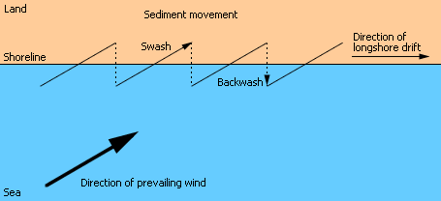
What are longshore currents? (Littoral Drift)
They occur because most waves do not hit the coastline 'head on' but approach at an angle to the shoreline. This generates a flow of water (current) running parallel to the shoreline. This not only moves water along the surf zone but also transports sediment parallel to the shoreline.
What are rip currents?
Strong currents moving away from the shoreline. Develop when seawater 'piles up' along coastline. Initially the current may run parallel to the coast before flowing out through the breaker zone, possibly at a headland or where the coast changes direction. Extremely hazardous to swimmers and small boats.
What is upwelling?
The rising of cold water from deeper layers to replace warmer surface water. These currents form part of the pattern of global ocean circulation currents.
What is longshore/ littoral drift?
Where waves approach the shore at an angle and swash and backwash then transport material along the coast in the direction of the prevailing wind and waves.
What is wave refraction?
When waves approach a coastline that is not a regular shape, they are refracted and become increasingly parallel to the coastline. The overall effect is that the wave energy becomes concentrated on the headland, causing greater erosion. The low-energy waves spill into the bay, resulting in beach deposition.
What are tides?
The periodic rise and fall of the level of the sea in response to the gravitational pull of the sun and the moon.
How are tides caused?
The moon has the strongest effect on tides because it is closer to Earth than the sun. Its gravitational pull creates a high tide on the side of Earth facing it and a corresponding bulge on the opposite side, while areas between these bulges experience low tide. As the moon orbits Earth, these high tides move with it.
Twice each lunar month, when the moon, sun, and Earth align, their combined gravitational pull produces the largest tidal range, known as spring tides. Also twice a month, when the moon and sun are at right angles relative to Earth, their forces partially cancel out, creating the smallest tidal range, called neap tides, during which tides are 10-30% lower than average.
Tidal patterns are further influenced by local factors such as seabed shape, nearby landmasses, and Earth's rotation (the Coriolis force).
Why is tidal range a significant factor in the development of a coastline?
Tidal range is the difference in height of sea water at high and low tide. This is not fixed. Tidal ranges determine the upper and lower limits of erosion and deposition and the amount of time each day that the littoral zone is exposed and open to sub-aerial weathering.
How do tidal/storm surges affect the shape of a coastline?
They are occasions when meteorological conditions give rise to strong winds which can produce much higher water levels than those at high tide. The sea level can rise by about one centimetre for every one millibar drop in pressure. Strong winds drive waves ahead of the storm, pushing the sea water towards the coastline: this has the effect of piling-up water against the coast. High tides, especially those of a spring tide, intensify the effect.
What is a coastal sediment budget?
The balance between sediment being added to and removed from the coastal system, that system being defined within each individual sediment cell.
What is a high energy coastline?
- Coastlines where strong, steady prevailing winds create high energy waves.
- The rate of erosion is greater than the rate of deposition.
- Typical landforms include headlands, cliffs and wave-cut platforms.
What is an example of a high energy coastline?
Examples of high energy coasts are the exposed Atlantic coasts of northern Europe and North America, including the north Cornish coast in south-west England. Also, the Isle of Orkeny, Scotland.
What is a low energy coastline?
- Coastlines where wave energy is low.
- The rate of deposition often exceeds the rate of erosion of sediment.
- Typical landforms include beaches and spits.
What is an example of a low energy coastline?
Examples include many estuaries, inlets and sheltered bays. The Baltic Sea is one of the best examples due to its sheltered waters and low tidal range.
What is a sediment cell?
A distinct area of coastline separated from other areas by well-defined boundaries, such as headlands and stretches of deep water.
What are sources of coastal sediment?
- Streams or rivers flowing into the sea
- Estuaries
- Cliff erosion
- Offshore sand bank
- Material from a biological origin (including shells, coral fragment and skeletons of marine organisms)
How many sediment cells are there in England and Wales?
11
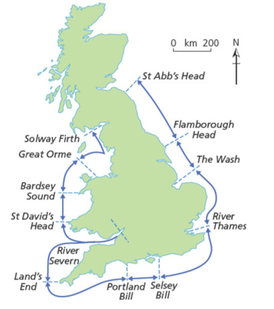
What type of system are sediment cells?
Closed
Explain a positive sediment budget
More material is added to the cell than is removed - a net accretion of material. This causes a surplus of sediment, meaning the shoreline builds towards the sea.
Explain a negative sediment budget
More material is removed from the cell then added. This causes a deficit in sediment supply, causing the shoreline to retreat landward.
What are marine processes? (geomorphological process)
Processes that operate upon a coastline that are connected with the sea such as waves, tides and longshore drift.
What are sub-aerial processes? (geomorphological process)
Includes processes that slowly (usually) break down the coastline, weaken the underlying rocks and allow sudden movements or erosion to happen more easily. Material is broken down in situ, remaining in or near its original position. These may affect the shape of the coastline, and include weathering, mass movement and run-off.
What are the 5 ways that a coastline can be eroded?
- Hydraulic action
- Wave quarrying
- Abrasion/ corrasion
- Attrition
- Solution (corrosion)
What is hydraulic action?
The impact on rocks from the sheer force of the water itself. This can exert enormous pressure upon a rock surface, thus weakening it. Such activity is sometimes referred to as wave pounding.
What is wave quarrying?
A breaking wave traps air as it hits a cliff face. The force of water compresses this air into any gap in the rock face, creating enormous pressure within the fissure or joint. As the water pulls back, there is an explosive effect of the air under pressure being released. The overall effect of this over time is to weaken the cliff face. Storms may then remove large chunks of it.
What is abrasion/corrasion?
The material the sea has picked up also wears away rock faces. Sand, shingle and boulders hurled against a cliff line will do enormous damage. This is also apparent on inner-tidal rock platforms where sediment is drawn back and forth, grinding away at the platform.
What is attrition?
The rocks in the sea which carry out abrasion are slowly worn down into smaller and more rounded pieces.
What is solution/corrosion?
Soluble, calcium-based rocks get gradually dissolved by the seawater.
What 6 factors affect the rate of coastal erosion?
- Wave steepness and breaking point
- Fetch
- Sea Depth
- Coastal configuration
- Beach presence
- Human activity
How does wave steepness and breaking point affect the rate of coastal erosion?
Steeper waves and high energy waves and have greater erosive power than low energy waves. The point at which waves break is also important; waves that break at the foot of a cliff release more energy than those that break some distance from the shore.
How does fetch affect the rate of coastal erosion?
How far the wave has travelled determines how much energy has been generated in it.
How does sea depth affect the rate of coastal erosion?
A steeply-shelving seabed at the coast will create higher and steeper waves.
How does coastal configuration affect the rate of coastal erosion?
Headlands attract wave energy through refraction.
How does beach presence affect the rate of coastal erosion?
Beaches absorb wave energy and can therefore provide protection against marine erosion. Steep, narrow beaches easily dissipate the energy from flatter waves, while flatter, wide beaches spread out the incoming wave energy and are best at dissipating high and rapid energy inputs. Shingle beaches also deal with steep waves as energy is rapidly dissipated through friction and percolation.
How does human activity affect the rate of coastal erosion?
People may remove protective materials from beaches (sand and shingle), which may lead to more erosion, or they may reduce erosion by the construction of sea defences. Sea defences in one place, however, may lead to increased rates of erosion elsewhere on the same coastline.
What is another important factor in the erosion of a coastline?
Geology
What is differential erosion?
When rocks are eroded at different rates due to their different hardness. Very resistant rocks e.g. granite and chalk are eroded more slowly than weaker rocks e.g. clay and limestone.
What is a concordant coastline?
When rocks lie parallel to the coastline (this is where you get one layer of hard rock preventing waves access to soft rock layer behind).
What is an example of a concordant coastline?
Lulworth Cove
What is a discordant coastline?
When rocks run at right angles to the coastline. This is where headlands and bays form.
What are the 5 processes of marine transportation?
- Traction
- Saltation
- Suspension
- Solution
- Longshore Drift
What is traction?
Large stones and boulders are rolled and slid along the seabed and beach by moving seawater. This happens in high energy environments.
What is saltation?
Small stones bounce or leapfrog along the seabed and beach by moving seawater. This process is associated with relatively high energy conditions. Small particles may be thrust up from the seabed only to fall back to the bottom again. As these particles land they in turn dislodge other particles upwards, causing more such bouncing movements to take place
What is suspension?
Very small particles of sand and silt are carried along by the moving water. Such material is not only carried but is also picked up, mainly through turbulence that exists in the water. Large amounts of suspended load, especially near estuaries can cause a milky or murky appearance of the sea.
What is solution?
Dissolved materials are transported within the mass of moving water.
What is longshore drift?
Where waves come in at an angle to the shore line, and material is pushed up the beach by the swash in the same direction as the wave approach. As the water runs back down the beach, the backwash drags material down the steepest gradient (perpendicularly) where it is picked up by the following incoming wave. Sediment is transported in a zigzag fashion along the coastline.
When does deposition occur?
- When sand and shingle accumulate faster than they are removed.
- As waves slow following breaking.
- As water pauses at the top of the swash before backwash begins.
- When water percolates into the beach material as backwash takes it back down the beach.
What are aeolian processes?
These refer to the entrainment, transport and deposition of sediment by wind.
What are the 2 types of aeolian deposition?
- Surface creep
- Saltation
What is surface creep?
A process similar to traction, where wind rolls or slides sand grains along the surface.
What is saltation? (aeolion version)
Where the wind is strong enough to temporarily lift the grains into the airflow to heights of up to 1 metre for distances up to 20-30m.
What is sub-aerial weathering?
Processes that slowly break down the coastline, weaken underlying rock and allow sudden movements or erosion to happen more easily. Material is broken down in situ
What are the 3 types of sub-aerial weathering?
- Mechanical/ physical weathering
- Biological weathering
- Chemical weathering
What is mechanical/ physical weathering?
In latitudes where temperatures fluctuate above and below freezing, freeze-thaw action is common. Water that enters cracks in the rock freezes as temperatures remain below 0°C. As it freezes, water expands by almost 10%, meaning ice occupies more space and so exerts pressure on the surrounding rock. As the process repeats, the crack widens and pieces of rock break off.
What is biological weathering?
The breakdown of rocks by the action of vegetation and coastal organisms/ Some marine organisms, such as the piddock (a shellfish), have specially adapted shells to enable them to drill into solid rock. They are especially active in areas with chalk geology where they can produce a sponge-like rock pitter with holes. Seaweed attaches itself to rocks and the action of the sea can be enough to cause swaying seaweed to prise away loose rocks from the sea floor. Some organisms, algae for example, secrete chemicals capable of promoting solution. Some animals can also weaken cliffs as they burrow or dig into them, such as rabbits or some cliff-nesting birds.
Where is an example of biological weathering taking place?
the Lake District National Park
What are the 6 types of chemical weathering?
- Solution
- Oxidation
- Hydration
- Hydrolysis
- Carbonation
- Acid rain (human activty)
How does oxidation break down rocks?
It causes rocks to disintegrate when oxygen dissolved in water reacts with some rock minerals, forming oxides and hydroxides. It especially affects ferrous, iron-rich rocks, and is evident by s brownish or yellowish staining of the rock surface.
How does hydration break down rocks?
It makes rocks more susceptible to further chemical weathering, although it involves the physical addition of water to minerals in the rock. This causes the rock to expand, creating stress, which can itself cause the rock to disintegrate. The process weakens the rock and can create cracks, or widen joints allowing further chemical weathering to occur.
How does hydrolysis break down rocks?
This is where mildly acidic water reacts or combines with minerals in the rock to create clays and dissolvable salts; this itself degrades the rock, but both are likely to be weaker than the parent rock, thus making it more susceptible to further degradation.
How does carbonation break down rocks?
CO2 dissolved in rainwater makes a weak carbonic acid. This reacts with calcium carbonate in rocks like limestone and chalk to create calcium bicarbonate which then dissolves easily in water. Carbonation is more effective in locations with cooler temperatures as this increases the amount of carbon dioxide that is dissolved in the water.
How does acid rain (human activity) break down rocks?
There are increasing levels of gases other than CO2 associated with industry and the burning of fossil fuels in the atmosphere that also react with rainwater making it mildly acidic. The presence of sulphur dioxide and nitric oxides can create rainwater with weak sulphuric and nitric acids. This acid rain then reacts with various minerals in different rocks weakening or even dissolving them.
What factors affect mass movement?
- The level of cohesion within the sediment.
- The height of the slope and slope angle.
- Grain size within the sediment.
- Temperature and level of saturation.
What are the 5 types of mass movement?
- Landslides
- Rock falls
- Mudflows
- Rotational slip/slumping
- Soil creep
What are landslides?
They occur on cliffs made from softer rocks or deposited material, which slip as a result of failure within it when lubricated, usually following heavy rainfall.
What are rock falls?
These occur from cliffs undercut by the sea, or on slopes affected by mechanical weathering like frost action.
What are mudflows?
Heavy rain can cause large quantities of fine material to flow downhill. Here the soil becomes more saturated and if excess water cannot percolate deeper into the ground surface layers become very fluid and flow downhill. The nature of the flow is dependent of the level of saturation, type of sediment and slope angle. On relatively gentle slopes the flows are often referred to as 'solifluction', creating lobe-like features towards the base of the slope.