Designing environmental monitoring programs
1/16
There's no tags or description
Looks like no tags are added yet.
Name | Mastery | Learn | Test | Matching | Spaced | Call with Kai |
|---|
No analytics yet
Send a link to your students to track their progress
17 Terms
Components of a monitoring program
Objective of monitoring
Quantifying xyz (e.g., accidental spills, long-term temporal conditions), better understand processes, fate of contaminants in environment, economics & governance.
Includes feedback (did we accomplish goal of project, is project succeeding, etc)
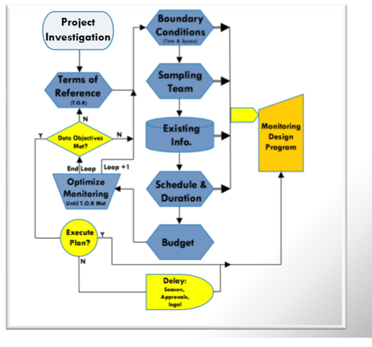
Terms of reference (after project investigation)
The details of the project: what is being investigated & why, what’s the sampling program, limitations/boundaries to the study, measurements needed, duration, sample frequency etc
Study boundaries
Defining boundaries of a body to be investigated to develop a monitoring program.
Body conditions internal vs external for a column experiment
Internal: diameters, length, open/closed ends to atmosphere, # + position + diameter of sampling ports, construction materials
External: temp, humidity, barometric pressure, vibration, light, radiation, sound, etc
Most environmental investigations can be defined by 3 principle boundary conditions. What are they?
Static state, assumed to be independent parameter (Type 1 or Dirichlet Boundary Condition)
Constant rate which specifies the 1st derivative of the dependent variable (Type 2 or Neumann Boundary Condition)
Variable rate or state which specifies a function of the dependent variable and its 1st variable (Type 3 or Cauchy Boundary Condition)
Sampling team consists of?
Project manager, subject experts, lab experts, data analysis & QA/QC, stakeholders
Project manager
Must understand requirements, have the knowledge of all particular disciplines, liaison across all actors, budget oversight.
Likely the greatest impairement that any investigation or monitoring program has is what?
Expectation for immediate answers in the absence of (or limited) info.
Desktop study
Objective is to collect & collate as much background info about a site as possible in time and space. Field work is expensive and takes years.
This data is usually available in GIS formats, previous reports, and speaking with people.
Aerial photography
Current & historical aerial photographic coverage provides valuable info on the consistency and/or change in land use. In many areas, aerial coverage has been captured over the past 80 years.
Identification of types of land use (+ buildings or ground operations such as airports) can provide insightful info (in inferences) regarding chemicals that may be used at a location, change in infiltration (from compaction), change in runoff (storm sewers), changes in water quality, etc.
Land use coverage mapping
In ON, 99 different land use types are delineated, from urban to farmland, swamps, lakes, water ways, etc. Can infer things like agro-chem use, transportation related contamination, water usage, evapotranspiration, infiltration, etc
Soil surveys
Used to estimate infiltration rates (related to hydraulic conductivity), soil chem, terrestrial species (& thus evapotranspiration), farming practices, tile drainage, and overland flow characteristics
Meterological data
Systematic measurements of precip, temp, wind speed & direction, barometric pressure, and solar radiation data are made across the country, which are available through Environment Canada. Monitoring data is also available through private monitoring systems like cities & municipalities.
Surface water flow data
Systematic measurements of river stage which are related to river discharge are made across Canada on a continuous basis at over 2500 locations. Data made available through Environment Canada (Water Survey of Canada).
Data include: peak annual discharge, mean daily, monthly & annual discharge observations and continuous readings.
Geology data
Record of borehole logs & well records are available through MECC (MECP). Incl water table info, sub surface geology, geochem. Geology maps available through ON Geological Survey
Schedule & duration - there are potentially several timelines to any given investigation. Examples?
Proponent, situational, scientific (chem, physical, biological), statistical, lifecycle, financial, geologic, etc