synoptic meteorology, hurricanes and tornados
1/14
There's no tags or description
Looks like no tags are added yet.
Name | Mastery | Learn | Test | Matching | Spaced | Call with Kai |
|---|
No analytics yet
Send a link to your students to track their progress
15 Terms
What is the inter-tropical convergence zone, where do we find it, how does it change over the course of the year, and why is it important for wind and precipitation patterns?
The Inter-Tropical Convergence Zone (ITCZ) is a region around the equator where the trade winds from the Northern and Southern Hemispheres meet.
Location and Annual Changes: It is found near the equator (0° latitude), but its exact position changes over the course of the year as it follows the north-south migration of the sun. In the summer, the ITCZ moves north, often sitting over landmasses like Asia.
Importance for Wind and Precipitation: The ITCZ is a zone of low pressure where hot, moist air is forced to rise. As this air ascends and cools, the water vapor condenses to form clouds, resulting in heavy increased precipitation and frequent thunderstorms. This migration is the primary driver of monsoon patterns, as the low pressure draws in moist oceanic air toward the continents during the summer months
Which way do low pressure systems circulate in the northern hemisphere? In the southern hemisphere? Why?
The direction in which low pressure systems circulate is determined by the Coriolis effect, a result of the Earth's rotation.
Northern Hemisphere: Low pressure systems circulate in a counter-clockwise direction.
Southern Hemisphere: These systems rotate in a clockwise direction.
Reasoning: In a low pressure system, warm air converges and rises. Air rushes inward from higher pressure areas to replace the rising air. Because the Earth rotates, this moving air is deflected—to the right in the Northern Hemisphere and to the left in the Southern Hemisphere—creating the characteristic spiral
What is the southern pacific oscillation? What happens to the oscillation in an el-nino year? In a la- Nina year? What does this mean for precipitation or drought in Australia?
The El Niño-Southern Oscillation (ENSO) is a cycle of variable air-sea coupled processes in the Pacific Ocean that results in year-to-year variations in global temperature and precipitation.
El Niño Year: Normal conditions are disrupted as the pool of warm water typically found in the Western Pacific moves eastward toward South America. This shifts the convective circulation and associated heavy rainfall away from the Western Pacific.
La Niña Year: This is an intensification of "normal" conditions, where even stronger trade winds pile up exceptionally warm water in the Western Pacific.
Impact on Australia: Because El Niño moves the warm, rain-producing water away from the region, it is typically associated with drought and fire hazards in Australia. Conversely, La Niña brings higher-than-average precipitation, often leading to heavy flooding.
What is a tropical cyclone? What conditions do they require to form (four things)?
A tropical cyclone is a violent low-pressure weather system with an organized wind circulation and sustained wind speeds of at least 120 km/hour (74 mph). They are called hurricanes in the Atlantic and Eastern Pacific, typhoons in the Western Pacific, and cyclones in the Indian Ocean.
Four Requirements for Formation:
Very warm surface ocean water (>26.5∘C) to a depth of at least 60 meters.
Coriolis effect (rotation): The storm must be at least 4° of latitude (about 450 km) away from the equator to initiate rotation.
Low vertical wind shear: There must be minimal differences in wind speeds between low and high altitudes.
Atmospheric Instability: Warm, humid air in the lower troposphere and cool air in the high troposphere to fuel the updraft through the release of latent heat.
Where do we find a tropical cyclone and why? What does the typical track of a hurricane look like over its lifespan and why? What times of the year do we find them in different ocean regions and why?
Location and Distribution: They are found in tropical ocean basins because these regions provide the necessary warm water. They do not form at the equator (0°–5° latitude) because the Coriolis effect is too weak there to cause rotation.
Typical Track: A typical hurricane track starts in the tropics, moves westward driven by trade winds, and then curves toward the poles as it encounters different wind bands. They die out quickly over land because they are cut off from the warm ocean water that fuels them.
Timing: Different ocean regions have "seasons" based on when sea surface temperatures are highest. For example, the Atlantic season peaks around September because that is when the ocean has absorbed the maximum amount of summer heat
What are the key hazards associated with Hurricanes?
High Winds: Extremely high sustained wind speeds that can destroy buildings and turn debris into missiles.
Storm Surge and Waves: In coastal areas, the "piling up" of water driven by wind and low pressure creates a surge that causes massive flooding. At sea, hurricanes generate massive "rogue" waves.
Precipitation: Intense rainfall leads to inland flooding and mass movements like mudslides. Flash floods from hurricane rains often kill more people directly than the winds themselves.
Thunderstorms and Tornadoes: Hurricanes often spawn secondary severe weather, including lightning and tornadoes, as they move over land
How do we measure the magnitude of a hurricane and why?
Hurricanes are measured using the Saffir-Simpson Intensity Scale, which categorizes storms from 1 to 5 based on their sustained wind speeds. This scale is used because it provides a reliable estimate of potential property damage and the expected storm surge height during landfall
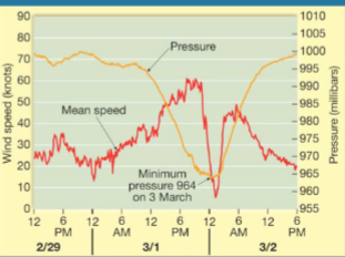
If we are standing directly in the path of a hurricane, describe what we would likely experience in terms of changes to wind, pressure, and rain during the time the storm approaches, hits us, and moves away. Use a labelled diagram to help explain your answer – time on the x axis and pressure and wind on the y axis.
If you were standing directly in the path of a hurricane, you would experience the following changes:
As the Storm Approaches: Atmospheric pressure begins to drop steadily. Wind speeds increase as the outer rainbands arrive, bringing intermittent heavy rain.
The Eyewall Hits: You experience the storm’s highest winds and greatest precipitation. The pressure continues to fall rapidly.
In the Eye: As the center of the storm passes over, the pressure reaches its absolute lowest point. Paradoxically, the winds become very weak or calm, and the rain may stop entirely.
The Eyewall Returns: As the eye moves away, the wind suddenly spikes to maximum intensity again, but from the opposite direction.
The Storm Moves Away: Pressure begins to rise, and wind and rain gradually diminish.
(Note: Based on source, a graph would show wind speed peaking twice—at the leading and trailing eyewalls—with a sharp dip in the center (the eye), while the pressure curve would be a single deep "V" or "U" shape reaching its minimum in the eye.)
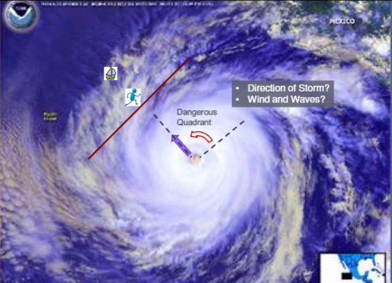
What is the dangerous quadrant of a hurricane in the northern and southern hemisphere, where is it found relative to the movement of a tropical cyclone, and why is it considered “dangerous”
The "dangerous quadrant" is the portion of the storm where the wind speeds are highest and the storm surge is most severe.
Location: In the Northern Hemisphere, it is the right-front quadrant relative to the storm's forward motion. In the Southern Hemisphere, it is the left-front quadrant.
Why it is "Dangerous": It is considered dangerous because the storm’s internal rotational wind speed and its translational (forward) speed are moving in the same direction. These two velocities are additive, creating a much higher "net wind" than on the opposite side of the storm, where the rotational winds are moving against the storm's forward motion.
Describe the relationship between tornado severity/magnitude, tornado frequency, tornado lifespan, and tornado related fatalities?
There is an inverse relationship between the frequency of tornadoes and their severity/lifespan:
Weak Tornadoes (EF0–EF1): These are the most common, accounting for about 69% of all tornadoes. They have short lifespans (1–10 minutes) and are responsible for less than 5% of fatalities.
Strong Tornadoes (EF2–EF3): These make up about 29% of tornadoes, typically last 20 minutes or longer, and cause 25–30% of deaths.
Violent Tornadoes (EF4–EF5): These are extremely rare, representing only 2% of all tornadoes. However, they have long lifespans (often exceeding an hour) and are responsible for approximately 70% of all tornado-related deaths
How do we measure tornado magnitude? What is it based on and why?
Tornado magnitude is measured using the Enhanced Fujita (EF) Scale, which replaced the original Fujita (F) Scale in 2007.
Basis of Measurement: The scale is based on consistent assessments of damage to structures and vegetation. Because it is extremely difficult to measure wind speeds directly inside a tornado’s vortex, meteorologists use the level of destruction as a proxy to estimate the wind speeds that must have occurred.
Why It Was Updated: The "Enhanced" scale provides more precise damage descriptors, using examples and photos of various structures to ensure more accurate wind speed assignments across different environments.
Where do we find the most tornados, when do we find them here, and why?
Location: Approximately 75% of the world's tornadoes occur in the United States, more than the rest of the world combined. The highest concentration is in the Midwest, a region known as "Tornado Alley".
Timing: While they can occur year-round, the majority develop in the spring and fall, with the peak frequency typically falling between April and June.
Reasoning: This distribution is driven by geography. Tornadoes thrive when cold, dry polar (cP) air from Canada collides with warm, moist tropical (mT) air from the Gulf of Mexico. The contrast between these air masses is greatest during the spring and fall, creating the unstable atmospheric conditions necessary for severe thunderstorms and tornadoes
North American tornados often occur in clusters which all tend to travel in the same direction. Why is this the case? Which direction and why?
North American tornadoes often occur in clusters (sometimes referred to as "outbreaks") because they are typically spawned by large-scale synoptic weather systems, such as cold fronts or Mesoscale Convective Systems (MCS).
Direction: These tornadoes tend to travel in a uniform direction, typically from the southwest toward the northeast.
Reasoning: Tornadoes are steered by the movement of their parent thunderstorms, which are governed by upper-level winds, specifically the jet stream. In the mid-latitudes of North America, these prevailing winds generally move from west to east or southwest to northeast, pushing entire weather systems along a consistent path
The number of observed tornados have been on the rise. Discuss possible reasons for this trend.
The number of observed tornadoes has been on the rise, with the U.S. now averaging about 1,200 per year.
Improved Detection: A primary reason for this trend is the advancement of monitoring technology, such as Doppler radar and weather satellites, which allow meteorologists to identify tornadoes that might have gone unrecorded in the past.
Reporting and Chasing: Increased public awareness and the rise of storm chasing (facilitated by scientific groups like Vortex2) have led to more frequent visual confirmations and reporting of smaller, short-lived tornadoes.
Climate Change: The sources also suggest that climate change may be a factor, potentially increasing the frequency of hazardous conditions or shifting tornado activity into new regions
Who should foot the bill for increasingly damaging typhoons, or tropical cyclones, or the complete relocation of many small island atolls that will be below sea level by the end of the century?
The responsibility for funding climate-driven damages and island relocation is currently divided between four main entities:
Historical Emitters: High-income, high-emissions nations (like the US and EU) are the primary contributors to the UN Fund for Responding to Loss and Damage, which recently began distributing grants in early 2026.
High-Emitting States (Reparations): Following a landmark 2025 ICJ ruling, states that fail to meet climate targets may now be legally held liable for "reparations" to vulnerable nations for loss of land and infrastructure.
The Fossil Fuel Industry ("Carbon Majors"): There is increasing pressure to fund relocation through Climate Damages Taxes on coal, oil, and gas extraction, alongside rising litigation against corporations for their role in intensifying tropical cyclones.
Regional Neighbors: Large neighboring nations are increasingly footing the bill through bilateral "lifeline" treaties—such as Australia’s agreement with Tuvalu—which provide both funding and guaranteed pathways for climate-driven migration.