Geology Final Exam Review
1/114
There's no tags or description
Looks like no tags are added yet.
Name | Mastery | Learn | Test | Matching | Spaced | Call with Kai |
|---|
No analytics yet
Send a link to your students to track their progress
115 Terms
Which statement best describes what happened to North America between about 400–300 million years ago?
North America collided with the continents of Europe, South America, and Africa.
Between 180 and 160 million years ago, what happened along the eastern margin of North America?
It rifted away from Africa and South America.
What plate did Florida belong to before 320 million years ago?
the same plate as Africa and South America
What happened in western North America between 180 and 60 million years ago as the Atlantic Ocean opened and formed in the east?
A new mountain belt formed in western North America.
What plate tectonic event created the Himalaya Mountains of south-central Asia?
collision between Asia and several continental fragments, the largest of which was India
Which of these statements about paleontology and continental drift is true?
Fossils of the seed fern glossopteris were found in rocks of the same age on several continents.
Which of the following is not one of the evidences used to support the theory of continental drift?
occurrence of earthquakes along the San Andreas fault
What features of the ocean basins that were revealed by echo soundings in the 1950s led most directly to the idea of seafloor spreading?
mid-ocean ridges
The discovery of magnetic records preserved in rocks confirmed which of the following ideas?
That the continents have drifted
Magnetic reversals in the rock record were first discovered on land. How did these reversals support the idea of seafloor spreading?
the pattern of reversals was found to be symmetric around the mid-ocean ridges
Which pattern of ocean sediment thickness gave support to the theory of plate tectonics?
thin around the mid-ocean ridges and thick near the continents

Which feature in the diagram is a divergent plate boundary?
A
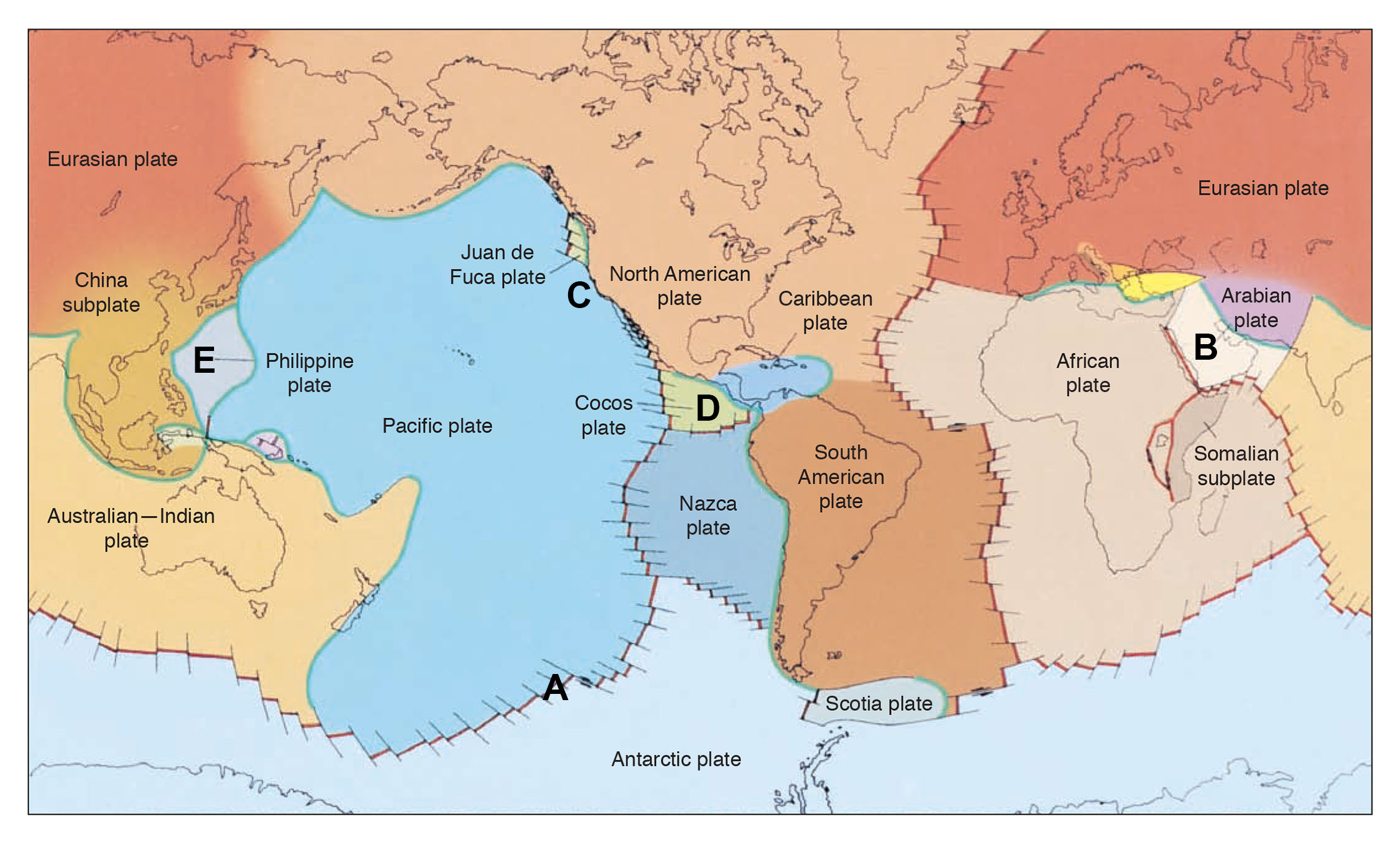
Which label in the diagram is on a plate that is surrounded by convergent plate boundaries?
E

What is the relative direction of the Nazca Plate motion with respect to the South American plate?
The Nazca plate is moving east relative to South America.

Near the point labeled C in the map, the Pacific plate is in contact with the North American plate forming a fault called the San Andreas fault. What type of plate boundary is this?
Transform
The rates of plate motion are quite variable. The fastest-moving plates have velocities of about which of the following?
10–20 cm per year
Which of the following are thought to be the main driving forces for plate motion?
slab pull and ridge push
Which of the recording stations is the farthest from the epicenter of the earthquake?
Jamestown
Which of the recording stations is just over 100 km from the epicenter of the earthquake?
Mineral
Where is the epicenter of the earthquake located?
due north of Yuba City
Is the earthquake shaking and damage likely to be greater in Jamestown, San Francisco, or Sacramento?
Sacramento
The Richter scale is actually a piece of equipment housed in the basement of a California laboratory that helps determine the size of an earthquake.
false
One of the problems with the original Richter scale was that it was not good for distinguishing large earthquake magnitudes (those greater than about magnitude 7).
true
The preferred magnitude scale used by most seismologists today is called which of the following?
moment magnitude, MW
Which of the following statements best expresses and models the occurrence of an earthquake?
Earthquakes occur when elastic energy stored in the rocks reaches a critical point where the energy is released in a quake.
Studies of seismic waves have shown that the interior of the Earth is most likely which of the following?
composed of layers of different composition and different physical properties

At which of the following locations on the map would earthquake occurrence be most likely in the next 100 years?
point A
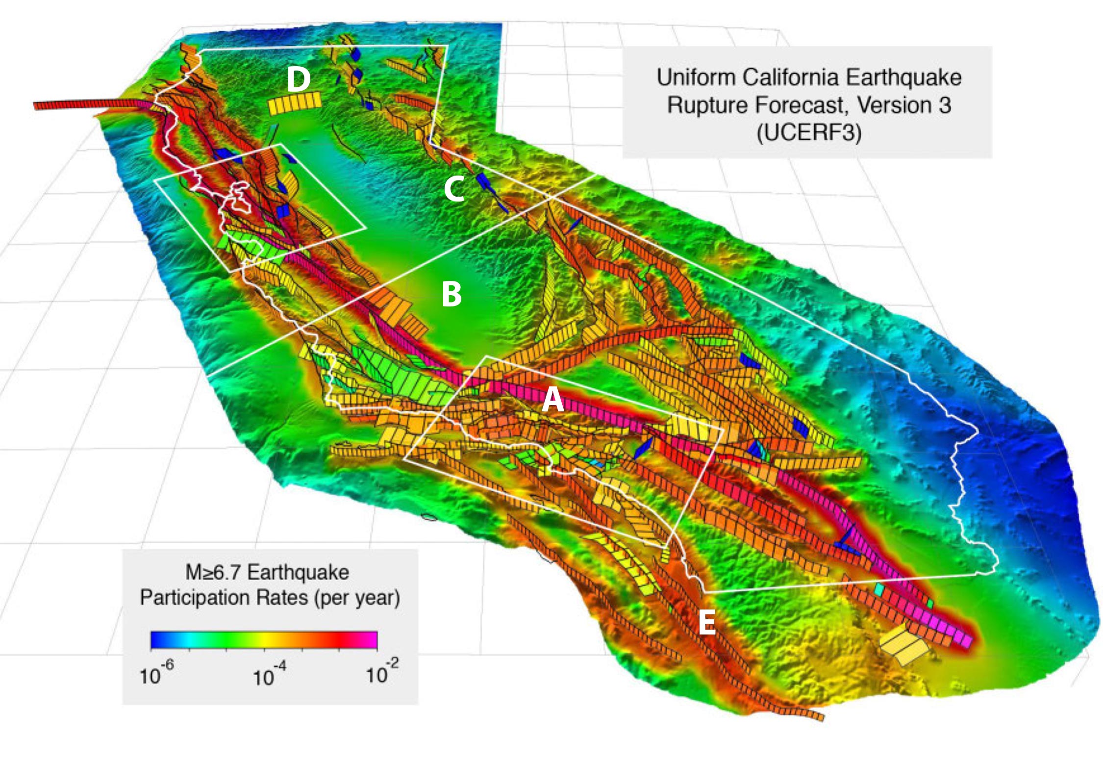
On the small fault below the letter D, how often should a magnitude 6.7 or greater earthquake occur?
once every 10,000 years

Which of the following statements is true according to the map?
Earthquakes in California are likely to strike the San Francisco Bay area (northern box on the map) in the next 100 years.
Which of the following would be true about the S-wave shadow zone if Earth’s core was smaller?
the S-wave shadow zone would be smaller
Which of the following would be true about the S-wave shadow zone if Earth’s outer core was solid?
the S-wave shadow zone would be more like the P-wave shadow zone
The main cause of the P-wave shadow zone is which of the following?
P-waves are bent strongly by the high density core.
If a large earthquake occurred at the North Pole, at which of the following locations could you not detect S-waves?
Rio de Janeiro, Brazil, about 23°S latitude
At which type of plate boundary would you be most likely to have deep focus earthquakes?
convergent boundaries
Why are there fewer damaging earthquakes in Iceland, which sits on the mid-ocean ridge plate boundary, as there are in Japan, which lies next to a collision boundary?
Divergent boundaries, like the mid-ocean ridge, typically have small magnitude earthquakes.
Which of the following is likely to occur to the Earth’s crust in an area of continental rifting?
The crust will become thinner because of stretching and extension.
Divergent plate boundaries are characterized by which of the following?
very young basaltic volcanic rocks and normal faulting
Only shallow earthquakes occur at the mid-ocean ridges because of which of the following?
The brittle lithosphere is so thin at the ridge that deep earthquakes cannot occur.
Which of the following represents an intermediate stage of rifting between continental rifting and oceanic rifting?
the Red Sea
Which of the following is the proper sequence of rock layers, from top to bottom, that is found in typical oceanic crust?
sediment, pillow basalt, sheeted dikes, gabbro
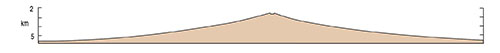
Which of these seafloor profiles is most representative of a slow spreading mid-ocean ridge?
B

The numbers in the diagram represent spreading rates. What are the most likely units for these rates based upon what you learned in your chapter?
centimeters per year
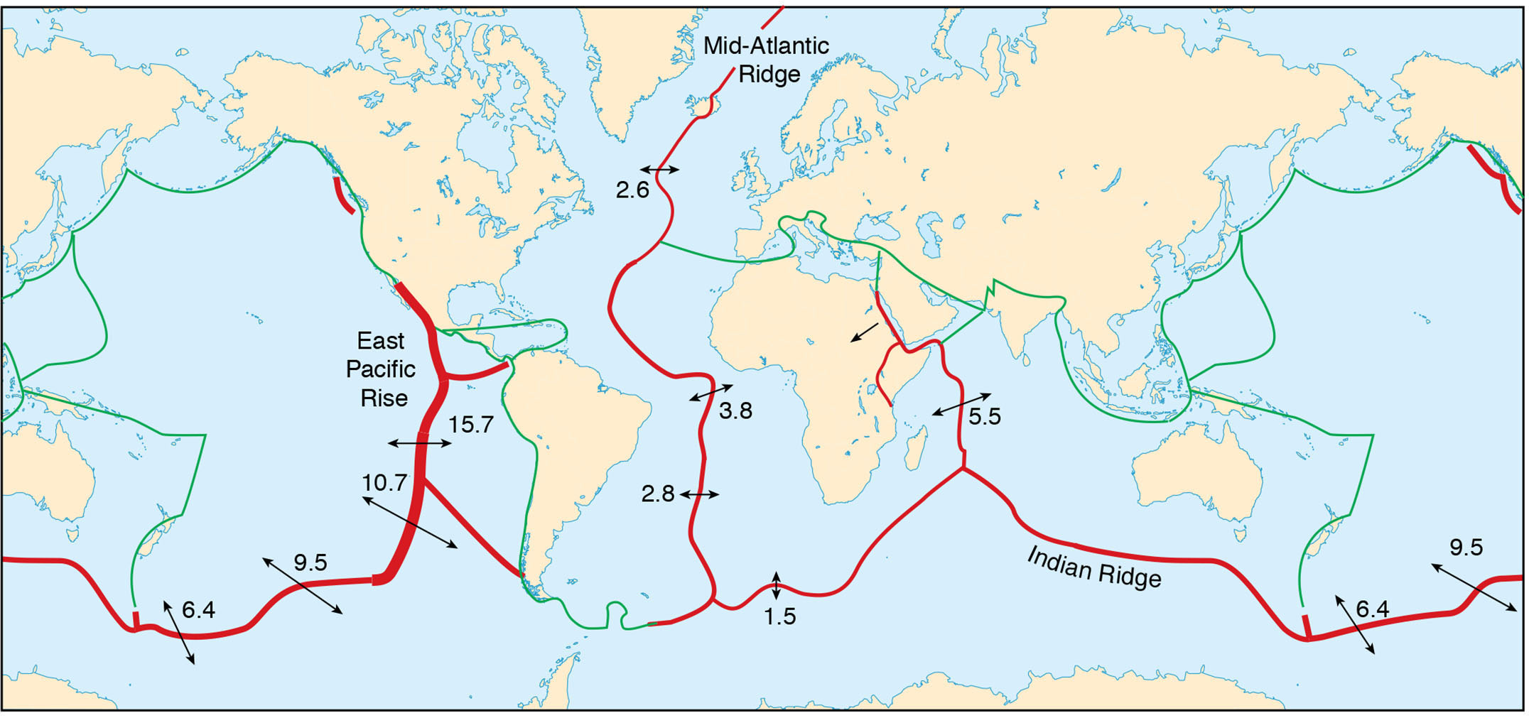
Which of the following explanations is the most likely cause for the high spreading rates along the East Pacific Rise?
The Pacific basin is surrounded mostly by subduction zones (green in diagram). This creates a strong slab pull force, aiding spreading.
How and where is magma generated along divergent plate margins?
just beneath the ridge as pressures decrease
In contrast to continental metamorphism, rocks along the mid-ocean ridges are mostly metamorphosed by the action of which of the following?
chemical action of fluids
Which of the following would not be found along a mid-ocean ridge divergent boundary?
abundant granite intrusions
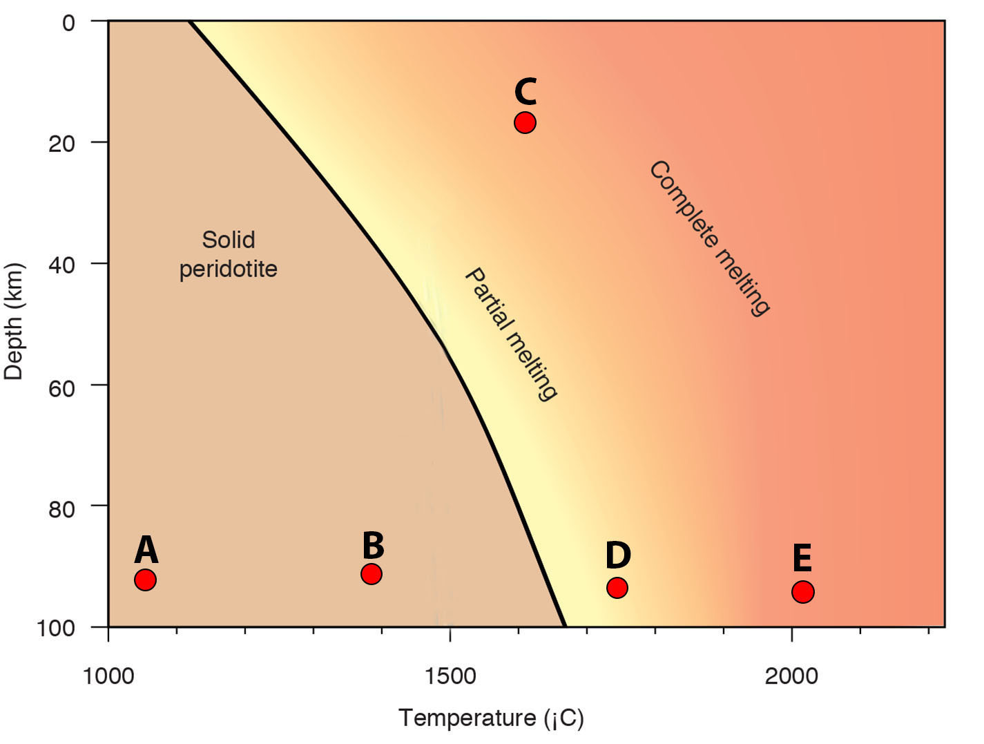
Which of these starting point rocks would change from a solid to partially liquid if the temperature remains constant and decompression occurs?
B

On what features are the points labeled B and E in the picture located?
transform faults
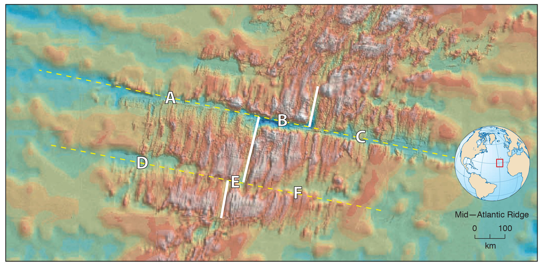
On what features are the points labeled A, C, D, and F in the picture located?
fracture zones

At which point in the figure would you be most likely to have frequent small earthquakes?
B
Which of the following is not true about transform plate boundaries?
New oceanic lithosphere is created at transform plate boundaries.
On the ocean floor, why is one side of a transform plate boundary sometimes higher in elevation than the other side?
One side is hotter than the lithosphere on the other side.
Earthquakes along oceanic transform plate boundaries are mostly small magnitude earthquakes, while on continental transform plate boundaries large magnitude earthquakes may occur.
True
Strike-slip faults are the most important type of fault found at transform plate boundaries.
True
The plate tectonic theory predicts that California will eventually sink into the ocean.
False
Transform plate boundaries are dominantly zones of which of the following?
horizontal shearing
The most abundant type of transform plate boundary is which of the following?
ridge-to-ridge transforms

What type of collision boundary is found at the Aleutian Islands and near Tonga?
ocean-ocean collision zone

What type of collision boundary is found along the west coast of South America?
continent-ocean collision zone

At which of the collision boundaries listed would you not find an associated deep ocean trench?
Himalaya collision zone
Which of the collision boundaries listed here would be the most volcanically active?
Mariana collision zone

Which of the following is most likely to develop into a continent-continent collision in the future?
Australia and Southeast Asia
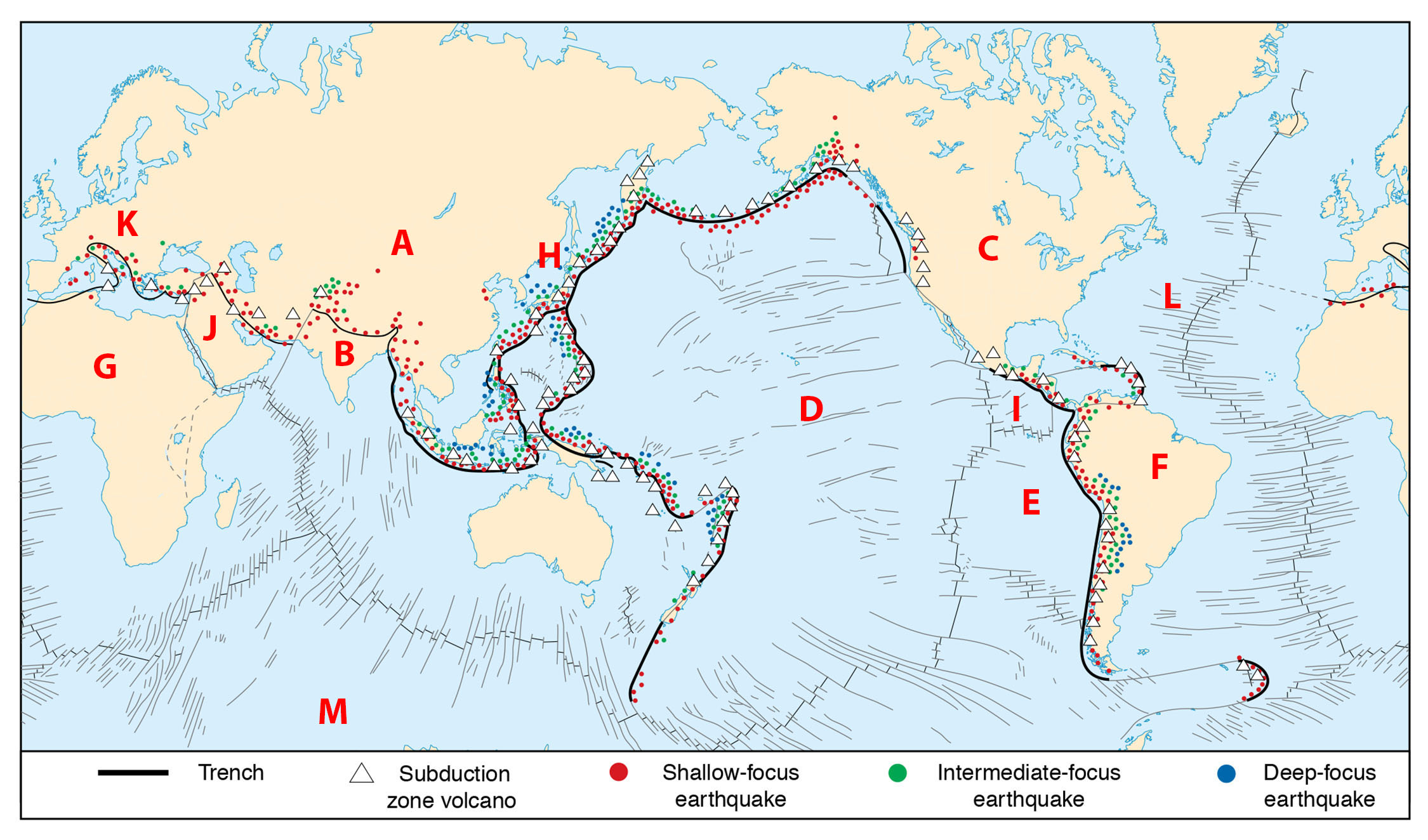
Where India (on plate B) runs into Asia (plate A) forming the Himalayas, why are there no deep-focus earthquakes (blue dots)?
The continental lithosphere of India and Asia is so buoyant that the subducting plate cannot get deep enough for deep-focus earthquakes.

Along the west coast of South America (plate F) what pattern of earthquake foci is observed?
Earthquake foci get deeper as you go to the east.

Based upon the earthquake foci, which of the following is true?
The Nazca plate (E) is subducting beneath South America (F).
Which of the following is not an important factor in determining the type and character of collision at a convergent plate boundary?
differences in buoyancy caused by Earth’s rotation
Plate velocity and direction play a major role in determining the type and character of a convergent plate boundary.
true
Magma generated at subduction zones would typically have all except which of the following properties?
typically have less silica than magma at ridges
Deformation at collision plate boundaries is best described by which of the following?
both compressional and extensional styles of deformation
Volcanic eruptions at collision plate boundaries are usually not very life-threatening, unlike those at divergent plate boundaries that may kill hundreds to thousands of people.
false
The continents have been about the same size as they are now throughout Earth’s history.
false
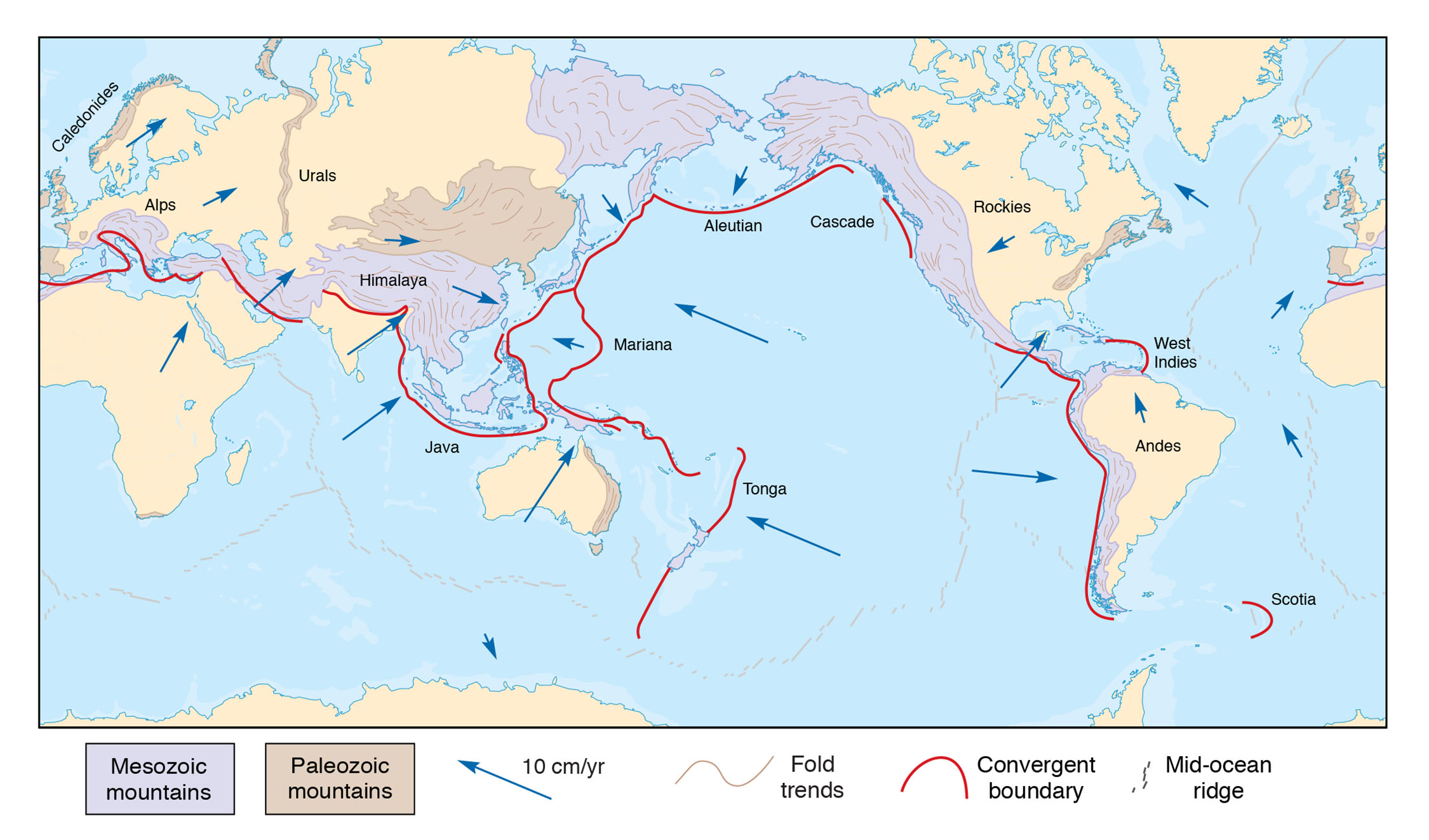
Studies of North America suggest that the continent grew by accretion through several major mountain building events.
Indirect evidence for mantle plumes comes from which of the following?
local zones of high heat flow
linear chains of volcanoes on plates
geochemical studies of lavas
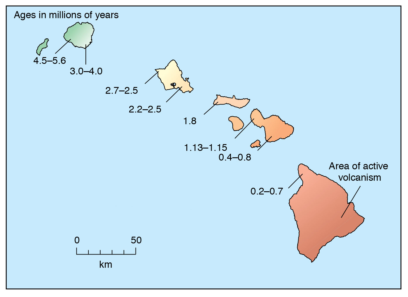
If this island chain has formed from a stationary hotspot, which direction has the plate moved over the last 5 million years?
northwest

Using the same map and the scale shown on the map, what is the approximate speed of the Pacific plate as it moves over this hotspot? Choose the closest approximate answer.
about 50 km/million years
The total volume of magma produced at the Earth’s hotspots exceeds the amount produced at all of the plate boundaries.
false
For most mantle plumes, which is larger, the head or tail of the plume?
head
As a mantle plume approaches the Earth’s lithosphere, which of the following is true?
It partially melts due to decompression.
Basalts form at hotspots, at mid-ocean ridges, and along island arcs. What is the most useful characteristic in helping scientists determine the tectonic setting in which a basalt formed?
the chemical composition of the basalt
Although hotspot volcanoes like the big island of Hawaii form atop large bulges in the Earth’s lithosphere, they also create a moat or depression immediately around the island.
true
Earthquakes associated with oceanic hotspots are typically like which of the following?
small magnitude and shallow focus
The Columbia River basalts and the calderas of the Snake River Plain are a good example of which of the following?
a mantle plume beneath a continent
Flood basalts are thought to be associated with which of the following?
eruption of magma from a mantle plume head onto the surface
During periods of high mantle plume activity and volcanic eruptions, which of the following is thought to be true?
global climate may become warmer due to release of carbon dioxide from volcanoes
an increase in oxygen in the atmosphere as plants convert carbon dioxide to oxygen
a decrease in the number of magnetic reversals of the Earth’s magnetic field
mass extinctions of certain life forms due to environmental changes
Mineral deposits are fairly uniformly distributed around the world so that most countries have access to what they need and use.
false
Unlike fossil fuels, most metals can be recycled and reused.
true
Mineral deposits are considered renewable natural resources because they are continuously being redeposited by the tectonic and hydrologic systems.
false

In which tectonic setting are most iron deposits found?
shield

In the United States, where would you be most likely to find a copper deposit?
Arizona
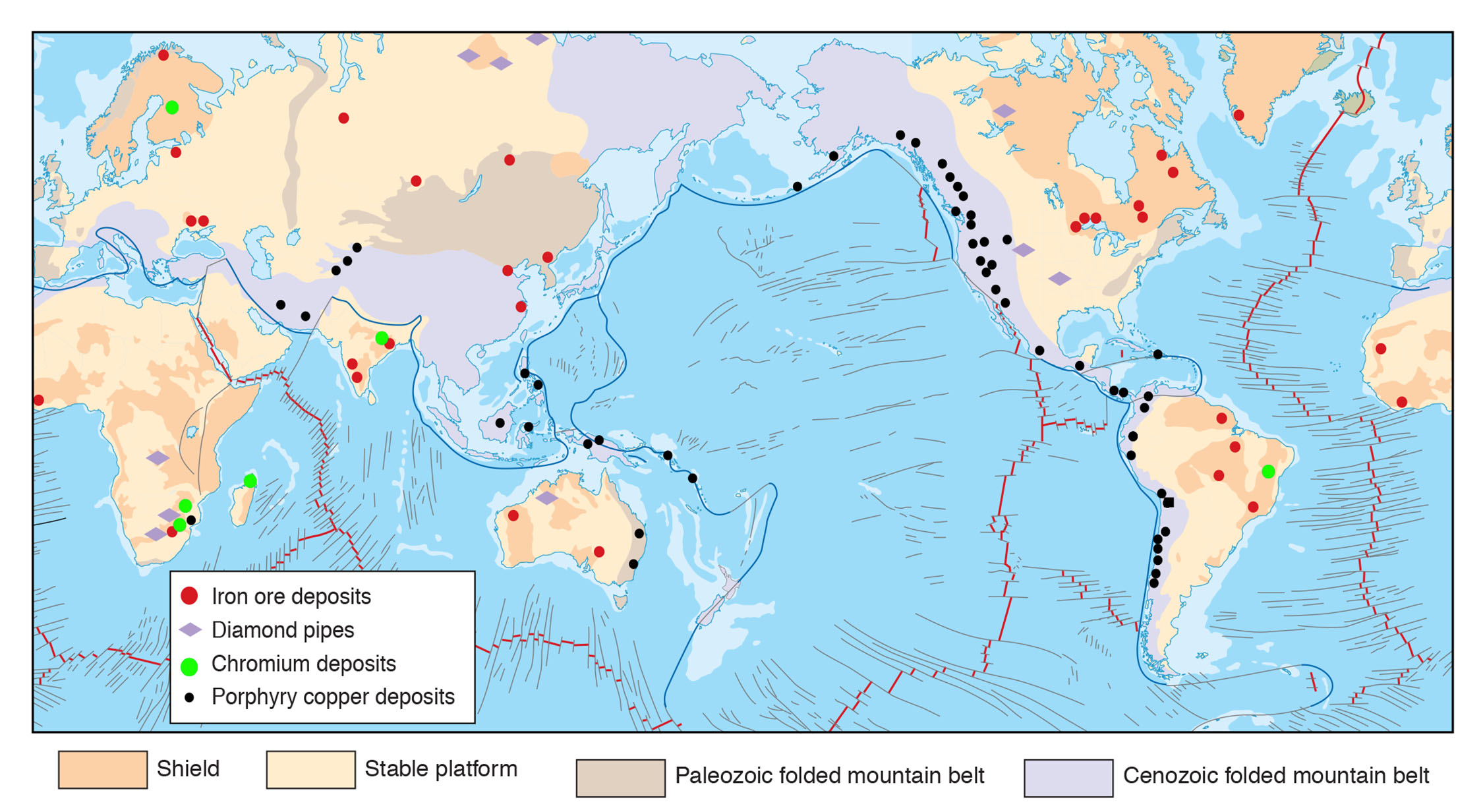
Chromium is a key element in the manufacture of stainless steel. Based upon the distribution of chromium deposits shown in the map, should the United States be concerned about the future availability of this metal?
Yes, the United States has allies with chromium deposits, but they are mostly in relatively unstable countries or with tentative allies.

In the United States, the majority of oil and gas deposits occur in which tectonic setting?
stable platform
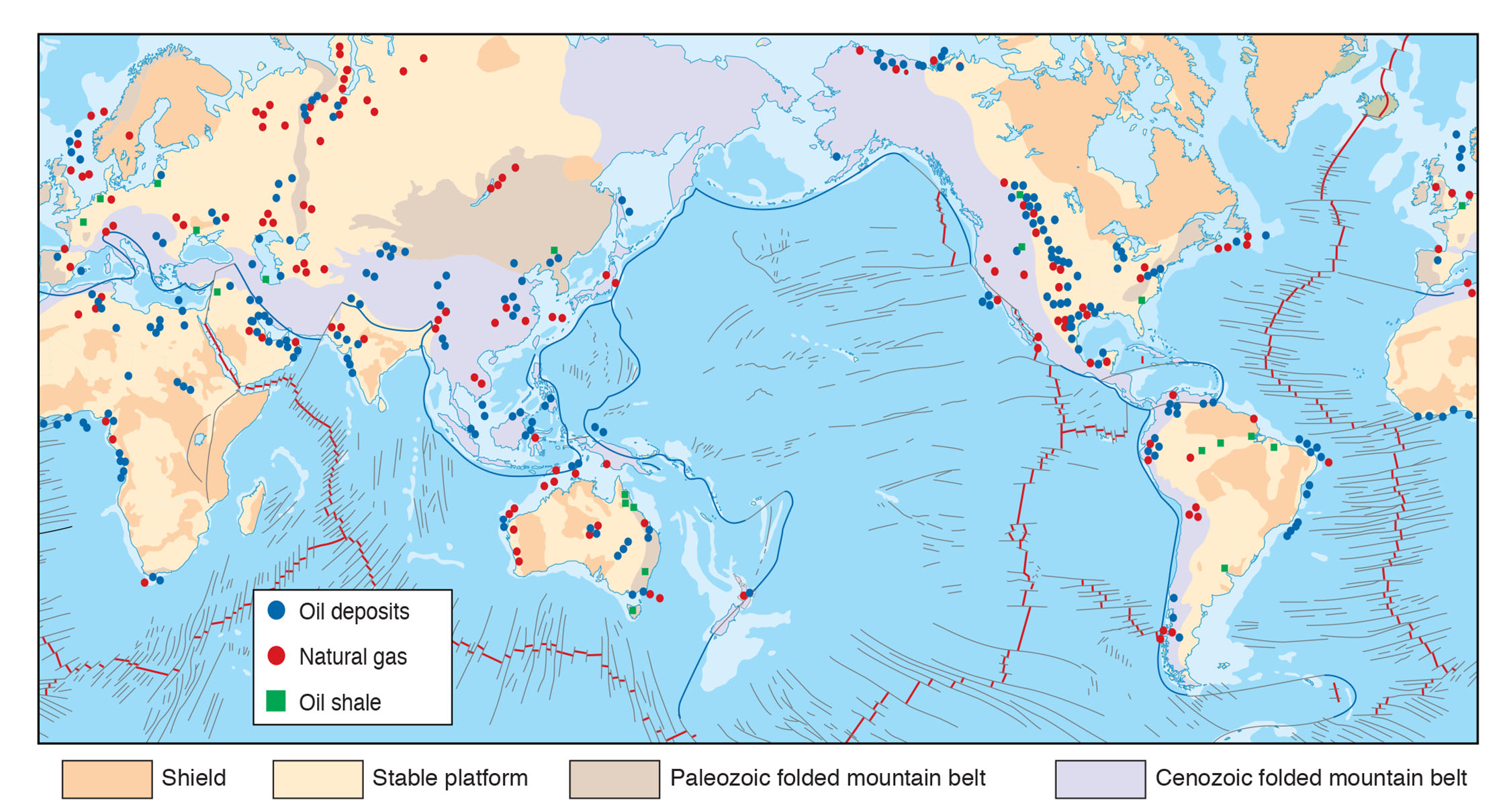
The tectonic ridges and trenches would be good locations to explore for more oil and gas.
false

Worldwide, the tectonic setting where you are least likely to find oil and gas deposits is which of the following?
shield

The graph in the image "ResourcePredictionGraph.jpg" suggests that by the year 2100 we will be completely out of coal and oil.
false
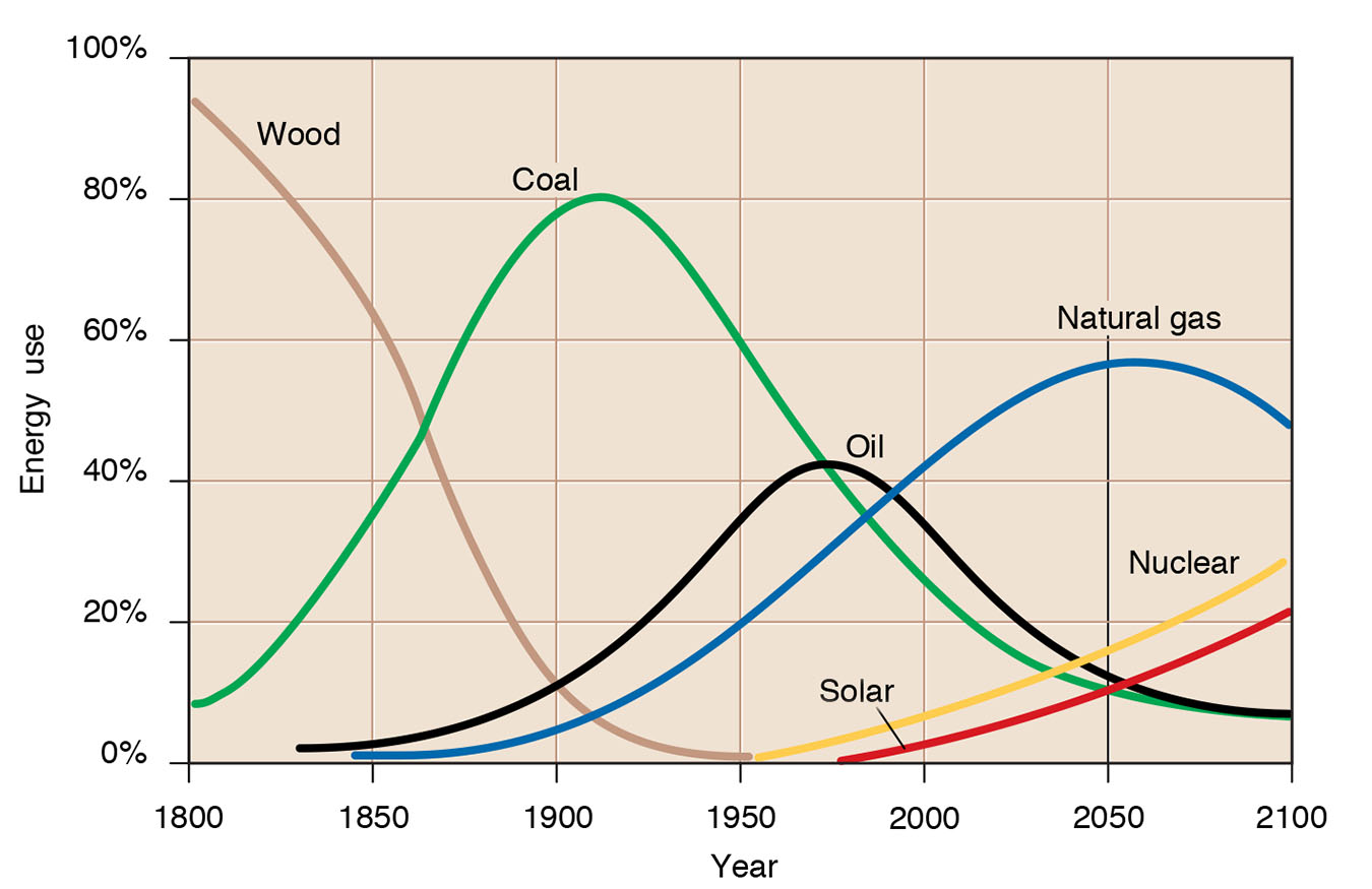
Which of the energy sources shown in the graph above would be considered renewable?
solar
Wind is one form of renewable energy. Which of the following is a problem in trying to use it more widely?
Wind energy cannot be directly used in trucks and cars; it is not very portable.
Individual windmills are expensive and in most cases not competitive with other forms of energy currently in use.
Some people find wind farms unsightly and a form of visual pollution.
Wind farms cause the death of large numbers of birds each year, including some that are endangered.
Most of the energy consumed in the United States today is renewable energy.
false
Which of the following processes is thought to be responsible for forming porphyry copper deposits?
hydrothermal fluids
Which of the fossil fuels listed here is thought to have been formed mostly from plants accumulated in ancient swamps?
coal
Which of the following is not considered an “inner” planet of the solar system?
Jupiter