Weather 1
1/44
There's no tags or description
Looks like no tags are added yet.
Name | Mastery | Learn | Test | Matching | Spaced | Call with Kai |
|---|
No analytics yet
Send a link to your students to track their progress
45 Terms
Insolation entering atmosphere:
26% reflected by clouds, gas/dust
18% absorbed by atmosphere
6% reflected by surface
50% absorbed earth surface
Factors which influence amount reflected at ground surface
Cloud cover - heavy cloud cover in location will absorb or reflect higher proportion of energy, thus reducing availability at ground surface.
atmospheric conditions - highly polluted atmosphere increase absorption and reflect which reduces energy availability at ground surface
Ground surface characteristics - reflectivity of surface e.g snow or ice can reflect up to 80% of insolation means less available for absorption at surface, ocean reflects 2% of inso
latitude in global temp
Atmospheric losses- equator sun overhead so rays travel directly to earth so shorter journey through earth atmosphere so less energy lost by scattering, reflection.
Land area heated - equator sun high overhead rays concentrated on small area heated intensely, distance from equator sun no overhead due to curvature of earth sun rays larger area heated less intensely.
Seasonality definition
changes in amount of insolatiation recived and temp experienced at earths surface
seasonality 21 june
Northern hemisphere - tilted towards sun - energy concentrated in northen hemisphere high temp due to small losses of energry through jounrey and intense heating of small area of land.
After June 21 tilt away less insolation longer journey high energy losses, larger area surface heated less intense, 21 Dec shortest day.
close to equator little varation in insolating inn year sun overhead all year, polar no insolation for part of year
Latitude and seasonality references to place
Narvik (Norway) 68oN lat- avg jan temp -3oc, June 9oC
London (England) 51oN lati- avg jan temp 4oC, June 18oC
Uaupes (Brazil) 0o lat- avg jan temp 26oC, June 26oC
Continentality definition
Interior of contingents being unaffected by crown influences effect climate
Continentality meaning
Winter - coastal areas high temp than inland, summer - coastal areas low temp than inland
Oceans heat and cool slower than land mass as water higher heat capacity than solid land surface, - twice more energy to heat water by 1 deg C than land, sun rays penetrate greater depth in water than solid, currents in ocean transfer heat energy to great depth so not easily lost.
Continentality references to place
London (England) - Coastal avg Jan temp 4oC, June temp 18oC
Kyiv (Ukraine)- Inland avg Jan temp -6oC, June temp 28oC
Relief/ altitude
Every 1000m up temp decrease by 10oC
- high alts , decreasing area of land surface to heat air above it
air pressure decrease gas molecules expands air not able to retain as much heat
Relief references to place
temperature at top of Slieve Donard (850m above sea level) is 5.1°C lower than in Newcastle Co. Down (at sea level)
Ocean currents
Uneven heating produces density diffs in oceans.
Cold dense polar air sinks, spreads towards equator where less dense warmer water moves towards polar.
East coast North America Labrador current - cold water from, polar to equator , lowers temp. North Atlantic drift - original Gulf of Mexico , warm current from trophic to poles , increase temp in British Isles
Ocean currents level reference to place
Stornoway, Scotland, North Atlantic Drift- avg Jan temp 5oC, June temp 13oC
Hopedale, Canada, Labrador Current- avg Jan temp -16oC, June temp 10oC
Energy balance
greatest energy surplus -Equator.
energy surplus between 40°N and 40°S- decreases with distance equator
40°N- 40°S balance between incoming energy from sun and outgoing heat from earth's surface.
40°N -90°N and 40°S - 90°S energy deficit i.e. outgoing heat from earth's surface greater than incoming energy sun. energy deficit increases
towards North Pole and South Pole.
• The North Pole and South Pole have the highest energy deficit.

Horizontal heat transfer :
low to high latitudes - global winds, ocean currents
Global winds horizontal heat transfer:
From low latitudes are warm + carry a lot of water vapour. As blow polewards (energy deficit areas)they bring their heat + as the cool, condensation from warm air - take place + latent heat is released into higher latitude.
Ocean currents horizontal heat transfer,
Warm ocean currents e.g North Atlantic drift originates in Gulf of Mexico (tropics) towards North Pole raise temps in N.Atlatnic. REDISTRIBUTES HEAT heat to deficit
Labrador current flows from N.pole towards equator brings cool water to areas of energy surplus
Vertical heat transfers -
Heat energy from ground to atmosphere, conduction, convection , radiation
Radiation vertical heat transfer
Heat moves as infrared waves from its source. From ground into lower atmosphere, heat waves hit cooler air, molecules of cooler air speed up making them hotter,
Conduction vertical heat transfer
In conduction areas of more heat to less heat by direct contact, warmer molecules vibrate rapidly collide with other nearby molecules moving them too. Heat transferred through matter.
Convection vertical heat transfer:
Heat radiates from ground initiates convection Cells in atmosphere, sun energy absorbed by ground surface by ground heats it , ground heats air above and its density increases, warm air rises removes excess heat from ground to atmosphere
When air sinks air pressure is
High
When air rises air pressure is
Low
Pressure gradient force affecting winds
Wind direction- difference in air pressure at ground surface - air pulled directly from high to low pressure ie cutting isobars at right angle
Wind speed- large diff in air pressure, pressure gradient steep wind speed fast.
Small diff in air pressure , pressure Gradient gentle wind speeds slow
Coriolis force affects what winds
Wind direction not speed
Coriolis force
Created by anti-clockwise rotation of earth on its axis , winds deflected:
Right in northern hemisphere
Left in southern hemisphere
Increases in strength with distance from equator , faster winds greater deflection
Friction
Air blows over land/ sea surface. Friction reduces speed of wind - reduces impact of Coriolis force
Hadley cell
Equator sun overhead short journey. Heat intensely. Ground heat air above it, warm air rise create low pressure at surface. Continued hearing of groin at equator creates updraughts of warm air force air risen to spread polewards. Air cools pressure increases density increases means air sinks towards surface at 30oN and 30oS so high pressure there.a
Air moves overland surface due to pressure gradient force from 30oN and 30oS high pressure to low pressure equator.
Coriolis force deflects air from 30oN to equator to right to form north east trade winds.
Air from 30oS to equator to left to form South East trade Winds.
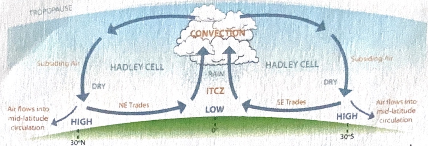
What is Inter tropical convergence zone
Zone of extreme low air pressure where North east trade winds and south east trade wind meet. Cluster of towering cumulonimbus clouds.

Polar cell
Northern and southern (60-90)Little insolation, very cold north n south pole chills air above it. Density increases so sinks gives high air pressure. At 60N n S low air pressure so pressure gradient force high at poles to low 60a. Coriolis force deflects 90N to 60N to right firm winds blowing north easterly, 90S to 60S left wind south easterly. Poles to 60n heated , air rises then return aloft to poles to complete convection cell.

Ferrel cell
30-60 north and south hemisphere. Driven by friction with Hadley cell and weak polar cell. At 30NS air subsided pushed towards 60NS rather equator. Air reaches 60NS friction with rising air of polar cell cause air rose. Rising at 60NS low air pressure at surface.
Polar front jet stream
Fast flowing belt of air 60N and 10km from surface in tropopause (upper atmosphere). Forms between polar and Ferrell cell where cold artic air converges with warm tropical air. Extreme temp diff creates very steep pressure gradient and high to low pressure pills and directly so speeds of 200mph common. Coriolis force strong due to speed of wind deflect fast moving air to right to give westerly air flow.
Relative humidity definition
weight of water which air is actually holding compared to amount it could hold at given temp and air pressure %
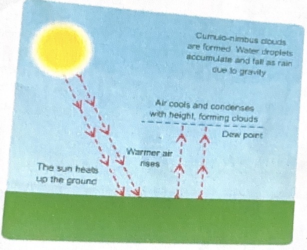
Conventional rainfall
Sun heats up ground, heat evaporates water from trees, land, warmer air rises, air pressure decreases, air expands , relative humidity increase, dew point 100%, forms droplets, condensation occurs latent heat released further instability and uplift, forms clouds, cumulonimbus clouds formed, water droplets accumulate and fall as rain due to gravity.
oriographic rainfall
Wind over ocean pick up moisture, Moist onshore winds forced over mountain air rises, density decreases,expands and cools relativity humidity 100% condensation occurs and layer of stratus cloud forms. Relief rainfall, leeward side - air dry air pressure increases, contracts, relative humidity decreasing, no condensation , air dry rain shadow.
Frontal rainfall
Frontal rainfall - warm fronts and cold fronts of mid-latitude depression.
Warm front tropical maritime rises over cold dense polar maritime air. Warm air rises, expands, cools relative humidity increases until its dew point is reached relative humidity 100%, condensation releases latent heat triggers more uplift, tiny droplets grow, form stratus clouds.
Cold front- polar maritime air flows behind tropical maritime undercut, warm air forced to rise, cool relative humidity increases, dew point, more undercut, condensation latent heat, more uplift, tint water droplets cloud cumulonimbus clouds form.
Very high annual rainfall Amazon Basin Up to 3000mm per year | ||
Low pressure belt - where NE and SE trade winds meet Sun high in sky - short journey through atmosphere (little losses) - concentrated on small area of land - surface heated intensely - air heated and huge amounts of evapotranspiration -air carries huge amount of water vapour - air rises (low pressure created) - cools - relative humidity increases - dew point reached - condensation - convectional rainfall - daily in afternoons. |
Precipitation at 0o Equator
Very high annual rainfall- Amazon Basin
Up to 3000mm per year
Low pressure belt - where NE and SE trade winds meet Sun high in sky - short journey through atmosphere (little losses) - concentrated on small area of land - surface heated intensely - air heated and huge amounts of evapotranspiration -air carries huge amount of water vapour
- air rises (low pressure created) - cools - relative humidity increases - dew point reached - condensation - convectional rainfall - daily in afternoons.
30o N/S precipitation
Low annual precipitation - Sahara Desert
Up to 100m per year
High pressure belt
Air that has travelled aloft from the Equator sinks. Air is dry as it shed its water vapour over the Equator. Also as air sinks, it's compressed and warms so can hold more water vapour - cloud formation and rainfall is suppressed.
60o N/S precipitation
Medium annual precipitation - British Isles
Up to 1400mm per year
Low pressure belt
Polar maritime air meets tropical maritime air. Tropical maritime air rises over polar maritime ait at fronts - frontal rainfall forms
High pressure belt Air from 60°N/S travels towards the Poles. Air is dry as water vapour was lost at 60°N/S and air is so cold that it cannot hold a lot of water vapour. At 90°N/S little insolation is received (long journey through atmosphere, large area heated and high reflectivity of surface, length of day/ night) - very cold. Air above ground is chilled and sinks, so cloud and PPT formation is suppressed |
90o N/S precipitation
Low annual precipitation - North Pole
Up to 30mm per year
High pressure belt
Air from 60°N/S travels towards the Poles. Air is dry as water vapour was lost at 60°N/S and air is so cold that it cannot hold a lot of water vapour. At 90°N/S little insolation Is received (long journey through atmosphere, large area heated and high reflectivity of surface, length of day/ night)
- very cold. Air above ground is chilled and sinks, so cloud and PPT formation is suppressed
Mountain ranges precipitation
High annual precipitatioj British Isles
Up to 3000mm per year
Air rises over coastal mountains - air contains a lot of water vapour - expands - cools by 6.5°C per 1000m - relative humidity increases, dew point reached, condensation, clouds and ppt form (relief/ orographic rainfall)
Even mountains away from coasts have high ppt totals - air is so cold - altitude - small area of land to heat air and with low air pressure gas molecules are so far apart, little heat can be stored - air very cold - dew point - condensation, clouds and ppt
Coastal locations precipitation
Western Europe- British Isles
Up to 1400mm per year
Winds blow across sea/ ocean - pick up water vapour - air is laden with moisture