rivers and groundwater
1/63
Earn XP
Description and Tags
f
Name | Mastery | Learn | Test | Matching | Spaced | Call with Kai |
|---|
No analytics yet
Send a link to your students to track their progress
64 Terms
Earth as a System: The Hydrological Cycle
illustrates the circulation of earths water supply
most water is in the oceans and is continuously recycled through processes such as evaporation, precipitation, and infiltration.
Water’s Path: What Processes are involved in the water cycle?
PEIRTR!
Precipitation
Evaporation
Infiltration
Runoff
Transpiration
Respiration
What is Evaporation?
Evaporation is water going from liquid to gas
What is CONDENSATION?
Condensation is gas that goes back to liquid
what is Precipitation?
Precipitation is water in any form returning to Earth’s surface
EX: Rain, Snow, etc.
what is Runoff?
Runoff is water flowing beneath Earth’s Surface
What is Transpiration?
Transpiration is water coming from plants
What is Respiration?
Respiration is water coming from animals
What is Simplified Water Cycle?
numbers that are in cubic kilometers
Running Water: The amount of water that remains on the surface as runoff depends on what?
Intensity and Duration of rainfall
Amount of water already in the soil
Nature of the surface materal
Slope of the land
Extent and type of vegetation
Running Water: What are Drainage Basins?
Drainage Basins are area of land drained by a stream
Running Water: what does ‘Divide’ do?
Divide separates drainage Basins
Smaller streams contribute to…
Larger Stream
What River is the most dangerous?
Santa Anna!
has a huge drainage basins
What are Drainage Patterns?
Networks of streams form distinctive patterns
Drainage patters varies by terrain
What are the four common Drainage Patterns?
Dendritic
Rectangular
Radial
Trellis
What is Dendritic Pattern?
a treelike, branching network found in nature, where smaller tributaries join to form larger streams (drainage), or where structures branch out, resembling tree limbs or human veins.
Dendritic Patterns develops on relatively uniforms surface materials
looks like a tree with branches!
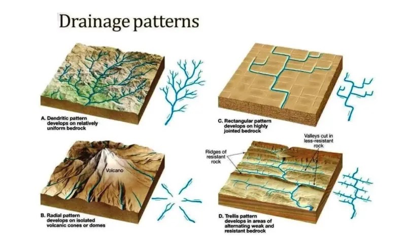
What is Radial Pattern?
Radial Patterns on isolated volcanic cones or domes
Looks like a flower and in the middle its the volcano

What is Rectangular Pattern?
Rectangular Pattern develops on highlt jointed bedrock
Looks very blocky!

What is Trellis Pattern?
Trellis patterns develop in areas of alternating weak and resistant bed-rock
looks blocky but has more lines across

Streamflow Characteristics: Streamflow Factors that determine velocity
Gradient or Slope
Channel Characteristics: shape, size, roughness
Streamflow Characteristics: What is Discharge
Volume of water flowing in the stream (generally expresses as cubic feet per second)
The work of running water: What is Erosion?
Erosion is the warrying away- removal of rock
the natural process where soil, rock, or land is gradually worn away and transported by agents like water, wind, or ice
The work of running water: What is Transportation?
Transportation is Transported Materials called Stream Loads
What are the three Stream loads?
Dissolved load
Suspended load
Bed load
*STUDY: 9.12 Transport of Sediment
Work of Running water: Load is related to a streams….
Competence and Capacity
competence: maximum particle size
Capacity: maximum load
Salt equals….
TDS!
Total Dissolved solids in water!
Capacity is related to….
Discharge!
Colorado River
Super steep, it has HIGH COMPETENCE (it can move big material). Also LOW CAPACITY.
Mississippi
LOW COMPETENCE (muddy and no boulders), and HIGH CAPACITY
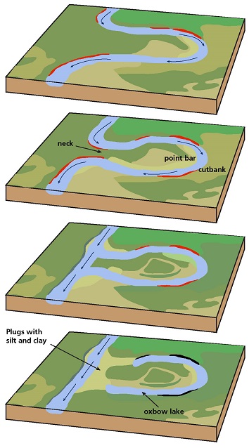
Work of running water: Deposition
Deposition is caused by a decrease in velocity
Competence is reduced
Sediment begins to drop out
a geological process where flowing water, having lost energy, drops transported sediment (sand, pebbles, soil)
Work of running water: Stream Sediments
Stream Sediments are known as alluvium
Well-sorted deposits
materials (sand, silt, clay, gravel) deposited by running water
Name the Stream Channels
Bedrock Channels
Alluvial Channels
Meandering Streams
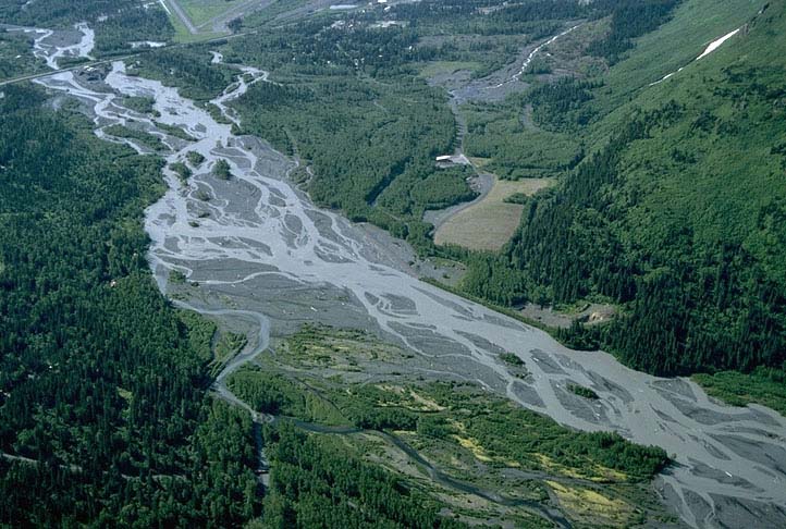
Braided Streams
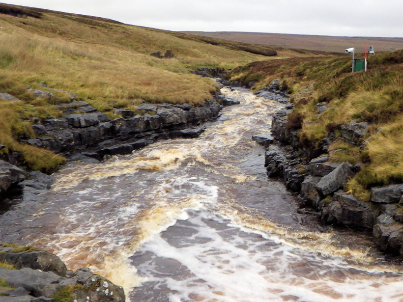
Bedrock Channels
Bedrock Channels cut into the strata (strata: parallel layers of sedimentary rock or soil deposited by natural forces)
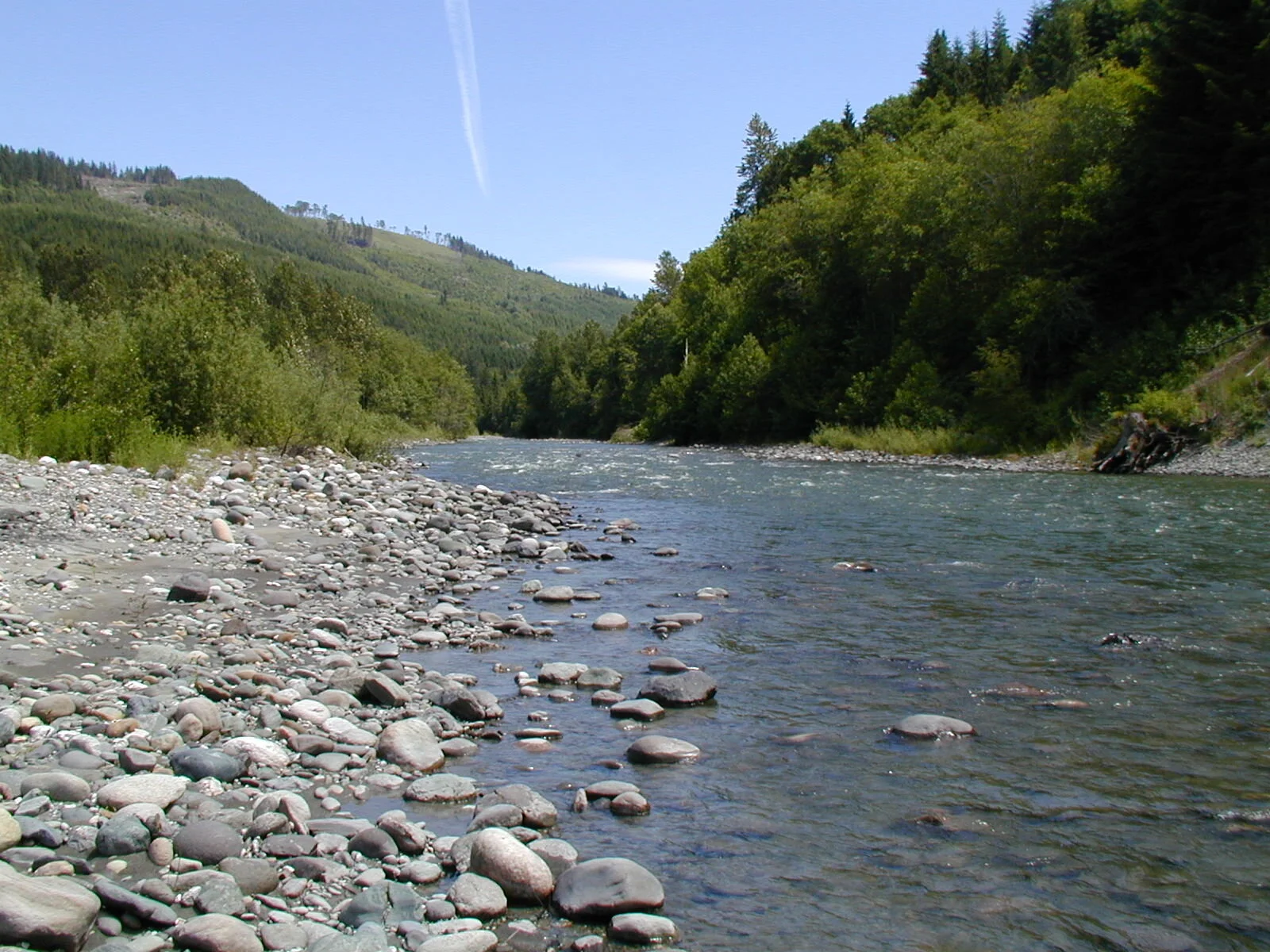
Alluvial Channels
Alluvial Channels are loosely consolidated sediment
a natural watercourse with a bed and banks composed of loose, erodible sediment (alluvium) transported by the stream itself
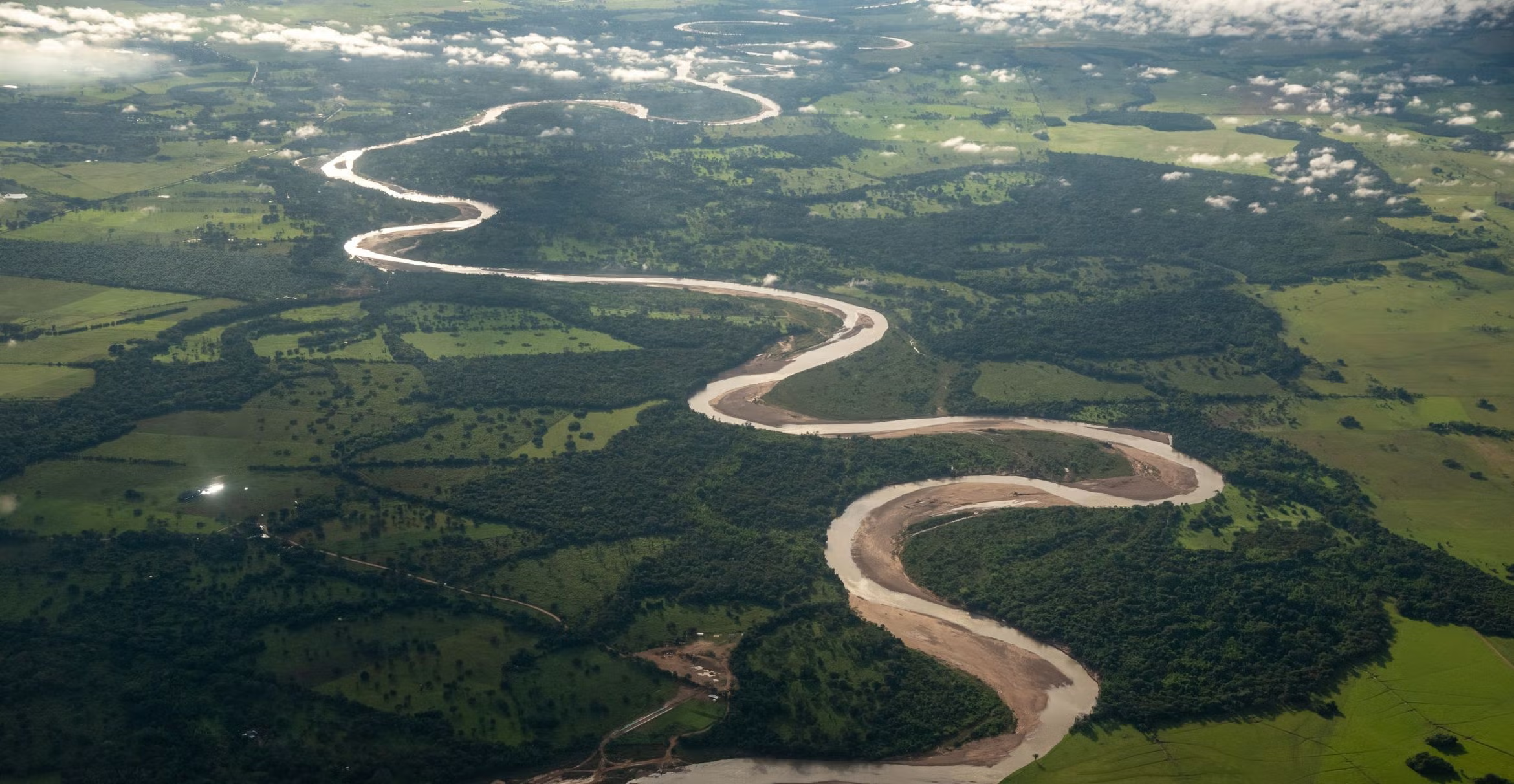
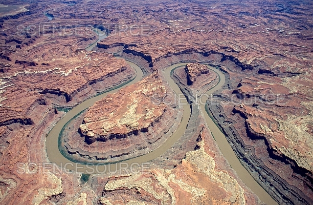
Meandering Streams
Meandering Streams move in sweep bends at a slow graduing pace
a single, sinuous channel that winds in snake-like curves
Braided Streams
Braided Streams are complex network of channels
Where does Deposition happen?
Any place it can!
deposition: the geological process where flowing water, losing kinetic energy, stops transporting sediment and drops materials like pebbles, sand, and mud, forming features like deltas and floodplains
Shaping stream valleys: Base Level
Base Level is the lowest point a stream can erode to
There are two General Types…
Ultimate: sea level
Temporary or local
Change in stream causes….
Readjustment of the stream - deposition or erosion
Rivers want to…..
flatten the earth
Shaping Stream Valleys: Valley Deepening
V-shaped
Downcutting base level
incised meanders
As land rises it can form incised meanders
Valley Deepning features
Rapids
Waterfalls
What river is a V shaped valley
Yellowstone
Shaping stream valleys: Valley Widening
Valley Widening are meandering streams
Stream is near base level
Downward erosion is less dominant
Stream energy is directed side to side
Shifting stream produces a broad flat valley floor of alluvium: floodplain
Meandering Streams
a single, sinuous channel that winds across4,5,6 flat terrain, characterized by high-velocity water eroding the outer banks (cut banks) and slow-velocity water depositing sediment on inner banks (point bars)
If land begins to uplift…..
incised meanders appear
Shaping Stream Valleys: Changing baseline can create….
Incised Meanders
Stream Meanders
Groundwater: Water beneath the surface
Surface pore spaces are saturated with water
Largest freshwater reservoir for humans
Geological Roles
As an erosion agent, dissolving by groundwater produces
sinkholes
caverns
an equalizer of streamflow
Distribution of water: Underground Zones
Belt of Zones
Zone of saturation
all pore spaces in the material are filled with water
water within the pores is groundwater
water table
Water Table
the upper limit of the zone of saturation

Unsaturated zone is not…..
saturated water
Unsaturated
air inside

Saturated
water inside
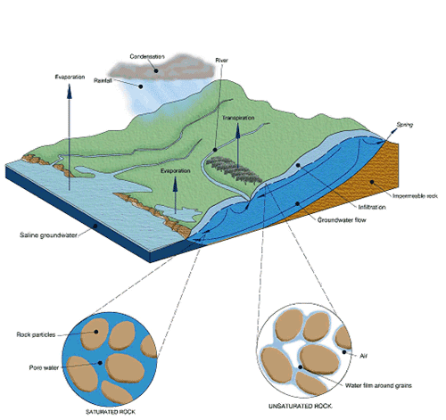
Aquitard
slow/stops the flow of water
a geological formation with low permeability—such as clay, silt, or unfractured rock—that restricts groundwater movement
Storage of Movement of Groundwater: Distribution of groundwater
Porosity
Permeability
Porosity
percentage of pore spaces
Determines storage of groundwater
Permeability
Ability to transmit water through connected pore spaces
Aquitard
Aquifier
Aquitard
an impermeable layer of material
slows, stops water when passing through
Aquifer
a permeable layer of material
Wells, Artesian Systems, and Springs: Wells
Pumping can cause a drawdown (lowering) of the water table
Can form a cone depression
Pumping can form a cone of depression in the water table
Wells, Artesian Systems, and Springs: Artesian wells
water in the well rises higher in the initial groundwater level
Must be confined to an aquitard
Flows freely
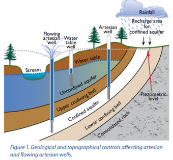
Artesian systems have….
Recharge Areas
water enters the groundwater system
Environmental Problem Related to Groundwater
Land subsidence caused by its withdrawl
Contamination