Meteorology - Exam 3 Combined
1/179
There's no tags or description
Looks like no tags are added yet.
Name | Mastery | Learn | Test | Matching | Spaced | Call with Kai |
|---|
No analytics yet
Send a link to your students to track their progress
180 Terms
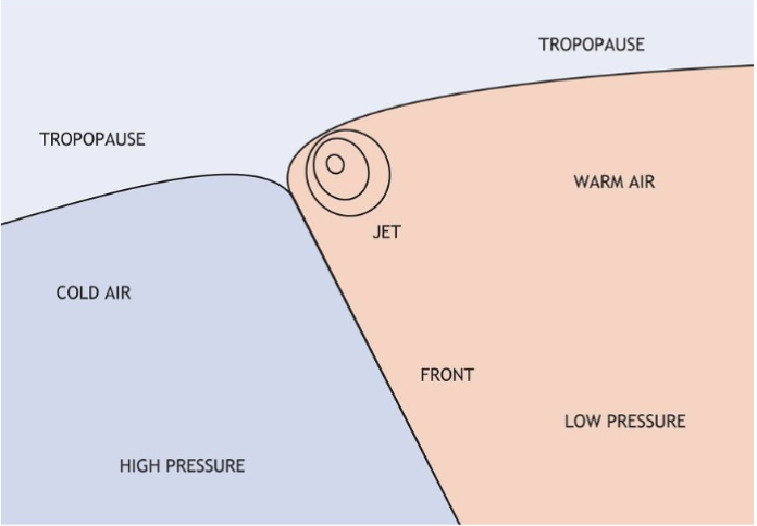
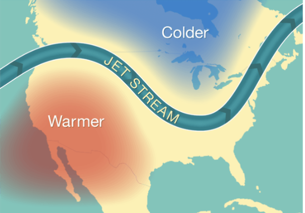
A ____ _____ is a flat tubular current of air, usually located near the tropopause
Jet Stream
Jet stream was discovered by _______ ____, whose regular weather balloon launches from Japan ended up flying out over the Pacific Ocean at a considerable rate.
Wasaburo Ooishi
Wasaburo Ooishi’s research identified strong-altitude westerly winds over _____
Japan
The jet stream blows from…
West to East
WWII ______ - ______ ________ _____ were launched in hopes to reach North America through the jet stream.
Fu-go balloon bombs
The US observed the jet stream by ________
Aircraft
Jet streams are _______ bands of strong winds with typical speeds of 100-200+ knots
Narrow
The minimum jet stream speed is ___ knots
60
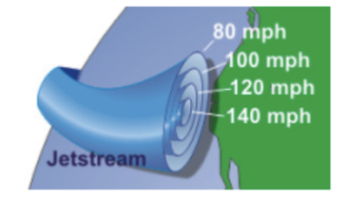
In a jet stream, winds are strongest near the center ( _____ ____)
Jet core
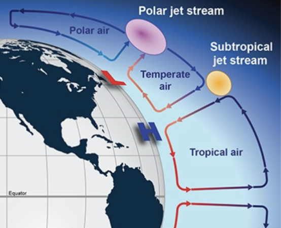
Earth has a total of 4 jet streams with 2 ____ jet streams and 2 _________ jet streams
Polar, Subtropical
Jet streams can also be called the _________ jets
Tropopause
Jet streams hang out at the ____ _____.
Cell break
The weaker of the jet streams are the ________, due to altitude and a less steep gradient.
Subtropical
Jet streams are _______ rivers of air
Discontinuous
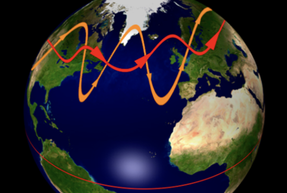
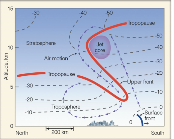
What is being shown by the RED line?
Zonal flow

What is being shown by the ORANGE line?
Meridional flow
T/F jet streams play only a small role in global heat transfer
False
The looping nature of the polar jet stream has an important role in the development of ___ - _____________ cyclonic storm
Mid-Latitude cyclonic
Jet streams are caused by the energy ________ that exists between high and low latitudes
Imbalance
Jet streams form when ____ air meets _____ air masses in the atmosphere
Warm, Cold
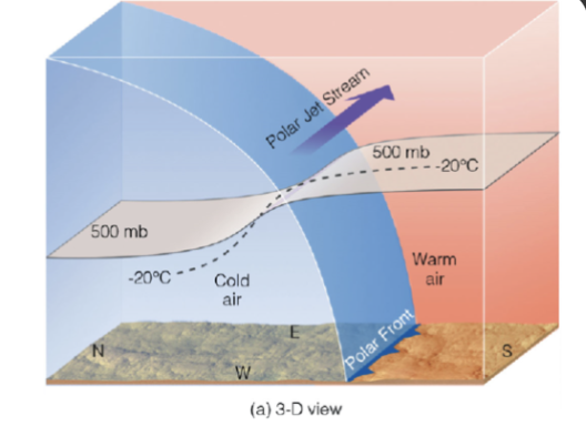
The greatest contrast in air temperature occurs along the _____ zone
Frontal
The jet stream is stronger in the _____
Winter
The jet stream follows the ___, as elevation increases seasonally
Sun
The subtropical jet stream sits between the _______ and ______ cell
Hadley, Ferrel
The polar jet stream sits between the _______ and ______ cell
Polar, Ferrel
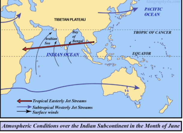
A seasonal ____ jet forms above southeast Asia, India, and Africa
Baby
___________ of ocean water provides the atmosphere with surplus water that falls as precipitation.
Evaporation
Storms produce _____ that blows over oceans creating waves and currents
Winds
______ can modify the weather and climate of a region by bringing in vast quantities of warm or cold water.
Currents
_______ are surface currents that move water in the ocean
Gyres
Gyres move _______ in the northern hemisphere
Clockwise
Gyres move _________ in the southern hemisphere
Counter-clockwise
The boundary separating two masses of water with contrasting temperatures and densities is called an _______ ____.
Oceanic front
INCOMPLETE When oceanic fronts meet, a portion of the boundary current
INCOMPLETE Eddy
The _____ stream warms waters on the East coast
Gulf
The ________ current cools the water on the west coast
California
______ spiral results from wind blowing surface waters and moving water beneath with depth due to Coriolis force
Ekman
The net transport of surface water is called the _______ _______
Ekman transport
During __ ____ , surface water temps across much of the Eastern tropical Pacific rises by at least 0.5C for periods of a few months to a year or more.
El Nino
During El Nino, the trade winds reverse, sending warm water _______
Eastward
__ ____ features a strengthening of the trade winds
La Nina
Frequency of hurricanes _______ in the North Atlantic during El Nino
Increases
An ____ ____ is a widespread body of air with the same-ish temperature and same-ish humidity value
Air mass
2 things that characterize air masses
Temperature
Humidity
A ______ _____ is a region where air masses originate and acquire their homogenous traits
Source region
Midlatitudes are not source regions because there are frequent _______ , causing mixing in the air
Storms
For an air mass to form, its source region must be generally ______ and uniform ______
Flat, composition

2 warm source regions
Sahara desert
Tropical oceans
4 cold source regions
Arctic Ocean
Siberia
Northern Canada
Southern Ocean
Moisture distribution is distinguished as _______ ( c ) and __________ (m)
Continental, Maritime
Air masses are designated first as _______ (T), _____ (P), and __________ (A)
Tropical, Polar, Arctic or Antarctic
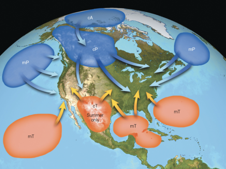
North American air masses:
Continental polar*
Continental arctic*
Continental tropical (summer only)
Maritime polar*
Maritime tropical
________ can act as a barrier of air masses
Mountains
Cold weather that impacts the US in winter is from the ________ ______ and ________ ______ air masses
Continental polar, continental arctic
The winter air masses usually bring ______ weather
Calm
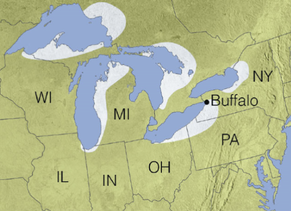
Lake effect snow mainly impacts which bodies of water?
Great Lakes
When an air mass moves over a large _____ __ _____, its properties can change.
Body of water
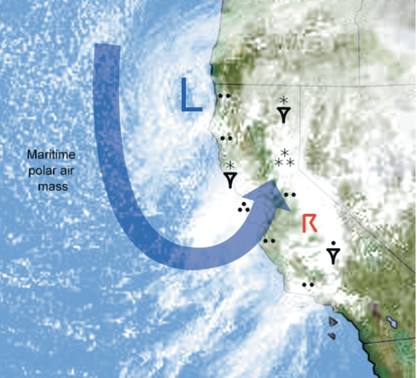
________ _____ (mP) air mass moves inland where coastal mountains force it to rise, condense, and drop rain
Maritime Polar
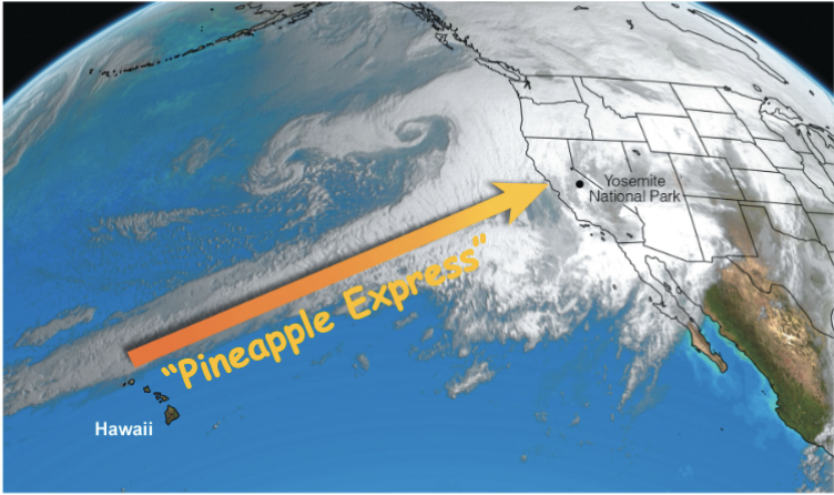
Maritime Tropical (mT) air masses can sometimes cause an atmospheric condition called _________ ________
Pineapple Express
The Pineapple express is one example of the feature known as _______ _______ (AR)
Atmospheric river
_______ are transition zones between two air masses of different densities.
Fronts
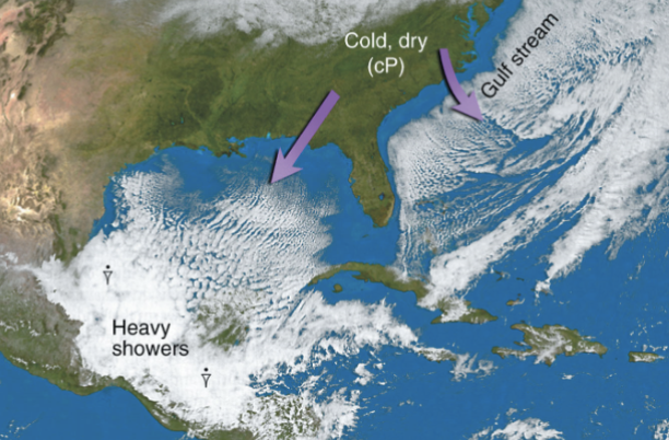
_______ fronts are associated with cold dense air with a frontal zone that can extend up to 5km
Polar
_______ fronts are associated with very cold denser air but with a frontal zone that ay only extend to 1 to 2km
Arctic

What front is shown?
Cold

What front is shown?
Warm

What front is shown?
Stationary

What front is shown?
Occluded
In a stationary front, cold air is on the ______ side and warm air is on the ______
Right, left
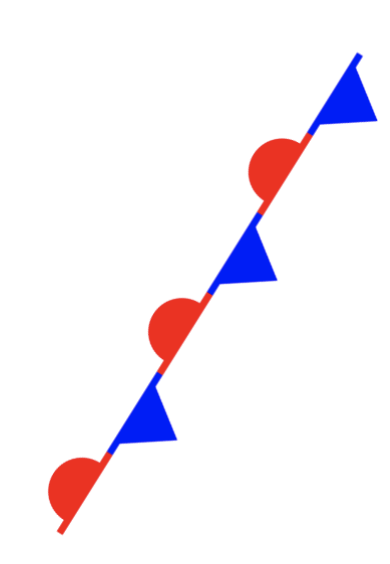
In an occluded front, 2 types are possible. A ____ type and a ______ type
Cold type
Warm type
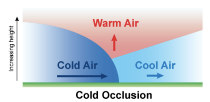
Occurs when a fast-moving cold front overtakes a slower-moving warm front, lifting the warm air mass completely off the ground
Cold Occlusion
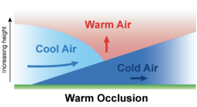
Occurs when the air ahead of a slow-moving warm front is colder and denser than the air behind a catching-up cold front
Warm Occlusion
_________ are boundaries where there are steep horizontal changes in moisture-separate moist from dry air
Drylines
______- ______ fronts form when the tropopause dips downward amd folds under the polar jet stream.
Upper-Air Fronts
What service is responsible for making the weather maps?
National Weather Service (NWS)
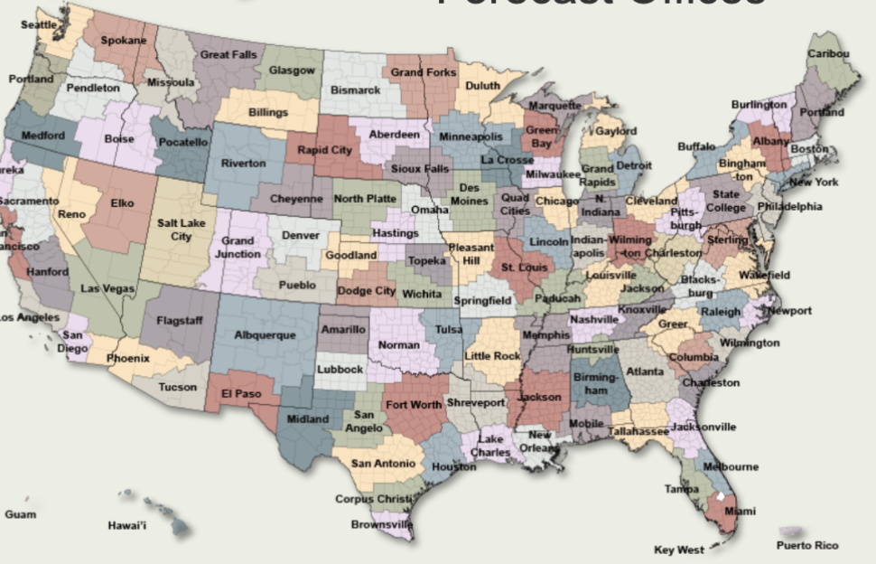
There are ___ NWS Weather Forecast Offices
112
The ________ ______ __ _________ ______ (NCEP) collects weather data from all over the world.
National Centers for Environmental Prediction
The NCEP is composed of _ distinct centers
9
The _______ ____________ ______ (WPC) mostly handfles everyday weather like fronts and temperatures.
Weather prediction center
The ________ _______ _____ (SPC) handles severe thunderstorms and fire-weather outlooks.
Storm Prediction center
The ________ ________ ______ (OPC) offers detailed weather analyses across the Atlantic, Pacific, and Arctic oceans.
Ocean Prediction Center
The _________ ________ _______ (WMO) is responsible for the international exchange of weather data. They are also a part of the United Nations (UN)
World Meteorological Organization
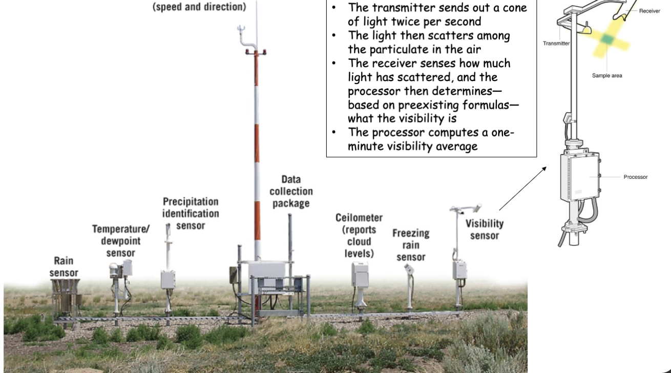
The _______ ________ _______ ______ (ASOSs) report basic weather elements
Automated Surface Observation Systems
The _________ _______ _______ ______ (CWOP) is a private-public partnership where citizens can collect weather data
Citizen Weather Observer Program

What is being shown?
Station Plot
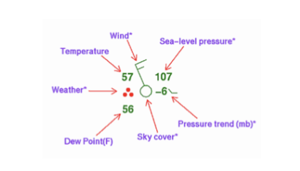
How do we read pressure on a station plot?
We add a “10” to the front and a decimal point before the last digit.
Ex: 107 = 1010.7
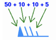
How do we read wind on a station plot?
Each line represents a number and we add them. Direction is determined by whichever way the arrow points.
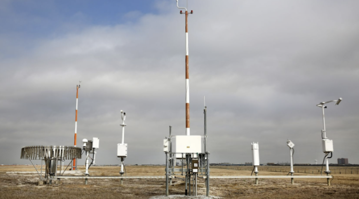
Conditions aloft are read by launching _______ _____, which is done TWICE a day by each of the 112 weather stations.
Weather balloons
Weather balloons are launched twice daily at midnight and noon ________ _____ time.
Greenwich Mean
2 types of weather maps
Surface maps
Upper-air maps
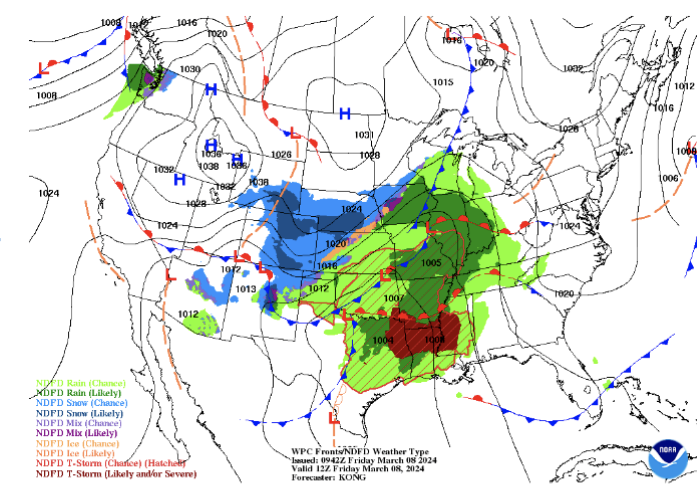
What type of weather map is shown here?
Surface Map
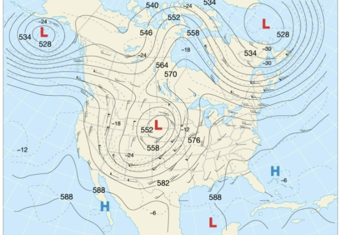
What type of weather map is shown here?
Upper-Level Map
Surface map data is read from stations close to the ground, commonly located at every ________
Airport
In the northern hemisphere, HIGH pressure rotates ________
Clockwise
In the northern hemisphere, LOW pressure rotates _________ ________
Counter-clockwise
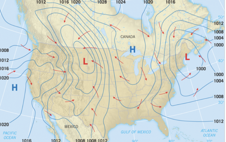
Pressure is represented on a surface map by _________
Isobars
_______ are defined as a local storm produced by a cumulonimbus cloud and MUST HAVE thuder and lightning
Thunderstorm
Severe thunderstorm ingredients (SLIM)
Shear
Lift
Instability
Moisture
_______ is the rate at which wind velocity changes from point to point
Shear
3 types of shear
Speed shear (only speed changes)
Directional shear (only direction changes)
Combination (both change)
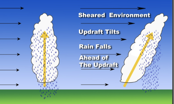
Speed shear is very important for severe thunderstorm development as it tilts the ________ (rapidly rising air that forms clouds)
Updraft