WOODY PLANTS FINAL OH GOD HELP ME
1/59
Earn XP
Description and Tags
um so basically there are 16 lectures and we don't have slides for 2 of them and i haven't heard a word zimmy has said for the past 3 months
Name | Mastery | Learn | Test | Matching | Spaced | Call with Kai |
|---|
No analytics yet
Send a link to your students to track their progress
60 Terms
Anthropogenic Plant Communities
An assemblage of plant populations shaped primarily by human disturbance rather than previous ecological process
Develops in urban, suburban, and rural conditions
Anthropogenic Plant Communities Key Characteristics
Occur in disturbed soils
Dominated by stress tolerant species
Often has non-native species
CSR Model
C = Competitors
S = Stress tolerators
R = Ruderals
Urban Metabolism
Flow of energy, materials, water, nutrients, and organisms through a city, similar to how metabolism flows through living organisms
Urban Soils
Anthrosols = human-altered soils
Shallow soil horizons
Altered pH
Increased runoff
Urban Hydrology
Channelized stream increase flow velocity (urban stream syndrome)
Altered by impervious surfaces
Stormwater infrastructure moves water off site instead of permeating through soil
Drought stress for plants
Urban Atmosphere
Urban heat island effect
Increased rainfall due to rising warm air (creates microclimates)
Air has elevated levels of nitrogen oxides, ozone, and particulate matter
Rules of 10s
10% of important species escape cultivation
10% of escaped species establish
10% of established species become invasive
Only about 1 in 1000 introduced species become invasive
History of Northern Successional Forest
ICE AGE MADE DECIDUOUS BROADLEAF FORESTS
AFTER THIS FIRE WINDER FLOODING AND BEAVERS DISTURBED FORESTSIN THE U.S.
These disturbances let successional forests happen
Before European settlement, 90% of land was forest
By the 1800s, 70% converted to fields
Early 1900s, fields abandoned and grow into mature forests
These forests are MODIFIED successional forests
Presently challenged by invasives, deer, fragmentation, and no disturbance
Makeup of Northern Modified Successional Forest
Degraded by invasive species
Dense shrub, vine, and herbaceous layers
Chaotic structure
Makeup of Northern Modified Successional Forest After Disturbance
Four Stages
Stand initiation: woody generalists
Stem exclusion: canopy closes, growing space occupied by trees / woodies
Understory reinitiation: shrubs and herbaceous plants occupy the ground layer
Old growth / mature forests
Elk Neck State Forest
Formerly agriculture for European settlements in the early 1700s. After this, it was harvested for charcoal for iron furnaces until the early 1900s when it matured into the forests that we have today
Mesic Mixed Hardwood Forests
They develop on acidic and nutrient poor soils
Often on ravines or slopes (or undulating uplands)
Coastal Plain Oak-Pine Forests
Dry fire prone woodlands
Sandy and gravely soil
Steep slopes, north facing bluffs, dunes, and terraces
Mainly made of oaks
Coastal Plain Pitch Pine Forests
Dry mixed woodlands
Flat or gently rolling uplands
Considered an extension of the New Jersey Pine Barrens
Disturbed by fires
Pinaceae and Fagaceae (canopy)
Ericaceae (understory)
Coefficient of Conservation
Measurement used mainly for wildflowers
1 = very common generalist
10 = very rare habitat restricted plant, dependent on unmodified habitats
Eco-tone
Transition zone between two habitats
Management of Forests
Invasive species suppression
White-tailed deer management
Replanting native trees / shrubs
Prescribed fire
Threatened species protection
Grassland definition
“Any natural community or ecosystem in which the herbaceous layer is dominated by grasses, other graminoid (grass-like) plants, such as sedges and include associated forbs (other herbaceous flowering plants)”
Process of a Grassland
Because of succession, there has to be periodic disturbances to keep it a grassland and not have trees
History of Eastern Meadows / Grasslands
Tens of millions of acres prior to settlement (10% of grasslands remain)
Eastern different than Midwest because Eastern grasslands were not affected by the last ice age
Historically most eastern grasslands were not recorded because they settled quite quickly (due to a lack of trees)
Prairies
Mid to tall grasses
Deep hydric soil
Lack of trees
Historically disturbed by fire, drought, and herbivores
Savannas
Dense grass layer, sparse tree canopy
Deep hydric soils
Rolling hills
Disturbed by fire
Barrens
Short to mid grasses
Shallow rocky soil
Exposed rock
Caused by extreme conditions
Disturbed by fire
Glades
Short to mid grasses PLUS succulents & bryophytes
Thin hydroxeric soils
Often within forest groves
Balds
Short to mid grass
Moist soil
Often above 5,500 feet
Often surrounded by shrubs
Disturbed by climate, grazing, fire, HUMANS
Riverscours
Patchy short to mid grass
Sandy hydroxeric soil
Exposed bedrock
Shaped by flooding and stream currents
Vegetation must be tolerant of sediment movement
Meadows
Mid to tall grass
Lots of flowers
Found in floodplains
Deep and saturated soil
Disturbed by beaver floods…
Fens
Mid to tall grass
Found in floodplains
Fed by ground water
Basic peat soils
Disturbed by fire and flood
Montane Bogs
Peat moss DOMINATES this. (sedges and rushes are cucks)
Found in forest groves
Fed by rain water
Disturbed by fires, floods… AND beavers.
Depression Ponds
Submerged and floating aquatics and grass like plants
Seasonal or permanent water bodies
Found in forest groves
Disturbed by flooding
Delaware Grassland Communities
Upland Switchgrass
Successional Broomsedge
Little Bluestem Field
Serpentine Barrens (ecology)
A barren where the ecology is dominated by Serpentinite
VERY thin, infertile soils (toxic to many plants)
Unique flora because of this
Serpentine Barrens (history)
Mined for chromium and feldspar
Not used for farming during colonization because of toxic soils
State Line Serpentine Barrens are the last major Serpentine Barren in the Eastern US
European settlers suppressed fire which negatively impacted it, currently managed with prescribed fires
The Piedmont Province
Plateau region in Eastern US between Atlantic Coastal Plain and Appalachian Mountains
The border between the Coastal Plain and Piedmont is called the Fall Line
Goes from New York to central Alabama
Rolling hills, 200-1,000 FASL (feet above sea level)
Crystalline metamorphic and igneous rocks, often exposed
Communities in the Piedmont Province
Rich uplands / terrestrial forests
Floodplains
Groundwater seepage wetland
The Coastal Plain Province
Flat, highest is 100 FASL
From Cape Cod to Florida, west through the Gulf Coast, to east Texas
Formed from sediments eroded from the Piedmont Mountains
Sediments have deposits of sand, silt, and gravel
Communities in the Coastal Plain Province
Forested wetlands
Atlantic white cedar swamps
Bald cypress swamps
Seasonally flooded wetland depressions
Freshwater tidal rivers and marshes
Inland sand dunes
Atlantic maritime habitats, beaches, dunes
Maritime woodlands
Tidal salt marsh
Salt panne
Salt shrub zone
Pennsylvania Plant Species
Over 3100 plant species in PA
Flowering plants
-1900 native
-1200 non-native
25 conifers
100 ferns
Currently 496 special concern PA plants
232 endangered plants
78 threatened
39 rare
148 undetermined
2 federally endangered
Goat Hill Historical Land Use
Fire and grazing until 1940
Mining 1800s
(citizens saved it from being a quarry)
Settlement 1700s
Native Americans created fires to maintain grasslands
Wetland
Hydrophytic plants
Hydric soil
Seasonal or permanent water saturation
Wetland Systems
Marine
Estuarine
Riverine
Lacustrine
Palustrine
Marine Wetlands
Open ocean and associated high-energy coastline
Extends from outer edge of continental shelf shoreward to one of three lines
Subsystems
-Subtidal
-Always covered with tidal water
-Intertidal
-Tide goes in and out
Marine systems and what species are where in the system are heavily influenced by tidal energy
Estuarine Wetlands
Tidal habitats that are semi enclosed by land but have access to the ocean
Ocean water is usually diluted by freshwater runoff (salinity variation)
Subsystems
-Subtidal
-Always covered with tidal water
-Intertidal
-Tide goes in and out
Includes estuaries and lagoons
Low energy wave action
North Atlantic Salt Marsh
Community of Estuarine Wetlands
At shores of coves and bays
Strongly influenced by saltwater from multiple daily floodings, this means the plants must be well adapted
Known for having lots of biomass (especially unseen roots and rhizomes)
Organic peat substrate
Typical Profile of North Atlantic Salt Marsh
Low, regularly flooded marsh with heavily salt tolerant grass
Higher, irregularly flooded marsh with less salt tolerant grass
Low hypersaline pannes with glassworts
Salt scrub ecotone with shrubs
Ecosystem Services of North Atlantic Salt Marsh
One of the most productive and valuable ecosystems in the world
Store water and nutrients
Slow waves and wind
Provide habitat
Valuable
Habitat Degradation of the North Atlantic Salt Marsh
Being lost to human development, sea level rise, and erosion
Estimated that fringing salt marshes of Delaware will be gone in two to three centuries
Woodland Beach Wildlife Area
Land started getting bought in 1950s
Oldest wildlife area in DNREC fish and wildlife
Combination of hunting, fishing, and nonconsumptive use
Three main areas:
-Upland forest
-Early/mid successional habitat
-Salt marsh
Upland Forest
An area of the Woodland Beach Wildlife Area
Deciduous hardwood canopy
Shrub berry understory
Managed by felling trees
Prescribed fires
Mortification
-Kill trees with girdling or herbicide application
Big machines to mulch and mow
So pretty much they’re racist against deer in some areas to prevent over browsing pretty much
Early Successional Habitat
An area of the Woodland Beach Wildlife Area
Managed for the Northern Bobwhite that needs 4 types of cover: nesting, brooding, woody escape, and winter thermal
Prescribed fire 1-3 years
Ground disturbance to remove woody masses and increase brood habitat
Salt Marsh
An area of the Woodland Beach Wildlife Area
Makes up most of the landscape at Woodland Beach Wildlife Area
Marsh helicopter
Marsh MASTER
Sea level rise is a huge issue
Riverine Wetlands
Rivers
All water habitats within a channel with two exceptions
-Water habitats dominated by trees, shrubs, emergents
-Water habitats with ocean-derived salts of 0.5 ppt or greater
On either side of the channels there are trees / shrubs
Stops being riverine when it stops being a channel (duh)
Four Subsystems of Riverine Wetlands
Tidal
-Extends from the upstream limit of tidal fluctuations down to the upper boundary of the Estuarine System. The stream bottom is mainly mud with occasional patches of sand. The floodplain is typically well developed.
Lower Perennial
-Characterized by a low gradient. There is no tidal influence, and some water flows all year, except during years of extreme drought. The substrate consists mainly of sand and mud. The floodplain is well developed.
Upper Perennial
-Characterized by a high gradient. There is no tidal influence, and some water flows all year, except during years of extreme drought. The substrate consists of rock, cobbles, or gravel with occasional patches of sand. Very little floodplain development.
Intermittent
-Channels that contain flowing water only part of the year. When the water is not flowing, it may remain in isolated pools or surface water may be absent.
Lacustrine Wetlands
Lakes
Water habitats with the following characteristics:
-Always in a depression (or dammed river channel)
-No trees, shrubs, emergents
-At least 8 hectares (20 acres)
<0.5 ppt salinity
Two subsystems
-Limnetic: Deepwater habitats, depth of >2.5m
-Littoral: Wetland habitats, max depth of 2.5m
Palustrine Wetlands
Marshes, swamps, bogs, fens, wet prairies, ponds
Often occur as islands within lakes or rivers
All nontidal wetlands dominated by trees, shrubs, and emergents
But oh wait nvm it also includes wetlands without such vegetation as long as it has these 4 following characteristics:
-Area less than 8 hectare (20 acres) (1st difference from lacustrine if no vegetation)
-Lacking active wave-formed or bedrock shoreline features (2nd difference from lacustrine if no vegetation)
-Water depth is <2.5m
-Salinity is <0.5 ppt
Wetland Plant Classifications
Indicator
-Definition
-Rate of Occurrence in Wetlands Only
Obligate (OBL)
-Occurs almost always in wetlands in natural conditions
-99%
Facultative Wetland (FACW)
-Usually occurs in wetlands but occasionally found elsewhere
-67-98%
Facultative (FAC)
-Equally like to occur in wetlands and non-wetlands
-34-66%
Facultative Upland (FACU)
-Usually occurs in non-wetlands, but occasionally found in wetlands
-1-33%
Upland (UPL)
-Almost always occurs in non-wetlands
-<1%
Mid-Atlantic Coastal Plain Depression Swamp Forest
Palustrine wetland
Diverse group of poorly-drained basin wetlands
Flat Coastal Plain terraces
Even forest stratification layers
Franklin Delano Roosevelt (FDR) Park
In Philly, upriver from salt front
Lenape peoples
Was marsh and meadow until heavy alterations in 1900s
Tons of human development disturbances through the 1900s
Currently being recovered / restored
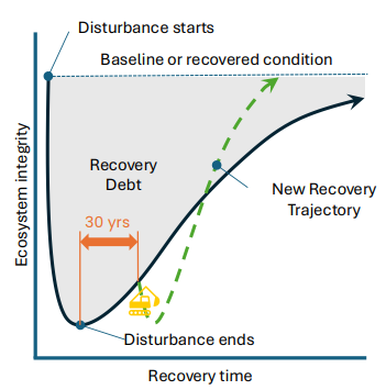
Ecological Recovery in Context
Recovery debt
-Interim reduction of biodiversity and biogeochemical functions occurring during ecosystem recovery
Disturb with purpose
Steepen the recovery trajectory