River Landforms And Processes
1/70
There's no tags or description
Looks like no tags are added yet.
Name | Mastery | Learn | Test | Matching | Spaced | Call with Kai |
|---|
No analytics yet
Send a link to your students to track their progress
71 Terms
Erosion
The wearing away and removal of rocks from cliffs, river beds and banks
Weathering
The wearing away of rock in its original place
Chemical Weathering
The decomposition of rock caused by a chemical change within that rock as a result of weak acids in rain or sea water
Freeze Thaw Weathering
Water gets into the cracks of rocks, freezes and melts repeatedly as temperatures change, resulting in the weakening and breaking away of the rock. This is an example of mechanical weathering
Abrasion
The wearing away of rock by sediment scraping against it like sandpaper
Attrition
Erosion caused by rocks and boulders transported by water hit eachother and breaker into smaller, rounder pieces
Deposition
Occurs when material being transported by the water is dropped due to the water losing energy
Transportation
The movement of eroded material by water
Hard Engineering
The use of concrete and large artificial structures to defend land against natural erosional processes
Soft Engineering
Managing erosion by working with natural processes to help restore natural landscapes
Mass Movement
The downhill movement of weathered material under the force of gravity
Long Profile
The gradient of a river from its sourse to its mouth
Cross Profile
The side to side cross section of a river channel and/or valley
Lateral Erosion
Sideways erosion by a river on the outside of a meander channel
Vertical Erosion
Downward erosion of a river bed
Solution
Soluble particles are dissolved into the river and carried by the water
Saltation
Particles bouncing down a river bed
Traction
The rolling of boulders and pebbles along a river bed
Suspension
Fine solid material held in the water while the water is moving
Discharge
The quantity of water that passes a given point eithin a given period of time
Estuary
The tidal mouth of a river where it meets the sea, wide banks of deposited mud are exposed at low tide
Flood Plain
The relatively flat area forming the valley floor on either side of a river channel, which is sometimes flooded
Describe interlocking spurs
They are projections of highland that alternate from either side of a valley and are formed by fluvial erosion
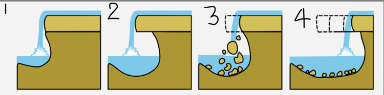
1?
Waterfalls occur when a band of hard rock overlies a softer rock. Falling rock and water particles erode the soft rock below creating a plunge pool

2?
The soft rock is undercut by erosional processes such as hydraulic action and abrasion creating a plunge pool where water and debris swirl around eroding the rock through corrosion further deepening it and creating an overhang

3?
Hard rock overhang above the plunge pool collapses as its weight is no longer supported

4?
Erosion continues and the waterfall retreats upstream leaving behind a gorge
Rapids
Fast flowing, turbulent sections of a river
Name two landforms found in the middle course
Meanders
Oxbow lakes

A?
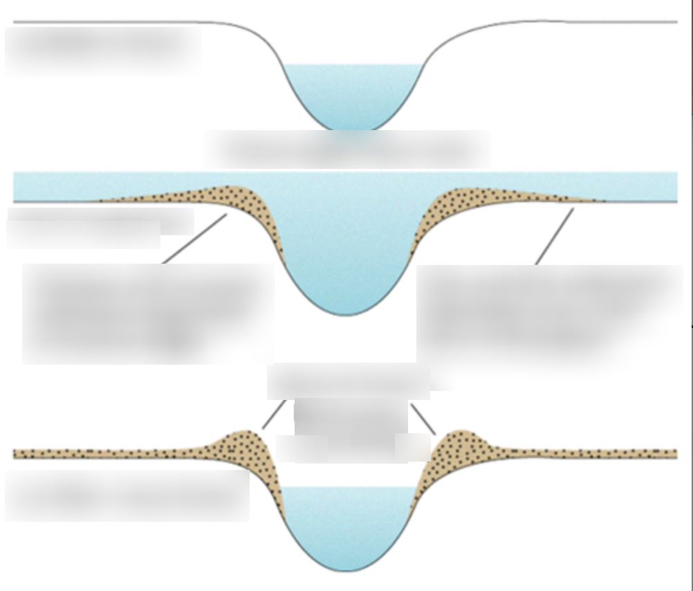
Fast flowing water on the outside bank causes lateral erosion through abrasion and hydraulic actio, which undercuts the bank to form a river cliff
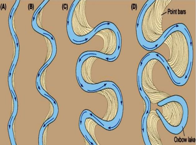
B?
The current is slower on the inside bend because the river channel is shallower (more friction). Eroded materials are deposited on the inside bend forming slip off slopes

C?
Over time curves increase due to erosion on the outside banks and deposition on the inside, slowly moving the position of the river

D?
Oxbow lakes are formed by old meanders that have curved so far that when there is very high discharge the water cuts across the neck and eventually cuts of the meader
Name 3 landforms from the lower course
Levees
Floodplains
Estuary
Describe the formation of a levee in four stages
Sediment that has been eroded further upstream is transported downstream. When the river floods, friction with the land reduces velocity and causes deposition

2?
Heavy sediment is deposited closest to the river. the size of sediment gets progressively smaller with increased distance from the river

3?
After many floods, the sediment builds up to increase the height of the river banks meaning that the channel can carry more water and flooding is less likely
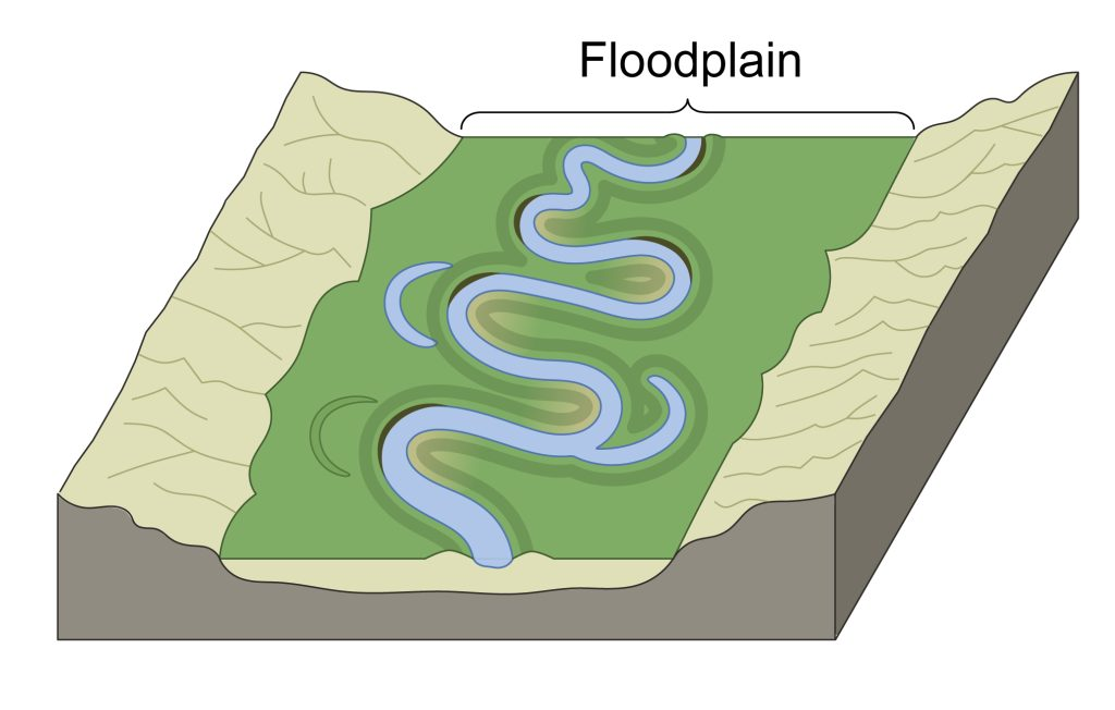
Describe the formation of a floodplain in three stages
During a flood water containing large quantities of silt pours out over the valley

Stage 2 of a floodplain formation?
The water slowly soaks away leaving behind the deposited sediment. The height of the floodplain increases as material is deposited on either side

Stage 3 of a floodplain formation?
Repeated flooding forms a thick silt deposit which is fertile and often used for farming
Give 5 characteristics of estuarys
Tidal part of a river where freshwater meets with salt water
Hight tidal range
Very wide
Mudflats - visible at low tide, some mud covered by salt marshes
Tidal bores - huge waves that funnel up the river
What is the path of a river as it flows downhill called?
Its course
What does the long profile of a river look like?
A steep upper course, a gently sloping middle course and an almost flat lower course
What does the long profile of a river show you?
How the gradient changes
What do rivers form as they flow downhill?
Channels and valleys
What do rivers do to the landscape?
Erode the landscape and transport eroded material to somewhere further along the course, where it is deposited
Why does the shape of the valley change along the river?
Depends on whether erosion or deposition is the dominant process
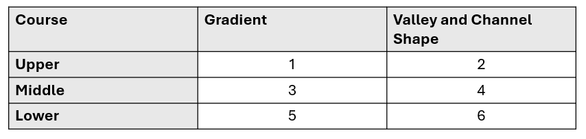
1?
Steep

2?
V-shaped valley, steep sides. Narrow, shallow channel

3?
Medium

4?
Gently sloping valley sides. Wider, deeper channel

5?
Gentle

6?
Very wide, almost flat valley. Very wide, deep channel
Why might a river deposit material?
Volume of water falls, the amount of eroded material increases, the water is shallower, the river reaches its mouth

Step 1 of interlocking spurs formation
In the upper course of a river, most erosion is vertically downwards. This creates steep, v-shaped valleys
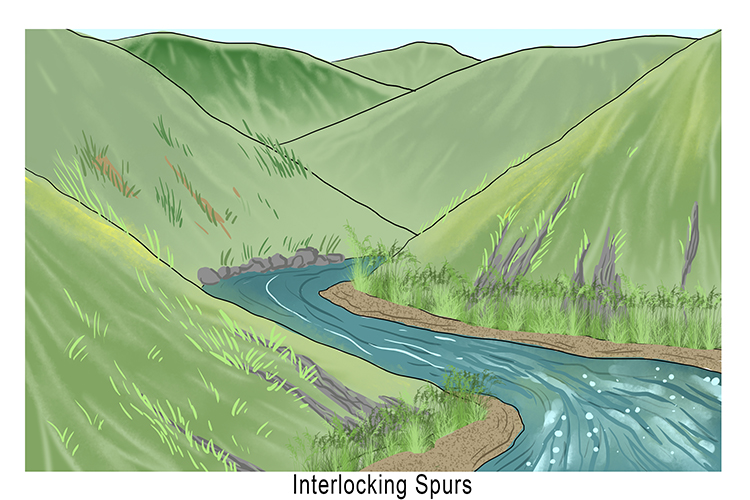
Step 2 of interlocking spurs formation
The rivers lack power to erode laterally, so they have to wind around the high hillsides that stick out into theirs paths on either side

Step 3 of interlocking spurs formation
The hillsides that interlock with each other as the river winds around them are called interlocking spurs

Step 1 of the formation of an estuary?
Estauries are founf at river mouths. The land is close to sea level and the river valley is at its widest
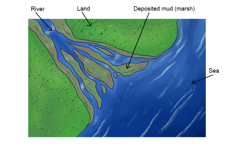
Step 2 of the formation of an estuary?
The water here is tidal - the river level rises and falls each day

Step 3 of the formation of an estuary?
When the water floods over the banks of the river, it carries silt and sand onto the valley floor

Step 4 of the formation of an estuary
As the tide reaches its highest point, the water moves slowly and has little energy, so it deposits sediment

Step 5 of the formation of an estuary?
At low tide, the wide, muddy banks are exposed
How can contour lines be used to tell the direction the river flows?
A river flows from higher contour lines to lower ones
How can you identify the upper course of a river on a map?
Identify waterfalls which will be marked on the map, high land, river crosses a lot of contour lines over a short distance, the river line is narrow
How can you identify the middle course of a river on a map?
Low nearby land, doesn’t cross many contour lines (gently sloping), meanders, the river line is wide