L15 Mountain permafrost and climate II
 Call Kai
 Learn
Learn Practice Test
 Spaced Repetition
 Match
Match Flashcards
 Knowt Play
1/16

There's no tags or description
Looks like no tags are added yet.
Name | Mastery | Learn | Test | Matching | Spaced | Call with Kai | Chat |
|---|
No analytics yet
Send a link to your students to track their progress
17 Terms
What factors contribut to extreme spatial variability in surface and near surface characteristics/properties of the sediment routing system?
Elevation;
Surface micro-climatology;
Subsurface material thickness and composition;
Water availability (and temp); and
Snow cover.
What are the impacts of changing snow cover and ground temperatures in mountain environments as a result of climate change?
Higher incidence of hazards such as rockfalls. Warm permafrost is also highly susceptible to warming → can trigger avalanches due to destabilisation. Detachment zones are generally located on margins of permafrost.
What is a case study for permafrost and destabilisation of alpine rock walls?
Summer 2003
Exceptional rockfall seen in the Alps throughout the summer of 2003 (approx > 3 degrees c warming);
There were fast thermal reactions of the subsurface of steep rock, which led to subsequent destabilisation of ice-filled discontinuities; and
Rockfall may be a direct consequence of this unexpectedly fast climate change.
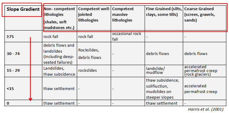
How can hazards related to mountain permafrost degradation be classified?
What are three summary points for part A?
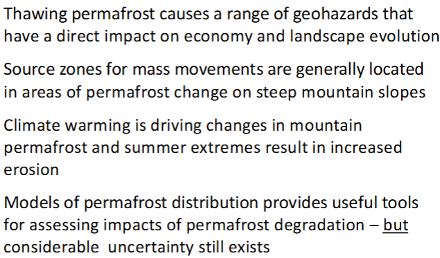
Thawing permafrost causes a range of geohazards that have a direct impact on economy and longer-term landscape evolution;
Source zones for mass movements are generally located in areas of recent surface ice loss and/or permafrost degradation and transition on steep mountain slopes; and
Slope angle and lithology are important controls on the types of mass movements and geohazards.
What occurred during the Kolka/Karmadon rock avalanche of 2002?
100 million m3 of ice and debris fell on to the Kolka glacier tongue shearing off the front of the glacier before crossing the Maili glacier;
Travelling at 100 km h-1 (speeds up to 300 km h-1);
Run-out approximately 18 km from the source → 80 million m3 of ice and debris were deposited;
Mudflow approximately 300 m wide continued for another 15 km down the confined valley;
125 people killed;
Debris dammed lakes- over 10 million m3 in volume;
Two similar but smaller events from the same mountain slope occurred in 1902; and
Extreme length of runout is probably due to the large amounts of glacier ice entrained in the debris.
What were the primary vs. secondary hazards in the 2002 case study?
Primary → avalanche; and
Secondary → debris/ice damned lakes.
What are four summary points for part B?
Lots of case studies in this part - can refer to if needed.
What is one example of how society has been (and will continue to be) impacted by mountain change?
Development in mountainous regions is going to be significantly compromised by changing climates. One example of this is mountain hydrology. Current estimates of climate change scenarios predict that there will be rapid acceleration of glacier retreat, decrease in snowfall, and decrease in snowmelt discharge. Artificial snow production across the Alps and hydropower in Switzerland will be affected.
What is the case study for societal impacts of mountain environmental change?
1987 floods - Switzerland.
What are the difficulties in determining the hazards of geomorphic processes?
Recognising processes and causal mechanisms;
Characterising event timescale and frequency; and
Accurately mapping the occurrence of phenomena.
How do cantons produce reigsters of hazard types and maps of hazard areas (in Switzerland following the 1987 floods)?
Hazard identification;
Hazard assessment; and
Risk management and land use planning.
Hazard maps are designed to show colour-coded danger zones.
Are hazard maps static?
No - they are dynamic, as the nature of hazards will evolve with changing climates, causing danger zones to be altered.
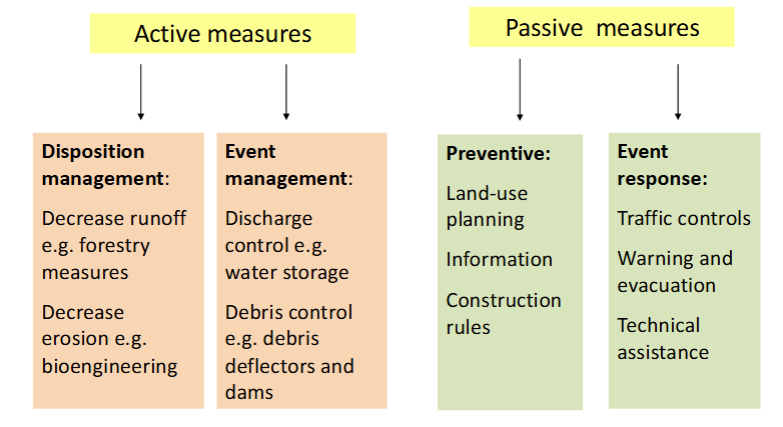
What are some active and passive measures used to mitigate debris flows?
How will the strength of frozen soils and rocks influence mountain infrastructure?
Frozen soils exhibit higher strength than unfrozen soils;
In general, frozen soil strength increases as temperature decreases and confining stress increases.
How will changing mountain climates influence borders?
In many regions alpine borders are defined by glacial watersheds or ridgelines;
As glaciers shrink their ridgelines can move, shifting the border with them.
What are three summary points from part C?
Mountains provide key resources often well beyond their boundaries and changing climate will impact on tourism, hydro-power, and natural hazards;
The mountain cryosphere, hydrosphere, and biosphere are very sensitive and vulnerable to climate change; and
Hazard mapping is a key tool in combatting destructive geomorphic events but cannot always be effective.