GEOL TEST 2
1/110
There's no tags or description
Looks like no tags are added yet.
Name | Mastery | Learn | Test | Matching | Spaced | Call with Kai |
|---|
No analytics yet
Send a link to your students to track their progress
111 Terms
Coast
Area of contact between land and sea - Extend inland until meets a different geographic setting
Shoreline
Precise boundary where water meets adjacent dry land
East Coast
Passive Margin Coastlines (submergent)
Barrier Islands and like sand idk
West Coast
Active Margin Coastlines
Sea cliffs and Rocky coastlines
Two major processes (forces) shape coastline
Waves, Tides
Waves
Waves do erosion (move sediment)
Tides
Twice daily rise and fall of sea level
Changes where waves act
how Wave formation
Wind blowing over water
Size of waves depend on
Wind speed, duration, and distance
Wind speed
faster=bigger waves
Wind duration
longer=bigger waves
Distance wind blows (fetch)
further=bigger waves
Wave Characteristics
Length (L), Height (H), Period (T)
Length
Distance between crests or between troughs
Height
Vertical distance between crest and trough
Period
Time for successive waves to pass a fixed point
Waves of Oscillation
(unmoving; further from shore)
Waves of Translation
(moving; closer to shore)
Wave refraction
waves bend as they approach the shore
Longshore currents
Currents parallel to the beach within the surf zone
They are the most important to modifying coastlines
Longshore (littoral) drift
Sediment carried by swash and backwash along the beach
Tides
Another force that occurs along every shoreline
They are the twice daily rise and fall of the sea, caused by the gravitational attraction of the Moon, and to a lesser degree, the sun
High Water
a water level maximum (high tide)
Low Water
a water level minimum (low tide)
Tidal Range
the difference between high and low tide
Spring Tide
full moon and new moon (14.77 days)
Neap Tide
1st quarter and 3rd quarter (14.77 days)
While waves erosion, its the tides:
change level of beach that waves act on and erosion takes place when waves interact with the bottom
Factors that impact coastlines
Tectonic setting
Materials present at the shore
Energy of water striking the coast
Rifted (passive) continental margins
tend to be dominated by depositional features
Active continental margin
tend to be dominated by erosional features
Erosional and depositional landforms
result of the action of ocean waves
Erosional coasts have
Sea cliffs
Sea stacks
Sea arches
sea caves
Depositional coasts have
Beaches
Spit
Barrier Island
Wave energy is focused on____
headlands
Headlands
prominent cliffs that jut out into deep water
attack the sides of headlands and form sea caves, sea arches, and sea stacks.
Depositional Coasts
Occurs when amount of sediment exceeds wave/current ability to transport it
Beaches
Relatively narrow strips of sand, pebbles, or cobbles deposited along a shoreline
90% of beach sediment comes from _____ that drain to coast distributed by _____
Streams, Long shore currents
wave action ____, _____, and ____ sediment
erodes, deposits, and moves
The beach is ____ every day
different
Barrier Islands
Long, low, narrow islands parallel to the coastline made of sand that flank main shoreline and separate bays from open ocean. Created by long shore currents
Why are barrier islands unstable
Easily washed over due to low relief
Sand migrates constantly with the wind
Constantly retreating landward with time
Spit
Narrow strip of sand that grows across the mouth of bay due to long shore current (hooks are hook shaped)
Similar to barrier island but it’s connected to mainland
Settlement in the Dynamic Environment
Wave - Continues eroding and modifying
Stability requires protections from waves
Structural approaches to “Controlling” Coastal erosion
Seawalls
Groins
Jetties
non-Structural approaches to “Controlling” Coastal erosion
Beach nourishment
Land use planning
Human Interference Dam
Impacts
Coastal zone short of fresh water
Cutoff sand supply
erosion > deposition
Reduces protection
Groins
walls built along beach extending into water
block sand movement along beach
cause sand to accumulate on up-drift side of groin
Breakwater
A hard, rocky structure built parallel to shore and attached to the sea floor
A few feet above sea level
Designed to break waves and make quiet water behind for safe harbor
intercept waves and protect boat moorings
provide safe harbors
radically change shoreline creating sediment deposits
Jetties
Designed to stabilize channel
Protect channel from large waves and sand deposition
Constructed in pairs at mouth of a river or inlet
Beach Re-nourishment
Adding sand to beach
mimics nature but has to be redone
Aesthetically preferable
Controversial
expensive and temporary fix
Hazards in Coastal areas
Sea level rise
hurricanes
Tsunamis
Sea Level Rise
Sea level was 120 meters lower during the last ice age
About 18,000 years ago, sea level began to rise as the glacial ice melted
In NYC
Sea level has risen 40 cm since 1850
Global warming is predicted to increase the rate of sea level rise
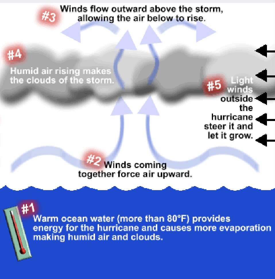
Hurricanes
Tropical cyclones (hurricanes, typhoons, etc.)
Intense storms that form in tropical waters when ocean is warmest
They uplift water collum
What does a hurricane need?
High winds
Winds up to 200 mph damage buildings
Heavy rainfall
causes floods in area where storm passes over; also downstream
Most damaging if it coincides with high tide
Worlds water resources
Oceans 97%
Glaciers, Snow, and permafrost 2.05%
Ground water .593%
Lakes, swamps, and rivers 0.0147%
Only 2.7% of globsl water is frshwater. most is locked in ice caps and less than .7% is available for human use
Where is groundwater
fractures
space between pores
cavities
in the zone of saturation (saturated) below the zone of aeration (unsaturated or partially saturated), split by the water table
What controls groundwater availability
Precipitation/snow melt - resupply
Porosity
Permeability
Porosity in Sediments
30% porosity in well sorted sediment
15% in poorly sorted sediment
low porosity in well-sorted, cemented sediment
Permeability
The ease of flow
Aquifer
Storage Bodies, Highly permeable
Aquiclude
Impermeable aquifers
Groundwater flow
gravity moves groundwater
AND hydraulic head - pressure
Typical rates of groundwater flow are as follows:
Ocean currents - 3 km /hour, Steep river channel - 30 km /hour
Groundwater - 0.00002 km /hour ~ 200 meters/year
Consequences of Groundwater withdrawal
Water table lowering – pumping
• Subsidence - over pumping
• Saltwater intrusion
• Reduced stream flows and may cause shrinking of lakes
• Contamination – domestic/commercial
• Depletion – aquifer can be non renewable
Artesian wells
formed when a well is drilled into a confined aquifer and the neatural pressure causes water to rise toward the ground surface
Water table lowering/pumping
reduced stream flows and may cause shrinking of lakes
subsidence
- overpumping
depletion
saltwater contamination
contamination - domestic/commercial
pumping wells
forms cones of depression
reverse flow
accelerate flow
cause water table drawdown
may dry up springs and wells
reverse flow pf rivers/ contaminate quifer
dry up rivers and wetlands
Ogallala Aquifer
Recharged during retreat of continental ice shet — mostly “fossil water” last ice age more than 11000 years ago
Water reserve was 2B acre feet
Moving water
california
more rain in northeast than south
Canal system (california aqueduct) built to move
Surface Water
Rain & snowmelt that runs off land surface and collects in lakes and rivers
most easily accessible fresh water
Stream
any body of water that flows in a channel
rivers
large streams
two types of streams
Ephemeral (Intermittent) and permanent
Drainage Basins
Region from which a particular stream gets all it’s water
Individual drainage basins separated by high topography (drainage divides)
Rivers carry sediment in a number of forms
suspended load
dissolved load
bed load
Competence
size of largest particles carried
Faster (high velocity) water carries larger particles
Carrying Capacity
quantity of sediment carried by a river
Depends on velocity of river and amount of water flowing (Discharge)
Discharge
Volume of water moving past a point over a unit time Q=WxDxV
W=average width of river
D=Average depth of river
V=velocity of the water
unit is feet idk kms
Braided streams
Steeper profiles (generally) and can carry coarse sediment (gravel, boulders)
Found in mountain and glacial regions where there is a lot of snowmelt in spring
Bars
ridge of sediments (middle or along side)
Meandering stream
usually found in lowland areas; slow, with with looping channels
carry sand, silt, and mud
Meandering streams are not stable but move back and forth across floodplain
constantly eroding and depositing sediment
cut bank
outside of loop where erosion takes place
point bar
inside of loop where deposition takes place
Deltas
when a river enters a large body of water, the current slows down
Sediments carried by the current drop out of the water
Main channel of river often breaks up into small channels (distributaries)
Floodplains
Areas of flat ground bounding a river channel on either side
usually narrow in mountains/hills but wide in low-land areas
What is a flood?
Water coming down a river is more than can fit in the channel
Water is forced over the bank and flows over the floodplain (overbank flow)
All rivers ____
flood! Some flood at very predictable times (like spring)
Types of floods
Flash floods
regional floods
ice-jam floods
Dam failure
flood stage
maximum amt of water that can be held in river
Recurrence Interval
Average time between events of a given size
Recurrence interval depends on
Depends on
Climate of region
Width of floodplain
Size of channel
Recurrence interval (T) = (N+1)/m
Upstream flood
intense rain
small area
floods done after rain
short lived
Downstream flood
Large area
lat time - delay (floods awhile after rain
large volume
sum of many smaller rivers and streams
long- lived
because water flows faster during floods _______
more sediment erosion occurs
Much sediment is redeposited when ______
the flood is over
One benefit of flooding sediment redepositing is ____
refertilization of soil on floodplain
Human impacts upon rivers
civilization
farming/drainage modifications
artificial food control