Final Exam Geology 1101 OSU Online
1/112
There's no tags or description
Looks like no tags are added yet.
Name | Mastery | Learn | Test | Matching | Spaced | Call with Kai |
|---|
No analytics yet
Send a link to your students to track their progress
113 Terms
Acadia National Park (figure above) is located within which of the following collisional mountain ranges?
The Northern Appalachians
Big Bend National Park (figure above) is located within which of the following collisional mountain ranges?
Marathon Mountains
Which of the following National Parks is found within the Zig-Zag Mountains (figure above), a name that comes from the sharply angular folds of the rock when seen from above?
Hot Springs National Park
Gates of the Arctic National Park (figure above) is located within which of the following collisional mountain ranges?
The Brooks Range
Onion Portage, a significant archaeological site and National Historic Landmark with evidence of human occupation dating back over 8,000 years, is a feature attraction of which of the following National Parks?
Kobuk Valley National Park
Kobuk Valley National Park (figure above) is located within which of the following collisional mountain ranges?
The Brooks Range
The continental collision between North America (Laurentia) and the microcontinent Avalonia (figure above) during the Appalachian-Caledonian Orogeny closed which of the following ancient oceans?
The Iapetus Ocean
The Grenville Belt is a region of ancient metamorphosed rocks that were formed during a continental collision event between 1.2 and 1.0 billion years ago (figure above). Grenville rocks are exposed in which of the following National Parks?
Shenandoah National Park
Shenandoah National Park (figure above) is located within which of the following collisional mountain ranges?
The Southern Appalachian Mts
The Chisos Mountains (figure above), a volcanic range formed by eruptions between 38 and 32 million years ago, is found in which of the following National Parks?
Big Bend National Park
The Mariscal Canyon (figure above), a remote, narrow, and deep canyon known for its towering walls, is found in which of the following National Parks?
Big Bend National Park
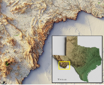
The figure above shows the jumbled topography of the Marathon Uplift, a Paleogene-age domal uplift in southwest Texas. Which of the following National Parks are found within the Marathon Uplift?
Big Bend National Park
The North Slope (figure above), is a treeless, tundra-covered area underlain by permafrost located in the northernmost region of Alaska. This extensive sedimentary basin is known ...
... for its vast oil and gas reserves
What type of volcano is Haleakalā, the largest volcano on the Hawaiian island of Maui?
Shield Volcano
Which of the following Hawaiian volcanoes has the oldest eruptive history, having last erupted over 60,000 years ago?
Kohala volcano
A flood basalt is a huge sheet of basaltic lava that erupt when a large mantle plume starts to rise beneath a crustal plate. Flood basalts are associated with which of the following geomorphic features?
Continental Hot Spots
The Continental Drift Theory was dismissed by the scientific community because ...
... the explanation for the force(s) behind the drifting of such large masses of land was not scientifically valid.
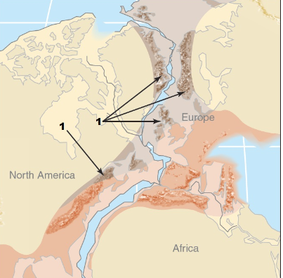
The figure below describes one of the pieces of evidence used by Alfred Wegener to suggest that the southern continents (South America, Africa, India, Australia, Antarctica) were all joined together before taking their current positions. Which of the following options correctly represent this evidence?
Mountain belts of similar ages in different continents match up if the continents are fit together.
The addition of the subduction zone concept to the sea-floor spreading model provided reasonable explanations for which of the following questions? (mark all that applies)
Why are oceanic rocks much younger than continental rocks?
Why is there so little sediment accumulation on the ocean floor, compared to the continents?
Why Earth does not get bigger as the seafloor spreads?
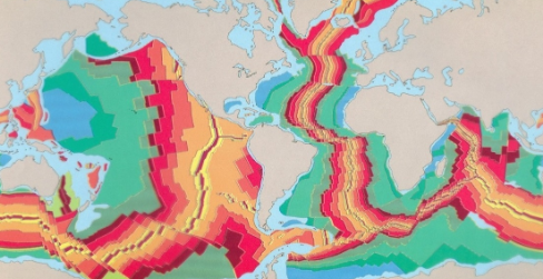
Which among the colors below represents the OLDEST seafloor rocks, based on the figure above?
Blue
One important piece of evidence supporting Wegener's idea came from the discovery of the magnetic banding of rocks from the seafloor. Which of the following options is correct regarding the age and magnetic polarity of these rocks? (mark all that applies)
The age and magnetic polarity of rocks on both sides of the mid-ocean ridges are SYMMETRICAL, i.e., the banding on one side MATCHES the banding on the other side.
The sea-floor is composed of magnetized rocks with alternating bands of normal and reversed polarity.
The YOUNGEST band of rocks are found along the mid-ocean ridges while the OLDEST band of rocks are found far away from the ridge.
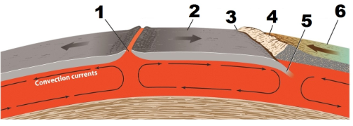
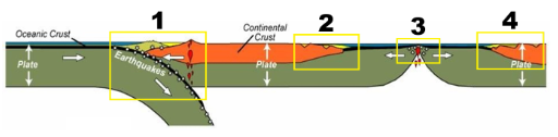
In the figure below, number 6 represents ...
continental crust
Which of the following options is true regarding the rocks in the ocean floor? (mark all that applies)
Seafloor rocks are MORE MAGNETIC than continental rocks.
Seafloor rocks are MORE DENSE than continental rocks.
Seafloor rocks are mostly VOLCANIC in origin.
There are three types of plate boundaries. The figure below represents which of the following plate boundaries?
A convergent plate boundary
A volcanic island arc occurs in which of the following types of plate boundaries?
An oceanic-oceanic convergent plate boundary
Mesa Verde National Park, in Colorado (figure above), is an example of parkland found on which of the following tectonic settings?
Divergent Boundary, Passive Continental Margin
Olympic National Park, in Washington (figure above), is an example of parkland found on which of the following tectonic settings?
Convergent Boundary, Accretionary Wedge
Continental rifts are places on land where continental crust is being "ripped" apart. Which of the following US National Parks are located within an ANCIENT continental rift zone (where crustal stretching has stopped and is not occurring today)?
Isle Royale National Park (MI)
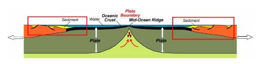
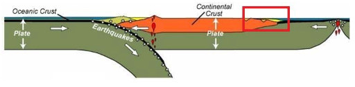
The area highlighted by the red box in the figure above is a representation of which of the following tectonic settings?
Divergent Boundary, Passive Continental Margin
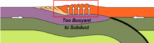
The area highlighted by the red box in the figure above is a representation of which of the following tectonic settings?
Convergent Boundary, Accretionary Wedge
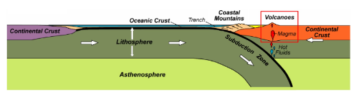
The area highlighted by the red box in the figure above is a representation of which of the following tectonic settings?
Convergent Boundary, Volcanic Arc
Virgin Islands National Park (figure above) is an example of parkland found on which of the following tectonic settings?
Transform Boundary, Strike-Slip Fault
There are 3 (three) subtypes of convergent plate boundaries. Which of the following US National Parks are located within a transform plate boundary?
Channel Islands NP (CA)
Which of the following types of rocks are commonly found on the thin veneer of the continental platform of the North American continent?
Sedimentary rocks
The portion of the North American continental landmass that consists of exposed, very old igneous and metamorphic rocks (the crystalline basement) is known as ...
... the continental shield
Which of the following sentences best describe the event #3 in the sequence of events that formed the rock strata in the figure below?
Deposition of layer B
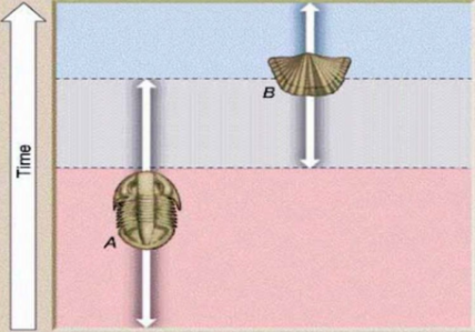
Throughout the 18th century, scientists learned to recognize distinct layers of sedimentary rock based on their fossil assemblage, i.e., the group of fossil species that each layer contained. Which of the following options are correct regarding the figure below? (mark all that applies)
The strata that contains ONLY fossil A is OLDER than the strata that contains BOTH fossils A and B
The strata that contains BOTH fossils A and B is OLDER than the strata containing ONLY fossil B
The strata that contains ONLY fossil A is OLDER than the strata that contains ONLY fossil B
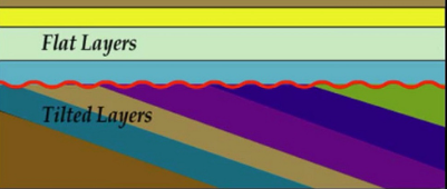
Unconformities are surfaces that represent periods of erosion or non-deposition, like missing pages of the geologic history book. Which of the following types of unconformity is illustrated in the figure below?
A nonconformity
Unconformities are surfaces that represent periods of erosion or non-deposition, like missing pages of the geologic history book. Which of the following types of unconformity is illustrated in the figure below?
An angular unconformity
Unconformities are surfaces that represent periods of erosion or non-deposition, like missing pages of the geologic history book. Which of the following types of unconformity is illustrated in the figure below?
An angular unconformity
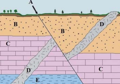
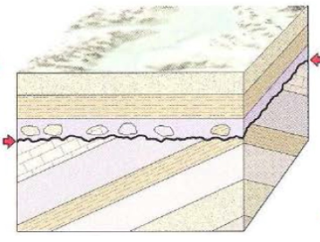
In the figure below, B, C and E are rock layers, D is an igneous intrusion (a dike), and A is a fault. Based on your understanding of the stratigraphic principles, which of the following options is correct?
The fault (A) is the youngest (last) event to occur, following the intrusion of the dike (D)
Potassium-40 (40K) - which is unstable - decays into argon-40 (40Ar) - a stable isotope. The half-life (or the time it takes for HALF the original amount of potassium-40 to decay) is 1.3 billion years, as indicated in the table above. If you measure the ratio of 40K to 40Ar in a rock sample and find 15 argon-40 isotopes for every one potassium-40, how old is that rock?
About 5.2 billion years old
Which of the following Eons constitute the Precambrian time, which covers the first 4 billion years of the history of our planet? (mark all that applies)
Proterozoic
Hadean
Archean
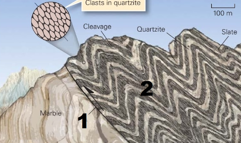
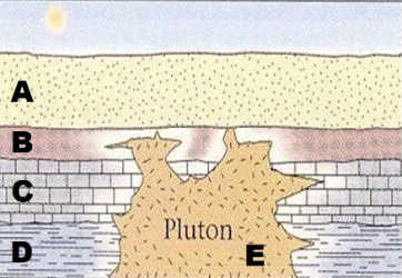
What is the name of the geologic structure indicated by number 2 in the figure below?
They are called folds
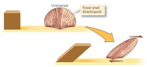
Geologists commonly refer to distortion as strain. We distinguish among different kinds of strain according to the nature of the change which developed during deformation. Which type of strain is indicated in the figure below?
Shear Strain
The action or process of changing shape/location/orientation of rocks or rock layers through the application of strain and stress is called deformation. Which of the following is correct regarding the effects of temperature on the type of deformation? (mark all that applies)
Colder rocks tend to deform britterly
Warmer rocks tend to deform plastically
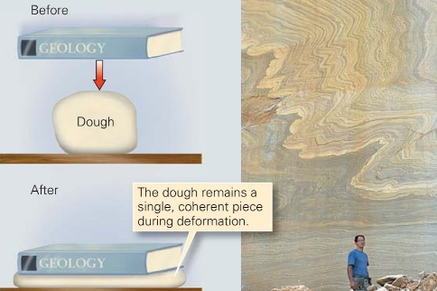
The action or process of changing shape/location/orientation of rocks or rock layers through the application of strain and stress is called deformation. Which of the following types of deformation is illustrated in the figure below? (mark all that applies)
Plastric Deformation
Ductile Deformation
During mountain building, the deformation resulting at any specific location actually depends on the stress developed at that location. Which of the following kinds of stress is illustrated in the figure below?
Tension
During mountain building, the deformation resulting at any specific location actually depends on the stress developed at that location. Which of the following kinds of stress takes place when one part of a rock body moves sideways past another?
Shear Stress
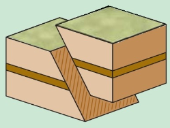
Faults are planar deformation features of natural origin on which sliding occurs. Which of the following types of faults is indicated in the figure below?
Oblique Fault
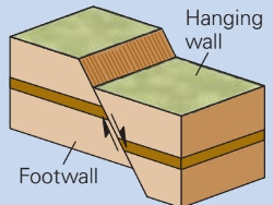
Faults are planar deformation features of natural origin on which sliding occurs. Which of the following types of faults is indicated in the figure below?
A normal fault

Folds occurs when one or a stack of originally flat and planar surfaces are bent or curved as a result of permanent deformation. The fold indicated in the figure below is called ...
Syncline
Folds occurs when one or a stack of originally flat and planar surfaces are bent or curved as a result of permanent deformation. The fold indicated in the figure below is called ...
Anticline

Which of the geologic structures below is indicated by number 1 in the figure above? (mark all that applies)
A fault-block mountain range
A “hoarst”
Which of the geologic structures below is indicated by number 3 in the figure above?
A normal fault
Snake Range (figure above), a long and narrow fault-block mountain in eastern Nevada, is located in which of the following National Parks?
Great Basin National Park
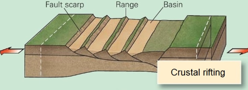
The stages of continental rifting affects the overall elevation of the terrain in parks along the Basin and Range Province. Which of the following National Parks represents the MOST ADVANCED stage of rifting?
Death Valley National Park
The Rincon and Tucson Ranges (figure above) are examples of ...
Fault block mountains
Portions of which of the following deserts are protected in Saguaro National Park (figure above)?
The Sonoran Desert
Portions of the Capitan Reef, a geologic formation found in western Texas and southeastern New Mexico (figure above), are preserved in which of the following National Parks? (mark all that applies)
Carlsbad Caverns National Park
Guadalupe Mountains National Park
There are more than 119 known caves within Carlsbad Caverns NP, some of the biggest and longest caves in the world. These caves are very unusual because ...
... they formed as result of sulfuric acid dissolution
The black rocks seen throughout Isle Royale National Park (figure above) are examples of ...
... an igneous rock called basalt
The long and narrow ridges (figure above) that run along the length of Isle Royale (45 miles) were formed by which of the following geologic processes?
Glacial Erosion
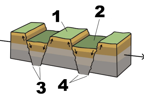
Which of the following options are correct regarding the tectonic activity at location #1 in the figure above during the later stages of rifting? (mark all that applies)
The newly-formed continental margin is passive
Faulting, earthquakes, and volcanic activity are all low
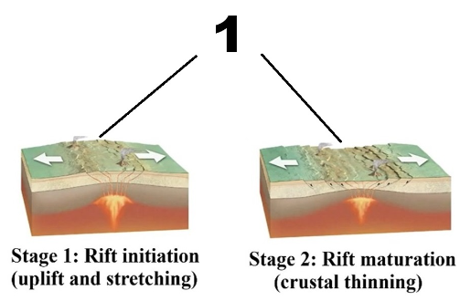
Which of the following options are correct regarding the tectonic activity during the initial stages of rifting (figure above)? (mark all that applies)
The fledgling plate margin (number 1 in the figure) is active
Faulting, earthquakes, and volcanic activity are all high
Which of the following options are correct regarding location number 1 in the figure above? (mark all that applies)
This is an active continental margin
This is an active plate boundary
During the Paleozoic, the eastern and western margins of Laurentia were covered by a shallow sea (figure above), where a variety of sediments, including sand-size, silt-size, and clay-size grains, as well as calcite shells of marine organisms, were deposited. Over time, these sediments transformed into sedimentary rocks such as sandstone, siltstone, shale, and limestone. These Cambrian-age sedimentary rocks are found today in which of the following states? (mark all that applies)
Kentucky
Arizona
Ohio
The area highlighted by the red box in the figure above is a representation of which of the following tectonic settings?
Divergent Boundary, Passive Continental Margin
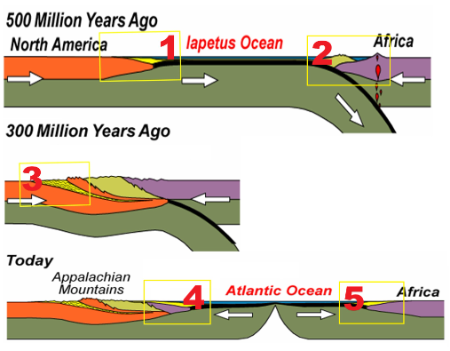
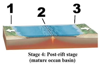
Which of the following options are correct regarding the figure above, which depicts the evolution of the eastern margin of the North American continent? (mark all that applies)
Everything but box 2 is a passive margin
The Boca Chita Lighthouse (figure above), is a popular attraction of which of the following National Parks?
Biscayne National Park
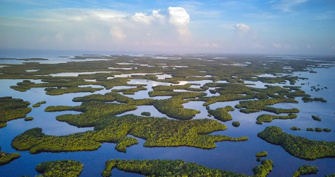
The Ten Thousand Islands (figure above), a chain of islands and mangrove islets, some of which were produced by mangroves growing on oyster bars, are a key feature of which of the following National Parks?
Everglades National Park
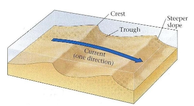
The figure above is a representation of which of the following sedimentary structures?
Asymmetrical Ripple Marks
The Sinkhole Plain of the Pennyroyal Plateau (figure above) is a typical example of karst topography that is found in which of the following National Parks?
Mammoth Cave National Park
Joints are natural cracks of different shapes and sizes that develop in all types of rocks. Which of the following options are correct regarding EXFOLIATION joints?
Exfoliation joints develop PARALLEL to the ground surface and are typical of IGNEOUS rocks
A mountain stream during the spring, rumbling downhill through a steep valley, wearing and breaking the rocks on its path, is a typical example of ... (mark all that applies)
physical weathering
mechanical weathering
The action of burrowing creatures (such as earthworms, gophers, and moles), using their teeth and claws to dig holes, slowly extracting fine particles from the rock, can be considered an example of ... (mark all that applies)
physical weathering
mechanical weathering
biological weathering
The soil in one locality can differ greatly from the soil in another, in terms of composition, thickness, and texture. One of the major factors in this soil diversity is the local climate. Which of the following options is correct regarding the relationship between soil characteristics and climate? (mark all that applies)
The layer of humus and topsoil is MOST developed in MOIST (temperate) climates
The layer of humus and topsoil is LEAST developed in WET (tropical) climates
The soil in one locality can differ greatly from the soil in another, in terms of composition, thickness, and texture. Besides local climate, other factors that influence soil formation include the composition of the substrate, the steepness and wetness of the terrain, the age of the soil, and the vegetation type. Which of the following options is correct regarding these factors? (mark all that applies)
Soils formed on different substrates will have different chemical composition
Different kinds of plants extract or add different nutrients and quantities of organic matter to a soil
Thick soils accumulate easier under flat terrain than on steep slopes
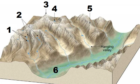
Glaciers not only transport material as they move, but they also sculpt and carve away the land beneath them. Which of the following glacial landforms is indicated by number 2 in the figure below?
Cirque
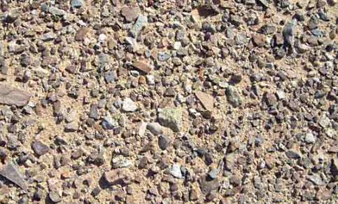
The figure below is a desert pavement from the Mojave Desert, in southeastern California. This accumulation of coarse sediment was left behind when wind erosion blew away fine-grained sediment. This type of deposit, typical of desert environments, is called ..
lag deposit
Most slopes are composed of several segments (called slope segments) that are either straight or curved. Which of the following options is correct regarding straight slope segments?
Straight segments are usually associated with HARD rocks, which are DIFFICULT to erode
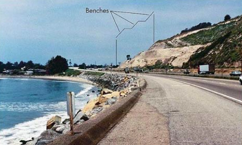
In areas where a hazard exists, people can take certain steps to minimize the risk of mass wasting and improve slope stability. The figure below shows the regrading (terracing) of a slope. The primary purpose of this regrading is to ...
... reduce slope steepness
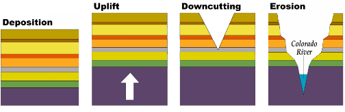
The figure above reflects the sequence of geologic processes leading to the formation of the features observed today in many of the national parks of the Colorado Plateau, in the US southwest. The deposition of the sedimentary rock layers was followed by an uplift of the plateau which started at the end of which of the following geologic time periods?
The Mesozoic Era (from 250 to 65 Ma ago)
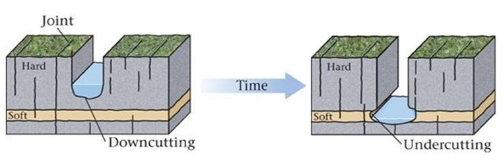
The shape of a canyon or valley depends on the resistance of its walls to erosion slumping. If the stream is downcutting through HARD layers of rock (figure above), which of the following geomorphic features will result?
A slot canyon
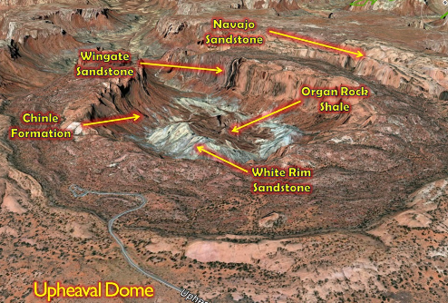
The figure above lists the sedimentary layers from Upheaval Dome, in Canyonlands NP. Which of the rock layers is the younger, i.e., it was the LAST to be deposited?
The Navajo Sandstone
The Chocolate Drops (figure above) is a geologic feature found in which of the following districts from Canyonlands NP?
The Maze District
Which of the following major rivers runs through the southeastern boundary of Arches National Park?
The Colorado River
The Paradox Formation (highlighted in the figure above) is the oldest sedimentary layer exposed in Arches NP. Which of the following options correctly describes this geologic formation?
Gypsum and salts deposited by precipitation of mineral crystals during evaporation
The figure above shows the geological evolution of features formed in which of the following national parks?
Bryce Canyon National Park
The Painted Wall of Black Canyon of the Gunnison NP (figure above) contain metamorphic and igneous rocks that formed over 1.4 billion years ago, during a geologic time period called ...
... the Proterozoic Eon
The figure above is a representation of the rock layers in Mesa Verde National Park. The youngest sedimentary layers (the sand-rich layers of the Cliff House Sandstone) were deposited 80 million years ago, during a geologic time period called ...
... the Cretaceous Period
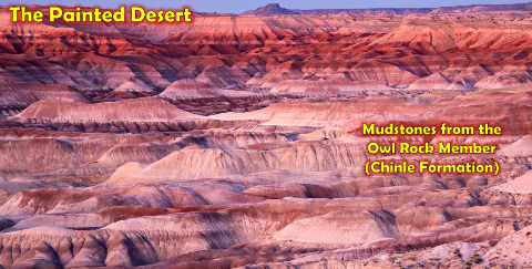
The dominant geomorphic feature in the Painted Desert (figure above), an arid terrain that has been extensively eroded by wind and water, are ...
… badlands
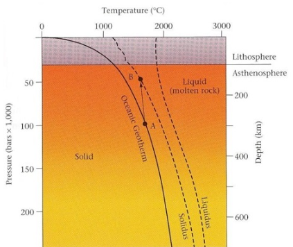
In the figure below, "the curve at which solid rock begins to melt" is called …
The Soldius Line
Which of the following options is true regarding the difference between magma and lava? (mark all that applies)
MAGMA that reaches the surface is called LAVA
Most MAGMA is generated in the upper mantle
Underneath every volcano lies a reservoir of molten rock called MAGMA
Under the temperature and pressure conditions that occur inside the lithosphere and the asthenosphere, only a small percentage of the rock at a given location can melt before the magma migrates to the surface. So, when the temperature rises only enough for some of the minerals in a rock to melt (but not all of them), we call this process …
... partial melting
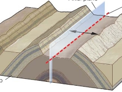
There are five (5) basic geologic settings in which volcanoes form, in the context of plate tectonics. The figure below shows a volcano formed in which of the following tectonic settings?
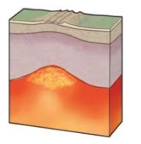
Continental rift
There are five (5) basic geologic settings in which volcanoes form, in the context of plate tectonics. The figure below shows a volcano formed in which of the following tectonic settings?
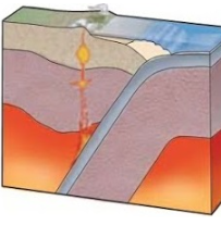
Continental volcanic arc
Explosive volcanoes produces large amounts of pyroclastic material that accumulates around the vent, building steep-sided volcanoes called ...
Composite volcanoes
Fluid lava flows (such as those of Hawaiian volcanoes), build up to form broad, flat volcanoes with very gently sloping sides called ...
… shield volcanos