River and Fluvial Processes, river landforms.
1/47
There's no tags or description
Looks like no tags are added yet.
Name | Mastery | Learn | Test | Matching | Spaced | Call with Kai |
|---|
No analytics yet
Send a link to your students to track their progress
48 Terms
What is erosion? What does it depend on?
Erosion is the wearing away of land.
The ability of the river to erode depends on its velocity (speed).
Vertical erosion (generally in upper course) happens because of gravity, and the river is trying to reach base (sea) level as quickly as possible.
Lateral erosion occurs in the middle and lower courses.
What is the load of a river?
The sediment in it.
What does the amount of sediment carried depend on?
The volume of water - the greater the volume, the more load it can carrry.
The velocity - a fast flowing river has more energy to transport and can move larger particles.
The local rock types - some rocks (eg shales) are more easily eroded than others (eg granite).
Therefore, the total amount of load in a river increases with distance downstream.
Describe deposition in a river.
Deposition is the process by which a river deposits its load.
Material deposited by a river is the sediment.
The bigger the particle, the more energy is required to keep it going.
When velocity falls, the largest particles will be deposited first. The finest particles will be deposited last.
The hilstrom curve: describe what this shows about discharge and velocity in a river.
Velocity increases as discharge rises, and this enables a river to pick up larger particles.
As velocity and discharge decrease, particles are generally deposited according to their size, largest first.
It takes less energy (velocity) to keep particles moving that it does to erode and pick them up.
What is solution (fluvial) also known as?
Corrosion.
River Processes: what is traction?
Large stones and boulders are rolles along the river bed by water moving downstream.
This process only happens at times of high discharge (and consequently high energy levels). This is usually therefore during times of flood.
River Processes: what is saltation?
Where small stones bounce along the river bed.
This process is associated with relatively high energy conditions (not necessarily floods but high flow conditions).
Small particles may be caught up in the flow momentarily, but dropped further downstream when energy levels drop. When they are deposited, they dislodge other particles that then get caught up in the flow of this river.
River Processes: what is suspension?
Where very small particles of and and silt are carried along by the flow of the river.
This material is picked u but also carried, mainly by turbulence.
Suspension usually contributes the largest proportion of load within a river.
Its also the cause of the brown/murky coloured rivers.
River Processes: what is solution?
Most active on rocks that contain carbonates, like limestone and chalks.
The minerals in the rock are dissolved by weak acids in the river water and carried away in the solution.
Unable to be seen with the naked eye.
Fluvial Processes: what is abrasion?
Where small boulders and stones scratch and scrape their way down a river during transport, and wear away the rivers and bed and banks.
Responsible for both vertical and lateral erosion.
Stones that have fallen into the river having been recently broken off will be sharp and angular.
These are particularly effective at abrasion.
The process is most effective in short turbulent periods when the river is at bankfull or in flood.
Fluvial Processes: what is hydraulic action?
When water hits the river bed and banks and forces both air and water into cracks. This compresses the air in the cracks. Repeated changes in air pressure weakens the channel, leading to erosion of the bed and banks.
Caused by the sheer power of fast-flowing water.
Responsible for vertical erosion in the upper course.
Responsible for lateral erosion in the lower course.
Fluvial Processes: what is Attrition?
The reduction of particle size within a river due to them colliding and knocking against other particles.
They hit into eachother as well as the bank and bed.
As they move downstream, they become smoother, smaller, and more rounded, consequently larger, more angular particles/rocks tend to be found upstream.
Describe interlocking spurs.
Erosion.
Projections of high land that alternate from wither side of a velly and project into the valley floor.
Found in the upper course, where rocks are hard, eg. Afon Duas Valley, a tributary of the river Severn.
Characteristics:
Steep gradient
Convex slopes\project from alternate sides of the valley
Separated by narrow valley floor, mostly taken up by the river channel
Sometimes wooded.
Describe stage 1 of the formation of interlocking spurs.
Stage 1:
In the upper course, the river’s water volume and discharge are low.
The river uses most of its energy overcoming friction with the channel.
What energy is has left over is used by hydraulic action to deepen the channel.(Vertical erosion).

Describe stage 3 of the formation of interlocking spurs.
Stage 3:
The winding path taken by the river is due to obstacles of harder rock in its path.
The river takes the easiest route over the land.
This results in projections of high land entering the valley from alternate sides.
These projections are interlocking spurs.
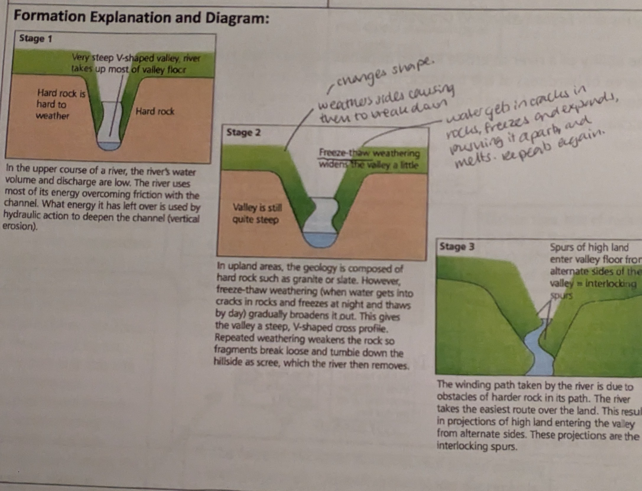
Describe stage 2 of the formation of interlocking spurs.
Stage 2:
In upland areas, geology is composed of granite or slate. Freeze-thawing can occur (when water gets into cracks in rocks, and freezes at night and that's by day), which gradually broadens it out.
This gives the valley a v-shaped cross profile. Repeated weathering weakens the rock so fragments break loose and tumble down the hillside as scree, which the river then removes.

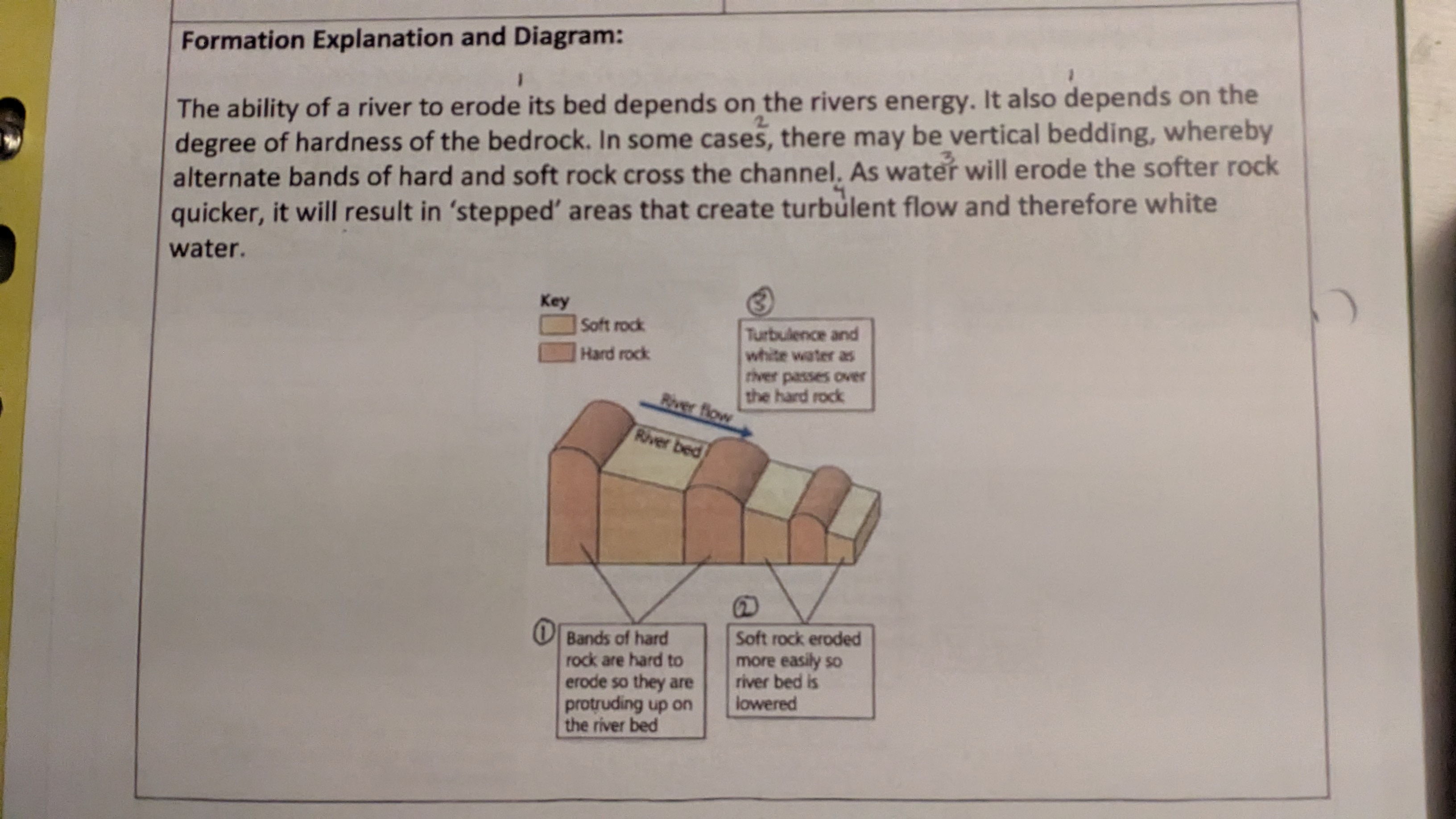
Describe Rapids.
Erosion.
Are fast flowing, turbulent sections of a river where the river bed has a relatively steep gradient.
In the upper course, eg the river Severn just south of irnbridge gorge, shropshire.
Describe stage 1 and 2 of the formation of rapids.
The ability of a river to erode its bed depends on the rivers energy. It also depends on the degree of hardness of the bedrock. Bnds of hard rock are hard to erode, so they are protrudung up on the river bed.
In some cases, there may be vertical bedding, whereby alternate bands of hard and soft rock cross the channel. Soft rock is eroded more easily, so the river bed is lowered.
As water will erode the softer rock quicker, it will result in ‘stepped’ areas that create turbulent flow, and therefore white water.
Describe waterfalls.
Example of erosion.
Is where water falls down a veritcal channel, usually from a considerable height.
Usually found in the upper course, eg ‘Break-its-neck’ waterfall on a tributary of the River severn.
Has hard rock with soft rock underneath
Pverhang leaving a ‘cap’ of rock
Bare rock
White water at the base into a ‘plunge pool’
Erosion at the base through hydraulic action and abrasion.
Describe the formation of a waterfall: steps 1-3.
The softer, less resistant rock is eroded quicker than the harder, more resistant ‘cap’ of rock above.
It’s eroded through hydraulic action - the force of the water hitting the softer rock as it as it falls into the wall (splashback), and through rock particles hitting the base of the rock and wearing it away through abrasion.
The erosion of the softer rock causes the undercutting of harder rock.
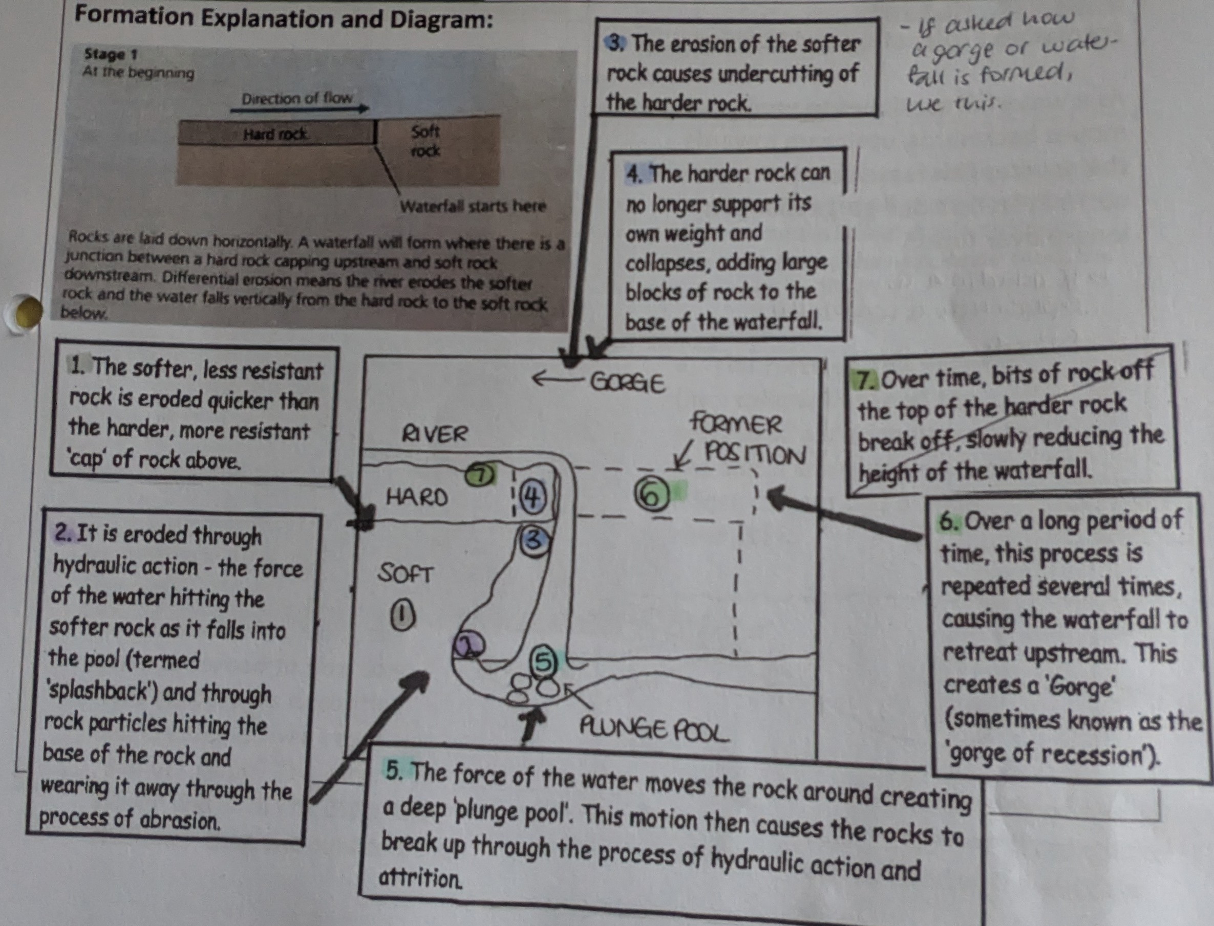

Describe the formation of a waterfall: steps 4-6.
The harder rock can no longer support its own weight and collapses, adding large blocks of rock to the base of the waterfall
The force of water moves the rock around, creating a deep ‘plunge pool.’ this motion then causes the rocks to break up through the process of hydraulic action and attrition.
Over a long period of time, this process is repeated several times, causing the waterfall to retreat upstream. This creates a ‘gorge.’
Describe a gorge.
Erosion.
Is a narrow, steep-sided valley with bare, rocky walls.
Found in the upper course, immediately downstream of a waterfall, eg a small one after the ‘break’its’neck’ waterfall on a tributary of the River Severn.
Has a very narrow valley
Very steep, high, valley sides
River channel takes up most, if not all, of the valley floor
Turbulant, fast flowing white water
Bare rock on valley sides
Boulders on the river bed
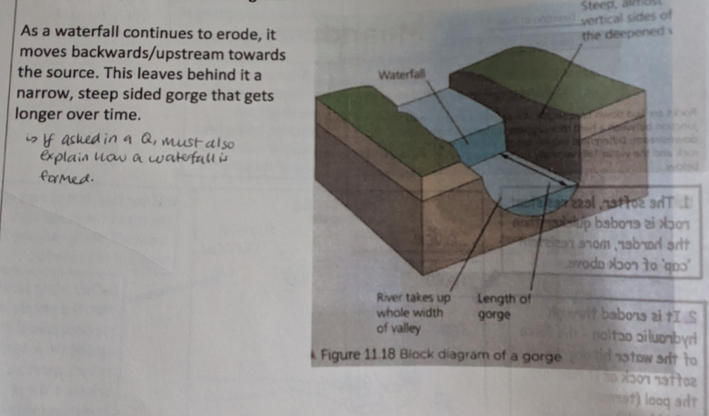
Describe the formation of a gorge.
As a waterfall continues to erode, it moves backwards/upstream towards the source. This leaves behind it a narrow, steep sided gorge that gets longer over time.
(If asked in exam, also explain the process of a waterfall).
Describe a meander.
Is a bend in the river
Is erosion and deposition.
Found in the middle and lower courses, eg the river Severn - including shrewsbury on the inside of a bend ant at arlingham.
Describe the features of the inside bank of the meander.
Curved, beach-like feature
Very gentle, convex slope (called a slip-off slope, with a point bar as it enters river.)
Sediment consists of sand, gravel and pebbles that are smoothed and rounded by attrition.
Vegetation begins to grow furthest from the water
Flow is slow and water shallow.
Describe the features of the outside bank of the meander.
A steep drop down into into the river (usually termed a ‘river Cliff')
Can be several metres high
Composed mostly of bare earth
Loose material at base
Flow is fast and water is deeper
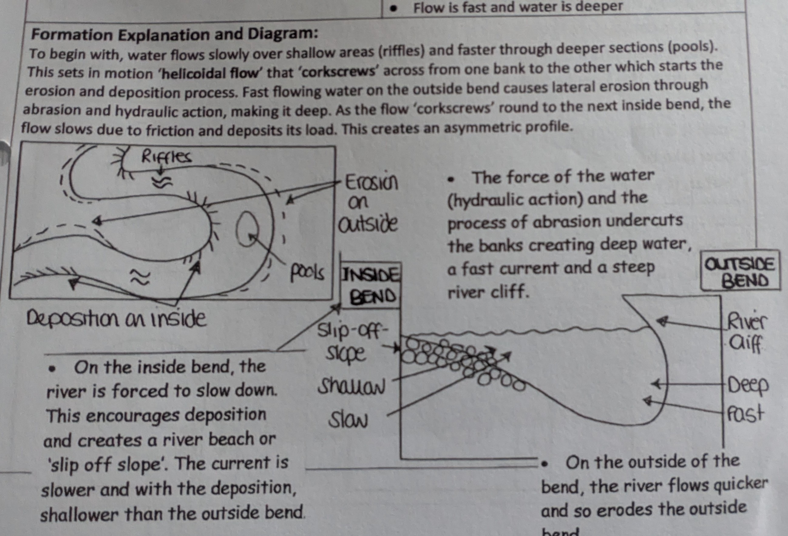
Describe the formation of a meander: stage 1-3
Water flows slowly over shallow areas (riffles) and faster through deeper sections (pools).
This sets in motion ‘helicoidal’ flow that ‘corkscrews’ across from one bank to the other, which starts the erosion and deposition process.
Fast flowing water on the outside bend causes lateral erosion through abrasion and hydraulic action, making it deep.

Describe the formation of a meander: stages 4-5
As the flow ‘corkscrews’ round to the next inside bend, the flow slows due to friction and deposits its load. This creates an asymmetric profile.
The force of the water (hydraulic action) and the process of abrasion undercuts the banks, creating deep water, a fast current, and a steep river cliff.
What is an ox-bow lake?
Erosion and deposition.
Is a small, horseshoe-shaped lake that is located several metres from a fairly straight section of river.
Found in middle and lower courses, eg welshpool on the river Severn.
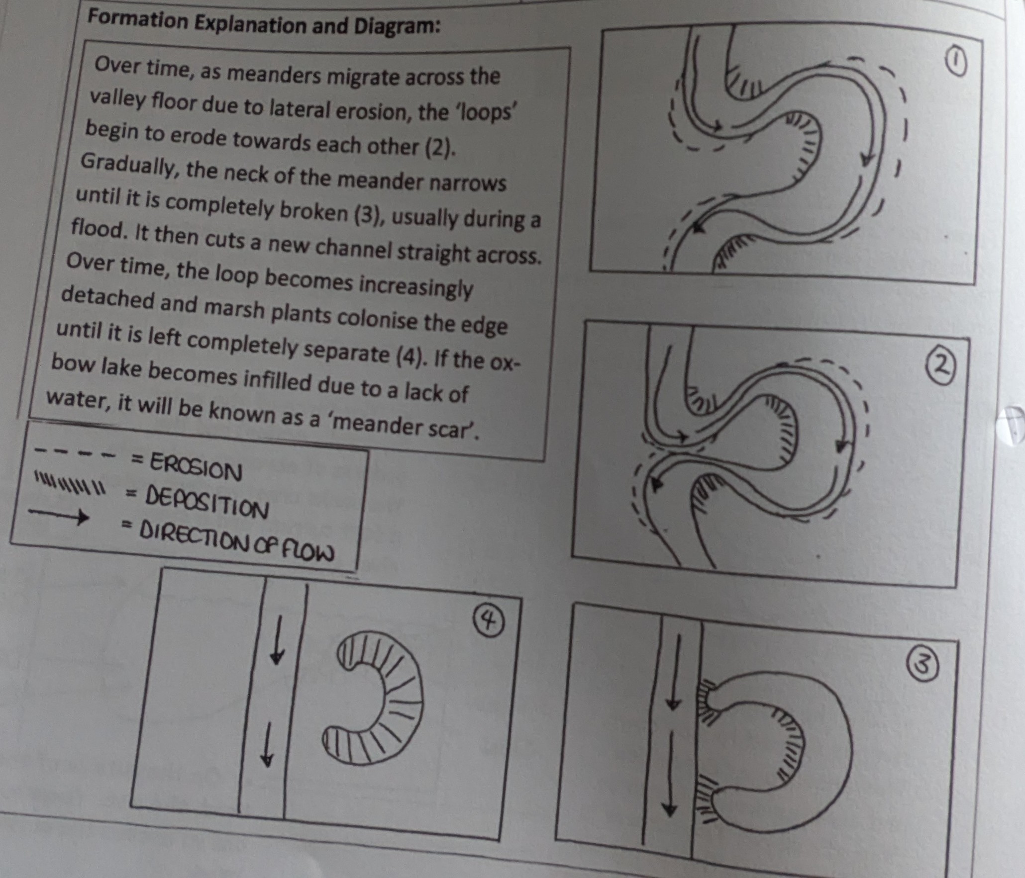
Describe the formation of the ox-bow lake.
Over time, as meanders migrate across the valley floor due to lateral erosion, the ‘loops’ begin to erode towards each other (s2 in diagram)
Gradually, the neck of the meander narrows until it’s completely broken (3), usually during a flood.
It then cuts a new channel straight across.
Over time, the loop become increasingly detached, and marsh plants colonise the edge until it’s left completely separate.
If the ox-bow lake becomes infilled due to a lack of water, its known as a ‘meaner scar.’
What is a levee?
Deposition.
A naturally raised river bank found on one or both sides of a river channel, that's prone to flooding.
Found in middle and lower courses, eg minsterworth near gloucester on the river Severn.
Describe the characteristics of a levee.
Raised river banks (about 2-8 metres in the UK)
Composed of gravel, stones and alluvium
Grading of sediments, with biggest close to the river bank, and smaller further away.
Steep sided, steeper on the channel side than on the land side.
Fairly flat top, naturally covered by grass, often used as a footpath, eg Severn way.
Describe the formation of a levee.
(before levee) Silt deposits on flood plain
(During a flood) Heaviest, most coarse sediment deposited closest to river as more difficult to transport. Finest particles of sediment carried further on the flood plain. River bed deposits.
(After many floods) With every flood, the river banks are built a little higher. The raised banks either side of the river are natural levees. River bed builds up bed load deposits over time. This raises the level of the river, so increases probability of flooding.
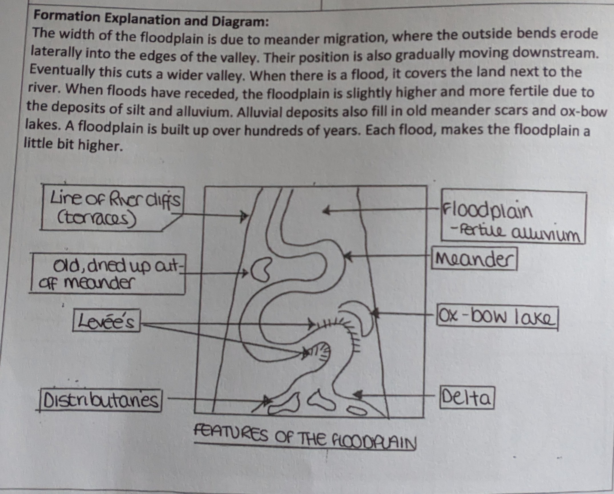
What is a floodplain? (And characteristics)
Deposition.
A large area of flat land either side of a river that's prone to flooding.
Found in middle and lower courses, eg tewkesbury, gloucestershire and gloucester on the river Severn.
River bluff (areas of slightly higher land t the edge of floodplains)
Layers of alluvium covering the floodplain
On an OS map, wide white areas next to a river.
Describe the formation of a floodplain: steps 1-3
The width of the floodplain is due to meander migration, where the outside bends erode laterally into the edges of the valley.
Their position is also gradually moving downstream. Eventually this cuts a wider valley.
When there's a flood, it covers the land next to the river.

Describe the formation of a floodplain: steps 4-6
When floods have receeded, the floodplain is slightly higher and more fertile due to the deposits of silt and alluvium.
Alluvial deposits also fill in old meander scars and ox-bow lakes.
A floodplain is built over hundreds of years. Each flood makes the floodplain a little bit higher.
The River Severn: Where does it start?
As a boggy pool 600m above sea level in the cambrian mountains in Wales.
2500mms of rainfall fall here per year.
The small stream of the ‘infact river' cuts downwards to create the river severn’s v-shaped valley.
The River Severn: Describe its waterfall.
The ‘break-It's-neck’ waterfall occurs in the upper course of Wales and is 75ft high.
It’s situated off the A44, approximately 1.5 miles west of New Radnor.
The river then drops into a short, steep sided gorge.
The River Severn: Describe its meanders.
One, of several, occurs at Abermule, Powys, in mid-wales. The slip-off-slope consists of coarse material.
The River Severn: Describe the ox-bow lakes.
One of several occurs at Upper Lode, near tewkesbury.
The River Severn: describe levees and floodplains.
One of several, is the artificial leveeat the base of the Breiddon Hills.
The offa’s Dyke Path uses this as a part of its route
There are many floodplains along the river Severn, some are built on but many are left as farm land.
The River Severn: What happens after gloucester?
The river Severn becomes and estuary.
At this point, its 2kms wide, and has one of the widest tidal ranges in the country. The difference between high and low tide can be 15m. By the time the estuary reaches western-super-mare, the river is 14kms wide.
The river Severn comes to its end (the mouth) and joins the bristol channel.
Summarise the River Severn.
In total, the river Severn is 350kms in length and has a drainage basin area of over 11,000 sq kms.
What is an estuary?
The tidal part of a river where freshwater from the river merges with saltwater from the sea.
What are characteristics of an estuary?
A high tidal range. (River severn’s over 15m).
Very wide
Tidal bores (huge waves that funnel up the river)
How is an estuary formed?
A large river, such as the Severn, entered the sea at a narrow mouth.
After the ice age, melting ice caused a rise in sea level. This caused low lying valley sides either side of the river to become flooded.
The original channel of the river is now on the estuary floor where it provides a deep channel for shipping.
Describe estuary mudflats.
Mudflats form in sheltered areas where tidal water flows slowly.
As a river transports alluvium down to the sea, an incoming tide transports sand and marine silt up the estuary.
Freshwater and salty sea water begin to mix.
Where waters meet, velocity is reduced which causes deposition.
This builds up layers of mud called mudflats.