Hydrological hazards (Floods)
 Call Kai
 Learn
Learn Practice Test
 Spaced Repetition
 Match
Match Flashcards
 Knowt Play
1/91

There's no tags or description
Looks like no tags are added yet.
Name | Mastery | Learn | Test | Matching | Spaced | Call with Kai |
|---|
No analytics yet
Send a link to your students to track their progress
92 Terms
When does water become a hazard
When water is present in places that is not normal on a usual basis
What creates the hazard of a flood
The need/expectation for an area with certain infrastructure and development to stay dry
what is the most common hazard type
floods
what percent of all hazard events are floods
43%
What percent of all hazard events are storms
28%
What percent of all hazard events are earthquakes
8%
What percent of all hazard events are extreme temperatures (heatwaves or cold)
6%
What percent of all hazard events are landslides
5%
What percent of all hazard events are drought
5%
What percent of all hazard events are fires
4%
What percent of all hazard events are volcanic activity
2%
Floods are characterized by…
High losses (1990-2010 there were 200,000 deaths caused by floods and 3 billion people affected)
What percent of flood related deaths occur in Asia
90%
What percent of flood-related losses occur in Asia
50%
Where have the five most disastrous floods all occurred
China
What is New Zealand’s #1 hazard in terms of frequency and cost
Floods
Why are many New Zealander’s at risk of floods
Most people live close to the coast or on active floodplains
Who is primarily affected by floods
people in lower socio-economic positions and in specific places, minorities
In 2023 extreme weather was responsible for…
3,875.5 million dollars in insured damages (most of the cost was incurred by two events, Auckland anniversary flooding and Cyclone Gabrille)
Variables of floods that influence threat level
Depth of water, velocity of water, duration of flooding, quality of water
Flood damage thresholds based on what
Velocity and Depth (largely about stress on structures)
Threats after flooding
Infrastructure damage, disease, crop damage and failure, sediment transportation, debris, erosion, deposition
Advantages of floods
Flood pulses and habitat maintenance in wetlands, flood sediments and soil fertility on floodplains, important role in agriculture in specific regions (flood-retreat agriculture)
Coping capacity of flooding
a level of flooding can be managed and taken advantage of, flood in excess of this level becomes a hazard (more water than normal, persistent levels of water
What does LDC stand for
Less developed country
What does MDC stand for
More developed country
How do floods impact MDCs and LDCs
Impact them differently, LDCs experience more loss of life, MDCs experience more threat to infrastructure and cost damages
What percent of declared disasters in the US are from river flooding
66%
What percent of the flood risk in the UK is from rivers
33%
What percent of towns in NZ have a river flooding problem
70%
Why is there a difference between river flood risks in the US and NZ compared to the UK when they are all MDCs
Differences in magnitude/frequency distributions, US and NZ have high magnitude rainfalls compared to UK which also has smaller and more passive rivers
What are some flood prone environments
Low-lying floodplains, low-lying coasts and deltas, areas subject to flash floods, areas below unsafe dams, low-lying inland shorelines, alluvial fans
What makes low-lying floodplains flood prone
Low lying land adjacent to rivers (MDC/LDC contrasts — flood protection, social mitigation)
What makes low-lying coasts and deltas flood prone
Combined effects of high tide and high flood flows, deltas often densely populated
What makes areas subject to flash floods so flood prone
Semi arid, unvegetated, high intensity consecutive rainfall
What makes areas below unsafe dams flood prone
overtopping and failure, engineered hazard, construction and maintenance standards
What makes low-lying inland shorelines so flood prone
Oscillations in lake levels storage elements in hydrological system, Wet/dry periods over the years
What makes alluvial fans so flood prone
Special case of flash floods, high stream instability, high stream power
Alluvial fan definition
An alluvial fan is a fan-shaped deposit of sediment that forms where a stream or river exits a narrow canyon and spreads out onto a flatter plain.
Characteristics of coastal flooding
Low barometric pressure during large storms allows sea level to rise, high wave heights + wave energy, winds pile seawater onto the coast,
What influences coastal flooding severity
timing of tides (high/low/spring) and arrival of the flood wave
Storm surge defitition
Abnormal rise in sea level generated by a storm, exceeding the predicted astronomical ride, which can cause severe coastal flooding
What maintains glacier lakes
Dammed by a combination of glacial ice and moraines. Lakes and damn may be ephemeral or ling-lived features
Moraine definition
A mass of rocks and sediment carried down and deposited y a glacier, typically as ridges as its edges or extremity
Characteristics of glacier dams
Can form or change function spontaneously through jamming of ice in outlets or rapid break up of the glacier terminus, Failure of glacier dams can happen without warning and release large volumes of water into downstream catchments and settlements. Limits ability to warn downstream communities
Glacier terminus definition
The lowest end of a glacier where ice meets land, water, or another ice mass, and it dynamically advances or retreats (also called toe or snout)
Characteristics of River floods
Caused by high rainfall (intensity/duration relationships) Are somewhat predictable (seasonal patterns like monsoon seasons), spatial variability is an issue when predicting, Connective (localized high intensity short duration)
Factors that create high rainfall
Frontal lifting, orographic, cyclonic (particularly tropical, hurricanes, typhoons, tropical cyclones)
Frontal lifting definition
Warm less-dense air is forced to rise over a colder air mass along a frontal boundary, leading to cloud formation and often precipitation
Orographic effect
Air is forced to rise over elevated terrain, cooling and condensing to produce clouds and precipitation on the windward side while creating dry conditions on the leeward side
Where is the term hurricane used
North Atlantic and eastern North Pacific regions
Where is the term typhoon used
Northwest Pacific Ocean
Where is the term tropical cyclone used
Indian ocean and South Pacific
Important characteristics of catchments (watersheds)
Catchment relief (steep or low relief), catchment geology and soil (infiltration capacity), prior conditions (soil saturation, slope cohesion, sediment availability, bank capacity)
Characteristics of catchment conditions for Cyclone Gabrielle
Wet summer + cyclone hale a few weeks prior, narrow short catchments, soft erosion prone bedrock, high intensity long duration rainfall, maturation and clearance of pine plantations in the years prior (large volumes of sediment and slash sitting on hillslopes
Role of catchment conditions in the Texas hill country floods
Steep drainage basin, thin rocky soil with limited infiltration capacity, prolonged drought conditions had hardened soils, reducing infiltration capacity further, remnants of a tropical storm stalled out over Texas, >300mm of rain in a few hours, Guadalupe River rose 8 m in 45 minutes
How does land use change influence river flooding
Pasture conversion & deforestation decreased soil stability and can compact soil making it less absorbent, Reforestation can reduce flood damage and risk
How can urbanization influence river flooding
drains can channel flood waters and reduce flood damage or can back up causing flooding, impervious surfaces create more runoff heightening flood severity
How does a forested or natural catchment influence storm runoff
More absorbent with natural vegetation, slows overland flow, gradual delivery of water to channel, lower flood peak, long descending climb
How does an urbanized catchment influence storm runoff
slick and impervious surfaces, network of storm piped can channel runoff but release it to channel more rapidly, “flash” floods
Why are certain groups more vulnerable to flooding
Is a product of historical planning practices and boarder socio-cultural conditions, these groups often have less resources to cope with and recover from these events
Explain the levee effect
Newly built flood defenses increase demand for building on low-lying areas, thought to be fully protected for future floods, land values rise, more structures are built, more assets at risk, claims for higher levels of protection, flood losses continue to rise
What is the most widely used approach in the management of any hazard (even earthquakes)
River engineering
What is the most favored form of flood control
Flood embankments
What do flood embankments do
Increase channel capacity
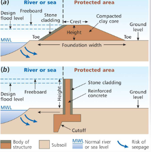
How are flood embankments constructed
Earth cored most common type, concrete walls, height is based on a specific type of flood (often 100 yr recurrence interval)
Other flood control measures
Flood control dams, flood abatement schemes,
What is a flood abatement scheme
Integrated management of soil, vegetation, and drainage
When was the resource management act established
1991
Functions of regional councils under the RMA
The avoidance or mitigation of natural hazards
Methods of flood proofing
Structures designed to survive flooding, raising, hardening, set back
What requirements do houses have in hurricane prone areas
Often have building codes that mandate minimum home elevations and/or flood spaces to be incorporated into home design
Characteristics hazard insurance
Often not compulsory, individualizes risk, does not encourage preparedness, incentive schemes (premiums reduced for measures taken), actuarial issues (statistics), repeated payouts (higher premiums), loss or lapse in coverage (disaster induced poverty)
Where do international sources of post-disaster aid come from
World bank, NGO’s like red cross, red cresent, save the children (important for LDCs)
Where do local sources of post-disaster aid come from
Central government, regional government, mayoral relief funds
How can we adjust to the hazard in order to minimize the risk
Preparation and planning (education, engineered structures etc.), forecasting (predicting events), land use planning (avoiding hazardous areas or only having low-risk ventures in these areas)
What are some institutions that aid in preparation, planning, and action during disasters
FEMA (Federal Management Authority in the US), Homeland security, Civil Defense (NZ), Armed forces
What are the roles of Civil Defense in New Zealand
Aid in education, declare states of emergency, are regionalized
What are the 4 Rs
Reduction (of risk), readiness, response, and recovery
When was the Civil Defence Emergency Management Act established
2002
Characteristics of the Civil Defence Emergency Management Act
Improve and promote the sustainable management of hazards in a way that contributes to the social, economic, cultural, and environmental well-being and safety of the public.
Enables communities to achieve acceptable levels of risk by identifying risks and managing them
Provide planning and preparation, as well as response and recovery in event of disaster
Requires local authorities to coordinate Civil Defence Emergency Management (CDEM) through regional groups across the 4 Rs
Integrate local and national CDEM planning and activity through the alignment of local planning with a national plan and strategy
Definition if Reduction from the 4Rs
Identifying and analysing long-term risks to human life and property from hazards; taking steps to eliminate these risks if practicable, and, if not, reducing the magnitude of their impact and the likelihood of their occurring
Definition of readiness from the 4Rs
Developing operational systems and capabilities before a civil defence emergency happens; including self-help and response programmes for the general public, and specific programmes for emergency services, lifeline utilities, and other agencies
Definition of response from the 4Rs
Action taken immediately before, during, or directly after a civil defence emergency to save lives to protect property, and to help communities recover
Definition of recovery from the 4Rs
The coordinated efforts and processes to bring about the immediate medium-term and long-term holistic regeneration of a community following an event
Monitoring and forecasting are…
Linked
Important aspects of land use planning
Balancing social and economic facilities, having accurate maps of flooding to know what will be impacted, ensuring only designated activities take place in hazardous areas, implement building codes to reduce damage to structures in vulnerable areas, in areas that are too hazardous prohibit activities and have entities purchase land so it cannot be developed
In a mixed land use approach what should be placed in areas with a very high flood risk
Agriculture, recreation, open space, some commercial
In a mixed land use approach what should be placed in areas with a high flood risk
Flood resistant two-story buildings, high rise residential buildings, industrial, commercial
In a mixed land use approach what should be placed in areas with a moderate flood risk
Flood resistant single story houses
In a mixed land use approach what should be placed in areas with a low flood risk
Standard single story houses
In a mixed land use approach what should be placed in areas with no flood risk
Critical utilities (hospitals, evacuation centres, emergency response centres)