Geology Exam #3
1/95
There's no tags or description
Looks like no tags are added yet.
Name | Mastery | Learn | Test | Matching | Spaced | Call with Kai |
|---|
No analytics yet
Send a link to your students to track their progress
96 Terms
What are deserts?
characterized by a lack of precipitation & high evaporation rates
Desert Characteristics
rainfall is unpredictable
when rain does fall it is intense & of short duration
location is determined by patterns of atmospheric circulation
What causes wind?
differential heating of the Earths surface
Important Things to Note About Wind
proximity of deserts to windy environments are key for shaping the landscape
Earth spinning all by itself is not cause by winds
Lower Atmospheric Circulation with Hadley Cell & Coriolis Effect
Top Polar Easteries & Northeast Trade Winds
winds move southwest
Top Mid-Latitude Westerlies
winds move northeast
Bottom Polar Easteries & Southeast Trade Winds
winds move northwest
Bottom Mid-Latitude Westerlies
winds move southwest
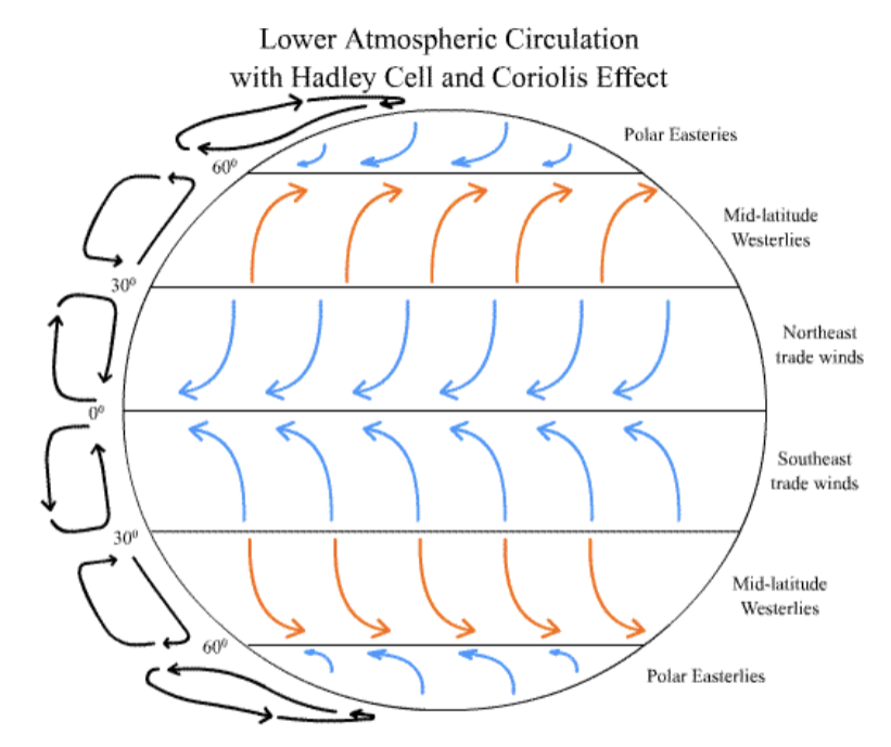
Desert Location Determined by Patterns of Atmospheric Circulation
warmest at equator
coldest deserts at top or bottom
Trade Winds
0-30 degrees
air moves toward the equator but curves west
east to west
descending cool, dry air
rising warm, moist air
Westerlies
30-60 degrees
air moves towards the poles but curves east
west to east
rising warm, moist air
Polar Easterlies
60-90 degrees
cold air flows outward & curves west
east to west
descending cool, dry air
Wet Winds
wind that blows over oceans picks up water vapor
rising air cools and can’t hold as much moisture
warm air holds moisture
Dry Winds
winds that come from continents
sinking air warms and holds moisture
cold air holds little moisture
What are the types of deserts?
Subtropical
Sahara
Continental Interior
Gobi Desert
Rainshadow Deserts
Mohabbi Desert
How does wind transport sediments?
Saltation
Suspension
Creep
What is saltation?
a specific way wind moves sand-sized particles along the ground; bouncing motion
lifted off the ground
travels short distance through air
falls back down
What is suspension?
when very fine particles (dust or silt) are lifted & carried in the air for long distances
wind picks up tiny particles from surface
turbulence keeps them from settling
travel high in the atmosphere & can move hundreds-thousands of miles
What is creep?
movement of the largest & heaviest sediment particles
instead of being lifted in the air particles roll or slide along surface
move slowly & stay in constant contact with ground
pushed by wind indirectly
Is the wind efficient in moving sediments around?
least efficient
What are the types of wind erosion?
deflation
abrasion
What is deflation?
removal of loose material by wind
What is abrasion?
near surface effect caused by impact of saltating sand grains
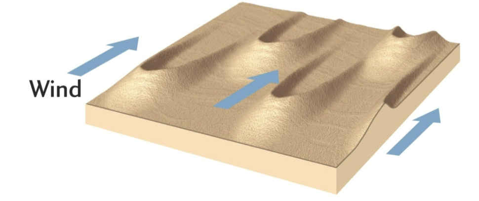
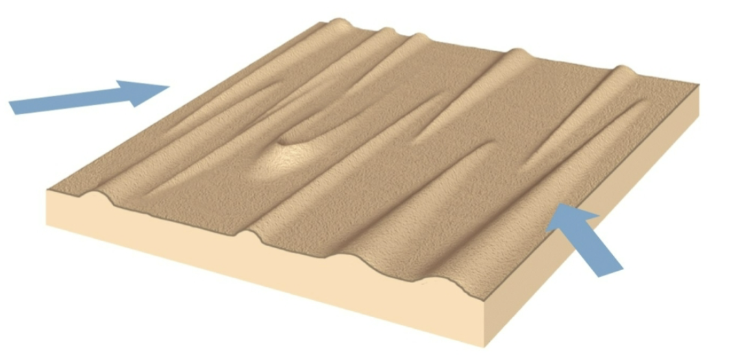
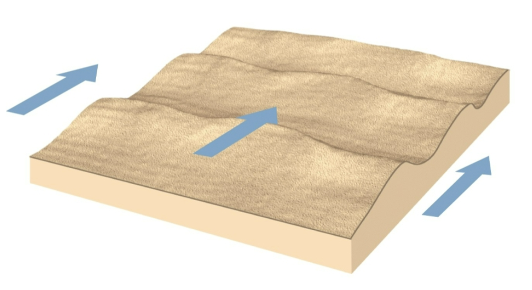
What are the types of sand dunes?
barchan
parabolic
longitudinal
transverse
What are barchan sand dunes?
crescent shaped
tips point downwind
in areas that are flat & dry
little vegetation
limited supply of sand
constant wind direction
What are parabolic sand dunes?
crescent shaped
tips point upwind
commonly in coastal areas with strong onshore winds
abundant sand
partial cover of vegetation
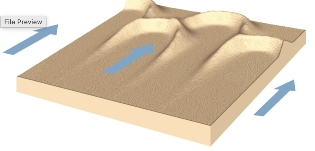
What are longitudinal sand dunes?
long, parallel ridges
aligned parallel to the wind direction
winds generally converge from slightly different directions
30-100 m high; 100 km long
What are transverse sand dunes?
long ridges
perpendicular to the wind direction
sand seas
200 m high; 3 km wide
What is desertification?
a type of land degradation in which a relatively dry land region becomes increasingly arid, typically losing its bodies of water as well as vegatation & wildlife
What is desertification caused by?
climate change
human activities
What are waves created by?
wind energy
What are swells?
storm waves
What is wavelength?
distance between crests
What is wave height?
the vertical distance between the trough and crest
What is a period?
time required for one wavelength to pass a set point
What is a wavebase?
½ of wavelength
What is wave refraction?
waves bend as they encounter shorelines
What is the overall goal of wave refraction?
to make shoreline flat & smooth
What are tides created by?
gravitational attraction between the Earth and Moon that pulls water toward the moon
What are spring tides?
moon and sun line up twice a month to produce higher than average tides
What are neap tides?
when the moon is in the 1st and 3rd quarter, the moon and sun are working against each other to produce lower than average tides
What are tidal surges?
abnormal rises in sea level caused by strong storms not by normal daily tides
What are the types of tidal currents?
flood tides
ebb tides
What are rip currents?
strong, narrow channels of water that flow away from the shore pulling water back out to sea
What are the features of a shoreline?
beaches
offshore, foreshore, backshore
erosion & coastal forms
depositional coastal forms
What are the types of erosion & coastal forms?
stacks
wave-cut terraces
sandy beaches
What are the types of depositional coastal forms?
spits
barrier islands
What are stacks?
tall isolated pillars of rock standing just offshore formed by the erosion of cliffs
What are wave-cut terraces?
flat, gently sloping rock surfaces found at the base of coastal cliffs created by wave erosion over time
What are sandy beaches?
coastal landforms made of loose sand that has been deposited along the shoreline
What are spits?
long, narrow ridges of sand or shingle that extend out from the coastline into the sea, formed by deposition
What are barrier islands?
long, narrow islands made of sand that run parallel to the mainland coast formed by deposition of sediment by waves, tides, & currents
What are the types of continental margins?
passive
active
What are passive continental margins?
coastal regions where a continent meets the ocean but is not located at an active plate boundary
no subduction zones
What are active continental margins?
coastal regions where a continent meets the ocean at a plate boundary
tectonically active
What is the order of shoreline features? (closest to furthest from shore)
coastal plain
continental shelf
continental slope
continental rise
sea floor
Coastal Plain
a broad, flat or gently sloping area of land next to the ocean formed by long-term deposition of sediments and/or a retreating shoreline
Continental Shelf
the shallow, gently sloping underwater edge of a continent that extends from the shoreline out to the deep ocean
broad, flat plains of sand & mud
shelf-slope break
Continental Slope
the steeply sloping zone that connects the continental shelf to the deep ocean floor
Continental Rise
gently sloping zone at the base of the continental slope
What is at the seafloor?
abyssal plain
seamounts, volcanoes, & guyots
reefs
What is the abyssal plain?
the very flat, deep part of the ocean floor found beyond the continental rise
What are glaciers?
systems of ice originating on land through the accumulation and recrystallization of snow
What are the 3 types of glaciers?
valley glaciers
continental glaciers
piedmont glaciers
What are valley glaciers?
originates high on a mountain and moves downward through preexisting valleys
cirque glaciers are special types of valley glaciers that occupt an erosional feature that is cut into bedrock and is bowl shaped
What are continental glaciers?
a slow-moving ice sheet that resembles a giant dome several thousand meters thick in the center and sloping down toward sea level on all sides
What are piedmont glaciers?
found at the foot of a mountain & occur when valley glaciers come out of mountains and join the foot of a mountain
Where do glaciers form?
in areas where winter snowfall exceeds summer melting
zone of accumulation
Describe the process of glaciers forming
does not require year-round snowfall, only cold enough to have snow exist through the summer
the weight of accumulating snow compress lower layers into glacial ice
as the ice accumulates it begins to flow
the glacier also loses ice
zone of ablation
What does the balance of ice ablation & accumulation have to do with whether the glacier is standing still or shrinking?
if the glacier is standing still accumulation = ablation
glacier is neither gaining nor losing overfall mass
if the glacier is shrinking ablation > accumulation
more ice is melting or breaking off than being replaced
How do glaciers move?
basal sliding
creep
ice flow due to crevasses
What is basal sliding?
the process where a glacier moves by slipping over the ground beneath it
What is creep?
the slow internal deformation of ice where the glacier moves by the ice itself changing shape under pressure rather than sliding over the ground
Valley Glaciers
long, narrow glaciers that form in mountain valleys and flow downhill like slow-moving rivers of ice
Continental Glaciers
very large, thick masses of ice that cover vast areas of land including entire regions or continents
What are the features of glacier systems?
striations
erratics
drumlins
eskers
kettle lakes
moraines
outwash plain
What are striations?
long, parallel scratches or grooves cut into bedrock by a moving glacier
What are erratics?
large rocks or boulders that have been transported and deposited by a glacier, often far from their original location
What are drumlins?
elongated, smooth, hill-shaped mounds of glacial till that were formed under moving ice sheets
What are eskers?
long, winding ridges of sand and gravel deposited by meltwater streams flowing beneath a glacier
What are kettle lakes?
small, often circular lakes that form when blocks of ice left behind by a retreating glacier melt and leave a depression in the ground
What are moraines?
accumulations of unsorted sediment called till that are deposited directly by a glacier
What are outwash plains?
broad, flat areas of sand and gravel deposited by meltwater flowing out from a glacier
What are the types of valley glaciers?
aretes
cirque
horn
hanging valley
truncated spurs
terminus
moraines
lateral moraine
medial moraine
What is a river?
a stream runoff is an important geolgic agent
erodes, transports, & deposits ion and sediments
sculpts landscapes
transfers mass from continents to oceans basins
What is the anatomy of a river system?
head or headwaters
trunk or channel
mouth
What is a head or headwater?
the uppermost part of a river where it begins
What is a trunk or channel?
the primary river channel that carries water from tributaries toward the river’s mouth
What is a mouth?
the end point of a river where it flows into a larger body of water
Are rivers effective in changing landscapes?
yes because they are always moving
erosion & deposition never stop
landscapes are changing relatively quickly in response to moving water
What are stream valleys?
elongated low-lying areas of land carved out by the long-term erosion of a river or stream
What are floodplains?
flat, low-lying areas of land next to a river that are regularly flooded when the river overflows its banks
How does erosion occur?
abrasion
chemical & physical weathering
undercutting
What is abrasion?
a process of erosion where rock and sediment carried by wind, water, or ice scrape, & grind against a surface, wearing it away over time
What is chemical & physical weathering?
physical: the breaking of rock into smaller pieces without changing its chemical makeup
chemical: the breakdown of rock through chemical reactions that change its composition
What is undercutting?
a process of erosion where the base of a slope, riverbank, or cliff is worn away faster than the upper part causing the structure above to become unstable
What are the factors of global climate change?
composition of atmosphere
amount of solar radiation
effect of oribital paramters
atmospheric/oceanic circulation
interactions with biogeochemical cycles
albedo of earth
catastropic effects
human impacts
What is a warming loop?
something that causes warmer conditions
as a result some snow and ice melts
this lowers the surface albedo
lower albedo causes more solar radiation to be absorbed at the surface
more absorption of solar radiation causes warmer conditions
What is a cooling loop?
something causes colder conditions
as a result some more snow and ice forms on the surface
the raises the surface albedo
higher albedo causes less solar radiation to be absorbed at the surface
less absorption of solar radiation causes cooler conditions