AP HUG unit 1 review
1/74
There's no tags or description
Looks like no tags are added yet.
Name | Mastery | Learn | Test | Matching | Spaced | Call with Kai |
|---|
No analytics yet
Send a link to your students to track their progress
75 Terms
Focus of Human Geography
The study of how humans use space and organize activities, and why those patterns exist in specific locations.
Why of Where
The idea of explaining why something is located where it is and why that location matters.
Carl Sauer
A geographer who argued that humans shape the environment, creating cultural landscapes.
Cultural Landscape
The visible human-made features on Earth's surface resulting from human activity.
Derwent Whittlesey
A geographer who developed sequent occupance, explaining cultural change over time.
Sequent Occupance
The process in which different groups occupy the same place over time, altering the landscape.
John Snow
A geographer who used maps to track disease spread and identify health patterns.
Ellsworth Huntington
A geographer who supported environmental determinism, linking environment to human behavior.
Environmental Determinism
The belief that environmental conditions directly control human behavior, limiting human choice.
Possibilism
The belief that humans modify the environment using technology, not controlled by it.
Wilbur Zelinsky
A geographer who created the Mobility Transition Model explaining migration patterns.
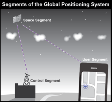
GPS (Global Positioning System)
A satellite system that determines exact absolute location on Earth.
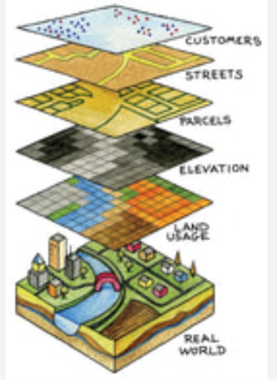
GIS (Geographic Information Systems)
A computer system that stores and analyzes layered spatial data.
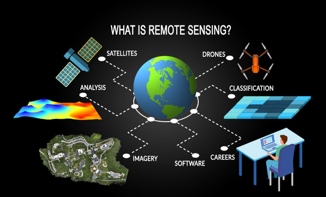
Remote Sensing
The collection of geographic data by satellites or aircraft from a distance.
Census
A government count collecting population and demographic data for planning and representation.
Large-Scale Map
A map showing a small area with detailed information.
Small-Scale Map
A map showing a large area with limited detail.
Scale of Analysis
The level at which geographic data is examined, from local to global.
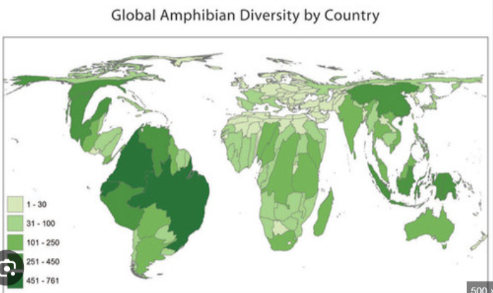
Choropleth Map
A thematic map using color shading to show data values, usually rates or percentages.
Dot Distribution Map
A map using dots to show spatial distribution patterns.
Proportional Symbol Map
A map using symbol size to represent data quantity.
Cartogram
A map where area size is distorted to represent data.
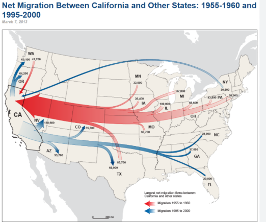
Flow-Line Map
A map showing movement between places using lines.
Latitude
Horizontal lines measuring distance north or south of the Equator.
Longitude
Vertical lines measuring distance east or west of the Prime Meridian.
Site
The physical characteristics of a location, including land and resources.
Situation
A place's location relative to other places or routes.
Mathematical Location
The exact location using latitude and longitude coordinates.
Formal Region
A region defined by shared physical or cultural characteristics.
Functional Region
A region organized around a central node or hub.
Vernacular Region
A region defined by people's perceptions and cultural identity.
Distance Decay
The idea that interaction decreases as distance increases due to time or cost.
Time-Space Compression
The reduction of travel time and perceived distance through technology.
Tobler's First Law
The idea that nearby places are more related than distant places.
Clustered Pattern
A spatial pattern where objects are grouped closely together in one area.
Dispersed Pattern
A spatial pattern where objects are spread out with large distances between them.
Local-Global Continuum
The idea that local actions can affect global systems and vice versa.
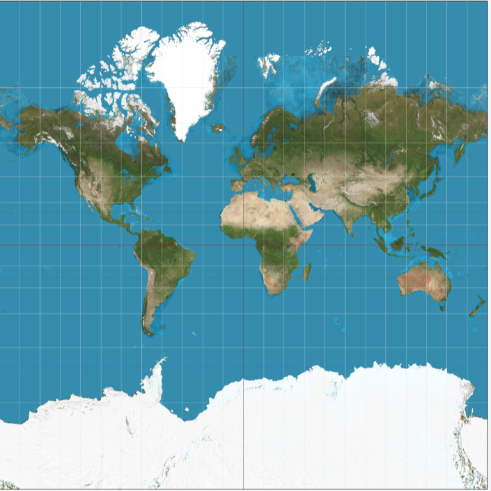
Mercator Projection
A map projection that preserves shape and direction but greatly distorts size near the poles.
Peters (Gall-Peters) Projection
A map projection that preserves relative area but distorts shape, making continents appear stretched.
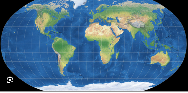
Robinson Projection
A compromise projection that minimizes overall distortion but preserves no single feature perfectly.
Goode's Homolosine Projection
A projection that preserves land area and shape but interrupts oceans, creating a split appearance.
Azimuthal Projection
A circular projection that preserves direction from a central point, often the poles.
Conic Projection
A projection that preserves shape in mid-latitude regions, commonly used for the United States.
What map projection is this?
Mercator projection
What map projection is this?
Peters (Gall-Peters) Projection
What map projection is this?
Robinson Projection
What map projection is this?
Goode's Homolosine tangerine projection
What map projection is this?
Azimuthal Projection
What map projection is this?
Conic projection
Cartography
The art and science of mapmaking
What type of map is the mercator map? Cylindrical, conic, or planar?
Cylindrical
Reference Map
A map that shows general geographic information such as locations, boundaries, and physical features.
Thematic Map
A map that shows the spatial distribution of one specific topic or data variable.
World System's Theory
Theory how the world exists as a single socio-economic system made of core, semi-periphery, and periphery regions.
According to AP Classroom materials, both GPS and GIS depend on and use what for navigation?
Real time data for navigation and geospatial technologies
LIDAR
A plane that uses a laser to project a 3d model of a landscape.
Aerial photography and satellite imagery are types of remote sensing.
True because they both collect data without touching the Earth's surface.
Remote Sensing
Collecting geographic data from satellites or aircraft without direct contact with Earth's surface.
Aerial Photography
Photographs of Earth's surface taken from aircraft or drones; a type of remote sensing.
Satellite Imagery
Images of Earth collected by orbiting satellites; a type of remote sensing.
Census
An official government count collecting population and demographic data.
Field Observation
Collecting data by directly observing and recording conditions in a location.
Surveys and Questionnaires
Gathering geographic data by asking people questions about behaviors or characteristics.
Interviews
Collecting qualitative geographic data through in-depth conversations.
Government and Institutional Records
Using data collected by governments or organizations for geographic analysis.
Something as small as a school zone, can be considered as what type of region? Formal, functional, or perceptual?
Formal region
What’s the difference between describing a site vs a situation of a place?
Site are things that cannot really be changed like the climate, natural landform, and elevation.
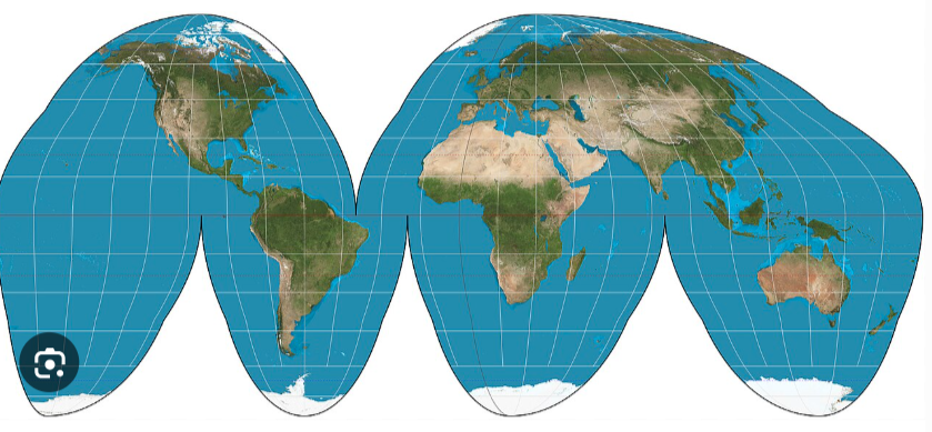
What type of map is the goode homosoline projeciton?
Equal area projection
Is the goode homosoline projection used in mid- latitude countries?
No, mid latitude countries use the cone projection the most.
Region
An area with a specific, homogenous characteristic.
Biome
An area according to the species inhabiting it.