GE-101 Introduction to Geography - Atmospheric and Oceanic Systems
1/85
Earn XP
Description and Tags
Practice vocabulary flashcards based on the GE-101 Introduction to Geography Second Long Exam transcript, covering earth systems, meteorology, and oceanography.
Name | Mastery | Learn | Test | Matching | Spaced | Call with Kai |
|---|
No analytics yet
Send a link to your students to track their progress
86 Terms
Natural Greenhouse Effect
A phenomenon persisting for billions of years that helps regulate Earth's global temperature, preventing it from freezing and maintaining it in-check.
The occurrence of an El Niño/La Nina has NO effect on the ocean productivity and the world food sustainability
False
Air Flows from areas of lower pressure to areas of higher pressure
False
Air flows from areas of higher pressure to areas of lower pressure
EASTERLIES/TRADE WINDS are the dominant WEST-TO-EAST motion of the atmosphere
False
Easterlies or trade winds move east to west
Water exists in four states: Liquid, Solid, Gaseous, and Plasma states
False
Only three states: Solid, liquid, and gaseous
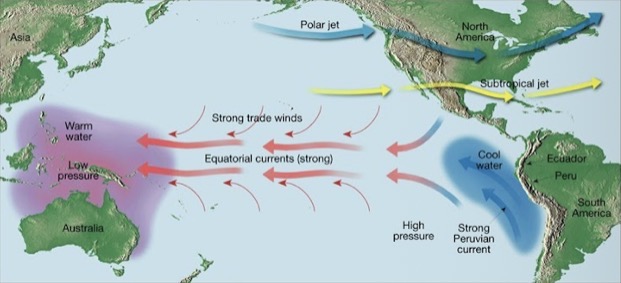
The Figure below portrays an El Nino condition of the Pacific Ocean, where warm waters are seen in the western Pacific (near Asia) and cool ocean waters are upwelling in the eastern side of the Pacific (near North and South America)
False
The figure portrays normal conditions
Friction acts to slow air movement which changes wind direction
True
Earth's climate and weather are primarily driven by the heat from the sun and consists of an endless series of heat transfers from the oceans to the atmosphere and vice versa
True
Hurricanes, typhoons and cyclones are all rotating storms spawned in the tropics. Because of the Coriolis effect, these storms rotate CLOCKWISE in the Northern Hemisphere
False
They rotate COUNTER-CLOCKWISE in the northern hemisphere
The earth’s axis tilt of 23.5° is one of the major causes of changes in earth’s seasons
True
Coriolis Effect
An effect where Earth's rotation causes free-moving objects or fluids to be deflected to the right in the Northern Hemisphere and to the left in the Southern Hemisphere.
The Coriolis Effect is an actual force that makes things (like planes or currents of air) traveling long distances around Earth appear to move at a curve as opposed to a straight line
False
The spherical nature of the surface of the earth is another reason for the difference in heating of the hemispheres causing the seasons
True
The more dominant type of breeze during the NIGHT TIME is the Sea Breeze, where the land HEATS/WARMS faster than the ocean, and air rises on the shore
False
The sea breeze is the dominant breeze during the DAY TIME
The north and south poles receive the most concentrated solar radiation due to the Earth's' curvature
False
The tropics receive the most concentrated radiation
In coastal areas during the warm summer months, the land surface is heated more intensely during the daylight hours than an adjacent body of water (such as an ocean). As a result, the air above the land surface heats, expands, and rises, creating an area of lower pressure. At night the reverse takes place
True
Air Pressure
A phenomenon exerted by the weight of air in all directions—down, up, and sideways.
Jet streams flow from EAST-TO-WEST directions in both the northern and southern hemispheres
False
Jetstreams flow from WEST-TO-EAST
Clouds are basically water in its liquid state
True
An ANEMOMETER is a weather instrument that measures HUMIDITY in the air
False
Anemometers are used to measure wind speed
The heat transport within the Earth's ocean is driven by the different distributions of Salinity and Temperature
True
Air that is heated or warmed would tend to sink
False
Heated or warmed air rises
Cold air generally holds lower moisture
True
The Figure portrays a normal condition of the Pacific Ocean, where warm waters from western Pacific move towards the eastern Pacific, preventing the upwelling of cold waters in the eastern side of the Pacific
False
The figure portrays an El Niño event
The unequal heating of Earth’s surface generates pressure differences in the atmosphere
True
Solar radiation is the ultimate energy source for most wind
True
Thunderstorms and Lightning help regulate the electrical balance between the atmosphere and the planet
True
Fog is a high-lying form of cloud
False
Fog is a low-lying form of cloud
It is postulated that the burning of fossil fuels at the start of the industrial era (some 200 years ago) until now, has contributed to the accumulation of carbon dioxide and other "greenhouse gases". As a result of this accumulation, long wave radiation (which is heat) is prevented from escaping into space thereby increasing global temperature
True
Orographic precipitation, such as rain, snow, or other precipitation are produced when moist air is lifted as it moves over a mountain range. As the air rises and cools, orographic clouds form and serve as the source of the precipitation, most of which falls upwind or windward side of the mountain ridge
True
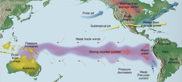
The term El Nino was coined by the fisher folks of South America, to the Christmas season which is the birth of the baby Jesus
True
The more dominant type of breeze during the day is the Land Breeze, in which the land COOLS faster than the ocean, and where air rises offshore
False
The land breeze is the dominant breeze during the NIGHT TIME
The highest amounts of long-wave radiation or heat from earth have been observed to be at the poles
False
They were observed in the tropics
Warm air generally holds higher moisture
True
The occurrence of an/a El Nino/La Nina happens from between 3 to 7 years cycle
True
The eye of a storm is a high pressure area
False
The eye is calm and surrounded by higher pressure and intense winds
Because of the Coriolis effect, the storms rotate COUNTERCLOCKWISE in the Southern Hemisphere
False
Storms rotate clockwise in the southern hemisphere
The El Nino phenomenon was first observed and most strongly observed in the waters of the Atlantic Ocean
False
El Niño was first observed in the Pacific Ocean
Wind
The result of horizontal differences in air pressure, with solar radiation acting as the ultimate energy source.
Westerlies in the tropics are the same or synonymous to the Trade winds
False
EASTERLIES are synonymous to trade winds
Most of the surface freshwater on earth are to be found in the frozen state in ice caps and glaciers
True

Identify the types of atmospheric lifting (L)
Conventional
Unequal heating of earth’s surface causes air to rise
Trade Winds (Easterlies)
Two belts of winds that blow almost constantly from the east towards the western directions, located on the north and south sides of the subtropical highs.
Westerlies
The dominant west-to-east motion of the atmosphere that characterizes the regions on the poleward side of the subtropical highs.
Anemometer
A weather instrument that resembles a cup and is commonly used to measure wind speed.
Psychrometer
An instrument consisting of a wet bulb and a dry bulb thermometer used to determine atmospheric humidity.
Barometer
The instrument used for measuring air pressure.
Relative Humidity
The amount of water vapor in the air expressed as a percentage relative to the maximum amount the air can hold at a given temperature.
Subsolar Point
The location where the sun's rays are perpendicular (at right angles) to the Earth's surface.
Insolation
Solar radiation that reaches a horizontal plane at the Earth's surface.
El Niño
The periodic warming of the ocean that occurs in the central and eastern Pacific, occurring in a cycle of 3 to 7 years.
Monsoons
Seasonal reversal of wind direction associated with large continents like Asia, where wind blows from land to sea in winter and sea to land in summer.
Occur on a “mega-scale” or “continental scale”
Jetstream
Fast-moving "rivers" of air that travel between 120 and 240 kilometers per hour in a west-to-east direction.
Intertropical Convergence Zone (ITCZ)
A belt of low pressure circling the Earth near the equator where the trade winds of the Northern and Southern Hemispheres meet; also known as the Doldrums.
Sublimation
The process of ice water turning into its gaseous form without necessarily going through a liquid phase.
Orographic Precipitation
Precipitation produced when moist air is lifted over a mountain range, cooling to form clouds mostly on the windward side.
Gulf Stream
The main oceanic current that regulates most of western Europe, providing relatively mild winters compared to the rest of the continent.
Summer Solstice
Occurs every June 20 to 23 in the northern hemisphere, featuring the longest day and shortest night of the year.
Winter Solstice
Occurs every December 20 to 23 in the northern hemisphere, featuring the longest night and shortest day of the year.
Spring Equinox
Occurs around March 20 to 23 when both hemispheres experience equal day and night lengths of 12 hours.
Autumnal Equinox
Occurs every September 20 to 23 when both hemispheres experience equal day and night lengths of 12 hours.
Cyclones
Centers of low air pressure.
Typhoon Development (Stage 1)
Heating of the oceans from the solar radiation.
Typhoon Development (Stage 2)
Warm moist air rises above the warm oceans.
Typhoon Development (Stage 3)
Creation of a low pressure (air of less weight) around the area where warm air rises.
Typhoon Development (Stage 4)
The rising moist air cools at high altitudes and forms clouds, often resulting in precipitation like rain.
Typhoon Development (Stage 5)
Coriolis effect kicks in as the Earth rotates and the cloud mass starts to spin and rotate around the low air pressure.
Sea Breeze
A breeze dominant during daylight hours where land heats faster than the ocean, causing air to rise on shore and creating lower pressure.
Land Breeze
A breeze dominant at night where air above the sea is warmer than the land, causing air to expand and rise offshore.

In the figure identify the cell labeled (P)
Ferrel Cells
What type of Front is the Figure below?
Cold Front
Denser, cooler air force’s less dense, warmer air to rise
At higher altitudes such as at the summit of Mount Everest, there is _______ air pressure than at sea level
Less
At high altitudes during air flight, bag of chips would usually bloat from its normal size. Why do you think this is happening?
At higher altitudes, the air pressure outside the bag is lower
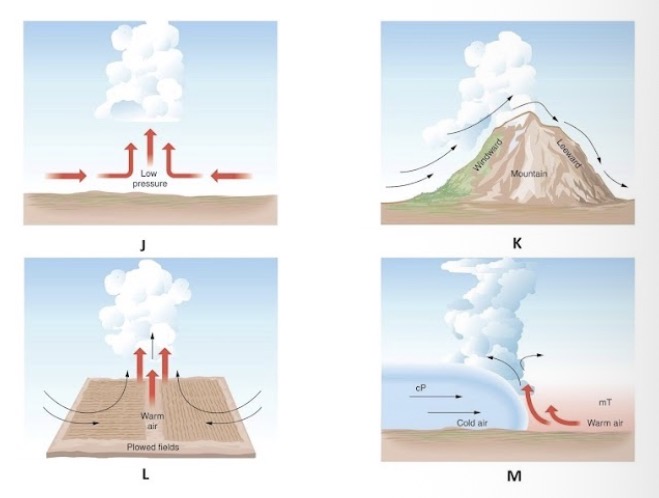
In figure, identify the type of atmospheric lifting in (M).
Frontal

In figure above identify the type of atmospheric lifting in (K).
Orographic

In figure, identify the type of atmospheric lifting in (J)
Convergent
Air/ wind from different directions collide and force each other to rise
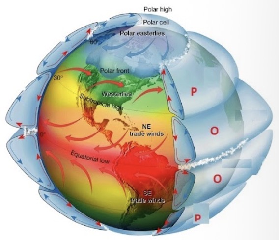
In the figure identify the cell labeled (O)
Hadley Cells
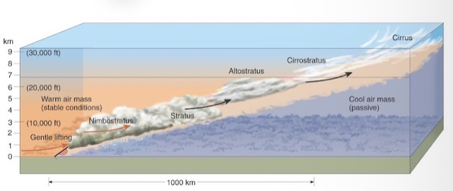
What type of Front is the Figure below?
Warm Front
Less dense, warmer air rises OVER denser, cooler air
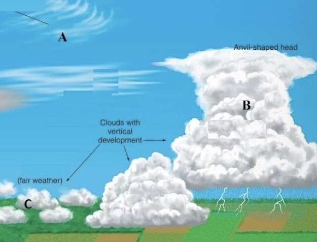
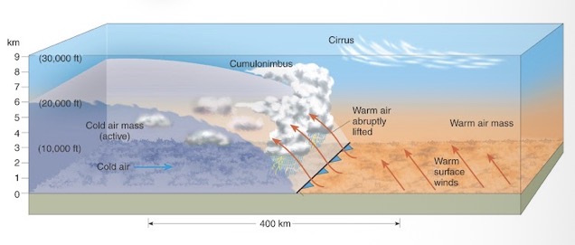
In the figure, identify the cloud type labelled (C)
Cumulus
Fluffy, cotton-like
At lower altitudes such as at sea level, there is _______ air pressure than at higher altitudes such as at the summit of Mount Everest
Higher
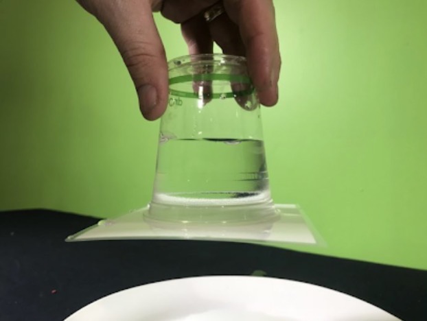
The water glass experiment shown in class demonstrates a clear fact that
Air pressure OUTSIDE the glass is HIGHER that it counters the weight of the water and prevents the water from spilling out
_____ occurs where the air above the surface of the sea is warmer than the land surface, and the air expands and rises creating an area of lower pressure, This is the more dominant breeze during night time.
Land breeze, breeze coming from land out toward the sea
That portion of the earth where the highest amounts of long-wave (or heat) radiation have been observed all-year round, at maximum latitudes 30 degrees North and South, is called ________
The tropics

In the figure, identify the cloud type labelled (B)
Cumulonimbus
In coastal areas during the warm summer months, the land surface is heated more intensely during the daylight hours than an adjacent body of water is heated. As a result, the air above the land surface heats, expands, and rises, creating an area of lower pressure. This is the more dominant breeze during day time
Sea breeze, breeze coming from the sea moving in-land

In the figure, identify the cloud type labelled (A)
Cirrus