Lectures 3 & 4 - Short term forecasting
1/31
There's no tags or description
Looks like no tags are added yet.
Name | Mastery | Learn | Test | Matching | Spaced | Call with Kai |
|---|
No analytics yet
Send a link to your students to track their progress
32 Terms
What is short term forecasting essentially about?
What will the weather be in the coming 6-48h?
What is the most important tool for short term forecasting?
Regional NWP
What are some properties of regional NWP models?
Highest possible resolution for representing mesoscale weather + topography
frequent data-assimilation cycles with latest observations
model output quickly available
recent years: RUC (rapid update cycles 1 hourly ensembles, blending between hours 2 and 6 with nowcast systems)
Explain what “nesting” is?
Running regional NWP still requires, less-frequently-updating, slower models to provide boundary conditions
Which two regional NWP models are run by GeoSphere?
AROME, C-LAEF
What is the AROME-AUT model?
deterministic, best guess initial and boundary conditions
dx = 2.5km
90 vertical levels (30m resolution in the lowest 1km)
3 hourly
lead time: 60h
What is C-LAEF?
16 member ensemble version of the AROME model
dx: 2.5km
12 hourly
Lead time: 60h
pertubed physics, initial and boundary conditions
What is the difference between grid resolution and effective resolution?
effective resolution: what the model can resolve
grid resolution: what the grid spacing is in the model
effective resolution is ~10x greater than grid resolution
What are the grid resolutions of AROME, CLAEF, ICOND2?
dx= 2.5km, 2.5km, 2.2km
What does AROME stand for?
Application of Research to Operations at MEsoscale
What are two key features of AROME?
Non-hydrostatic
No parameterized deep convection
How long does AROME-AUT need to run a full forecast?
3+ hours
Waiting for data to become available ~100min
Data assimilation ~15min
Time integration ~25min
What is the idea of an Ensemble?
Turn deterministic (single) NWP into probabilistic forecast by running it multiple times
Which variations are introduced to create an ensemble?
Initial conditions (measurement uncertainty)
Boundary conditions (uncertainty from the parent model)
Model physics pertubations (radiation, shallow convection, turbulence, microphysics)
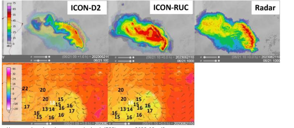
How do Rapid Update Cycles (RUC) work?
hourly runs that incorporate the latest radar observation, already operational at some national weather institutes
How is Forecast uncertainty definied?
Forecasting is all about quantifying (un)certainty of specific weather types
Uncertainty is an essential part of the warning-based forecasting
High certainty x High impact = high-end warning
Which two possibilities exist for estimating uncertainty in forecasts?
Ensemble forecast systems
Conversion of deterministic into an ensemble using spatial and/or temporal filters
What can be used to estimate the maximum potential of precipiation events?
ensembles
What can the ensemble median be used for regarding precipitation?
helps identifying regions of risk of flooding
How does uncertainty of an ensemble evolve with time?
it grows over time
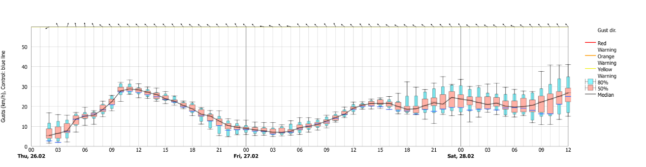
what is the best methods to gauge forecast uncertainty?
using ensemble systems
What are the two most important short term forecast products?
2D Maps
Meteograms
What is a strength of regional NWP?
Resolution compared to medium range forecasts
What would need to be the grid resolution of a model to resolve a thunderstorm (horizontal ~ 1km)?
100m resolution or finer ignoring well representing all physics at these scales
How does vertical resolution look like with increasing height?
Grids are typically increasing in vertical resolution with height,
near surface resolution is approximately 20m
30 levels in the lowest 1km (~33m)
10 levels from 1 - 2km (~100m)
remaining 50 levels to the stratosphere (~30km)
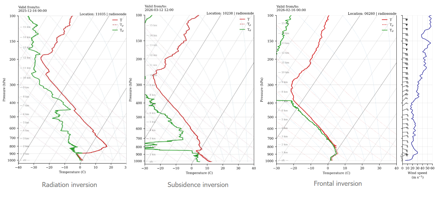
which three types of inversions do exist?
radiation inversion
subsidence inversion
frontal inversion
On what does the error of temperature and wind forecasts depend?
Orography
time of year
time of day
Which models are better in flat terrain? Regional vs global models
In flat land regional high resolution models are hardly better than global models
Which models are better in mountainous terrain? Regional vs global models
in complex terrain AROME can beat IFS
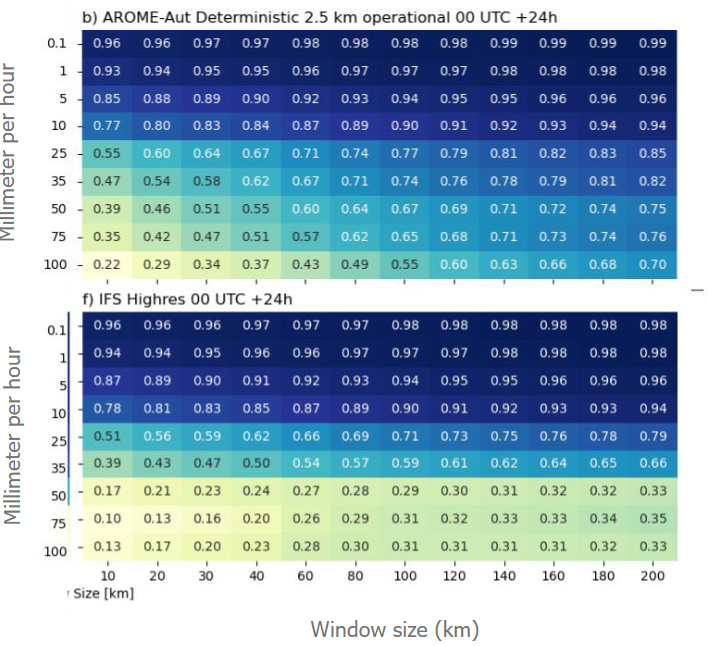
Which is better, AROME or IFS, for precipitation <10mm/h?
both are useful on all scales
Which is better, AROME or IFS, for precipitation >10mm/h?
Beyond 10mm/h AROME is best across all scales
What are typical grid scales for regional NWP models?
1-3km horzontal resolution