Option G: Urban Environments
1/56
There's no tags or description
Looks like no tags are added yet.
Name | Mastery | Learn | Test | Matching | Spaced | Call with Kai |
|---|
No analytics yet
Send a link to your students to track their progress
57 Terms
Define site
The physical location and geographical characteristics of a settlement
Define urbanisation
An increasing proportion of a country's population living in towns and cities
Define situation
The location of a place relative to other areas and the relationships that influence its development
HOS: Define range
The maximum distance people are prepared to travel for a good or service
HOS: Define threshold
The minimum number of people required for a good or service to stay in business
HOS: Define sphere of influence
The area served by a settlement
What is a megacity?
A city with a population of over 10 million inhabitants
Compare low- and high-order goods
Low-order goods - Everyday items bought frequently & widely accessible
High-order goods - Luxury goods bought or used infrequently
Describe factors for change in retail hierarchy (6)
1) Population change - e.g. aging population
2) Suburbanisation of wealthier households
3) Technological changes
4) Economic change - e.g. higher wages to afford luxuries
5) Congestion
6) Social changes - e.g. more employed women
Describe factors affecting distribution of residential areas (4)
Examples | |
Physical Factors | Forced/voluntary proximity to:
|
Ethnicity |
|
Planning | HICs:
LICs:
|
Proximity to CBD | Density & space - Closer to CBD = more dense, high-rise buildings VS Farther = less dense, larger homes Property values - Closer = higher price due to accessibility demand VS Farther = more affordable for different incomes Access to services & infrastructure - Closer = Better transport, healthcare, education, entertainment VS Farther = Less access, longer commutes |
Describe factors for distribution of economic activity (commercial, retail, industrial) [7]
Factor | Explanation for positive |
Relief (I) | Flat land → facilitates expansion + construction of infrastructure, utilities (electricity, water) |
Coasts (C) | Allows development of commerce + port-related activities (e.g. transporting cargo) |
Geology (I) | Proximity to mines → mineral resources can be manufactured & sold |
Market (R, C) | Proximity to settlements → ⬆ consumer spending |
Labour (I) | Access to labour pool → unskilled = cheap (esp. in LICs) |
Transport links (R, C, I) | Accessibility to roads, rails, & airports → Shorter commutes for travel or delivery of raw materials/goods |
Land value/rent (R, C, I) | Cheaper = more sustainable long-term; varies with seasonal revenue |
Define informal economy
Economic activities outside official regulations that provides livelihoods for urban residents
Describe the pros and cons of an informal economy (6)
Pros | Cons |
Provides jobs for often underrepresented people (un/semi-skilled & migrants) | Associated with negative activities (e.g. drugs, bribery, smuggling)
|
Less time and money to set up businesses | Limited access to credit due to unregulated nature of the business |
Goods produced often not in competition
| Health & safety risks for employees due to poor work conditions
|
Describe the causes of urbanisation (3)
A greater proportion of a people living in urban areas, caused by:
1) Rural-urban migration
2) Natural increase (CBR - CDR)
3) Urban sprawl, where there is a reclassification of rural areas into urban ones
Define centripetal movement
Movement of a population and economic activity from the periphery to urban centres
State examples of centripetal movement
1) Rural-urban migration
2) Gentrification
Define rural-urban migration
A relocation of individuals from rural to urban areas
Define gentrification
Rehabilitation of deteriorated inner-city areas, especially residential housing and commercial spaces
Describe consequences of gentrification (4)
1) Displacement of older & poorer demographic
2) Influx of younger & richer people/businesses → initial low rent + closer to CBD
3) Small-scale businesses forced out
4) Increased land price
What is a Brownfield site?
Land previously used for industrial/commercial purposes that were abandoned or underutilised
If this land is contaminated, it requires environmental remediation before redevelopment
Define centrifugal movement
Movement of a population and economic activity from the centre of the urban area to its periphery
State examples for centrifugal movement (3)
1) Urban sprawl
2) Suburbanisation
3) Counter-urbanisation
Define urban sprawl
The unplanned physical expansion of a city area into the surrounding countryside
Define suburbanisation, & describe its features
The outward expansion of towns & cities, that engulfs surrounding villages/rural areas
Define counter‑urbanisation
The movement of population away from inner urban areas to towns/villages on the city’s edge or beyond the rural-urban fringe
Define deindustrialisation
Long-term decline in employment in an economy’s manufacturing sector
Compare positive vs negative deindustrialisation
Positive deindustrialisation - When industries replace workforce w/ machinery
Negative deindustrialisation - When the number of workers in an industry decline but productivity/machanisation doesn’t rise
Describe causes of deindustrialisation (3)
1) Globalisation - companies produce in countries w/ lower costs, rely on cheaper imports > local manfucaturing
2) Technological advancements - machines replace human labour for efficiency
3) Urban land - high prices + lack of space push industries to suburban/rural areas
Describe consequences of deindustrialisation (6)
Economic:
Rising unemployment
Increased taxes
Social:
Lack of job opportunities → poverty & inequality
Increased crime rate
Demographic:
Out-migration / brain drain → job gaps + unskilled workers dominate
Ageing population → youth migrates for opportunities
[CS] Infrastructure growth - Shanghai, China (8)
Urban growth challenges:
Population surged from 11 million in 1978 to 24 million in 2015
Problems like congestion, pollution, housing shortage arose from inadequate infrastructure
Congestion - Narrow roads caused 2-hour rush jams
Pollution - Huangpu River contaminated by industrial/household waste + ~ 80% of untreated sewage
Housing shortage - In 1990s, 13 million crammed in compounds owned by state-owned enterprises BUT lack of maintenance 📉 living standards + when factories closed, 2-3 million workers displaced
Mitigation strategies (infrastructure):
Transport - Metro system eased congestion → carries over 10 million passengers daily
Water & sanitation - 200+ wastewater plants to treat sewage, contributing to 80% reduction in water pollution to present
Public housing - Economic Applicable Housing offered to displaced workers → meet basic necessities for better health
Define a suburb
A residential area within or just outside the boundaries of a city
Define microclimate
Any local deviation from the climate of a larger area
Describe reasons for a microclimate (5)
1) Changed surface qualities - (Pavements & buildings) Increased absorbance or reflection of solar radiation, reduced evaporation
2) Buildings - Casting a shadow, acting as a barrier to winds, channelizing winds, storing heat in their mass and releasing it at night
3) Energy seepage - Through walls and ventilation of heated buildings
4) Atmospheric pollution - Presence of solid particles in atmosphere may induce fog formation & rainfall
5) Temperature - Can be 2-4 degrees higher in cities than the surrounding countryside
What is the Urban Heat Island effect? (4)
Explains how urban regions are significantly warmer than rural areas due to environmental factors, including:
Dense buildings
Low vegetation
Heat absorption by concrete/asphalt
Describe management strategies for Urban Heat Island effect (2)
1) Roofs & Walls -
Green: vegetation absorbs heat & provides insulation
Reflective: reflects sunlight to lower surface temperatures
→ ⬇ energy use for cooling
2) Urban greenery - trees cool the air through evapotranspiration & improve air quality by absorbing pollutants
Describe causes of air pollution (3 | 4)
Natural: volcanic eruptions producing ash & pyroclastic material, wildfires, cow fart (methane)
Human: industrial combustion, vehicle emissions, energy use, construction
[CS] Air pollution - Kathmandu, Nepal (8)
Overview:
1 of the most polluted cities globally (chronic PM2.5 levels)
Particulate matter & nitrogen oxides emitted from traffic & brick kiln emissions
Traffic releases from diesel car exhausts
Brick kilns from incomplete combustion + heat → ~20-30% of valley PM/NO in dry seasons
Impacts:
Social -
Healthcare pressure - Frequent respiratory illnesses (asthma attacks, COPD) → hospital admissions 2-3x in winter
Environmental -
Biodiversity loss - Nitrogen oxide stunts photosynthesis → kills vegetation & Himalayan species lose food/habitat (e.g. porcupines, birds)
Management:
Strengths -
1) Kathmandu Valley Air Quality Management Action Plan (KVAQMAP)
Involves Department of Environment, local municipalities, civil society groups
Vehicle evaluation - Expand emission-testing centres & “green-sticker” schemes → target highly polluting vehicles for replacement
Public transport promotion - Replaced inefficient minibuses w/ reliable, advanced buses (GPS tracking, smart-card ticketing)
2) Kilns conversion - Switched to Hoffmann-type kilns → more efficient heat use & ⬇ smoke emissions
Model projects, emissions dropped ~60% & coal use up to ~40-50% while maintaining output
Weaknesses -
1) Electric-vehicle rollout slowed by weak grid capacity & upfront costs → costly alternative for petrol vehicles
2) Most traditional brick kilns remain due to demanding capital & technical support → owners cannot afford w/o subsidies
Describe management strategies for air pollution (5)
1) Improved public transit - More affordable, invest in low-carbon options: electric buses, trams, subways
2) Promote cycling or walking (pedestrianisation) - Reduce motorised transport reliance → ⬇ vehicle emissions for air quality
3) Car pooling scheme - Share cars → shrink individual carbon footprint
4) Low emission zones - Restrict high-polluting/allowing only zero-emission vehicles
5) Road engineering - Alternative routes to ⬇ congestion: tunnels, tolls, highways
Describe impacts of traffic congestion (2)
1) Noise pollution - contributes to stress, sleep disturbances, & health issues (blood pressure + cardiovascular diseases)
2) Air pollution - emits pollutants (e.g. nitrogen oxides & particulate matter) → ⬆ risk of respiratory diseases
[CS] Traffic congestion - Kathmandu, Nepal (6)
Effects:
Traffic congestion a severe + chronic issue
Residents waste 1-2 hours on 5 km journeys during peaks (7-10am), esp. at chokepoints like Ring Road
Over 1.75 million vehicles (motorbikes, cars, microbuses) cram roads → unaptly suited for 1960s traffic
Management:
Overhead bridges at 10 chokepoints (e.g. Koteshwor, Kalimati) → promote pedestrianisation, quicker vehicle passage
CCTV + “Zero tolerance fines” of up to Rs 5000 → cameras monitor + issue instant tickets for road violations to prevent bribery at tolls (e.g. illegal line skipping, U-turns that cause bottlenecks)
→ only short-term fixes: ignores root cause of poor road design, high rates of non-compliance = still loses Rs 116 billion annually to congestion
What are contested land use changes?
Disagreement between parties (state, stakeholders, businesses, civil society groups) about converting land use from one to another
Examples: slum clearances, urban redevelopment, depletion of green space
CLUC: Define slum clearance
Urban renewal policy that converts deteriorated and overcrowded neighbourhoods into areas of better quality housing and services
[CS] Slum clearance - Dharavi (Mumbai, India) (9)
Overview:
~1 million inhabitants (Muslims or Hindus fleeing drought, starvation, discrimination)
Most homes double as workspaces (informal economy) → earns ~USD 800 million/year (textiles, homemade food, pottery)
Contested land use change:
Government-led Dharavi Redevelopment Project - Property developer ✅ , residents & civil society groups ❌
PD: Convert to international business district
50% space for luxury housing, retail, offices
Estimated revenue of up to 3 billion USD
R & CSG:
Squeezes population into densely-built blocks (only some eligible for free house)
Fear displacement to periphery, loss of prior jobs, education, social networks
Resistance: protests demanding universal eligibility, space for workshops
[CS] Depletion of green space - Calgary, Canada (6)
Overview:
Thousands of hectares converted into suburban housing (54% to 37% of green space)
Response to housing shortage & demand of over 350,000 new residents
Contested land use change:
Government ✅, residents 🤔, civil groups ❌
Gov: Profit from property taxes, budget cuts for tree planting in 2019
Residents: Wants affordable housing but complains about loss of wetlands/parks = natural beauty
Civil groups: Advocacy about environmental impacts (flood risk, biodiversity loss, worsens heat island effect)
What is urban social deprivation?
When people are forced to live in areas where facilities are inadequate or inferior to the rest of the city
Describe the impacts of social deprivation
1) Cycle of deprivation - Generational process where poverty leads poor education, lack of job opportunities, & social exclusion (service access)
2) Crime - Driven by desperation for survival, limited opportunities, inadequate policing
USD: Describe management strategies for cycle of deprivation (2)
1) Affordable housing - meeting basic needs = better health & more socially active
2) Job training programmes - skill development for better-paying jobs
Describe management strategies for crime (3)
1) Community policing - Building trust & rapport between law enforcement & residents
2) Surveillance - CCTV & drones → data analytics to monitor high-crime areas
3) Improved street lighting - Suspicious activity is more noticeable so a deterrence
Resilient city: Describe management strategies for climatic risks
1) Floods -
Hard engineering: Sea walls, levees, elevated buildings
Soft: Mangroves, wetlands
2) Disasters - Early warning, evacuation routes, education, decentralised energy systems
Resilient city: Describe management strategies for geopolitical risks
1) Cybersecurity - defending against digital attacks
2) Shelters - offers safety from wars
3) Conflict prevention - warning systems & diplomatic initiatives
4) Policing & legal systems - Enforce stronger laws to deter crime motives & protect human rights
[CS] Resilient City - Seoul, South Korea
Central of Korean Peninsula, where Han River flows
Population of ~10 million
Top risk factors: violence + crimes, air + water pollution, epidemics
Strategy 1 (CLIMATE): “Thousand Forests, Thousand Gardens” -
Developed 2203 forests & parks from 2014-2019 = 15.3 million trees
~546 million grams of dust particulates reduced
Percentage of land taken up by green spaces increased
Strategy 2 (GEOPOLITICAL): Smart CCTV Network -
Operates over 80,000 CCTVs, ⬇ crime rates by 26.6% (2010-2015)
By 2021, incorporating artificial intelligence that provide facial & vehicle recognition, and automatic tracking
Smart Seoul CCTV Safety Centre - Districts, 911 emergency operation centres, and Korean national police agency interconnected & share same CCTV information
[CS] Resilient City - Rio de Janeiro, Brazil
Top risk factors: Floods, landslides, heat waves
Strategy 1 (CLIMATE): Flood-control infrastructure
In 2012, built 4 underground reservoirs & diversion tunnel for Joana River
High durability, designed to handle 1-in-25-year flood → protects streets, homes & businesses from damage
Strategy 2 (CLIMATE): Urban resilience course
Aimed to educate 100,000 children by 2020 about flood & landslide risks
Learned risk mapping, basic emergency plans → enhances disaster preparedness
Define urban ecological footprint
A theoretical measurement of the amount of land and water needed to provide resources and dispose of waste produced by residents/businesses
Eco city: Describe strategies for reducing ecological footprints
1) Renewable energy - solar panels, wind turbines > fossil fuels
2) Zero-emission transport - electric vehicles, efficient public transit, car-free zones
3) Waste recycling - Circular Economy → materials reused, recycled/repurposed
4) Green spaces - trees absorb CO2, reduced urban heat island effect → ⬇ energy consumption
Define a smart city
A city using information and communications technology (ICT) and real-time data feedback to improve quality of life, enhance services, & promote sustainability
Smart city: Describe technological uses to enhance systems and services
1) Purpose-built settlements - Integrating modern technology into everyday life
Congestion-free zoning
High speed rail
2) Retrofitting - Improving existing infrastructure by using modern technology
Smart traffic lights
Water sensors → detect leaks
Air quality monitors
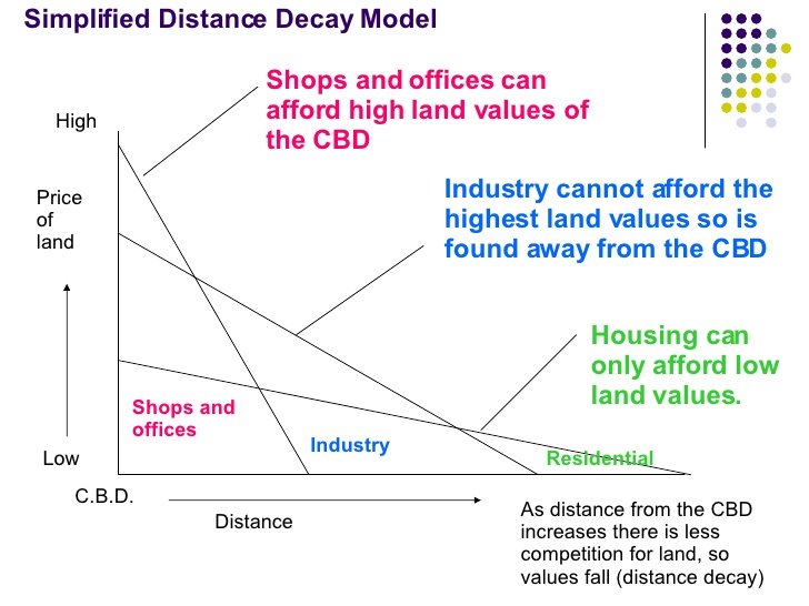
What is the Bid Rent Model? Describe general trends (3)
A model proposing urban spatial pattern is shaped by the changing land value, depending on its purpose & distance from the centre
Trends:
1) Land value gradient - Land value & rent decreases as distance from CBD increases
2) Economic competition - Different commercial land users compete for central locations