Geography paper 1 The Living World
1/68
There's no tags or description
Looks like no tags are added yet.
Name | Mastery | Learn | Test | Matching | Spaced | Call with Kai |
|---|
No analytics yet
Send a link to your students to track their progress
69 Terms
what is an ecosystem
a system in which organisms interact with each other and their environment
ecosystem components
abiotic- non living factors such as air, rocks, heat and water
biotic- factors that are living such as plants, animals and insects
flora- plant life occurring in a particular region or time
fauna- animal life of any particular region or time
food webs and chains, producers and consumers
food chains- a sequence of events in an ecosystem, where organisms eat each other. it starts with a producer (plant) then a primary consumer then secondary etc
food webs- a network of many food chains connected together
producer- plants that use photosynthesis and nutrients to create energy
consumers- animals that eat plants or other animals e.g. herbivores or carnivores
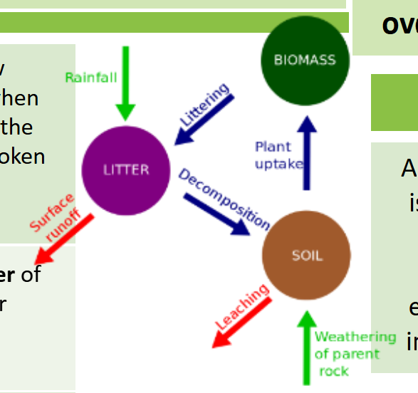
nutrient cycle
plants take in nutrients to build into new organic matter.
animals take in nutrients when they eat plants and the nutrients are retuned to the soil when the animal dies and the body is broken down by decomposers.
litter, biomass and soil
litter- the surface layer of vegetation which over time breaks down to become humus.
biomass- the total mass of living organisms per unit area
biomes
biome- large geographical area of distinctive plant and animal groups, which are adapted to that particular environment. the climate and geography of an area determines what biome can exist there
-more productive biomes= biomes that are the greatest in biomass= grow in climates that are hot and wet (humid)
tropical rainforest biome
location- along the equator
temperature- hot all year (25-50 degrees)
rainfall- very high (over 2000 a year)
flora- tall trees form a canopy
fauna- greatest range of animal species, most live in canopy layer
tropical grassland biome
location- between latitudes 5-30 north and south of the equator
temperature- warm all year (20-30)
rainfall- wet and dry season (500-1500mm)
flora- grasslands with widely spaced trees
fauna- large hooved herbivores and carnivores dominate
hot desert biome
location- found along the tropics
temperature- hot by day cold by night
rainfall- very low (below 300mm a year)
flora- lack of plant and few species adapted to drought
fauna- small nocturnal animals except the camel
temperate forest biome
location- between latitude 40-60 north of the equator
temperature- warm summers and mild winters
rainfall- variable rainfall
flora- deciduous trees and a variety of species
fauna- animals adapt to colder and warmer climates. some migrate
tundra biome
location- latitudes of 65 degrees north and south of the equator
temperature- cold winter and cool summers
rainfall- low (below 500mm)
flora- small plants grow close to the ground and only in summer
fauna- low number of species, most found at the coast
coral reef biome
location- found within 30 degrees north and south of equator in tropical waters
temperature- warm water all year round with temps of 18 degrees
rainfall- wet and dry seasons, rainfall varies greatly due to location
flora- small range of plant life including algae and sea grass
fauna- dominated by polyps and fish
tropical rainforest biome
covers 2% of the earths surface yet accounts for over 50% of the worlds plant and animals
interdependence in the rainforest
interdependence- where plants and animals depend on each other for survival.
if one component changes, there can be serious knock-up effects for the entire ecosystem. e.g. removal of the python can lead to more rodents which would eat more bird eggs.
rainforest nutrient cycle
-hot damp conditions on the forest floor lead to high levels of decomposition of dead plant material
-this leads to many nutrients being absorbed by plant roots
-however, as these nutrients are in high demand, they don’t remain in the soil for long and stay close to the surface
-this means soils are thin and poor as most nutrients are locked away in biomasses.
-leaching removes minerals but not iron= the soil is a red colour.
distribution of tropical rainforests
-centred along the equator
-found in south America, central Africa and south east Asia
-the amazon is the largest
layers of the rainforest
emergent- highest layer with trees reaching 50m. most light here
canopy- more life is found here as it receives 70% of the sunlight and 80% of life
under canopy- trees that reach 20m high
shrub layer- lowest layer with small trees that have adapted to being in the shade
climate of TRFs
clouds= temp doesn’t get higher than about 32 degrees= plants don’t scorch
heavy afternoon rainfall
the Hadley cell and convectional rainfall cause the climate
case study- Epping forest- small UK ecosystem- London/Essex
-English lowland deciduous woodland
-70% of the area is designated as a site of special scientific interest (SSI)
-60% is designated as a special area of conservation (SAC)
components and interdependence of Epping forest
spring- flowering plants (producers) such as bluebells store nutrients to be eaten by consumers later
summer- broad tree leaves to maximise photosynthesis
autumn- trees shed leaves to conserve energy due to sunlight hours decreasing
winter- bacteria decompose the leaf litter, releasing nutrients into the soil
ecosystem/ food web disturbance
-grey squirrels introduced= more disease and territorial= red squirrels die out
example of a food chain: shrubs, insects, mice, foxes
TRF Malaysia case study
Malaysia is made up of peninsular Malaysia and east Malaysia which is a part of the island Borneo.
67% of Malaysia is TRF
between 2000- 2013, the area of forest lost was larger than the area of Denmark
over 600 species and 25% of all plant species in Malaysia are found in the TRF
orangutans and tribes who practise slash and burn live in the TRF
issues related to biodiversity in Malaysia
high biodiversity rates due to:
humid climates= vegetation growth
rapid nutrient recycling rates
most of the TRF is untouched
value of rainforest in Malaysia to people and the environment
people- HEP crops, meat and fish, wafer, medicines and employment
environment- air purification, wildlife habitats, biodiversity and carbon sink
causes of deforestation in Malaysia
logging- largest exporter of tropical wood in the 1980
commercial and subsistence farming- largest exporter of palm oil. subsistence farmers such as tribes using slash and burn.
mineral extraction- mining for tin common in Peninsular Malaysia. oil and gas drilling has begun in Borneo
population growth- poor people encouraged by government to move from urban Malaysia to the countryside (transmigration) forest is then cleared for the settlers.
energy development- Bakun dam supplies energy for Peninsular Malaysia. 700km squared has been flooded.
road building- roads are needed to transport supplies and provide access to settlements and mining areas.
impacts of deforestation
economic development:
mining, farming and logging creates employment and tax income for the government
cattle ranching and soya bean production
loss of biodiversity reduces tourism.
soil erosion
once the land is exposed by deforestation, it is more vulnerable to rain
with no roots binding soil together, it can easily wash away
climate change
when rainforests are cut down, the climate becomes drier
trees are carbon sinks. loss of carbon sinks= less GHGs absorbed, so more greenhouse emissions in the atmosphere leads to global warming
trees are burnt, releasing carbon into the atmosphere and enhancing the greenhouse effect.
sustainability for the rainforest: ways to increase sustainability
uncontrolled exploitation= irreversible damage such as biodiversity loss, soil erosion and climate change. strategies include:
conservation- creating national parks/ areas of protected land
selective logging- trees are only felled when they reach a particular height, conserving other species
debt swap- when governments swap debt to conserve rainforests e.g. USA reducing debt for Brazilian rainforest
Hot desert: Thar desert India
found in the state of Rajasthan NW India and into Pakistan.
most densely populated desert in the world, slightly smaller than the whole of Uk
200,000km squared
characteristics of hot deserts
aridity- hot deserts are extremely dry with average rainfall below 250mm
heat- hot deserts get over 40 degrees
landscapes- some places have dunes, but most are rocky
distribution of the world’s hot deserts
found in the subtropics between 20 degrees and 30 degrees north and south of the equator.
usually run through the tropics.
climate of hot deserts
-less than 250mm rainfall per year
-only rains once every 2-3 years
-hot day temps (45) cold night temps (5) due to little clouds
-some winters may have frost or snow
interdependence in hot deserts
vegetation stops wind blowing sand and soil away, allowing plants to grow
cactus survival adaptations
widespread, shallow roots to absorb water soon after rainfall
needles instead of leaves to reduce surface area and so transpiration
thick waxy cuticle to reduce water loss through evaporation
camel adaptations
hum stores fat which can be metabolised for energy
large, flat feet to spread on the sand for balance and to prevent sinking
tough tongue to eat cacti
thick eyelashes to keep sand out eyes
large surface area to volume ratio to increase heat loss
opportunities of hot deserts
-valuable minerals for extraction= job opportunities
-rich in energy. oil found in Barmer district could be transformative. Jaisalmer wind farm is India’s largest wind farm. solar energy ideal due to the sun.
-tourism: many visit from Pakistan. safaris are popular
-farming: grazing in grassy areas cultivating for fruit and veg. commercial farming of wheat and cotton= job opportunities
challenges in hot deserts
-heat= difficult to work outside for too long
-water shortages are common= people need to adapt to low water
-aquifers are salty and poor quality
-accessibility is poor due to rough roads and tarmac melting. buses are overloaded.
causes and definition of desertification
desertification- the turning of semi-arid areas (drylands) into deserts
population growth- high fertility rates= growth. poverty= economic migration so higher water demands
fuel wood (pop growth)- people rely on wood for fuel. deforestation= soil exposure which dries up.
over cultivating/ over grazing (pop growth)- if crops are grown in the same areas too often, nutrients are used up causing soil erosion. too many cattle= overgrazing= soil erosion
strategies to reduce desertification
water management- growing crops that don’t need much water. collecting water on roofs.
tree planting- trees protect the soil from wind and soil erosion e.g. Africa’s great green wall.
soil management- leaving areas of land to rest and recover lost nutrients. building low walls to stop soil erosion.
natural hazard definition
a natural process which could cause death, disruption or injury to humans, properties and possessions.
types of natural hazard
tectonic- caused by land and tectonic processes (earthquakes, volcanos)
geomorphic- events that happened on earths surface (flooding, landslides)
atmospheric- caused by weather and climate
biological- hazards involving living things (forest fires)
factors affecting the risk of hazards
location- plate margins, volcanos, equator
poverty- LICs, island nations
population density- rural/urban
GACM rules
hot rising air= low pressure, stormy wet cloudy weather at equator= rainforests
cold sinking air= high pressure, dry clear weather, at tropics= deserts
wind is the movement of air. surface winds always moves from areas of high to low pressure.
Coriolis effect- the earth’s rotation deflects the winds as they blow from areas of high to low pressure and earth rotates from west to east
tropical storm conditions
low pressure systems
between 5-20 degrees N
sea must be above 26 degrees for several days (usually during autumn)
trade winds
sea needs to be 70m deep
250-300 mm rainfall
formation of tropical storms
-in summer and autumn, sun heats ocean causing warm moist, air to rise
-once 27 degrees, rising warm air causes low pressure which turns into a thunderstorm.
-this causes air to be sucked in from trade winds.
-the thunderstorm spins due to Coriolis effect.
when storm spins faster than 74mps, a tropical storm forms.
-cool air sinks in the centre of the storm, creating the eye.
-when it hits land, the storm loses energy and dies.
effect of climate change on tropical storms
increased climate change= increased tropical storms as oceans reach 26+ degrees more often
warmer atmosphere holds more moisture holds more moisture= heavier rainfall.
primary effects of tropical storms
-death, destruction of buildings, communities and communication
-shortage of clean water and sanitation
-winds cause high waves= storm surges which account for 90% of deaths
secondary effects of tropical storms
-disease
-homelessness= poverty, distress, illness due to lack of shelter
-damaged businesses= unemployment
-damaged crops= food shortage
short term responses to tropical storms
rescue, search, helping the injures
long term responses to tropical storms
rebuilding schools building homes, kickstarting the local economy
Nepal earthquake 2015 LIC
7.8 magnitude
primary effects- 8600 dies, 21,000 injured, 3.5 million made homeless, Dharahara tower destroyed (popular tourist spot)
secondary effects- 10,000 landslides, one destroyed the village of Langtang, human trafficking levels raised, area received 10x the usual amount of landslides
short term responses- simple tools used by locals to recover people, 4.3 million given food rations for months, countries sent rescue teams
long term responses- government sent $3000 to affected families to rebuild their homes (some didn’t spend the money accordingly) cash for work scheme meant locals were paid to rebuild parts of the city, Oxfam provided sustainable living spaces, food, sanitation and jobs. UK provided waterproof shelters.
Chile earthquake 2010- HIC
8.8 magnitude Earthquake 500x more powerful than Nepal earthquake
primary effects- 500 died, 12000 injured, buildings destroyed and communications cut
secondary effects- tsunamis in coastal areas, 70k left the city, cost $30 bn to repair schools + hospitals
short term responses- emergency services supplied, field hospitals, communications restored, temporary repairs to infrastructure, power and water restored to 90% of homes within the first ten days
long term responses- national appeal raised $60bn, 300 shelters built, strong economy meant little international aid was required.
Prediction, protection, planning
prediction- constant monitoring gives advanced warning of tropical storms (seismometers)
protection- building construction projects to reduce the risk of buildings collapsing
planning- involves getting people and services ready to deal with impacts. emergency storm shelters can be built and drills take place in public buildings.
UK Heatwave, July 2022
UKs hottest ever temp of 40.3 C
34 locations exceeded the previous hottest temp of 38.7 in 2019
5 died due to drowning
London fire brigade declared a major incident after several fires broke out in the capital = busiest day since ww2
250+ firefighters tackled 3 fires in london
operating theatres were too hot so surgeries cancelled.
Natural causes of climate change
Sun spots (solar outputs) small dark patches of suns surface. more sun spots= more solar output= solar flares. less sun spots= less solar output
the structure of the Earth
the crust- varies in thickness (5-10km) made up of several large plates. oceanic crust is denser but thinner. continental is thicker but less dense
the mantle- widest layer (2900km) the heat and pressure means the rock is in a state of convection
the inner and outer core- hottest section (5k degrees) mostly made of iron and nickel and is 4x denser than the crust. inner section is solid, outer section is liquid
convection currents
the crust is divided into tectonic plates which move sue to convection currents in the mantle
-radioactive decay of some of the elements of the mantle and core generate lots of heat
-as molten magma towards the bottom of the mantle heat up, they become less dense and begin to rise
-as they rise to the top, they begin to cool down, become denser and so sink
-this circular movement is convection current
-the convection currents create drag on the bottom of the tectonic plates, causing them to move
why continue to live in tectonic areas?
confidence in technology
benefits- water and fertility
family ties
poverty
destructive plate margins
denser oceanic plate subducts under the less dense continental plate, resulting in the release of pressure due to friction. this friction causes the oceanic plate to melt and become molten magma. this forces it’s way up the continental plate and forms a volcano.
the release of energy also causes earthquakes
how are ocean trenches formed
they are formed in a destructive plate margin, where the two plates meet and the continental plate crumples into fold mountains
constructive plate margin
two plates moving apart causing new magma to reach the surface through the gap
volcanoes formed across this crack cause a submarine mountain range
conservative plate margin
where two plate margins slide past each other in opposite directions or in the same direction at different speeds. this causes earthquakes.
causes of earthquakes
caused when two plates become locked, causing friction to build up. from this stress, the pressure will eventually be released triggering the plates to move into position, this movement causes energy in the form of seismic waves to travel from the focus to the epicentre. as a result, the crust vibrates triggering an earthquake
epicentre, seismic waves, focus
epicentre- the point directly above the focus, where the seismic waves reach first
seismic waves- energy waves that travel out from the focus
focus- the point where pressure is released
atmospheric circulation
the large scale movement of air by which heat is distributed on the surface of Earth
global pattern of air circulation
Hadley cell- largest cell which extends from the equator between 30 to 40 degrees north and south
Ferrel cell- middle cell where air flows poleward between 60 and 70 degrees
Polar cell- smallest and weakest cell that occurs from the poles to the Ferrel cell
management and monitoring storms
protection- construction projects that improve protection
development- the scale of the development depends on whether the country has the resources to cope with the storm. LICS tend to struggle with technology
prediction- constant monitoring and installing warning systems gives advanced warning for storms
aid- involves assisting after the storm, usually in LICs
planning- emergency storm shelters can be built and communicated to vulnerable populations
education- reduces panic
Typhoon Haiyan 2013 causes
started as a tropical depression on 2nd November 2013 and gained strength. became a category 5 super typhoon and made landfall on the Pacific islands of the Philippines. 5 storm surges hit the coastline. 341mph winds
typhoon Haiyan primary and secondary effects
6,500 deaths
130,000 homes destroyed
emotional grief
water and sewage destroyed= disease
30k boats destroyed
water shortages
typhoon Haiyan short and long term effects
the UN raised £190 million in aid
UK and USA sent carrier ships
education on typhoon preparedness
cash for work programme
Oxfam assisted new fishing boats
1,200 evacuation centres set up