Estuaries - Exam 3
1/55
There's no tags or description
Looks like no tags are added yet.
Name | Mastery | Learn | Test | Matching | Spaced | Call with Kai |
|---|
No analytics yet
Send a link to your students to track their progress
56 Terms
Estuary
A partially enclosed body of water where freshwater and saltwater mix; where rivers meet the ocean. Classified based on their geology and hydrology.
Classification of estuaries based on geology
-Drowned-river valley or coastal estuary
-Bar-built estuary
-Delta estuary
-Tectonic estuary
-Fjords
Drowned River Valley Estuaries
Form when sea levels rise, and seawater invades low-lying lands and river mouths. Formed ~15,000-18,000 years ago during the Pleistocene when sea levels rose.
~Ex: Chesapeake Bay
Bar-built estuaries
Form from an accumulation of sediment along the coast, separating a section of the coast where freshwater enters
-Ex: Laguna Madre (TX) and Pamlico Sound (NC)
Delta estuaries
Form at the mouths of large rivers from sediment and silt deposition; when river flow is restricted by a delta, an estuary may form.
-Ex: Mississippi River Delta Estuary
Tectonic estuaries
Form when land subsides (sinks) in the Earth, often caused by tectonic activity such as earthquakes. Common along fault lines.
-Ex: San Francisco Bay
Fjords
Formed when glaciers cut out long, narrow valleys with steep sides that were inundated when sea levels rose.
Classification of estuaries based on hydrology
-Salt wedge
-Partially mixed
-Well-mixed
-Reverse
Salt wedge estuaries
Occur when a large, powerful river flows into the ocean and tidal mixing is small; the river flow is so strong it pushes back the seawater, creating a strong, wedge-shaped halocline.
-Ex: Mississippi River Delta Estuary
Partially mixed estuaries
Have a tidal flow that eliminates a salt wedge; mixing of the waters, although there is a tendency for a stagnant layer of saltwater to form on the bottom.
-Ex: San Francisco Bay
Well-mixed estuaries
Have low river flow and strong tidal action, mixing the saltwater throughout a shallow estuary.
-Ex: Delaware Bay
Reverse estuaries
Form in dry areas with low precipitation, high evaporation, and little to no river input. Tidal action reverses the flow and produces a salinity gradient of increasing salinity from the ocean to the estuary.
-Ex: Laguna Madre
Tectonic estuaries form when
a.) Sand bars form along the coast
b.) Seawater invades lowlands and river mouths
c.) Retreating glaciers cut a valley along the coast
d.) Sea levels fall during glaciation
e.) Land subsides along the coast
e.) Land subsides along the coast
The most common type of estuary is a:
a.) Drowned river valley estuary
b.) Fjord estuary
c.) Delta estuary
d.) Bar-built estuary
e.) Tectonic estuary
a.) Drowned river valley estuary
The Mississippi River Delta Estuary is an example of a
a.) Partially mixed estuary
b.) Reverse estuary
c.) Salt-wedge estuary
d.) Well mixed estuary
c.) Salt-wedge estuary
This type of estuary lacks a halocline:
a.) Salt wedge estuary
b.) Well mixed estuary
c.) Partially mixed estuary
d.) All of the above have a halocline
b.) Well mixed estuary
Physical characteristics of estuaries
-Salinity
-Substrate
-Temperature
-Turbidity
-Oxygen
Salinity can be variable and depends on
freshwater input, precipitation, evaporation, and tides.
Freshwater inflow is dependent on [blank] of the [blank] and [blank].
Topography; watershed and size of river
What decreases salinity?
Heavy rain and storms can decrease salinity
How does evaporation impact salinity?
High rate of evaporation in the summer increases it.
How does salinity vary depending on the tidal action and pattern (diurnal, semi-diurnal)?
Peaks at high tide due to influx of ocean water, drops at low tide as freshwater flows out.
In estuaries, the internal (blank) of organisms tend to be (blank) than the surrounding environment.
salt concentration; higher
Osmoconformers
Allows their body fluids to change with the salinity of the water, ex: mussels, polychaetes.
Osmoregulators
Keep the salt concentration of their body fluids more or less constant regardless of the salinity of the environment, ex: fish, crabs.
Substrate of estuaries
typically soft sand or mud
Sediment size depends on the what of the current?
Strength; course materials settle in the upper reaches of estuaries. Fine particles are carried downwards.
Estuary organisms burrow or anchor to substrate?
Burrow. There’s no hard substrate to anchor to.
Dissolved Oxygen (DO) levels in the water get high when?
There is mixing. It decreases as the temperature and salinity increases though. So, it’s lowest in late summer.
How can sediments and bottom waters tend to be anoxic?
-Water can become stratified due to density differences, with more saline and oxygen-poor waters at the bottom.
-Decomposition of organic material on the bottom by decay bacteria depletes oxygen in bottom waters.
Adaptations in estuaries when there’s low oxygen
-Mobile organisms can leave the area when DO levels become too low
-Some organisms pump water into burrows or have specialized hemoglobin that can hold and carry oxygen in low oxygen conditions.
-Some organisms have the ability to survive long periods of time without oxygen.
Turbidity in estuaries are what level? High or low?
High due to the high sediment load carried in by freshwater inflows. Decreases light penetration, which reduces primary production.
Euryhaline species…
Can tolerate changes in salinity
Blood rich in hemoglobin is an adaptation to…?
Low oxygen
Estuaries are low in biodiversity, but are what due to….?
But are biologically rich and very productive ecosystems, due to nutrients carried in from rivers and tides which are used by plants, algae, and bacteria, forming basis of the food web.
Some species complete their entire life in the estuary, but many have a…? Why?
Two-phase system in estuaries and continental shelves. Differences in habitats drive this.
~Ex: Blue crabs use estuaries as adults for feeding and spawning; while larvae are planktonic over continental shelf habitats.
~Another ex: Gulf menhaden use estuaries as larvae and juveniles, then use continental shelf habitats as adults to feed and spawn.
~Another another example: Striped bass use estuaries during their larvae and early juvenile stages, use continental shelf habitats to feed as adult, and then return to estuaries to spawn.
~LAST EXAMPLE: some cartilaginous fishes use estuaries as nursey grounds and continental shelves/open ocean waters as adults.
Estuarine Communities
-Mudflats
-Salt marsh
-Mangroves > covered in Marine plants
-Oyster Reefs
-Seagrass beds > covered in continental shelf habitats
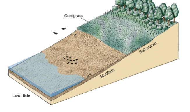
Mudflats
covered in soft bottom intertidal habitat
Salt marsh communities
-Border estuaries in the mid to high latitudes
-Source of nutrients to estuaries via detritus
-Protect the shore against erosion by buffering wave energy and trapping sediment
Ecological significance of estuaries
-Among the most productive marine ecosystems
-Important habitat for critical life stages of many marine species.
-Birds, fish, amphibians, insects, and other wildlife depend on estuaries.
Economic significance of estuaries
-Important habitat for commercially and recreationally important species
-Important recreational areas
-Important centers of transportation and commerce.
Summary of what happened to the salt marsh community in NOLA.
-Land has been disappearing in Louisiana at a rate of ~17 mi2 of land; majority is salt marsh/wetlands.
-Dredging of canals is a major factor in the decline of salt marsh habitats surrounding New Orleans
-Mississippi River has been heavily modified, including the construction of the Mississippi River-Gulf Outlet (MRGO) by the U.S. Army Corps of Engineers in 1968.
-As predicted, the MRGO caused extensive erosion, turbidity, altered the salinity regime of marsh, with an estimated habitat loss of ~0.3 mi2/year
-Lead to flooding in NOLA from Hurricane Katrina
What puts estuaries at risk?
-Oil and gas pollution
-Heavy metal and chemical pollution
-Marine debris
-Fisheries, including aquaculture
-Climate change
-Shipping
-Dredging, construction
-Noise
-Tourism and boat traffic
-Adverse weather
-Habitat loss
-Freshwater inflow
-Eutrophication
-Hypoxia
The issue with freshwater inflow with the Mississippi River summary
-Human-natural hybrid river, extensively engineered for almost 100 years
-Levees prevented sediment in floodwaters from naturally building the delta.
-In the mid-1900’s, the Mississippi River started to divert to the Atchafalaya River, but it was manually directed to flow where the river is today.
-Sediment was/is dumped into deeper gulf waters instead of naturally building the delta
-Flooding continued despite levees, these levees reduced the flow of freshwater into estuaries and wetlands
-Led to a substantial increase in salinities and a decrease in sedimentation
-In 1991, the Caernarvon Diversion was built downriver from New Orleans to purposely push freshwater into Breton Sound to lower salinities, promoting oyster growth.
-Added bonus of preventing further destruction of marsh habitat.
-Consensus in 2001 on diversions and flow regime was that a pulsed flow of freshwater most closely mimics natural flow.
-As of 2012, there were 16 diversions in the lower Mississippi River Delta with up to 12 more proposed.
-Not clear whether these diversions are sufficient to prevent habitat loss.
Oyster Reefs
-Forms expansive beds on muddy bottoms of estuaries in temperate areas of North America, Australia, and Europe.
-Provide complex structure for other organisms to settle on.
-Promote clear water via filtering the water
-Protect shore from erosion by waves
-Commercial fisheries
Oysters tolerate what range of salinity?
A wide range; 5-40. Duration of low salinity appears to be important.
-Salinity of <5 for a long period of time negatively impacts recruitment, survival and growth.
Oyster Reefs in Breton Sound
-Supports important oyster reefs, but oysters are threatened by changing hydrology.
-In 2010, oyster recruitment, growth, and survival was negatively impacted by low salinities (<5) for an extended period of time through hot summer months.
-In 2011, low salinities (<5) occurred for a shorter period and did not extend throughout summer and oysters were minimally impacted.
-Survival dependent on oysters’ ability to osmoconform and duration of ‘closing up’.
Oyster Reefs in MS Sound
Estimated that Mississippi Sound has lost 90% of its oyster reefs.
-Restoration initiatives included re-establishing reefs with shells/hard substrate for larvae to settle. Monitor water quality, salinity. Manage fishery to prevent overharvest.
Describe how estuaries are classified based on geology and hydrology
-Geology = formation (drowned river valleys, fjords, bar-built, tectonic)
-Hydrology = water circulation and salinity mixing (salt wedge, partially mixed, well-mixed)
Geological:
-Drowned River Valleys: formed at the end of the last ice age as rising sea levels filled existing river valleys. Ex: Chesapeake Bay
-Fjords: V-shaped valleys carved by glaciers and flooded by rising sea levels. Often has a shallow sill at the mouth that restricts water exchange.
-Bar-built estuaries: formed when barrier islands or sandbars are built up by ocean waves and currents along the coast, separating a shallow lagoon from the ocean.
-Tectonic estuaries: Geological faults cause the Earth’s crust to sink, allowing the sea to flood the area. Ex: San Francisco Bay
-Delta System: Formed when rivers flow into the ocean and deposit large amounts of sediment, creating tidal freshwater areas. The river flow is so high it restricts the ocean’s influence.
Hydrological:
-Salt wedge (highly stratified): fast-flowing, large river empties into a low-tidal basin. The lighter, fresh water flows over the denser, saltier ocean water, forming a distinct wedge-shaped layer on the bottom.
-Partially mixed estuary: Tidal flow creates turbulence, mixing the seawater and freshwater together, more saline on bottom , fresher on top.
-Well-mixed (vertically homogeneous): Strong tidal mixing; water is thoroughly mixed from top to bottom, resulting in similar salinity throughout the water column.
Describe the physical characteristics of estuaries and how estuarine organisms adapt to their environment.
-Physical characteristics of estuaries: freshwater meets the ocean, creating nutrient-rich, brackish water with fluctuating salinity, tidal levels, and oxygen concentrations. Is protected from the sea by barrier islands, peninsulas, etc… the mixing of water bodies and decaying organic matter creates nutrient-rich soil too.
-Organisms adapt through specialized mechanisms like behavioral, physiological, and morphological changes such as closing shells, burrowing, or excreting excess salt. Some organisms can switch from aerobic to anaerobic respiration when oxygen levels decrease.
Describe the different ways marine organisms utilize estuaries.
-Nurseries for juvenile species, rich feeding grounds, protected shelters for breeding, and essential transition zones for migratory fish adapting to changing salinity levels.
Explain why salt marsh habitat is important and how the loss of salt marsh habitat has impacted the Mississippi River Delta region
Saltmarshes protect coastal communities from storm surges, filter pollutants, and act as nurseries for fish.
Their loss is driven by sea-level rise, infrastructure, and oil spills. Plus, economic factors like overfishing. As the protective “buffer” of marshland disappears, coastal communities are becoming more vulnerable to damage from storms.
Describe the ecological and economic importance of estuaries
-Ecological: productive marine ecosystem (spawning, breeding, feeding)… important habitat for critical life stages of many marine species. Birds, fish, amphibians, insects, and other wildlife depend on estuaries. Natural filters, so they trap pollutants, sediments, and excess nutrients from river runoff, improving water quality before it enters the ocean. Protect shorelines by acting as buffers against storm surges, floods, and sea-level rise.
-Economic: Commerical fishing (important habitat for commerically and recreationally important species), ports are located in estuaries due to their calm, sheltered waters. Important recreational areas (kayaking, snorkeling, etc.).
Describe how freshwater inflows impact estuaries, using the Mississippi River and the Mississippi River Delta as examples.
-Freshwater inflows: provides nutrients. Keeps salinity low enough for aquatic life. Supports habitats such as saltmarshes, as without it, it accelerates erosion and killing vegetation. Provides necessary sediment to replenish wetlands. The nutrients in the freshwater fuel the growth of marsh grasses, strengthening the coastline. The nutrients and phytoplankton transported by the MS River nourish entire food web, which supports vital commerical and recreational fisheries.
-MS River Delta: Due to dams and levees, MS delta has lost tons of land as the levees restrict the natural flow, preventing sediment from reaching the marsh, which leads to saltwater intrusion and erosion.
-MS River: The Atchafalaya River, apart of the MS River, shows the power of freshwater inflow, as sediment continues to build new delta land, contrary to the overall decline.
-Consequences of Reduced Freshwater Flow: Saltwater intrusion (sea level rise, plus increased salt concentration which kills plants), loss of nutrient input, and reduced sedimentation (lack of land building)
Explain the importance of oyster reefs and the role of salinity regimes in the health of oyster reefs, citing examples in Breton and Mississippi sounds.
-Importance of Oyster Reefs: water quality enhancement (oysters are natural filter feeders, reducing excess nutrients and sediment), habitat provision, and coastal protection.
-Role of salinity: Has to have optimal conditions for reefs (MS sound needs 10.0-16.0 ppt), low salinity from excessive runoff or flood causes massive mortalities, and high salinity increases disease and predators.
-Examples: in the MS sound, multiple openings of the Bonnet Carre spillway and heavy rainfall has led to low salinity, causing massive die-offs
With the Breton AND MS sound, there’s been restoration efforts like oyster nurseries and selecting sites with ideal salinity to ensure long-term survivability.