Unit 9: Navigation | Charts and Publications
1/31
There's no tags or description
Looks like no tags are added yet.
Name | Mastery | Learn | Test | Matching | Spaced | Call with Kai |
|---|
No analytics yet
Send a link to your students to track their progress
32 Terms
Class A Airspace
18000 ft MSL > 60000 ft MSL | Not depicted on sectional charts
Class B Airspace
SFC > 10000 ft MSL although outer parts of circle can be from higher altitudes up to 10000. | Depicted by Heavy blue lines | ATC clearance required for all aircraft | TAC shows which facility to contact and proper frequency | Visibility: 3 SM & Clear of Clouds
Mode C Veil (FAR 91.215)
30 nm veil | ADSB-out and Mode C transponder are required for all aircraft regardless of altitude | Depicted by Thin magenta circle
Class C Airspace
SFC > 4000 ft MSL, shelf area usually from 1200 ft MSL > 4000 ft MSL | Depicted by solid magenta lines | Visibility: 3 SM & Cloud Clearance: 1000ft above, 500 ft below, 2000 ft horizontal
Class D Airspace
Usually SFC > 2500 ft MSL, minus sign in front indicates from surface to but not including stated MSL altitude | Depicted by dashed blue lines | Visibility: 3 SM & Cloud Clearance: 1000ft above, 500 ft below, 2000 ft horizontal
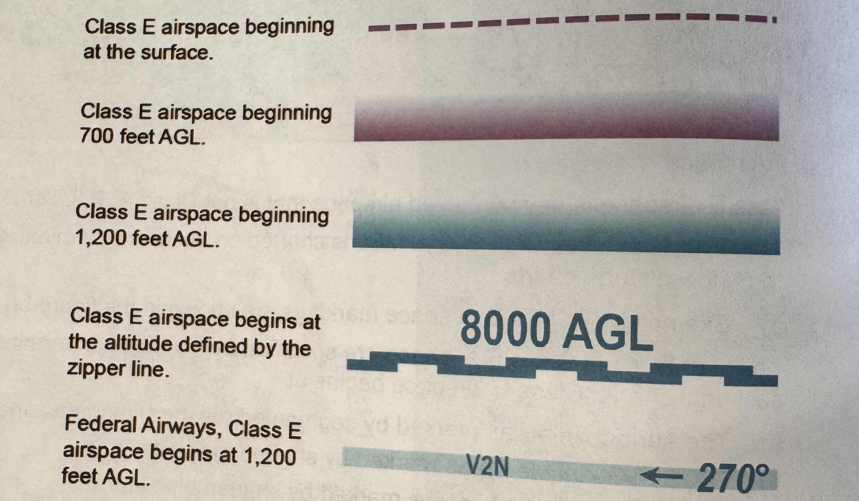
Class E Airspace
Any controlled airspace that is not Class A, B, C, D, if it is below 14500 ft MSL it is charted on sectional/terminal/IFR | Begins at SFC in areas marked by dashed magenta lines, 700 ft AGL in areas marked by shaded magenta lines, 1200 ft AGL outside areas marked by shaded blue lines or if not present then begins at 1200 ft AGL unless otherwise designated. Extends up to but does not include 18000 ft MSL. All airspace above 60000 ft MSL is Class E. | Inside an area marked by shaded blue lines, floor is either 14500 ft MSL or 1200 ft AGL, whichever is higher | Blue zipper marks depict specific altitudes | 1200 ft AGL in Federal Airways (VG-120) |
Class G Airspace
Uncontrolled airspace and not depicted on sectional charts, implied that it exists everywhere controlled airspace does not exist | Extends upward from SFC to floor of overlying controlled airspace. Class G Airport is any airport where Class B,C,D,E airspace does not extend to the surface
Prohibited Areas
Flight of aircraft is completely prohibited, depicted by blue hashed lines and labeled with a P following a number (P-40)
Restricted Areas
Unusual and often invisible hazards exist to aircraft. Not entirely prohibited, but subject to restrictions. Labeled with an R following a number (R-4401 A & B). Must obtain permission from controlling agency to fly through even though might not always be in use.
Warning Areas
Contain activity that may be hazardous to nonparticipating aircraft (aerial gunnery, guided missiles). Depicted by blue hash lines and labeled with a W following a number (W-237B). Extend from 3NM outward from the US coast can be located over domestic and/or international waters | No entry requirement, be alert over water
Military Operation Areas (MOA)
Separate certain military training areas from IFR traffic, depicted by magenta hashed lines and are not numbered (EG: Camden Ridge MOA). Pilots should contact any Flight Service Station within 100 mi. of the area to obtain accurate information regarding the MOA hours of operation. Prior to entering, contact controlling agency for traffic advisories, back of sectional chart has times of operation, altitudes affected, and controlling agency.
Alert Area
Airspace where there is a high volume of pilot training or an unusual type of aerial activity, depicted by magenta hashed lines and labeled with an A (A-211)
National Security Area
Consists of airspace of defined vertical and lateral dimensions established at locations where there is a requirement for increased security and safety of ground facilities.
Special Flight Rules Area (SFRA)
Special rules in effect, must have taken a special class through FAA to have permission.
Controlled Firing Areas (CFA)
Contain activities that, if not conducted in a controlled environment, could be hazardous to nonparticipating aircraft. Not depicted on sectional charts. Military is responsible for avoiding you, no restrictions but still be cautious.
IR, VR,Military Training Routes (MTR)
IR means that routes are made in accordance to instrument flight rules.
VR means the routes are made in accordance with visual flight rules
MTR: Established below 10000 ft MSL for operations at speeds in excess of 250 kt and depicted on sectional charts by a thin gray line. MTR 4 digit number: no segment above 1500 ft AGL., 3 digit number: One or more segments above 1500 ft AGL.
Terminal Radar Services Areas (TRSA)
Provide separation between all IFR and participating VFR aircraft. Primary airports within TRSA become Class D. Depicted by solid/grey line.
VFR Transition Routes
Used by VFR traffic to transit around complex airspace. They may be referred to as a VFR flyaway, VFR corridor, Class B Airspace VFR transition route, terminal area VFR code.
Temporary Flight Restrictions on Chart?
No, because of their temp nature.
Special Conservation Areas/Marine Sanctuary Designated Areas
Special Conservation: Pilots are requested to operate above 2000 ft AGL
NOAA Marine Areas: Pilots are required to operate above 2000 ft AGL

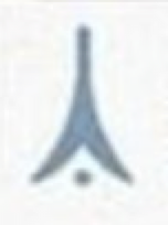
What obstruction is this symbol?
Obstructions of a height less than 1000 ft AGL

What obstruction is this symbol?
Group of obstructions less than 1000 ft AGL
What obstruction is this symbol?
Obstructions of height of 1000 ft AGL or more

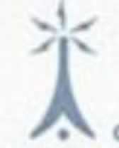
What obstruction is this symbol?
Group of obstructions more than 1000 ft AGL

What obstruction is this symbol?
High-Intensity Obstruction light below 1000 ft AGL
What obstruction is this symbol?
High-Intensity Obstruction light at 1000 ft AGL and higher

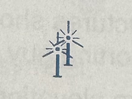
What obstruction is this symbol?
Wind Turbine
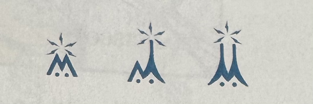
What obstruction is this symbol?
Group obstruction of wind turbines.
What obstruction is this symbol?
High intensity lights may operate part time or by proximity activation
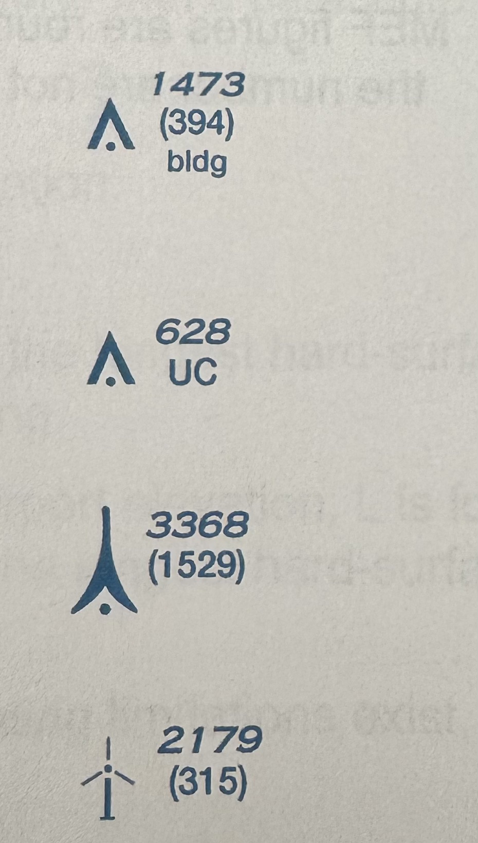
What are the heights of the following?
Bold number: Top of obstruction in feet above MSL
(Light number): Height of obstruction in AGL
The MSL elevation at base of the obstruction is the bold number minus light number, us this to compute terrain elevation
You must maintain at least 1000 ft above obstructions in congested areas and 500 above obstructions in other areas, and 2000 ft horizontally.
Maximum Elevation Figure (MEF)
Highest elevation within a quadrant, including terrain and other vertical obstacles (towers, trees, etc.)